Houston so far today has missed out on heavy rain as the showers have developed mostly to our west and north. Here’s a look at rainfall totals, through 11 a.m. CT, for the last 24 hours.
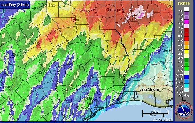
Note that whopping foot-plus of rain just to the east of Shreveport.
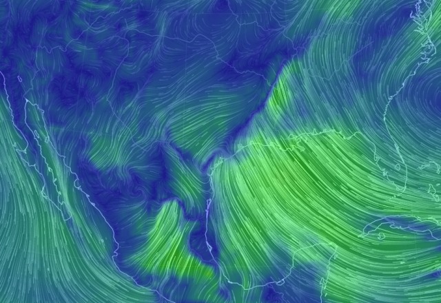
Despite the paucity of rain so far I still think there’s a reasonable possibility that we’ll see some additional thunderstorm development later today. The principal reason that a nearby front is lining up close to the metro area, and this could serve as a source of lift for all of this atmospheric moisture.
The front can be seen in this map of surface winds:
As this front pulls back north tonight I think we can expect to see a gradual end to the threat of very heavy rain. However with all of this atmospheric moisture I think we’ll continue to see intermittent rain and thunderstorms through Saturday morning.
Posted at 12:10 pm CT on Wednesday
From various radar loops, it appears that there is a lot of moisture coming off the Gulf but as soon as it hits the coast it is not getting the lift into the upper atmosphere. After it passes over the coastal counties the mositure is getting that lift and there is a lot more rain north, west and northeast of Houston than what we are seeing in Houston.
Kind of looks like a Monet painting