In brief: Tropical Storm Bertha is expected to fall apart before reaching the Texas coast. While there is a slight chance of showers by Friday in Houston, it’s more likely that this week is just hot, with 100s likely tomorrow and possible today and Thursday. More hot weather continues into next week.
Tropical Storm Bertha
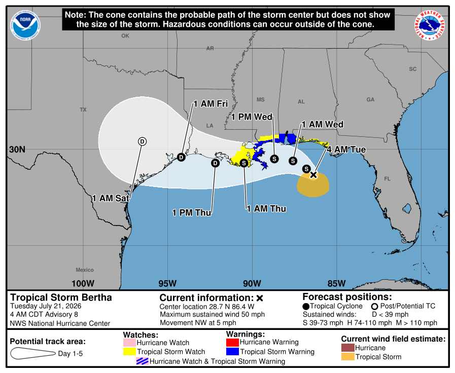
If you looked at satellite imagery this morning, you might ask yourself, “Really? Tropical Storm Bertha?” And without getting too into the weeds, all I will say is, “Yes. It is by definition technically a tropical storm. Just go with this.”
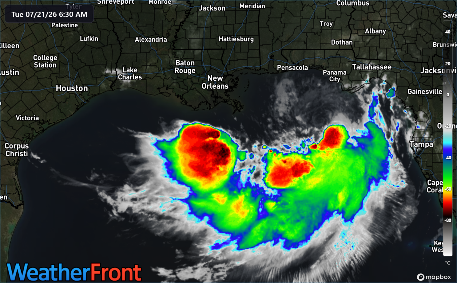
The aesthetics are off here, but that’s how these things work sometimes. Anyway, the actual surface center of 50 mph Bertha is located north of the thunderstorm activity, just south of Panama City, an indication that we’re dealing with a rather unhealthy tropical storm. Over the next 24 to 48 hours, Bertha is going to get blasted by wind shear, resulting in a gradual, perhaps quick weakening. So the storm may reach its peak today.
Bertha will continue westward, and the NHC track shows it reaching the Upper Texas Coast as a depression on Thursday night. The thought is that shower and thunderstorm chances would increase as a result on Friday, but even that may be a stretch. Realistic impacts would be slightly elevated tides and perhaps some breezy northeast winds (20-30 mph) in Galveston Thursday or Friday. Beyond that? It seems unlikely at this point that we’ll see anything more. And it may be generous to assume Bertha even survives the trip.
There is a little heartburn about, “Well, what if Bertha tracks farther south than expected?” We’re watching that, but even in that case, there’s a lot of dry air surrounding Bertha and the type of shear Bertha is set to experience usually decimates weak systems like this. We’ll obviously keep watching, but we really don’t believe this will impact Texas in a meaningful way. And there’s a decent, if not good chance we don’t notice any real impacts at all.
Heat wave
For those of you wondering if we’d ever see real heat this summer in Houston, you’ll get your answer over the next 3 to 4 days. That northeast wind shear that pummels Bertha is actually going to help deliver slightly drier air to Houston. Yes, humidity levels will be somewhat lower, but that will serve to crank up temperatures (drier air heats up more efficiently than more humid air). Not so much a “dry heat” as a very hot and somewhat humid setup.
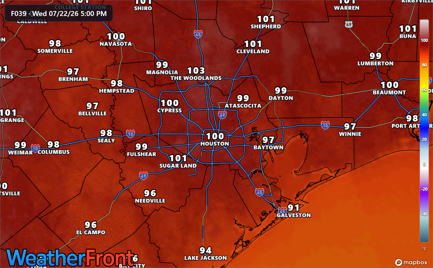
We should see highs into the upper-90s, if not near 100 degrees today. Tomorrow is Houston’s best chance to exceed 100 degrees and feels like one of those days that could be the hottest of summer. Obviously, we won’t say that it will be with all of August still in front of us. But you get the idea. It’s going to be hot. Exercise maximum heat precautions tomorrow. Heat risk will be in the “extreme” category, the type of elite we get usually a few days each summer. Heat advisories are posted today, and we’ll see if those get upgraded to “extreme heat warnings” tomorrow.
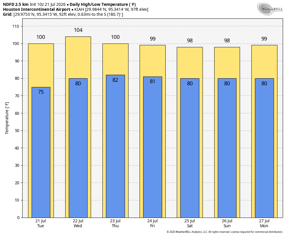
It stays quite hot into early next week, although we lose that crème de la crème type heat. Unfortunately, our nighttime lows look to crank up as well, with more lows near 80 degrees with a return to more typical humidity levels for the end of July. If Bertha’s remnants can bring us some showers Friday, we may be a little cooler both Friday and Saturday. But not by a lot.
When does it end? The humorous answer would “after August.” The more realistic answer is that temperatures may slowly adjust down some with gradually increasing rain chances later next week. We shall see. In the meantime, buckle up if you’ve been waiting for this sort of weather, or become a recluse if you’ve been dreading this sort of weather. It’s going to be a little bit.
