Good morning, and happy Friday. Unfortunately, if you came to the blog seeking good news about sunshine and beautiful late winter weather this weekend, we are going to have to direct you elsewhere. It appears that Southeast Texas is going to be under the influence of an unsettled, somewhat dreary weather pattern for several days. But, if you needed a break from the colder weather, you will get that over the next few days as well.
Today
We’ve got a few showers in the Houston area this morning. An occasional, brief heavy downpour is possible.
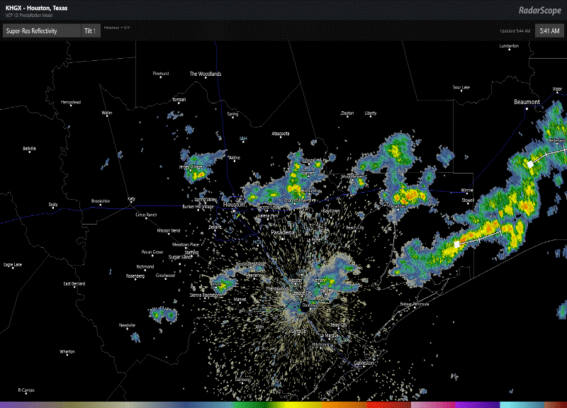
Be on the lookout for some patchy areas of fog this morning as well. Otherwise, cloud cover should dominate the picture today. We may see a few breaks of sunshine, but I would not be too optimistic at this point. Shower chances may be mostly over after this morning, but we wouldn’t rule out a few showers later this afternoon, mainly west of the Houston area or along the immediate coast.
It will be milder again today, with high temperatures peaking in the mid-60s in most places, though some spots are likely to hit the upper-60s.
Tonight & Saturday
The weather pattern over the next several days will feature quick moving disturbances, none of which look particularly strong. Because of that, trying to time the best rain chances will be a little challenging. Tonight looks mostly dry, but a disturbance passing through on Saturday could set off a few showers or even a thunderstorm. Not everyone will see rain, but some of us could see briefly heavier downpours.
Temperatures will top off around 70 degrees on Saturday afternoon, after beginning the day in the mid- to upper-50s.

Sunday & fog
Sunday could see yet another weak disturbance. This may again bring a slight chance of showers to the region. Otherwise, look for more clouds. Temperatures will likely top off in the low-70s on Sunday afternoon or perhaps the mid-70s with a little clearing.
Another issue this weekend will be dense fog on the coast. It’s fog season for Houston.
Bar graph showing weekly frequency of dense fog advisories over 15 year period for @NWSHouston warning area. Cool season (Oct-March) stands out as "fog season" for the area. Generated from IA State IEM website. #houwx #glswx #bcswx pic.twitter.com/kXeK9PMBtv
— Dan Reilly (@DReillyWx) January 7, 2019
The Houston area’s statistical peak in fog events is in the first half of February, as you can see from the chart shared by the National Weather Service’s Dan Reilly on his Twitter account earlier this year. Like clockwork, here we are rolling into February with very warm air traversing the relatively colder waters of the Gulf of Mexico. The end result should be widespread fog along the coast and in Galveston Bay beginning late Saturday or on Sunday. This will probably peak on Monday and Tuesday with fog risk lingering into midweek. Our next significant cold front won’t cut through the region until later in the week, which should end the fog episode. If you’re traveling in the area near Galveston Bay or anywhere along the upper Texas coast or Coastal Bend areas from tonight into next week, be prepared for volatile and quickly changing visibilities.
Next week
The forecast for next week is pretty much on autopilot through Wednesday. Expect mainly cloudy skies, with just some occasional sunny breaks possible. There will be about a 20 to 40 percent chance of showers or a thunderstorm each afternoon, with a couple more disturbances passing by. Rain accumulations look to be mostly isolated and light. A few locations could see some heavier downpours at times, but those would be the exception rather than the rule.
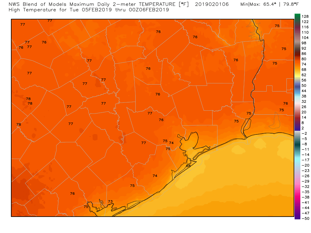
Fog will continue to pester coastal areas. Despite all of this, temperatures will be quite warm. Highs will be in the mid-70s and nighttime low temperatures will only bottom out in the 60s. If we see a little sunshine on Tuesday or Wednesday afternoons, it is very possible that some of us top 80 degrees. We shall see. I’ve seen a lot of folks say online that “it’s too early to be this warm!” And while I agree with you, statistically speaking we are all wrong. Over the last 30 years, Houston’s typical first 80 degree day has occurred on February 2nd, so it would be very much around what has been normal for us since the 1980s.
Our next cold front is penciled in for Thursday. It should have a period of widespread showers and storms before sharply colder air moves back into the area to close out the week. The roller coaster ride continues. We will update you regarding this on Monday.
If you don’t like the weather in Houston wait a day or two, it will change……..unless it is June, July, August, or September.
I really enjoy reading you each daily. I’ve learned a lot more about what weather. During a ”’slow” time, would you consider getting into some of the nitty-gritty of forecasting?
For instance, I see something like “There will be about a 20 to 40 percent chance of showers or a thunderstorm each afternoon” and I wonder how do you come up with percentsges. Is it each meteorologist on their own, or is there a set of guidelines that recommend “with x of y: 20 percent; with x+15 of y: 40 percent”? Or at what point does good go from patchy to dense? I’d love to learn more about the criteria for for some of these specific determinations.
It would appear that weather forecasting has become more accurate, SCW included.
http://science.sciencemag.org/content/363/6425/342