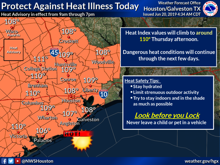
Good morning. Northern parts of the metro area may be clipped by fast-moving thunderstorms this morning—Conroe and areas north—but by far the biggest story of the day will be heat. The National Weather Service has issued a “heat advisory,” indicating that the heat index will reach 106 to 111 degrees. This essentially means that the temperature in the shade, when factoring in humidity, will feel much warmer than the actual temperature in the mid- to upper-90s. If you’re in the sunshine, the effect will be even more pronounced.
Thursday
Aside from the heat, and partly sunny skies on Thursday, southerly winds may gust up to 20 mph across the area, reflecting higher pressures to the south and lower pressures over the continental United States. These winds are not reflected in the heat advisory temperature above, but may provide some limited cooling despite the high humidity today. All in all, however, it will be a hot summer day in Houston, with highs ranging from the mid- to upper-90s. The other notable factor will be nighttime temperatures that likely don’t fall below 80 degrees on Thursday night or the next few nights.
Friday
This will be another warm and windy day, although highs probably will top out in the lower to mid-90s. Skies will be partly sunny.

Saturday
The first half of the weekend looks similar to Friday. We can’t entirely rule out a few scattered showers, but for almost everyone this should be a good day for outdoor water activities with a fair amount of sunshine and highs in the low- to mid-90s.
Sunday, Monday, and beyond
The forecast for the latter half of the weekend is a bit more tricky to parse out. A combination of weakening high pressure and the likelihood of a storm system in north Texas mean rain chances for the Houston region should go up beginning on Sunday, particularly for areas north of Interstate 10. That’s not to say forecast confidence is high, but I do think we will see healthy 50 percent rain chances on Sunday and Monday, with a lot of the area seeing perhaps 0.25 to 0.75 inches.

Frankly, the rain should be welcome, as high pressure appears likely to build again during the middle of next week, and send temperatures back into the mid- or upper-90s with lots of sunshine.
AC sweepstakes reminder
We’re now 10 days into our AC sweepstakes with Reliant. You can learn more details about the contest here—Reliant is giving away one complete AC system to Houston-area readers in July, and one in August. You (or a friend or family member) can enter here.
It is truly disgusting outside. I thought it was September for a minute.
As an asthmatic it would be really helpful for forecasts to include an air quality update if possible, especially with the African dust returning. Thanks! Love this site.
My allergist told me to just stay inside.
So I’m wondering if we’re going to have rolling brownouts with this extreme heat.
I wish plants would keep their private life, just private. Between the high pollen alerts, the Saharan dust, and the heat, those of us who suffer from allergies are miserable. The air quality forecast for today is PM 2.5 as moderate, PM10 is good, SO2 good, Ozone is goodCo and NO2 also good.
Can you enter the AC contest more than once?
I guess I don’t understand the “feels like” thing, by which I mean a) it seems like TV weather folk are calling it a heck of a lot higher than a few years ago given similar ambient temps, and b) I played golf today (9am to 1:30pm) in an area being called as 108 and it wasn’t that bad at all, not even close to feeling like 108.
Is there a revised formula being used? Sure seems so to me.