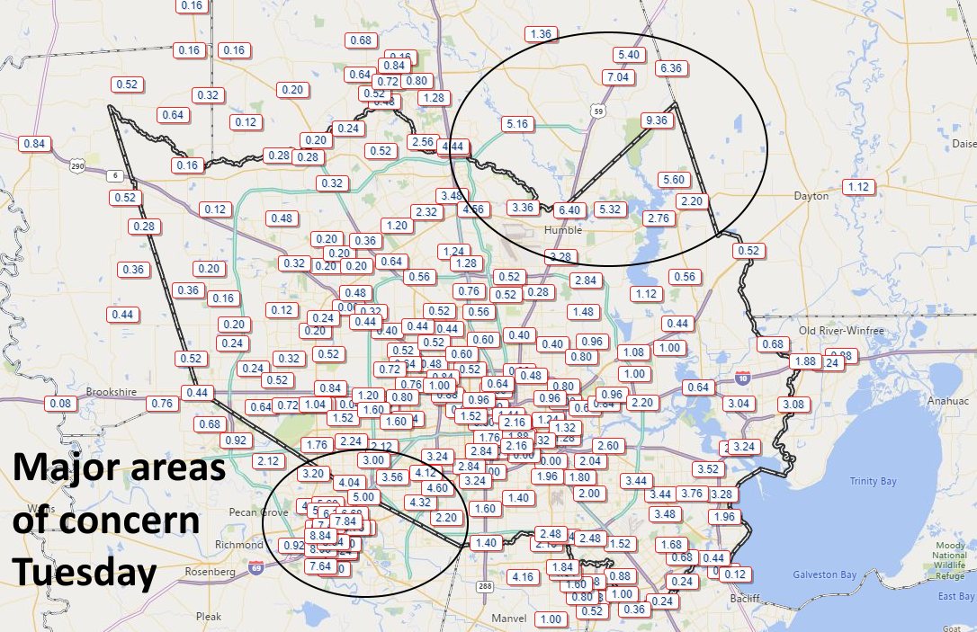
Earlier, we posted that we expected the heavy rainfall to wane between 6pm and 9pm this evening. Unfortunately, the storms have sustained themselves as the sun has gone down and continued to pile on rain totals—especially to the southwest of Houston in areas such as Sugar Land and Richmond. Regions there have now recorded 8 to 10 inches, nearing the exceptional amounts recorded in Humble and Kingwood earlier today and this afternoon.
So what happens now? With the sun now falling below the horizon, the rain cooled atmosphere will have less energy to sustain itself, and from a pure physics point of view, these heavy rain showers really should really ebb over the next 3 to 6 hours. But it is hard to have overly much confidence in this forecast given how much we’ve missed already today. We’re hoping for a break later tonight and perhaps Wednesday morning.
Where does this leave us? Quite frankly, we didn’t anticipate that the rains would be as intense as they were today. Certainly, we didn’t expect 10 inches of rain for any part of metro Houston, nor the need for high water rescues as are presently ongoing in southwest Houston. Yet here we are on the first day of a multi-day event, with soils now thoroughly sodden; some bayous near bank full; river concerns; and more.
Forced to guess, I’d say we’ve got two more major rounds of storms to worry about after this evening. There likely will be widespread showers on Wednesday night and Thursday, and then some kind of mess on Friday and Saturday. If those rounds are as bad as we’ve had today, then we’re going to see a much worse situation than now, but I don’t think we can quite say that yet.
We’ll be back with a full report in the morning.

Thanks for keeping us updated. Especially since we all how exacting weather forecasting is. NOT.
Thanks so much for this update Tuesday evening! Really appreciate all of your hard work.
I appreciate your reports. All this rain, thunder and lightning make me anxious. I hope it stops soon.
This is scary! We live in Del Webb Sweetgrass in Richmond which was evacuated during Harvey. The water then was no where near as high as it is now.
https://www.harriscountyfws.org/ is looking a little overwhelmed–the data isn’t updating, perhaps?
Thanks Eric for the good work and keeping us up to date.
I appreciate the updates.
As always – Thank y’all for your diligent and honest reporting.
Now, I dislike when you draw circles around my home. Please make it go away :-).
You know, in the last eight years, the metro area’s population has risen by over an estimated one million people. The continued development to accommodate all these residents has been wildly misguided at best, and blatantly negligent at worst. I’m living in Meyerland and watching so many new homes go up here with concrete slabs covering the entire floor span of the crawl space; how could any of this be permitted by the city? Someone in leadership in the city and county needs to accept responsibility and come up with a development plan that balances a growing population with the debilitations of our topography. If local officials can’t make the tough calls (ie eminent domain within 250 ft of a bayou bank), then someone from the state or federal government needs to step in and say enough is enough. A spring time thunderstorm event should not lead to this recurring drama. We may have gotten more rain than expected, but this is not an unprecedented event for Houston.
Since 2pm my area (El Dorado and Beamer) we have received over 5″ of rain much of that 3.75″ between 7:30 and 9:30pm. The rain is coming down again
Thank you for your hard work Erik/Matt. will be looking for your morning report!
As of 10 PM 4.8″ by Ellington Field. Heck of a drive home from inside 610 at 8:30 tonight. Coming down in sheets from just north of BW-8 with ponding water on the side streets.
Live by the motto: Just because you didn’t flood during [blank] event. Does NOT mean you won’t flood during the next event.
Looks like last night was a solid Stage 3 flood according to yall’s ranking system.