By several measures, Tuesday’s rains were exceptional for parts of the Houston metro area. According to the Harris County Flood Control District, one gauge in Sugar Land recorded 5.16 inches of rainfall in 1 hour and 15 minutes, and multiple other parts of the city saw rainfall rates nearly that extreme, which will quickly overwhelm the capacity of urban roadways. Tuesday’s commute was an absolute mess. Moreover, unofficially, an estimated 400 homes flooded in Kingwood. The Brazos River at Richmond has already reached a minor flood stage. Because of the unexpected intensity of Tuesday’s precipitation, and the potential for more heavy rainfall over the next four days, we are raising the expected impacts from these storms to Stage 3 (out of five levels) on our new flood scale.

Fortunately, the storms finally died down between 9pm and midnight on Tuesday, allowing the area a reprieve during the overnight hours. This allowed several creeks and bayous near the tops of their banks to begin receding, although many remain higher than normal. So let’s discuss what happens next.
Wednesday
The unstable, very moist atmosphere that produced widespread heavy rainfall on Tuesday more or less remains in place today, and this should fuel at least some scattered showers and thunderstorms throughout the daytime in the city. We do not believe these storms will be as widespread as on Tuesday, but certainly with some of the more slow-moving systems some areas could pick up a quick 1 to 3 inches of rainfall. Overall, however, most of the city will probably receive less than 1 inch of rain today.

Our other concern stems from an upper-level disturbance and cold front now bringing storms to west and central Texas. This should move toward the region this afternoon and evening, bringing with it the potential for severe thunderstorms toward Houston. While most of the action will probably remain north of Houston, NOAA’s storm prediction center has brought the region where there is a “slight” chance of damaging winds, hail, and potentially tornadoes down to about the Interstate 10 corridor. This will be worth tracking.
Basically, today is a day of “potential.” The unstable atmosphere could produce a very wet day, almost like Tuesday for some areas. Or showers could be much more scattered in nature—our high resolution models have performed so poorly of late it’s just hard to say for sure. Similarly, the upper-level disturbance could remain far enough north of the metro area such that it will not cause major problems—or not. We’ll be monitoring throughout the day for you.

Thursday
At this point, we’d anticipate that whatever storms develop on Wednesday will again, to some extent, wind down Wednesday night. That leaves the question of where the best conditions for storms will set up Thursday. At this point, our best guess is they will develop somewhere to the south of Interstate 10, perhaps near the highway, or perhaps much further south. Frankly, it is hard to have too much confidence in any forecast, but certainly Thursday into Thursday night will likely be another wet period for some part of the Houston region.
Friday and Saturday
Unfortunately, our moist atmosphere isn’t going anywhere for the next several days. Forecast models have been suggesting that a somewhat stronger disturbance will push into the area later Friday and Saturday, likely leading to one final round of widespread heavy rainfall. As far as timings and bullseyes for the heaviest rain, sorry, we can’t help you there yet.
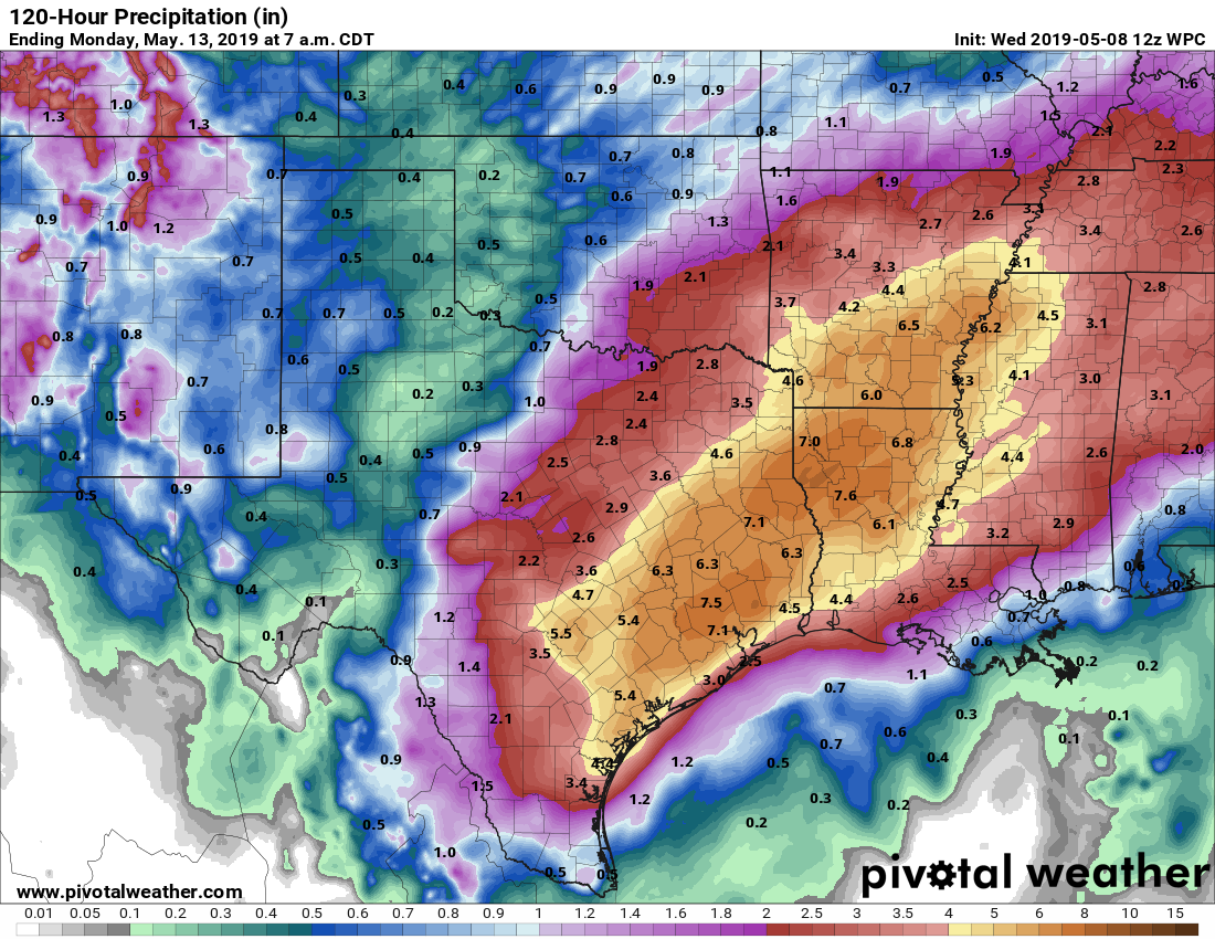
Overall, the National Weather Service is forecasting additional rainfall totals of 5 to 8 inches this week, with isolated areas of 9 to 12 inches through Saturday. These totals offer a reasonable guess, and are probably manageable for most areas if spread over the next four days. Unfortunately, for some locations (such as Kingwood and Sugar Land on Tuesday) these kinds of rains in May, with this kind of a moist atmosphere, often burst forth in just a few hours. So we expect more problems, and we’re going to be here with you throughout the next four days to try and stay on top of things.
Sunday and beyond
We still expect the rains to end by Saturday night or Sunday morning, giving us at least a day or two’s break from this, and some sunshine. It is not clear how long this will last, however, and given the uncertainty of the next four days, it seems like folly to try and confidently predict anything five to seven days from now.
I hope today’s storms do not live up to their full ‘potential’.
Thank you SCW! Straight to the point always.
Sure appreciate the hard work y’all do to keep us informed.
FBISD on a two-hour delay today (probably announced after some kids already were on the way to school). Other school districts up north are closed. The districts are assuming they’ll be okay the rest of the week, but that seems to be a big leap of faith to take.
Difficult for me to see today being as bad as Tuesday, but yeah.
My son is driving from Amarillo to Houston. Would he be better off taking the long route through San Antonio and coming into Houston from the west? Or will he be ok coming through Dallas? Or is there just no way to tell?
Thanks for all of your good information.
Depends on timing. If he’s leaving this morning; San Antonio is probably better.
If its this afternoon or later, probably not too much difference.
Thanks Eric. He’s on the road now to San Antonio. Thanks again for all you do.
Thanks, as always, for providing factual information without the anxiety-producing hype. I appreciate all you do to keep us informed.
You guys really are the best and provide hype free information to those that want real news. Thanks for all you do for H Town
What are your thoughts on flights arriving around 2:30pm today to iah? Will they be impacted much? Thanks
Hard to say. I’d probably feel OK about it.
what about tonight? i have an elderly relative flying in at 9pm to IAH
It is really interesting to look at the rainfall totals outside the Beltway and inside. North of I-10, but inside the belt didn’t seem to get much. Areas south of 59 look like they got hammered. You guys do great work dealing with the uncertainty of May rains!
Have family landing in IAH at 850am on friday. Think their could be issues or cancellations?
Also are there chances we don’t get hot this weekend? In Tomball/Woodlands area
There could be issues Friday morning, but it’s impossible to say more than that.
Highs this weekend are unlikely to rise much above 80 degrees.
Any thoughts on why the high res models are performing poorly? Weather so off typical patterns that their logic isn’t handling well or the old problem garbage in garbage out? Hope it straightens out by June 1. 🙂
Planning to drive up to Lubbock Friday morning and come back Saturday. Do I need to look at postponing until Monday?
How do you expect the area around Old Gslveston Rd and Edgebrook to do. I am not sure where we are located on the rainfall map. It seems like we received a lot of rain last night,
Thank you both for your continual hard work. I sing the praises of my “go-to guys” all the time. I am especially appreciative of your email updates during the day yesterday. We’re high and dry in Tanglewilde/Westmont (Gessner @ Westheimer).
I got big plans Friday evening in downtown Houston with 8 of my friends, and might even shoot off a few fireworks. Do you think the lightning will “strike”?
Been following this post for years, this is the best comment ever!
This is great!!!! Go Astros!
This is amazing.
does katy need to evacuate
I was wondering the same.
I assume so.
Yes. The answer is always yes…
We got the heaviest rain & lightning between 9pm & midnight here in Texas City! Around .75” around 8pm, then finishing up with 2.1” at midnight.
@Justin V just go ahead with your plans and stay out of the pipe.
Ok, I think I have the new stages figured out. Yesterday, which should have been a Stage 2, was Stage 3. So, if we can expect Stage 3, I will expect and plan for Stage 4. Preparing to evacuate.
Got it!
What about Friday for UH College Graduations, and Saturday Graduation Parties. I know I know that’s the last of our worries but just want to ask for my mom who is planning my youngest sisters graduation thanks.
You da man Eric!
Eric, when will you and Matt provide the next update?
So you’re asking for an update on the timing of the update?
Several homes (maybe 40 to 50) were flooded in Greatwood subdivision in Sugar Land on Tuesday. A couple of my fellow homeowners are reporting 17 inches of rain over 3+ hours.
NOAA is saying 5-8″ widespread, with double that (10-16″) in certain locations. Will this be able to be pinpointed? 16″ on top of the 10″ from yesterday will cause severe flooding.
Eric still gives the BEST, MOST SCIENTIFIC, AND SATISFYING weather analysis
throughout the years!
You guys are the only weather news I trust.