Happy Friday. It’s been a pretty nice week overall in Houston, and we have another couple nice days coming up. As Eric and I have been discussing, this nice weather has continued to march Texas into drought. November’s 0.50″ of rain in Houston ranks it as the fourth driest November on record for our city. And 90% of that rain fell on November 1st. Things have really just shut down post-Harvey, and we continue to see drought expanding, now evidenced around Houston on the weekly drought monitor report issued Thursday.
Updated Drought Monitor showing moderate drought increasing in coverage across Central Texas and the middle Texas coast. 35 percent of the state is now shown to be in some level of drought. Rainfall over the
past 60 days has generally been below 50 percent of normal. pic.twitter.com/VPF533tGBR— Bob Rose (@BobRoseTX) November 30, 2017
So, yes, while it’s tough to really say it, we actually really do need rain now. And we should get at least a little of it Sunday.
Today & Saturday
Both days look stellar to kick off the weekend. Expect sunshine both today and tomorrow with daytime highs in the low to mid-70s on average, with nighttime lows in the mid-50s tonight and upper-50s to around 60° on Saturday night. I wouldn’t rule out some patchy fog Saturday morning, especially south and east of Houston.
(Space City Weather is brought to you this month by the Law Office of Murray Newman)
Sunday through Tuesday
The weather starts changing on Sunday with increasing clouds and at least scattered showers in the area. I suspect we’ll see a few garden variety thunderstorms on Sunday also. Downpours will likely be hit or miss, so expect around 0.25″ to maybe 0.50″ of rain on average. A few places may not see much rain at all, but I also wouldn’t be shocked if some downpours can produce an inch or so in a few other spots around the area. Again, we need the rain.
Onshore flow will pump back in humidity and warmer temps Sunday and Monday into Tuesday. Expect at least a few scattered showers or a thunderstorm Monday also, but most places shouldn’t see too much. Temperatures will peak around the mid-70s Sunday and just about 80 degrees on Monday. I wouldn’t be shocked if we see areas of fog, especially near the coast as we go into Monday or Tuesday mornings.
Tuesday is a challenging forecast because it will hinge on the timing and speed of the incoming cold front Eric’s been discussing all week. Model agreement has increased a little bit with regard to that. Expect hit or miss showers or storms as the front comes through Tuesday afternoon (probably nothing serious). We’ll turn much colder behind it with falling temperatures into the low 50s or upper 40s Tuesday night. We won’t clear out sharply behind this front like we have others this autumn. Expect clouds and rain showers to linger through Tuesday night.
Beyond Tuesday
In the immediate wake of the front, expect clouds, light rain, or showers to continue on Wednesday. Temperatures may struggle to get out of the mid-50s, depending on how long the clouds linger. We should see clearing late or by Thursday though.
Again, as Eric has discussed this week, this wintry pattern will settle in over Texas. To be fair, this doesn’t look like a tremendous shot of cold in the US initially, despite a really impressive pattern 20,000 feet over our heads across North America and much of the Northern Hemisphere.
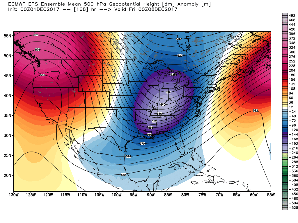
But, this will likely lead to some persistent cooler temps in Texas, something we haven’t seen much of the last couple winters. It still appears we’ll have several days of 50s or 60s for highs with chilly nights. I wouldn’t be surprised if much of middle December is characterized by some ups and downs in our temperatures, perhaps down more often than up though. We’ll keep you posted.
Quick note: We just want to thank all who donated to our annual fundraiser and/or purchased t’shirts to support Space City Weather. We’ve always had some wonderful and fiercely loyal readers, but the support from and growth in our readership since Harvey has been incredible. We are thankful for your support, and we’ll continue to do our best to serve and inform you as we move ahead!
Thank you so much for all that you guys do! Love your weather updates! Can I still donate?
Matt/Eric…the success of your fund-raiser speaks volumes about your product and service…congratulations…best to you and family as we roll through the end of 2017…
Can I still buy a T-shirt? Is there a link you can share?
After Ike, Houston went into an extended dry period, leading to the major drought. It looks like post Harvey is starting out the same way.
I’m scared of those thunderstorms, he’s mentioned. I’ve seen what even a non-severe storm can do to Houston, esp. in terms of lightning and power outages.
How can there be a drought when 2017 has been the wettest year ever? One or two months of low rain can then suddenly turn the tide and plunge the region into a drought? I am glad to see that the cool, winter weather is not really cold. 40s, 50s, 60s may be chilly or cool but is rather typical for December, January, and February. Just as long as it doesn’t get down around 30. At the beginning of this year, there was a cold snap that gave my plants a big setback and froze the sink pipe.
I’m in Sugarland and the downpour at 4:20 in the afternoon sure seems like more than half an inch of rain!!!!