In brief: Houston faces one more ‘hot’ day before temperatures begin to moderate. There is a low-end chance of showers and thunderstorms today and Thursday, but we are highly confident in widespread showers on Friday. The weekend looks considerably colder.
The 90s are back
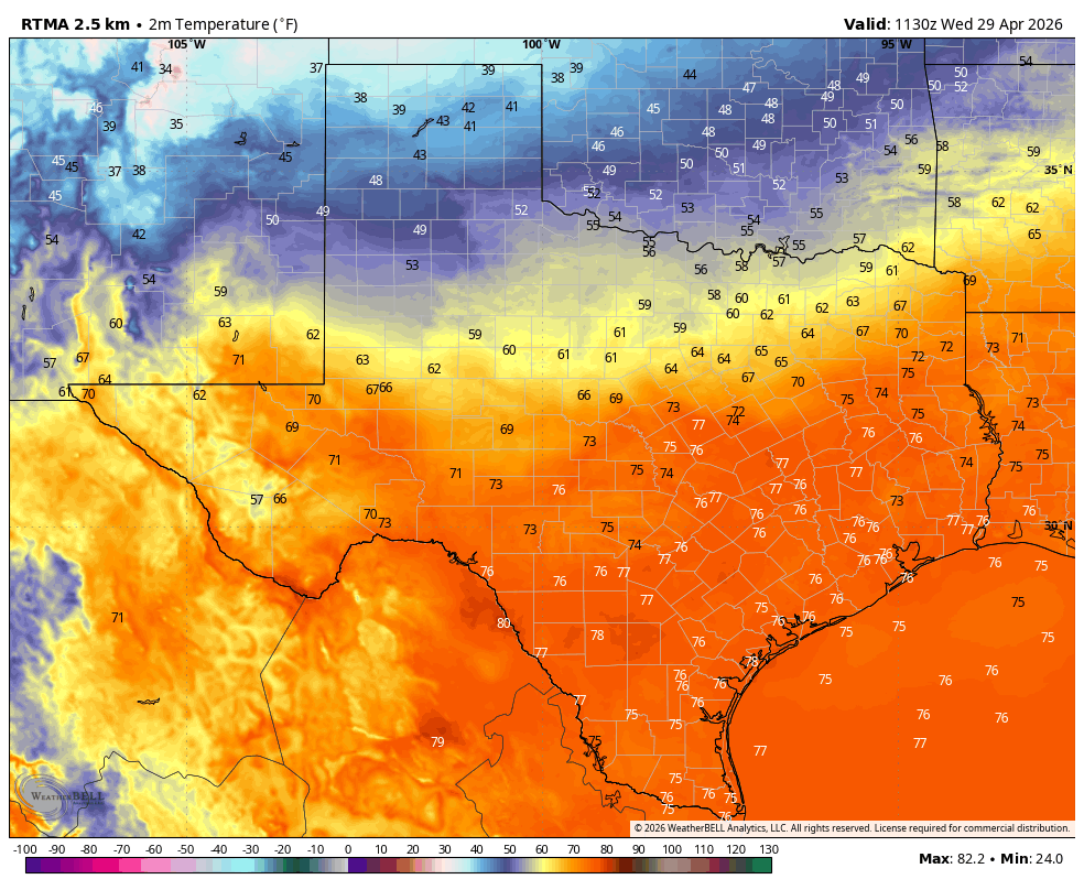
Houston officially hit 90 degrees for the first time this year on Tuesday, reaching the mark shortly after noon at Bush Intercontinental Airport. As we noted on Monday, this is only a few days earlier than normal for such a temperature, so it’s not anything to be too concerned about. However, it still felt pretty warm, and served notice for the fact that we are only about a month from the start of June. We know it is not yet June because a fairly strong cool front will arrive on Friday, driving our low temperatures back into the 50s.
By the way, if you missed our Q&A yesterday, there were a lot of good questions, and Matt and I put a lot of effort into providing some answers. Be sure and check it out!
Wednesday
It is really warm and muggy this morning, with lows generally in the mid-70s. Overall conditions today should be similar to Tuesday in terms of heat and humidity, with highs likely reaching about 90 degrees in Houston and points north, and slightly cooler conditions near the coast. The question is the potential for storms as a weak front sags into the region.
Generally, I think chances are best for showers, thunderstorms, and severe weather along and north of Highway 105, so for locations such as College Station, Huntsville, and Livingston. Even for these areas the overall chance is fairly low, but it is something to watch out for. Later this afternoon it is possible that storms move further south, into the city of Houston itself. This is a low-probability, high-risk scenario in that it is unlikely to happen, but if storms do break out later today they could be severe.
Low temperatures tonight will drop into the lower 70s.
Thursday
This will be a mostly cloudy day with highs generally in the mid-80s. Humidity will still be pretty high. There is perhaps a 30 percent chance of showers and thunderstorms. As slightly cooler air drifts in, overnight lows may drop into the 60s.
Friday
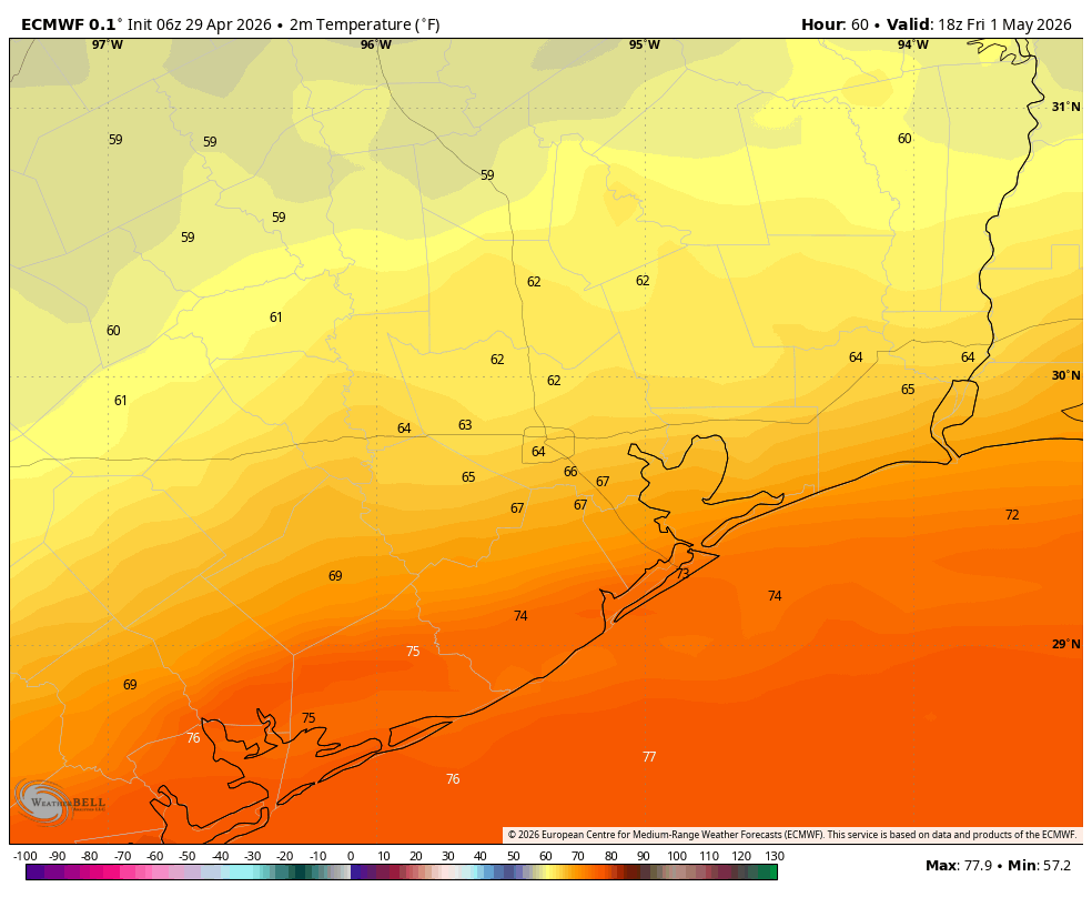
This is the prime day for showers as a front moves into the region. Let’s start with temperatures. For areas north of Houston, highs may top out at around 60 degrees behind the front, whereas areas along and south of Interstate 10 may reach the upper 70s before cooler temperatures arrive during the afternoon or evening hours. Overnight lows will drop into the 50s by early Saturday area wide, so that will be a big change.
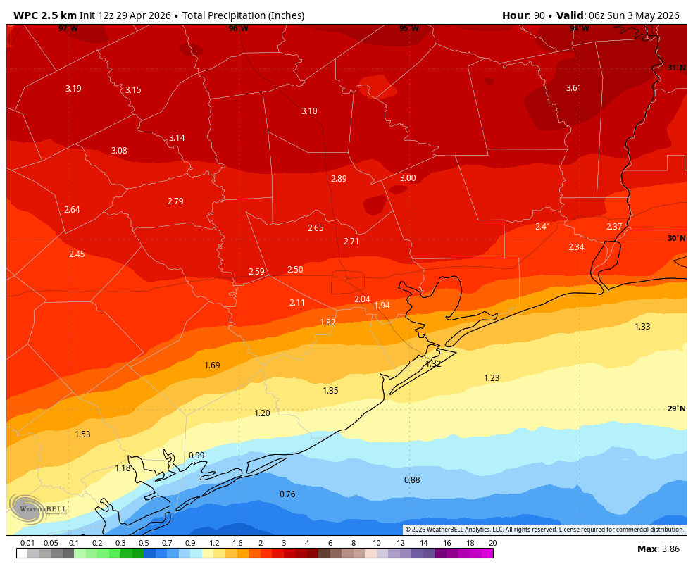
And what of rain? Basically from the wee hours of Friday morning through Friday evening there will be a healthy chance of showers and thunderstorms. We cannot rule out severe weather like hail and damaging winds, but the biggest threat appears to be heavy rainfall. Most of the region should pick up 1 to 3 inches, from Huntsville all the way to Galveston Island. For a lot of Houston this will be a helpful dousing of rainfall with summer right around the corner. But I’m concerned about the potential for street flooding. Matt and I will assess the need for a Stage 1 flood alert as some locations will almost certainly see higher amounts.
If you have outdoor events planned for Friday or Friday evening you absolutely need a backup plan because we are highly confident in widespread rain showers.
Saturday
The rains should clear out on Friday night, leaving us with breezy and cooler conditions on Saturday morning. Some locations, particularly near the coast, may see gusts up to 30 mph later on Friday night and through Saturday morning. These winds should back off a little, with clearing skies as temperatures warm to the lower 70s on Saturday. Lows on Saturday night should drop into the mid-50s in Houston, with some inland areas reaching the upper 40s. As noted above, this front will pack a nice punch for late spring.
Sunday
This will be a splendid day, with sunny skies, light winds, low humidity, and highs in the 70s. Sunday night will be a few degrees warmer than Saturday night as the onshore flow begins to return.
Next week
Most of next week should be warmer, in the 80s, with returning humidity. A weak front later next week may bring some showers by Thursday or Friday.
