In brief: With today’s update we are issuing a Stage 1 flood alert for Friday in the Houston area. This means mostly minor impacts, but we cannot rule out some street flooding. The weekend looks much cooler, with sunny skies and generally very pleasant weather.
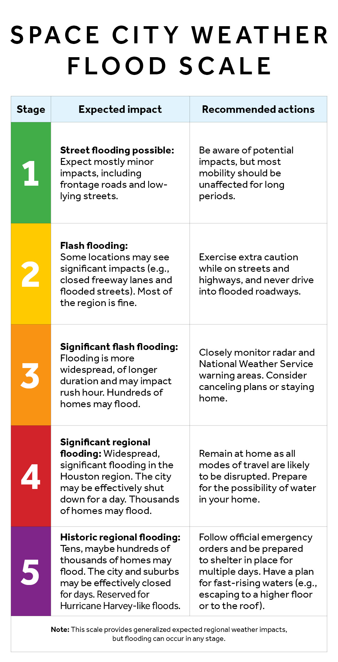
Stage 1 flood alert
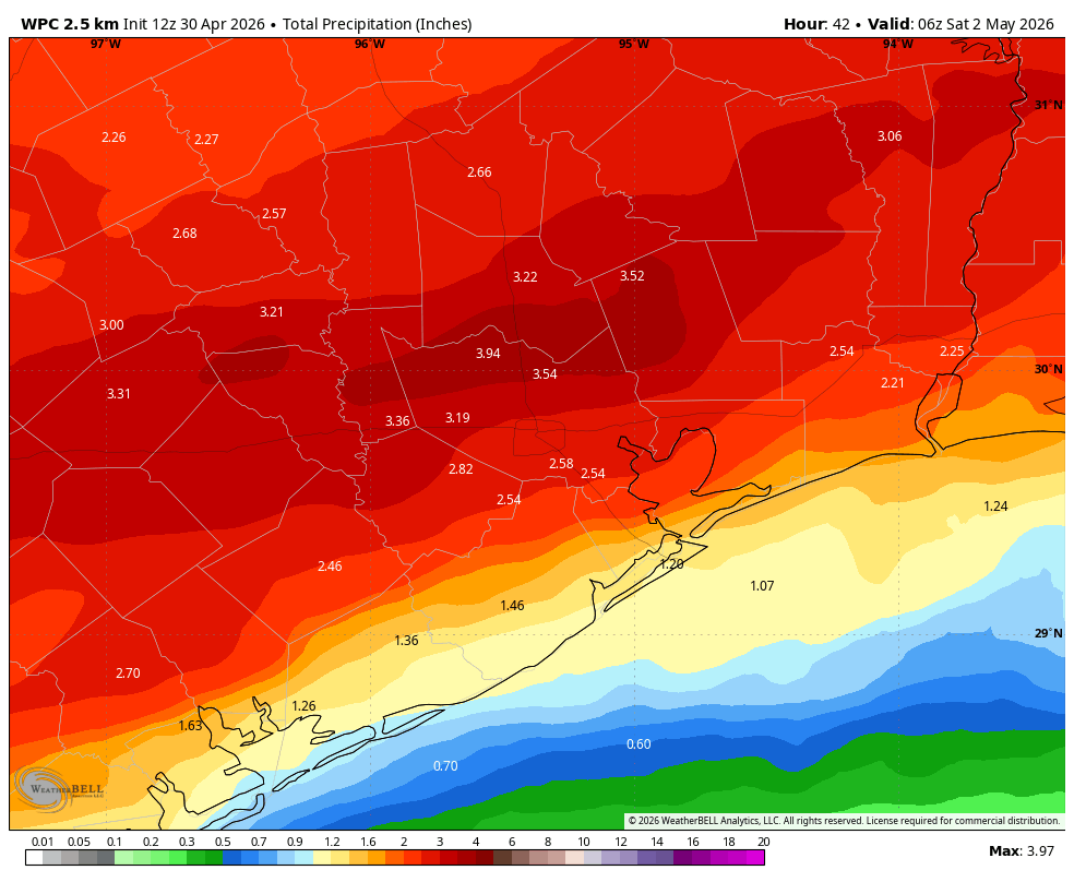
We are not expecting widespread flooding issues on Friday, but there is clearly the potential for heavy rainfall across the Houston metro area. In terms of timing, the most likely period will be from late Thursday evening through late Friday evening. There is the potential for impacts both during the morning and evening commute on Friday, not to mention school pickups and after-school activities. Most of Houston should pick up 1 to 3 inches over the course of the 24-hour period, which is totally manageable. However there are likely to be spots that pick up more than this, with the potential for isolated totals of 3 to 5 inches. For this reason we are instituting a Stage 1 flood alert for all of Friday. We expect rainfall potential to fall off quickly by Friday night, midnight. Saturday looks fine, with clearing skies.
Thursday
Houston reached 88 degrees on Wednesday, but I believe we’re done with the very warm weather for now. Skies today will be mostly cloudy and this should help limit high temperatures for most locations in the mid-80s. An initial push of slightly drier air should arrive this afternoon, allowing low temperatures tonight to fall into the 60. In terms of rainfall, we will see the potential for scattered showers, and perhaps a few thunderstorms today and into this early evening. However, there won’t be anything too special about this activity. We’ll start to see increasing chances for rainfall after sunset on Thursday and into the overnight hours.
Friday
The much discussed cold front will essentially stall over the Houston metro area on Friday, and this will serve as a focus for showers and heavy rainfall. (There is a very slight chance for severe weather, such as damaging winds and hail). There remains some uncertainty as to where the heaviest band of rainfall will set up, it could be along the Highway 59/I-69 corridor, or a little north or south. But we do feel like somewhere is going to see 2 to 4 inches, with higher amounts possible. Generally we expect most of the region to pick up 1 to 3 inches. This potential for rainfall will persist into the evening Friday before the front finally pushes off the coast.
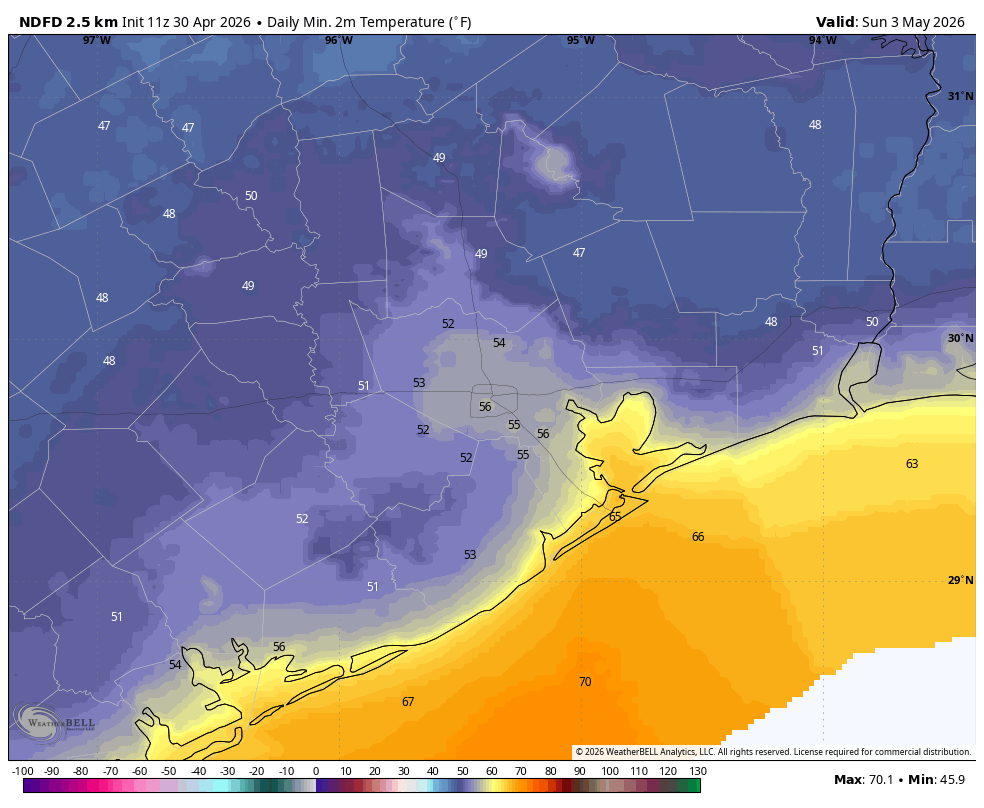
In terms of temperatures, I expect everyone to be in the 60s on Friday morning, with inland areas remaining there while coastal areas may warm into the mid-70s. By early Saturday the entire area will be in the 50s.
Saturday and Sunday
Although some clouds may linger on Saturday morning, we now pretty much expect wall-to-wall sunshine for the weekend. Saturday’s highs may peak around 70 degrees, whereas Sunday reaches the mid-70s. Friday night and much of Saturday will be quite breezy, with southerly gusts reaching 25 or even 30 mph (especially along the coast). These winds should die down by Saturday afternoon or evening, so Sunday looks placid in this regard. Lows on Saturday night should again drop into the 50s, with the potential for upper 40s for far inland areas. Both Saturday and Sunday will enjoy low humidity. This is a really nice cold blast for early May, so enjoy it before summer arrives!
Next week
We’ll warm back up to the mid-80s by the middle of next week before a weaker front may push into the region and bring some rain chances and slightly cooler conditions. We’ll see.
