Houston’s weather pattern remains more or less the same, and should hold through the weekend, as moderate high pressure (mostly) keeps a lid on afternoon showers. Rain chances look to go up next week as a “cold” front approaches and possibly even pushes through the region.
Thursday, Friday, and Saturday
Similar weather is similar. We can essentially expect repeat days of high temperatures in the mid-90s, and overnight lows ranging from the mid-70s (inland) to around 80 degrees (along the coast). A few isolated to scattered showers are definitely possible, including some heavier thunderstorms. We saw some of those on Wednesday in Pearland and League City, and there’s enough weakness in high pressure aloft that we should see some more over the next few days.

Sunday and Monday
More of the same, but with slightly better rain chances, perhaps about 30 percent of the area will see rain each day.

Tuesday and beyond
We’re continuing to watch the possibility of a cold front moving into Texas and possibly pushing all the way into the Houston area. It is always hard to have much confidence in cold fronts making it to Houston in August, as they typically don’t have that much support in the atmosphere. Moreover, even if the front makes it through, it won’t pack much of a cooling burst. Even so, the prospect of a front in August is tantalizing. One effect it will probably bring is better rain chances, perhaps by Wednesday or so, but we can’t pin those details down yet with any confidence.
Tropics
The National Hurricane Center has begun tracking a tropical wave in the southern Atlantic Ocean, giving it a 20 percent chance of becoming a tropical depression or storm over the next five days. The system is far enough south that it hasn’t really been inhibited by all of the Saharan dust, but conditions aren’t great for further development over the next several days.
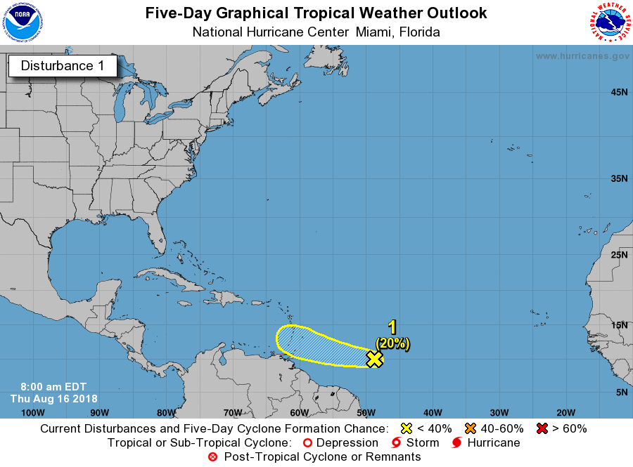
Expect to see a fair amount of news and social media coverage of this system in the next day or two, as from a tropics perspective there has really been nothing even remotely threatening in the Atlantic for months. The reality is that right now there is very little reason to think this system is a threat (there is essentially zero support for development in most forecast models), but as ever we want to watch the tropics closely in August and September.
Barbados might receive a bunch of rain this weekend. Cue hysteria in 3… 2…
1″ at our home in Friendswood yesterday — happy to have some rain!
These August “cold fronts”. Are we talking knocking the morning temps down a bit or just more or less drier air?
1. Rule out volcanic eruption locally
2. Things in common….Houston