The last couple days have featured a handful of showers in the area, but not much coverage. That said, those that have been fortunate enough to see rain have seen a fair bit. The next few days will likely see that as well, but your odds of seeing rain on any one day are rather low. Next week’s forecast is sitting out there like a piece of chocolate cake, daring you to take a bite. Tantalizing is the right word here. Let’s walk through things.
Today & weekend
We will see a lot of broken-record type weather this weekend, as Eric put it yesterday. It will be partly to mostly sunny and hot all three days. Look for high temperatures topping out in the mid-90s.
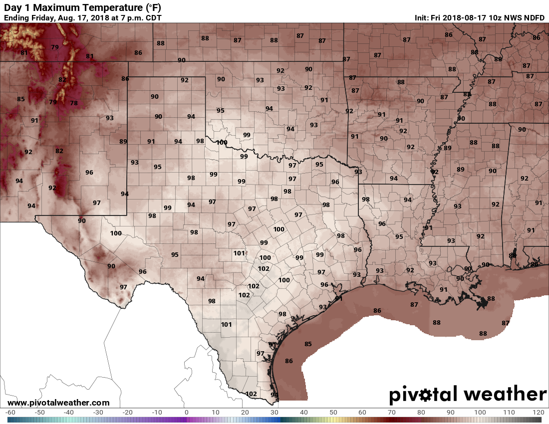
Morning lows will be low-80s at the coast to mid- or upper-70s in Houston. Yes, as noted above, you could see a shower, but truthfully, I would expect most of us are dry this weekend. Saturday may have the very slight edge over Friday and Sunday for best rain chance.
A heat advisory was issued on Thursday for Houston and points south by the National Weather Service. I would not be shocked to see that happen again today, with high humidity rolling in with the sea breeze off the Gulf, driving unpleasant weather. Regardless, do exercise typical late summer heat precautions over the next few days, especially in the afternoon.
Monday
At this point, Monday looks like an extension of the weekend, with a slight shower chance and high temperatures in the mid-90s. There may be a slightly better chance of showers or storms than the weekend east of the area toward Beaumont and Port Arthur.
Basically, typical August weather through early next week.

Rest of next week
I’m using the word tantalizing to describe what’s on some of the modeling for next week, because any chance you have at a front in August is a tantalizing opportunity. Let’s set expectations though: August cold fronts aren’t like the ones we see in winter. It won’t be much cooler behind a front this time of year, though you may be able to shave a handful of degrees off nighttime lows.
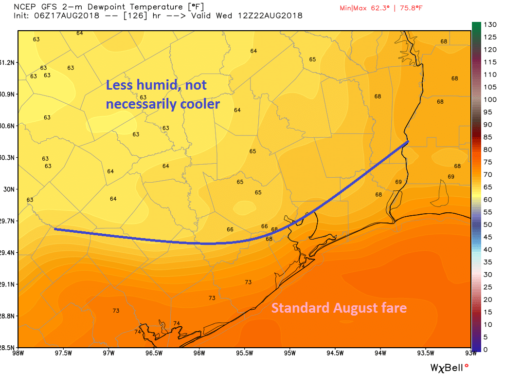
Where August fronts really help is with humidity. Any chance you have to turn winds offshore in summer helps cut off our giant bathtub to the south, at least for a day or two. That’s the hope. Models are still very borderline on what happens here, with the GFS more aggressive in bringing the front through than the Euro.
In terms of rain, with an approaching front, we should see increasing rain chances, regardless of whether or not the front is able to get all the way to the coast. Look for that especially later Tuesday and Wednesday. If the front can clear the area, rain chances will diminish for a time.
So as of right now, our two plausible scenarios for midweek next week are less humid (if the front clears) or wetter and cooler (if the front approaches but doesn’t clear). Both options are truly not bad ones for those of us seeking a brief break from the late August grind. We’ll have more on Monday.
Tropics
The disturbance east of the Caribbean islands, classified as “Invest 99L” looks very disjointed this morning.
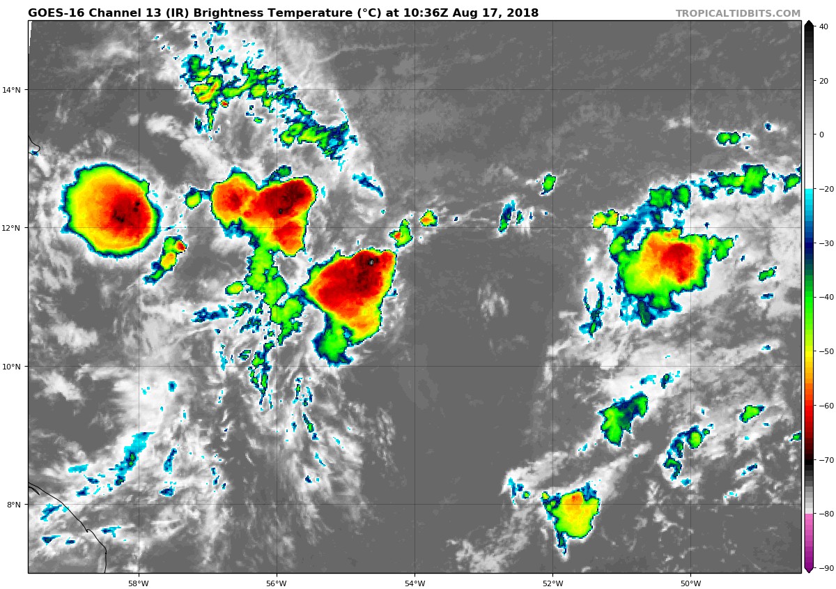
It’s still got a narrow window of potential to develop, but once it arrives in the Caribbean, it should find less than hospitable conditions. Wind shear isn’t as strong as it was a week ago in the Caribbean, but it’s still plenty strong enough to dissipate this disturbance, should it develop. In other words, this isn’t something to worry about.
Elsewhere, we continue to see very minimal signals for anything to develop over the next 7-10 days or so. I’d continue to watch the deep Atlantic in about 10 days for some lower-end risks, but I see nothing at all at this time for us in Texas to pay close attention to. Let’s hope this continues. We will keep you posted.
So, I’m confused….has yesterday’s broken weather pattern been fixed or not? Why do you call to fix your weather pattern anyway? Is it expensive?
Think of it as broken but on your favorite TV channel. We can call to fix it later. Anyway, remember what Bob Dylan said: You don’t need a weather man to know which way the wind blows.
Yup – One of the first music videos, if memory serves correct. Mid 60s.
On the news last night they spoke of 2 or 3 fronts pushing toward Houston. True or not.
Well, as you see from the post, there’s one that may or may not make it through. I can’t really tell you much about these other ones. But it is August and it is unlikely.
I will take Door No. 2 – – wetter and cooler, please.
Love reading the forecast from both on you guys. Thanks for giving us a source for some straightforward honest meteorology.
“Broken-record type weather.” Sadly, I’m old enough to understand the reference.