In brief: Smoke and dust creating a hazy situation around Houston this weekend will likely continue into early next week. But also a slight change will allow for some minor rain chances to return after the weekend.
The weather in Houston can only be described right now as very typical late June or July. It’s hot and humid but not overly so. We have already seen some Saharan dust, but we’re also seeing a lot of haze aloft that is almost certainly related to ongoing Western U.S. wildfires.
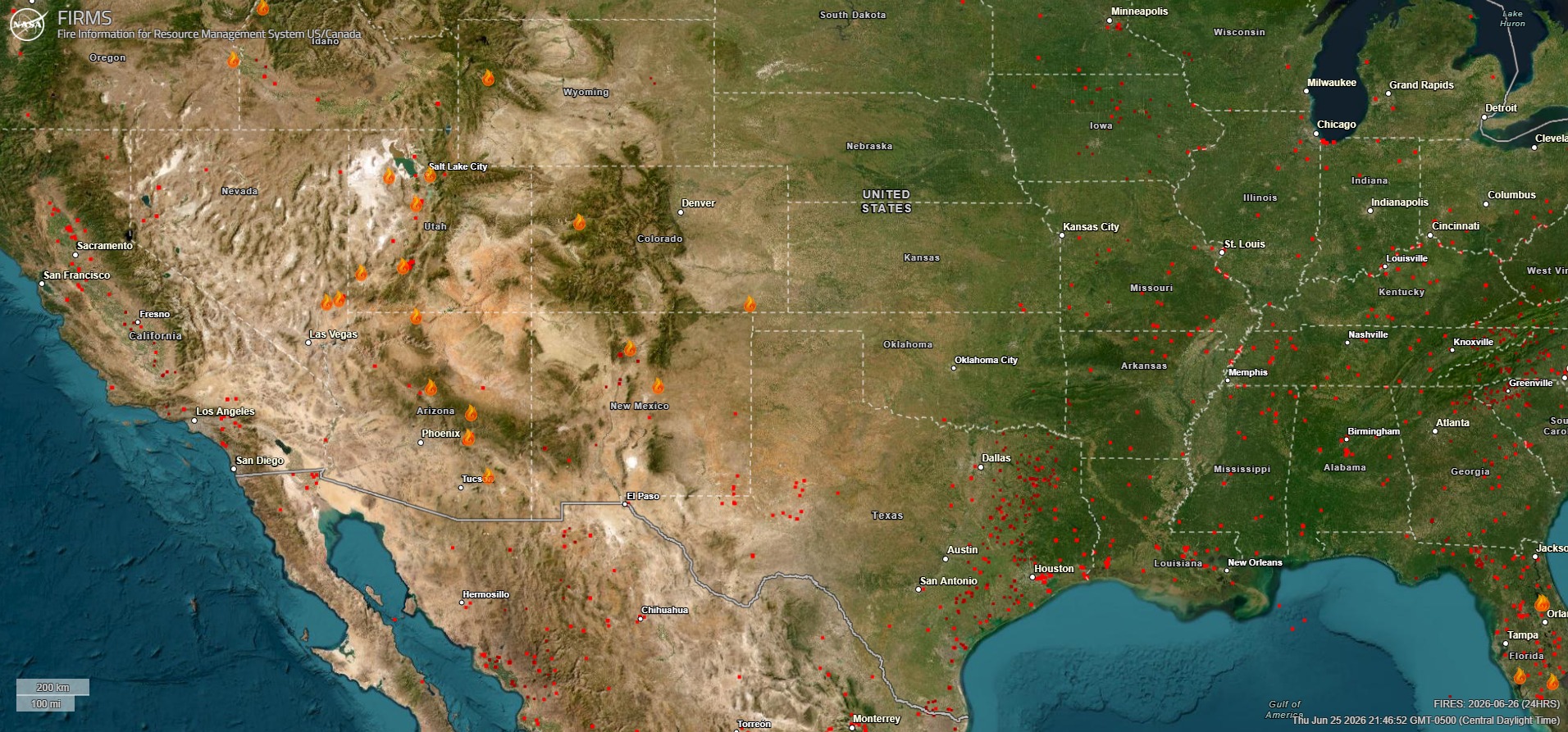
This acrid looking mix of smoke, dust, and haze will persist through the weekend, only accentuated by a burst of Saharan dust by later Sunday or Monday.
Today & weekend
Not a whole lot of change in things expected here, with sun, heat, humidity, and haze. Saharan dust thickens up a bit as Sunday progresses. Shower chances are minimal. That’s about it. We’ll keep it simple today.
Next week
As we head into Monday and Tuesday, a sprawling area of upper-level high pressure is going to establish itself over the Ohio and Mississippi Valleys, bringing a pretty hefty heat wave to parts of the Midwest, Mid-South, and East Coast. Houston will be positioned on the southwest periphery of that high pressure. For us, that does a couple things.
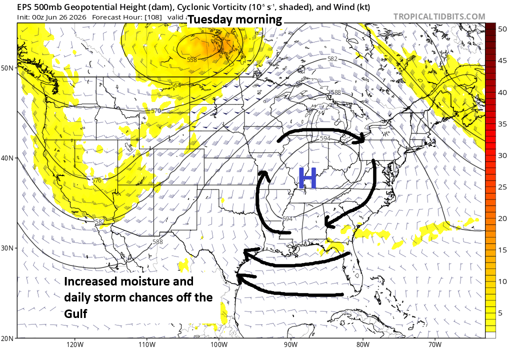
First, it should open the door to the Gulf a bit. This will allow for the typical splash and dash summer thunderstorms we get here in Houston to re-enter the picture by Tuesday or Wednesday. Second, it will allow for the Saharan dust plume to blow into the area early in the week. Smoke from the western wildfires should hopefully diminish some. Also, it means that if any tropical waves enter the Gulf, they could be pointed toward the Gulf Coast. By Wednesday or Thursday, that’s a possibility, and although development of any significance is not expected, it could help nudge up our rain chances a little for the middle to end of the week. Or it could mostly end up in Louisiana. Both are reasonable potential outcomes. We’ll watch this weekend to see how things go.
Either way, by our 250th birthday next weekend, we’ll probably see that Gulf connection back off a bit as high pressure shifts out of the Midwest, with somewhat hotter, drier weather returning to Texas.
Drought update
The rains of late have definitely done wonders for our drought situation in Texas. Most of the state is now free of drought, with the notable exception of the Panhandle and portions of northeast and interior central and south Texas. The last time the majority of Texas was free of “abnormally dry” or worse conditions was September of last year.
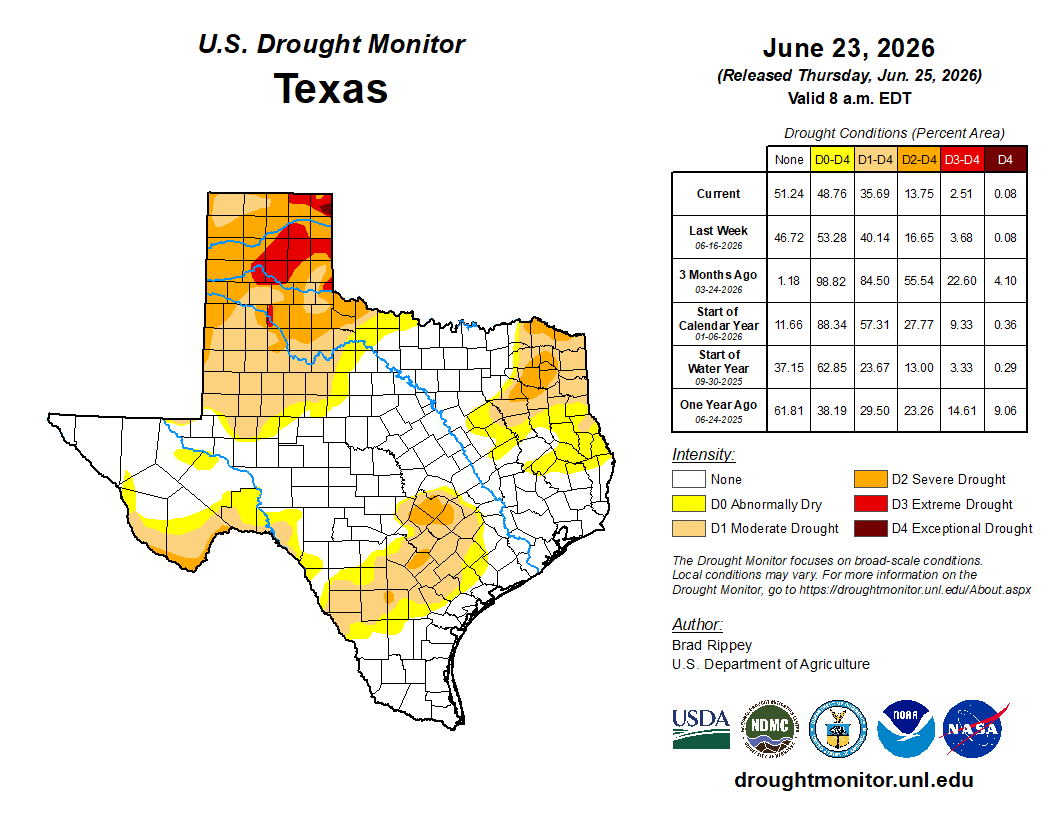
Lake Corpus Christi is about 33 percent full now, up from 14 percent a month ago. While Choke Canyon is still in very poor shape (below 10 percent full), the other reservoirs are picking up the slack and buying some time before what will hopefully be a wetter winter in South Texas. We shall see.
