Well, so much for the high pressure that was supposed to tamp down on rain activity Thursday. Despite the influence of a ridge to the west of the region, some pretty strong showers still popped up over Houston, dropping as much as 1.5 inches near the Waller-Harris County line Thursday. I think we’ll be in for a similar pattern this weekend in which perhaps only 30 to 40 percent of the Houston area receives rainfall in any given day, but those areas that do see showers could experience some briefly heavy rainfall. Welcome to the game of rainfall roulette.
Friday
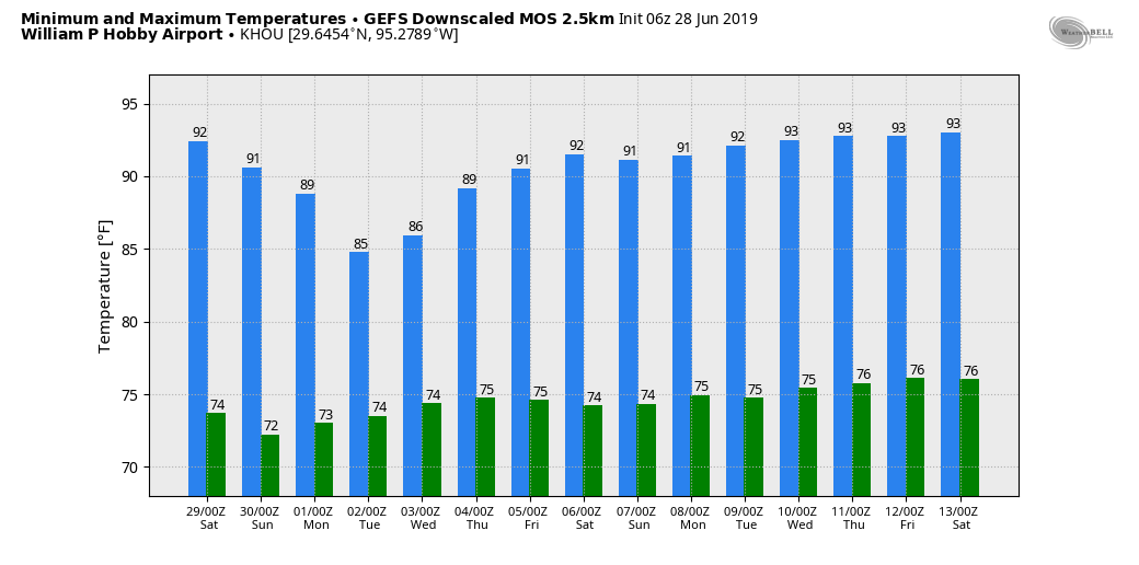
Mostly sunny skies this morning should allow temperatures to push up into the low- or even mid-90s by early this afternoon, and this will be warm enough to help generate some scattered showers and thunderstorms.
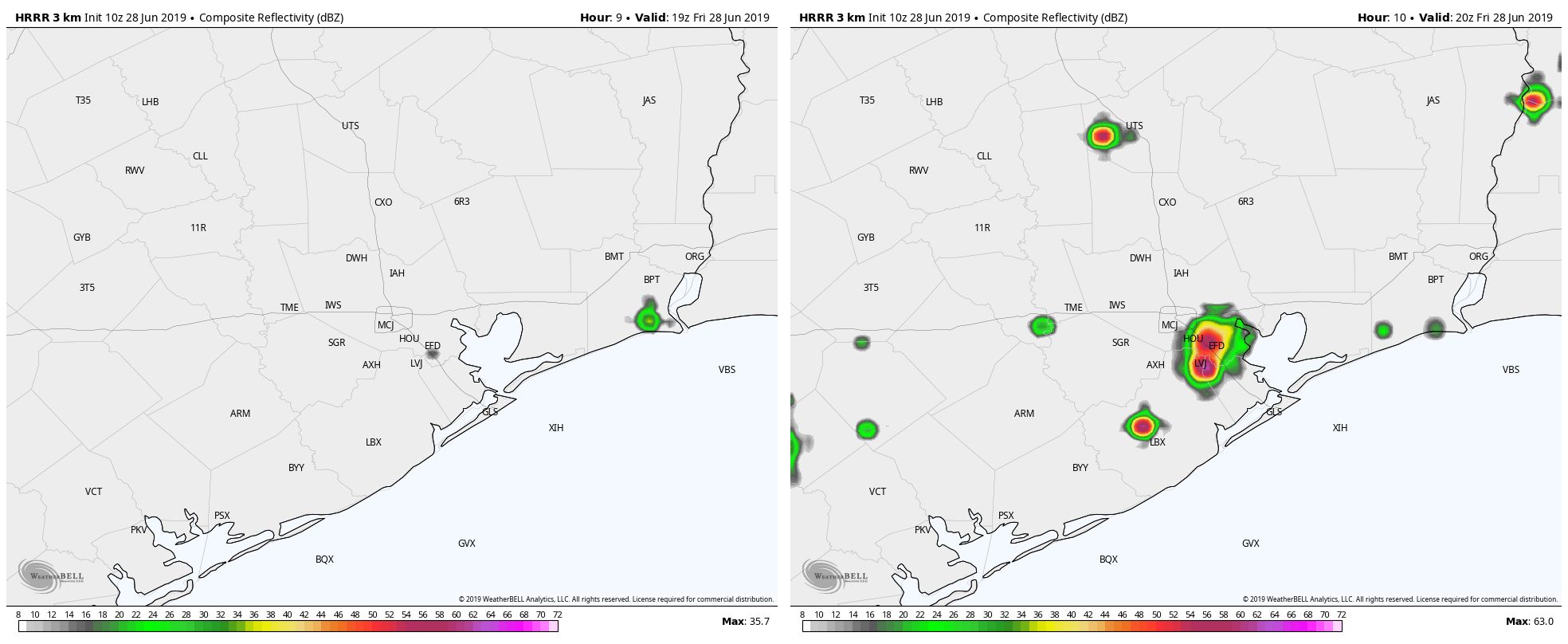
High resolution modeling suggests these storms will initiate around 2pm or 3pm and then wane by or before sunset with the loss of this daytime heating. Rainfall could be briefly heavy under some of these storms, potentially making something of a mess during the evening commute. However, we don’t have any flooding concerns beyond the usual mess on streets. Lows Friday night should fall into the mid-70s.

Saturday and Sunday
The weekend forecast looks more or less the same as Friday. High temperatures could come down a couple of degrees, to around 90 to 93 degrees, but we’re still looking at a pair of partly to mostly sunny days with the potential for showers or thunderstorms. The coast is probably slightly favored over inland areas in terms of rainfall, but in truth showers could pop up quickly pretty much everywhere on both Saturday and Sunday. Average rain accumulations will be less than 0.5 inch, probably, but that doesn’t mean much if one of the heavier storms pops up over your head. Bottom line: If you have outdoor plans, have a contingency to duck inside somewhere.
Monday
Probably a drier day, with only isolated showers, and highs in the low 90s.
Tuesday and Wednesday
A surge of moisture will push inland from the Gulf of Mexico, pushing rain chances on both days up above 50 percent. For now, almost all of the available guidance holds rain accumulations at 0.5 to 1.5 inches. We’ll have to watch this, however, due to the potential for heavier showers with the available atmospheric moisture. Highs will be in the upper 80s to low 90s.
July 4th
Our early look at the holiday suggests conditions will turn drier on the July 4th holiday, and our preliminary outlook for fireworks is good. More on this Monday.
So long as it isn’t flooding, we should be welcoming any rain we can. I’d like to make it a summer without a burn ban (i.e. super dry).
So our Galveston camping this next week will be a wash out
As a Galvestonian, most of the time when there is some rain event in Houston it doesn’t make it to us. I would check our local weather with WunderUnderground because we have a few people with good set ups so you can get an accurate~ report from the island =)
Yeah, you just take the brunt of any hurricane for us, for which we are thankful.
Darn. I was hoping I could have a peaceful night without fireworks and poor terrified dogs. Looks like it’ll be migraine city for me after all 🙁
Not to mention those of us who want to be asleep before midnight.
As long as the rain is GRADUAL, as long as it further delays the “wonderful” UGHUST weather, I’m for it. And a full week without the sprinkler system, an added benefit!
We were surprised to drive through hail at IAH yesterday about 5:30 pm.
Was wondering if there is an update for this weekend and for the week.
Thanks