Houston saw more scattered rather than widespread showers on Monday, and that pattern should more or less hold for most of this week as Houston lies beyond the edge of a high pressure system. This will allow for some areas to see downpours today, and others just sunshine, nearby clouds, and humidity.
Tuesday
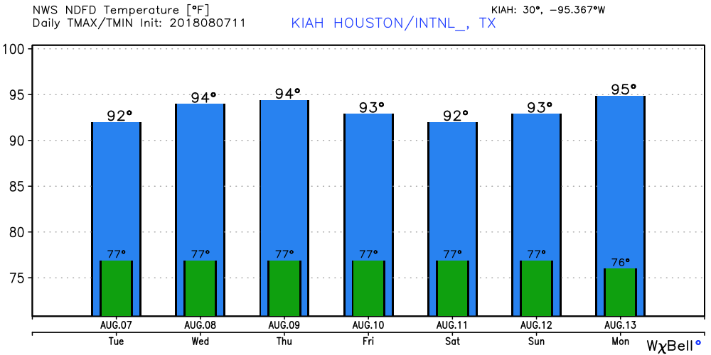
Houston will see partly sunny skies today, with highs in the lower 90s. We can expect showers to develop offshore and move inland throughout the day, although again, coverage should be more scattered rather than widespread. Where storms set up, people may see up to about one-half inch of rain fairly quickly, but the storms should move off pretty quickly.
Wednesday and Thursday
Conditions for rainfall become slightly less favorable during the middle of the week, as we may see some capping of the atmosphere. I’d peg rain chances at 20 to 30 percent both of these days, with mostly sunny skies and high temperatures in the low- to mid-90s.
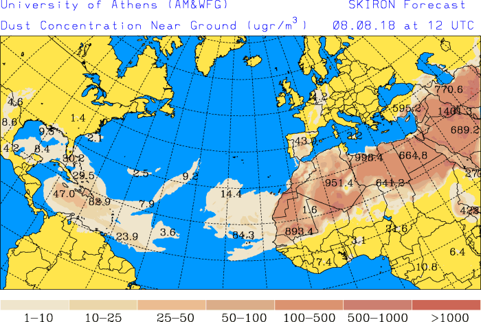
We continue to get a lot of questions about African dust. Some of the latest computer models suggest the dust will remain mostly at bay from the central and upper Texas coasts this week—although the dust will remain in place over the Gulf of Mexico—so that shouldn’t be something we have to worry about too much in terms of allergies.

Friday, Saturday, and Sunday
I wrote yesterday that I’d hoped we find some answers on weather conditions for this weekend, but I’m afraid there remains a fair bit of uncertainty. The forecast models just don’t really agree, at all, about how far a cold front will penetrate into northern Texas, and this leads to uncertainty in the downstream effects for greater Houston. The best bet, for now, is probably partly sunny days, with highs in the low 90s, and a healthy chance (~50 percent) of showers during the day time. Again, we’ll try to refine the forecast as we get closer to the weekend.
Next week
Right now I don’t see any signs of high pressure building over Houston early next week, so we’ll go with a persistence forecast of highs in the low- to mid-90s with a modest chance of afternoon showers. It’s safe to say confidence is fairly low.
Yesterday evening the weather.com app had an 80% chance of rain for today in my area (NW Houston) and I was elated! This morning I checked again and the rain chance had dipped to 20%, what happened?
We only got about 2/10ths” yesterday and could really use some rain!!
Thank you guys as always!
That SAL can stay as long as it wants if its preventing atlantic hurricane activity
Preach.
So is partly sunny the same as mostly cloudy?
Most of the time that is partly true.
Buh. We’re at the part of the year where I see a couple of 92 degree days in the forecast and think, “oh good, some cooler weather!”
“It’s safe to say confidence is fairly low” = “High confidence in low confidence”?
For the past few years I’ve noticed a “cap” over the middle of the city which prevents showers and storms from forming under the it while all around it are storms and heavy rain. Under the cap there is blue sky, sunshine and some wispy clouds. It’s frustrating! Why does this happen? Pollution, high temperatures made hotter by green house emissions, lack of an ozone layer?
Eric Berger, thanks so much for the post.Really thank you! Great.