This post summarizes the historically wet period from the spring of 2015 through the summer of 2016 for the greater Houston area. Not only did the region set a record for total rainfall, it also experienced an astounding six significant rainfall events in just a little more than 12 months. Read on for a full analysis.
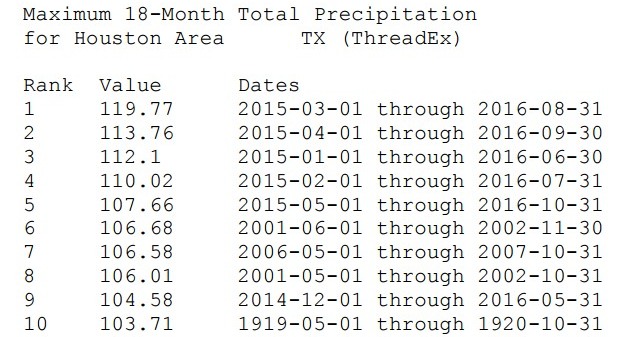
Based upon data from the National Weather Service, the 18-month period from March 1, 2015, through August 31, 2016, ranks as the wettest 18-month period on record for the city of Houston. In fact, the table below shows that each of the top-five wettest 18 month periods in Houston came during the last two years. Prior to 2015, Houston’s wettest consecutive 18 months had yielded a total of 106.68 inches. The March 1, 2015, through August 31, 2016 period annihilated that record by more than a foot of rain, with a total of 119.77 inches.
Here’s the data:
Now let’s take a deeper look at the six historic rainfall events that occurred between May, 2015 and May, 2016, and which helped produce this record. All of the data for these storms, and the summaries of each one, come directly from reports produced by the Harris County Flood Control District’s Jeff Lindner, who does an excellent job of monitoring the meteorology of major storms affecting the Houston region.
May 11-13th floods (2015)
These rains were most pronounced over the Clear Creek watershed.
“A slow moving storm system over the southwest US combined with copious moisture from both the Gulf of Mexico and Pacific Ocean to produce several rounds of excessive rainfall across southeast Texas from the morning of the 11th to the afternoon of the 13th,” according to Lindner.
- Rainfall averaged 6.0-8.0 inches from Friendswood to Deer Park and 8.0-10.0 inches in a small area from I-45 to NASA along NASA Rd 1 and Bay Area Blvd.
- A NASA employee in the Bay Knoll subdivision recorded 11.98 inches of rainfall in 3-hrs between 11:00 p.m. and 2:00 a.m. with a home weather station.
- A CoCoRaHS station recorded 10.52 inches in the same general area and another CoCoRaHS station recorded 8.92 inches a few miles from NASA. It should be noted that the 11.98 inches of rainfall in 3-hrs is 2.6 inches above the 500-yr rainfall frequency.
- A comparison of the 11.98 inch 3-hr rainfall total against Tropical Storm Allison in the same area yielded a rainfall rate 3.0 inches greater than Tropical Storm Allison. The Tropical Storm Allison 3-hr rainfall rate in this area was 9.0 inches.
Memorial Day Floods (2015)
This was the event that both scarred the southwest area of Houston, in terms of flooding, and caused the Houston Rockets to keep Toyota Center open after a basketball game so fans wouldn’t have to immediately travel through the deluge.
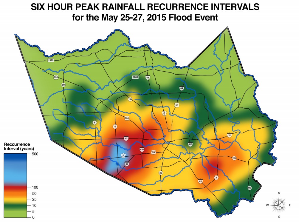
“After weeks of intermittent rainfall across Harris County, a slow moving line of thunderstorms moved into Harris County from central Texas during the evening hours of the 25th. Very heavy rainfall began around 8:30 p.m. across the northern portions of Harris County, while additional thunderstorms developed over central Fort Bend County and moved into Harris County from the southwest. A period of thunderstorm cell training occurred from 10:00 p.m. to 1:00 a.m. from Fort Bend County into north-central Harris County where the cells merged with the line of storms moving southward from northern Harris County. Thunderstorm cell mergers continued over central and southwest Harris County for several hours resulting in widespread significant flooding. A Flash Flood Emergency was issued for Harris County at 10:52 p.m. on the 25th for the first time ever,” Lindner wrote.
- Total rainfall amounts averaged 3.0-4.0 inches across much of Harris County with totals of 4.0-6.0 inches from Humble to Jersey Village to Katy, and eastward to Galveston Bay.
- Rainfall totals of 8.0-10.0 inches were recorded on the northwest side of the City of Houston southwest to Sugar Land. A maximum rainfall accumulation of 11.0 inches was recorded at Brays Bayou and Beltway 8.
- A CoCoRaHS observer 6.2 miles west of Downtown Houston recorded 10.03 inches of rainfall. Another observer 3.4 miles northeast of Richmond in Fort Bend County recorded 11.88 inches of rainfall.
- An average rainfall of 5.3 inches occurred across Harris County in a 12-hr period which equates to 162 billion gallons of water.
- Rainfall on Brays, lower White Oak, Keegans, and Buffalo Bayous ranged between the 50% (2-yr) frequency to well in excess of the 1% (100-yr) frequency for the time periods of 15-min to 12-hrs.
- The highest rainfall amounts occurred in the Buffalo and Brays Bayou watersheds for the 2-6 hr time periods and are between the 1% (100-year) and 0.2% (500-year) frequency.
- The total flooded houses in Harris County may have been in excess of 6,335.
Oct. 24-25 rainfall (2015)
I’ll always remember this event, because it began the day after I created Space City Weather. In fact, the threat of these storms provided the impetus for starting the site immediately, rather than waiting for a few days to catch my breath after leaving the Houston Chronicle.
“A strong upper level storm system combined the remains of eastern Pacific Hurricane Patricia and a developing surface low off the middle and upper Texas coast to produce a moderate to heavy rainfall event from midday on the 24th to mid morning hours on the 25th. Record moisture levels were observed on the Brownsville sounding on the evening of the 24th for late October,” Lindner wrote.
- The majority of the rainfall fell in the 24-hr period from noon on the 24th to noon on the 25th. Widespread and consistent rainfall occurred from 9:00 p.m. on the 24th to 4:00 a.m. on the 25th especially over the central part of Harris County including Downtown Houston.
- Total rainfall amounts averaged 6.0-8.0 inches across a large part of central Harris County. Rainfall amounts averaged 4.0-5.0 inches over the northwest part of Harris County and 5.0-6.0 inches over the southeast part of Harris County.
- An area of 9.0-10.0 inches was recorded from Sheldon to Crosby in eastern Harris County.
- Rainfall for the 12-hr to 24-hr time periods averaged between a 50% (2-yr) and 10% (10-yr) for all watersheds. Portions of Buffalo Bayou, White Oak Bayou, Cedar Bayou, and Jackson Bayou recorded rainfall at or above the 4% (25-yr) frequency.
- Memorial Day 2015 Rainfall vs October 24-25th Rainfall: While overall total rainfall for the 24-hr period were similar for both events, the rainfall intensity during a shorter duration for the Memorial Day event resulted in a large difference with respect to flooding from both bayous and creeks.
Halloween rains (2015)
Will it or won’t it rain on Halloween? It did, but fortunately the really heavy rain came before the trick-or-treating hour.
“A strong upper level storm system combined with high moisture levels to produce a band of excessive rainfall and flooding across Harris County on Halloween. Thunderstorms rapidly developed shortly after midnight on the 31st over Matagorda and Fort Bend Counties and moved into Harris County around 1:00 a.m. The thunderstorms trained or moved over the same areas between 1:00 a.m. and 4:00 a.m. with significant rainfall occurring over the southwest and south-central portions of Harris County into the east-central part of the county. After a brief break between 5:00 a.m. and 8:00 a.m. an additional round of thunderstorms slowly moved across Harris County from west to east producing additional heavy rainfall and worsening ongoing flooding conditions,” Lindner writes.
- The heaviest rains fell in a 12-hr period from midnight to noon with the most intense rainfall occurring between 2:00 a.m. and 5:00 a.m. over southern and eastern Harris County.
- Total rainfall amounts averaged 5.0 to 7.0 inches from Sugar Land to Downtown Houston and 9.0 to 12.0 inches from the south side of Downtown Houston to Galena Park to Highlands to Crosby.
- Rainfall totals south of this band of maximum rainfall over southeast Harris County averaged 5.5 to 7.5 inches and rainfall northwest of this area over northwest Harris County west of Beltway 8 averaged less than 3.0 inches.
- A maximum 48-hr rainfall total of 13.12 inches was recorded at Cedar Bayou and HWY 90. An average rainfall of 5.2 inches occurred across Harris County in a 12-hr period which equates to 153 billion gallons of water.
- Rainfall across middle and lower Brays Bayou and Sims Bayou averaged between a 10% (10-yr) and 2% (50-yr) for the 1-hr to 12-hr rainfall amounts. Rainfall on the lower San Jacinto River below Lake Houston averaged between a 2% (50-yr) and 1% (100-yr) for the 1-hr to 24-hr rainfall amounts.
- Rainfall on Carpenters Bayou, middle Cedar Bayou, and Jackson Bayou/Gum Gully averaged between a 2% (50-yr) and 1% (100-yr) for the 1-hr to 24-hr rainfall amounts.
Tax Day Floods (2016)
Space City Weather has a special category devoted to this significant flooding event.
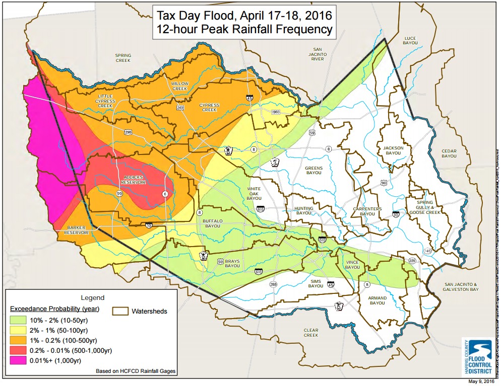
“A slow moving and powerful upper level storm system over the southwest US combined with near record moisture levels for mid-April produced a devastating flood event over the northern and western portions of Harris County from the evening hours of April 17th into the day of April 18th. Excessive rainfall spread across northwest Harris County during the late evening hours of the 17th into the early morning hours of the 18th. Significant cell training and slow movement of the thunderstorms resulted in a large portion of northwest Harris County receiving between 10-15 inches of rainfall during the morning hours of the 18th. Torrential rainfall slowly shifted into central and southwestern Harris County between 3:00 a.m. and 6:00 a.m. A Flash Flood Emergency was issued at 1:45 a.m. for northwest Harris County and was later expanded to include portions of western and north-central Harris County,” Lindner summarizes.
- The majority of the rainfall occurred in a 12- hr period and averaged 12.0-16.0 inches from Tomball to Addicks westward to Waller County.
- Short duration rainfall rates from less than 1-hr to 3-hr were extreme over this area including a 2-hr total of 7.3 inches in Addicks. Rainfall averaged 10.0-12.0 inches over the headwaters and upper portions of Greens and White Oak Bayous for the 6-hr and 12-hr time period.
- An average of 7.75 inches of rainfall occurred across Harris County equating to over 240 billion gallons of water, compared to an average of 5.3 inches and 162 billion gallons of water from the Memorial Day flood of 2015.
- Cypress Creek, Little Cypress Creek, Langham Creek and Horsepen Creek all experienced 500-year or greater flood events.
- The flooding resulted in seven fatalities in Harris County with an additional one in Waller County and one in Austin County all of which were vehicle related.
- Approximately 40,000 cars and trucks flooded with the majority at homes and apartments.
- Several public school districts in north and west Harris County were closed all week.
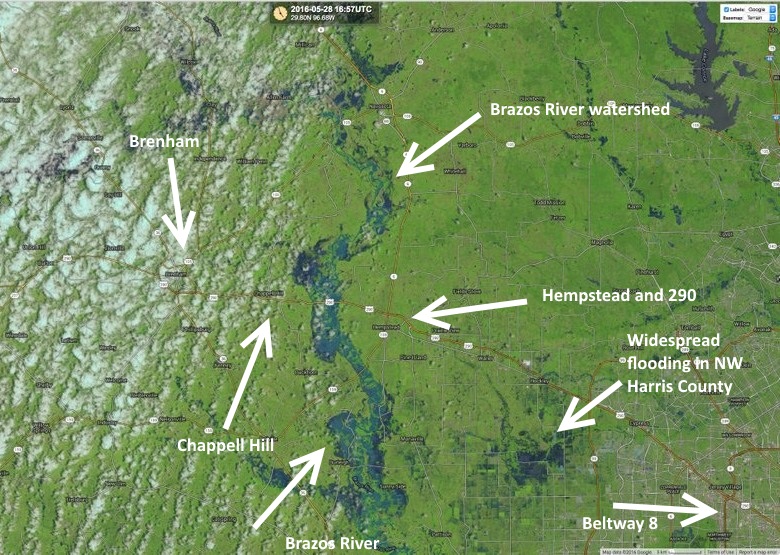
Brazos River flooding (2016)
We probably all remember these floods which pushed parts of the Brazos River to historic flooding levels.
“Only six weeks after the April 2016 “Tax Day” flooding another significant rainfall event occurred over the north and northwestern parts of Harris County into Waller, Montgomery, and Washington Counties. A strong upper level trough combined with above average moisture levels and favorable upper level wind patterns leading to a round of slow moving excessive rainfall producing thunderstorms during the afternoon hours of the 26th into the overnight and early morning hours of the 27th. Portions of Washington County recorded over 12 inches of rainfall in a 3-hr period. This line of storms expanded and drifted in north Waller, southern Montgomery, and extreme northern Harris counties during the early evening hours producing extensive amounts of rainfall and rapid flash flooding. This line of storms trained west to east for much of the overnight hours before gradually weakening by sunrise on the 27th. During the afternoon of the 27th a secondary line of thunderstorms producing excessive rainfall moved into Harris County from the north,” Lindner writes.
- A Flash Flood Emergency was issued at 2:25 a.m. on May 27th for extreme northern and northwest Harris County northwest into Waller, Montgomery, Grimes, Austin, and Washington Counties.
- This is the second issuance of a Flash Flood Emergency for a part of Harris County in a six week period and the third time in the period of one year.
- A total of 11.79 inches of rainfall was recorded at the Brenham weather station in a 6-hr period during the afternoon of the 26th which is very close to the 500-yr rainfall mark.
- A total of 16.33 inches fell there in 12-hrs which exceeds the 500-yr for that time period by 1.63 inches.
- Widespread 3-hr rainfall totals of 5.5-7.0 inches were recorded over southern and western Montgomery County, including 7.2 inches on Lake Creek at Egypt, and 6.3 inches on Bear Branch at FM 2978 in The Woodlands.
- The locations with the most rainfall during the May 26-27th event were also impacted during the 2016 Tax Day flood event. In fact, the corridor of maximum rainfall during the May 2016 event was only a few tens of miles north of the corridor of maximum rainfall during the April 2016 event.
- Lake Conroe rose to a peak elevation of 204.51 ft on May 28th, the 3rd highest pool elevation recorded since the creation of the lake. Higher pool elevations were recorded in October of 1994 (205.88 ft) and in May of 1983 (204.66 ft).
Summary
Houston had its wettest 18th months from the spring of 2015 through the summer of 2016. There were no tropical storms that forced these rain events, just an extremely moist atmosphere and a series of very potent upper-level storm systems. The ultimate cause of this flooding isn’t entirely clear, but it’s safe to say that rapid development of rural areas— converting prairies into concrete—and a warmer climate, likely played some role in exacerbating what were already heavy rains. It has now been nearly five months since the last extreme rainfall event so perhaps we have exited this historically wet pattern.
Posted at 2:30pm CT on Monday by Eric
May 11-13th floods (2015)
I can attest to this. I had about 10 inches between 9:30 PM and midnight when it finally let up. This is approximate because I had to go out and dump the garden rain gauge about every hour. About a dozen homes in the older part of my subdivision near Ellington flooded because of plugged up sewers. When it was over ,the trash line in the drainage ditch about a third of a mile from ny house was roughly 6″ from overflow. I’ve lived here 26 years and have never seen (or heard, in the case of rain hitting the roof hard) anything like it before and I hope will never again.
Do you expect any seriously heavy accumulations of rain or high gusty winds & lightning Wed-Fri, Eric?
Nope.
Is this (at least part of) the reason we’ve had such high overnight low temperatures ? Consistent upper 70s/low 80s is not something I recall being the norm in summer months.
Yes, the additional cloud cover has aided in keeping nights warmer and (for a time) it helped to moderate daytime temperatures earlier this summer.