As of 7:30am CT on Saturday, Hurricane Irma continues to move westward, with its center just inland over the northern coast of Cuba. This more westward track, taking the storm over Cuba, is a scenario I discussed a couple of days ago—the Cuban—which would spare the Miami area the worst effects of Irma.
The track over Cuba has weakened the storm’s maximum winds to 130mph, and additional weakening is possible before Irma moves back into the Straits of Florida later today or tonight. Here’s a quick look at the official forecast track:
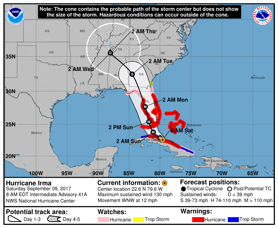
Here are the implications of this changing track:
Cuba: The island nation is being battered by the storm
Florida Keys: Still in line for a major hurricane today and Sunday. Expect devastating winds, rainfall and storm surge.
Miami area: As Irma continues to move westward, its center will bypass the Miami metro area, sparing the heavily populated southeastern coast of Florida from the worst effects of winds and storm surge. Hurricane force wind gusts are still likely, but they will probably not cause widespread damage. Inland rainfall amounts of 15 to 20 inches are possible, and flooding is a significant concern.

West Florida from Panama City to Naples: These areas are now in line for direct effects from Hurricane Irma. Here’s a look at the early Saturday morning operational run of the European model showing the most likely track for the storm. This image shows the model’s forecast position of Irma on Sunday night, at 7pm CT.
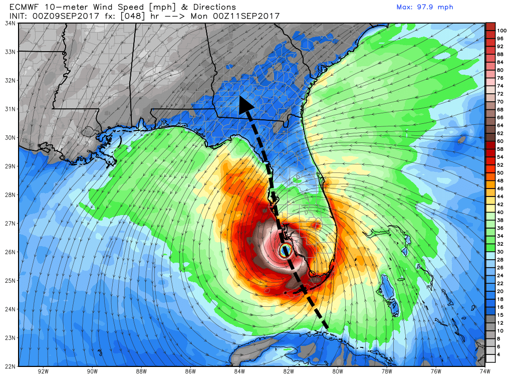
Along this track—which at this time is most likely, but not locked into stone—areas from Tampa to Naples would be battered by hurricane force winds and significant storm surge.
I have a lot of questions about Irma from this point forward which will adjust expectations from this storm accordingly. How much more will it weaken over Cuba today? (It has already decreased from 160mph to 130mph). How soon will it restrengthen once it moves off Cuba into the waters between the island and southern Florida? How far west will its track go, i.e. how long will it remain over water before finally coming ashore in Florida? The longer its center remains over water, the more time it will have to restrengthen.
The entire state of Florida should be bracing for high winds and heavy rainfall this weekend, but as the track of Irma continues to change, the bullseye for potentially catastrophic winds, surge, and rainfall will as well.
I know everyone is focused on Irma, but I have to ask about Jose which is now a Cat 4.
Is Jose going to track right behind Irma / same path?
No. Check out the National Hurricane Center forecast for Jose:
http://www.nhc.noaa.gov/graphics_at2.shtml?cone#contents
Everyone is freaking out in atl im more concerned about the storms moving west vs north I’ve seen it happen during Katrina no storm is prodictable no storm I would not be shocked if it moved just west of Florida into the gulf and either goes north or continues west atl should not be worried I wouldn’t exspect on current models that it would get any hurricain strength winds till tues night going into wens when issaic hit New Orleans it sat on us for 3 days anything is possible I’m not buying the tracking just yet it’s too early by Tomm we should know for sure where this storm is coming and I would not rule out the gulf coast the storm is simply running out of time too turn north
Is there any chance it will continue moving westward and not land on Florida?
I wait twice a day for your posts with bated breath. I live in the Houston area and hate to see others hit with a hurricane. Thanks for the regular and sane updates.
I agree with Yvonne . Your calm, accurate daily updates are easily understood and have become the only weather news I will follow. Space City Weather is a blessing to many !
I’d like to add my compliments to the ones I’m reading here, and my sincerest gratitude, for your clarity, for your lack of hysteria, for your literate and comprehensive reporting during this terrifying hurricane season. I have stopped bothering with any other weather news source.
I BEILEVE this is what is going to REALKY happen weather channel is reporting Irma is running out of time to make a north Turn gulf coast shoukd he on high alert as for Atlanta I would be worried bit even if the course stays the same I do not BEILEVE that storm will make it to atl by Monday possibly tues
I think you’re misinterpreting what the weather channel said. They didn’t say it’s running out of time to turn. They said we’re waiting on the turn that will ultimately determine the track. The title of the cast was “Time running out Irma nearing Florida.” Don’t be a fear inducer
Thanks for the early morning update, Eric. FL is 24 hrs or less from initial landfall so we are watching closely in Texas and keeping our eyes peeled for those in this monster’s path.
If possible please provide us all with an afternoon or evening update. The world is watching and we all appreciate your absolute hard work and dedication.
Well, I’m not Eric, but here’s what NHC says:
“The eye has been moving toward the west or 280 degrees at about 8
kt. The hurricane is about the reach the southwestern portion of
the subtropical high, and the expected turn to the northwest and
north-northwest should begin soon. The track guidance is tightly
packed and takes the hurricane over the Florida Keys and near or
over the Florida Peninsula. The NHC forecast is in the middle of
the guidance envelope and given the good agreement among models, the
confidence in the track forecast is high.”
Family lives on Sanibel and evacuated to just south of Valdosta GA…which direction should they head for least chance of impact Monday? We are concerned their present location is not much better than where they started from!
If they’re close to the coast, move inland, at least 10 miles from the coast if possible.
If they are in a windstorm threat area, find a strong building (NOT a mobile home) and hunker down there. Take as much of their stuff as possible…blankets, go bag, all that.
Once they’re inland, the threats are wind and rain. Most people who die in hurricanes die in water. As long as they stay away from flood and surge areas, they’re more likely to “only” have a nightmarishly terrifying night.
Thanks Eric. If she does this some of my family will fare better than thought before. That said others will have it worse. Really no good scenio for the state. Sparing Miami is good but others get the hit like Tampa. How bad will the dirty side be?
Tampa may not get the dirty side, it may very well get the brunt of the storm.
One more question – San A Bel Island. Any idea how it might fare? House there, family in Tampa, Orlando and Melbourne.
Yesterday and before you had 20-30% option for Irma to move west into Gulf if she drifted over Cuba… How likely is that option now vs a WEST coast run off the coast…which would have massive storm surge/wind damage from Naples to north of Tampa…
Is the rain from Jose tempting Irma back to,the coast vs his force pushing her more west into Gulf? How is the pressure over Keys likely to draw her TO west coast landing?
Thanks for your tempered approach
Family in Sarasota area who are sheltering in place–so skin in the game makes me scared, scared, scared…
Here is an interesting graphic from WaPo (should be free for everyone):
https://www.washingtonpost.com/graphics/2017/national/how-big-is-hurricane-irma/?hpid=hp_hp-top-table-main_irmagraphic-6pm%3Ahomepage%2Fstory&utm_term=.8019b5657fbb
The hurricanes are being measured in terajoules, which take into account both wind speed and size to tally up the destructive force. Andrew, which wreaked so much havoc on FL, was “only” 15 terajoules. Harvey was 28, Katrina 116, Irma 112, and Sandy 330! For more perspective, Sandy was a cat1.
There’s been talk of replacing the Safir-Simpson scale since at least after Ike (Ike punching above its cat2 status because of its size and all that storm surge) but it doesn’t look like it has caught on yet in most of the weather reporting. Maybe after Eric and Matt come back from a very well deserved vacation, we could have a discussion about what’s the best way to rate the destructive potential of storms.
How far inland will the storm surge reach, assuming a hit to Venice/Sarasota area at high tide, as is currently predicted. Are we still looking at an 8′ storm surge?
Seems as though this turn is getting less and less likely despite all models it continues to plow west. If it doesn’t turn, then Mexico is ill prepared for a monster storm
Good morning – I notice that the Official Track Forecast from the NHC ends in a large circle (2 am Wed and Thursday). I remember seeing the same type of probability cone in the Houston area during Hurricane Harvey. Does this mean that Irma also has a possibility of stalling and dropping mass amounts of rainfall on the SE US similar to what happened with Harvey?
Thanks again
Is any even remote possibility that Irma will go west and will influence our weather?, it was I tiny move to the west every day…
I was stationed at Keesler AFB when Camille came ashore. Is Irma likely to follow that path?
So seaside in Florida may take a big hit? I know many Texans with homes there. Double whammy for them.
Eric, Thanks for the good work with this blog. As with regard to the current position of IRMA it does seem that the system is taking a track more westward than the ECMWF model runs a day or two ago. Is there a strong reason why this system will not continue defying analyses models and formally enter the GOM ?
I have family who live in southwest Georgia. Based on current models, what should they prepare for in terms of wind/flooding? I just went through Harvey (my first hurricane), and I’m fine, thankfully, but I am concerned for them.
Eric…what are your thoughts about those of us in the Florida Panhandle?/ We are near Ft. Walton Beach, Destin and Crestview.
If this storm continues westward is it possible that it will hit land here in Texas or affecting our weather at all? The news says not to worry, but after Harvey it is nearly impossible not to. If there is a possibility of it coming here I just want to be prepared. Thanks!
The storm hasn’t turned north yet, right? A weatherman just said that the troughs that they thought all along would turn the storm north turned out not as strong as they thought. So I guess they’re waiting for those troughs to kick in, and that we’ll get hourly updates from the NWS. Is everyone else seeing the same thing?
This information is very useful.