Just wanted to provide an update on conditions for Tuesday, especially because it now appears as though any freezing precipitation may move into the city a little earlier than expected. I know there are a lot of people and organizations out there looking to make decisions, so as of about 12:30pm CT on Monday, here’s what we know: A cold front is still on track to move through Houston between midnight and sunrise on Tuesday. The key questions are how cold it will get, how soon, and the timing of the precipitation. Here’s a look at what may happen at certain times.
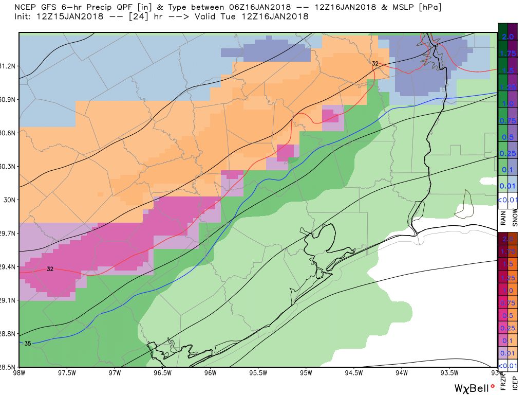
Midnight-6am Tuesday
In the map below we see a mix of sleet and freezing rainfall moving from the northwest into the Houston metro area. This forecast from the GFS model shows accumulations for the 6-hour period from midnight to 6am, and they are slight. However when it comes to freezing rain (shown in pink) it doesn’t take much to cause problems on roadways, especially bridges and roadways.

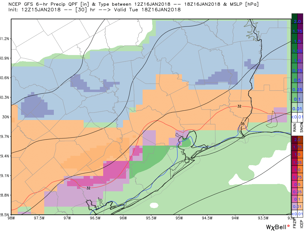
6am-noon Tuesday
This forecast map shows sleet (and some freezing rain) moving into Harris County by or before noon, suggesting there may be some concerns on area roadways during the morning hours. Please bear in mind these forecast maps are only approximations. Indeed, instead of sleet or just freezing rain, most areas are likely to see a “wintry mix.” The bottom line is, while there may be some problems on Houston roadways during the morning hours, it’s not possible to say whether these are going to be “oh look, a little sleet is falling”-type problems, or “610 is an ice-rink”-type problems. For now, I’d lean toward the former, with this being a minor nuisance event. But this is just an informed guess rather than confident prediction.
Noon-6pm Tuesday
Drier air will follow the front into Houston, and at some point during the afternoon or very early evening hours we can expect the precipitation to end. However before that happens the freezing line will continue to progress toward the coast, likely reaching it during the afternoon hours. Here’s the forecast map for accumulations from noon to 6pm on Tuesday.
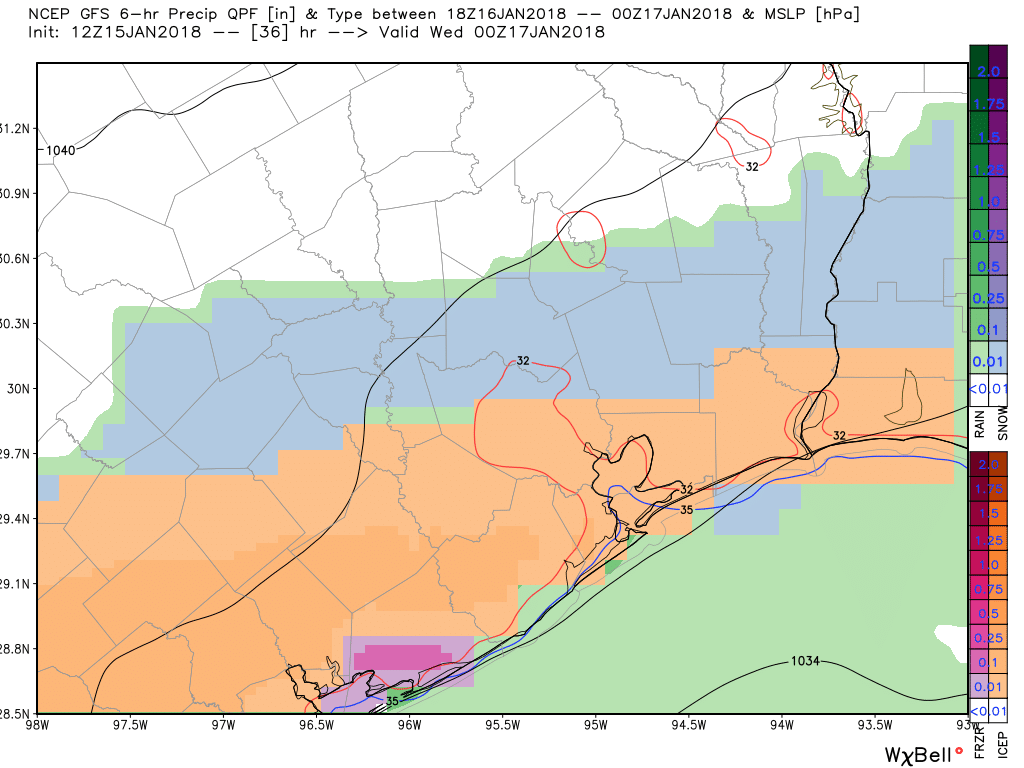
The good news is that, as mentioned, the precipitation is going to end Tuesday afternoon or evening. The bad news is that, after the precipitation ends Tuesday, we could see some clearing skies from north to south early on Wednesday, which could allow temperatures to really bottom out at around 20 degrees for inland areas, with mid-20s in the city of Houston.
While Wednesday will certainly be cold, roadways should be fine.
Is this projected to be a hard freeze situation? I was wondering if shrouding outdoor plants again would be prudent before Wednesday.
Yes, this will be a hard freeze like we experienced just after New Year’s.
Thanks for the heads-up
What will driving conditions Tuesday night probably be like in the middle of town?
Not wanting to say the S word I see.. Thanks for not jinxing it!
Once again you do a fantastic job for Houstonians. Thank you for your dedication to quality reporting. Your reports are greatly appreciated.
Eric – You are ruining my “out of school” vibe.
Many might ire on the side of caution depending on the forecast tonight and close for tomorrow. Area schools are in a Catch-22 situation.
I imagine Turner and Emmett will close down the whole city and county for at least a week and advise people not to drive anywhere north of a line from Brownsville to Tampa, FL.
The Eyewitless News Teams will deploy their mobile units to catch an HD picture of the first frozen pellet to get within three feet of the ground.
Meaning I’ll have a pretty easy drive to and from work.
Any days missed for weather at this point will have to be made up.
…and as I type, the phone rings, and Pearland ISD is closed tomorrow…
don’t take my word for it… please check with your schools.
I’ve got a kiddo commuting from our house north of Tomball to the UH main campus tomorrow for the 1st day of classes. About 42 miles one way. Yikes.
UH is closed tomorrow.
What is the difference in “sleet” and “freezing rain”? I thought it was the same thing.
Freezing rain is liquid rain that freezes upon impact on the ground, your car, etc. Sleet is some sort of precipitation in the process or trying to turn into some sort of frozen precipitation, likely not snow but certainly not rain. I’d like to say sleet is the same as ice pellets, but I would suspect there’s a meteorological fine line I’m not aware of.
Paul Sventek, Is that you from Chicago’s St. Dan’s. I remember so clearly that you wanted to be a weatherman. Seems you are on top of things. We are trying to contact you for a 50th reunion but I have often wondered if I would see you on tv someplace as a weatherman? Send your contact info to me. If you can’t make the reunion, Please let me know what you are doing with yourself.
Sleet is frozen when it comes down. Freezing rain is liquid, then freezes when it lands.
See the link below
http://www.weather.gov/rnk/measure_icing
If you go to the Houston National Weather Service website, then click on “Winter Forecasting,” there’s a nice graphic showing the difference.
http://www.weather.gov/hgx/
Sleet falls as a frozen water, just not as soft as snow, more like little tiny ice pellets. This must mean that the water freezes before it gets to the ground.
Freezing rain falls as water and when it lands freezes because the temperature at the ground is below freezing.
I realize that now you might want to know the difference between how snow and sleet is made. I don’t know the answer to that.
Winter Storm Warning for us now.
Katy should stay put….pls, no I10 carambolage…
Thanks Eric! I guess CCISD has been reading your blog! My teen is thrilled no school tomorrow…her Dad and I, not so much so!! Sounds like a good day to telework.
Schools are cancelling, but the gist of your report is “it might be a problem?” I’m very confused. Can you elaborate?