Houston continued to set record high temperatures on Monday—a mark of 89 degrees at both Bush Intercontinental and Hobby airports broke records at each location by a degree. Fortunately, this abnormally warm weather for November will finally come to an end later today, or tonight.
Today
We’ll have one more day with temperatures in the upper-80s across the region before a cold front pushes into Houston. As of 6:45am CT, the front was draped across Central Texas, and slowly pushing to the southeast. Temperatures (and especially dewpoints, which denote drier air) are considerably cooler behind it.
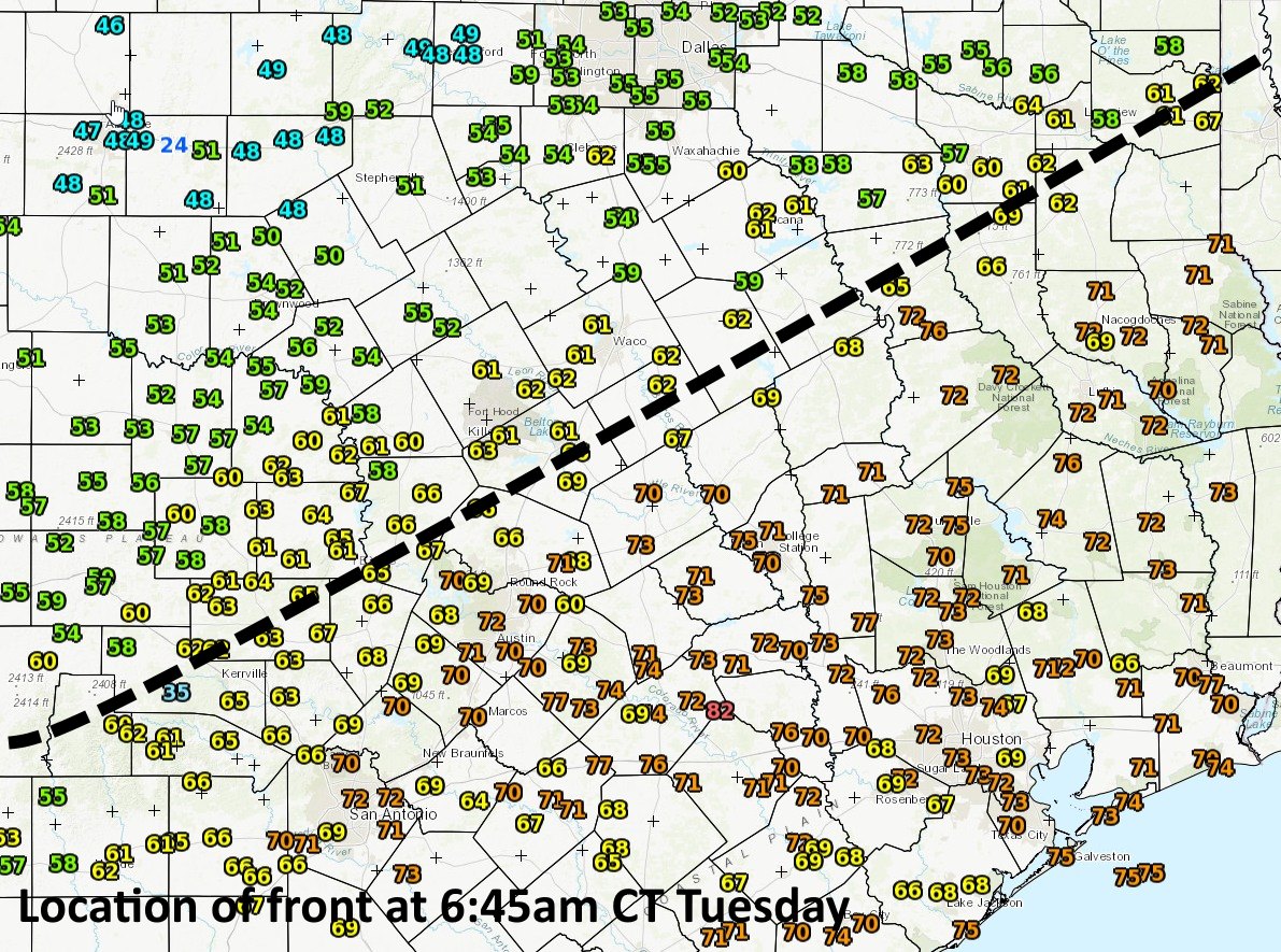
The front is moving a bit faster than expected, so it should arrive in the Houston area later this evening, and push off the coast by midnight, or shortly thereafter. Before then, we’ll be partly to mostly cloudy, and unseasonably warm. Afterwards, cold.

Wednesday
In the wake of the front, temperatures on Wednesday will remain quite cool, with highs likely only reaching into the low to mid-60s. Skies will remain mostly cloudy, and an atmospheric disturbance moving across the region could bring a decent chance of rain to the area, perhaps about a 50 percent chance of rain for inland areas, and 30 percent closer to the coast. I’m not expecting more than a few tenths of an inch of rain with this system. Lows Wednesday night should fall into the upper 40s for inland areas, and lower 50s closer to the coast.
Thursday and Friday
A couple of great days, with highs in the upper 60s to 70 degrees, partly to mostly sunny skies, and cool, but not cold nights generally in the 50s.
Saturday and Sunday
The weekend looks pretty nice as well. We’ll have a mix of partly sunny and cloudy skies, with highs generally in the 70s, and lows warming a bit into the low 60s. We can’t rule out a bit of rain later on Saturday or Sunday, but right now chances look pretty low, and accumulations slight. Highs likely remain the 70s for most of next week.
Fundraiser
Thank you to everyone who donated to our annual site fundraiser on Monday. We have had a tremendous response so far. This campaign will continue for another three weeks.
Thank you guys for running the best weather site in the world – Houston appreciates you !!!
Holy Cow…Eric…today’s forecast in the Houston Chronicle shows next Monday’s high to be 91…really…or “hype”?
No chance.
I have a half marathon on the 19th, keeping. Y fingers crossed for some cold weather like we had two weekends ago. Keep up the amazing job you two!
“The front is moving a bit faster than expected, so it should arrive in the Houston area later this evening, and push off the coast by midnight, or shortly thereafter. ”
See this is the kind of information that I used to look for in vain from the networks forecasts.
Thanks guys!
What are the low misty not really cloud covers racing from south to north in the wee hours of the night/early morning? I cannot tell if it is a weather phenomena or a release of something manmade? Have seen twice now. Last night and a couple nights ago. Each time, I wondered if we would wake to a raging cold front, even though the forming and unforming blankets and pockets seemed to be heading from the coast towards inland. It is a beautiful thing to stand and watch. Just mystifying (mist-ifying?).
Am smack in central Houston, too. Not near the coast where this looks like it might be at home.
Any thoughts or explanations? Thanks!
You know it’s humid when all the papers on your office desk feel moist. This weather is ridiculous!
Does Katy need to be evacuated ??
There’s not enough time. Shelter in place!
It’s a nit but “strong cold front” is bordering on hype-y. I was expecting high winds and temps into the 40s with that sort of headline.
It’s going to knock 25 to 30 degrees off of high temperatures today.