Good afternoon. Just a short-ish update this afternoon because, you know, meteorologists want to watch the Texans playoff game as well. Not a whole lot has changed from the forecast we published this morning. So for this post we’re going to summarize the forecast and impacts, and attempt to answer some questions readers have. Be forewarned: We don’t have absolute answers.
Forecast
An Arctic front will push into Houston overnight, likely moving through the downtown area before sunrise, and reaching the coast by sunrise or a little bit afterward. This will not be a ‘blue norther’ front in that while the winds will shift to come from the north, they are not likely to be howling. Temperatures will remain above freezing on Sunday, and should remain at or above freezing for the majority of the metro area Sunday night with the usual exceptions, places like Montgomery and Conroe.
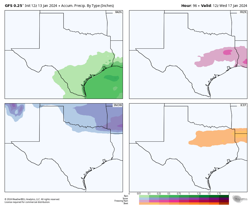
Monday is going to be a cold day. Most of the region will be in the 30s, with mostly cloudy skies. A passing disturbance will bring light, scattered rain showers into the area beginning late Sunday night or early Monday morning. Most of our model guidance still indicates this precipitation will fall as rain in Houston, with a transition to freezing rain northwest of the metro area, perhaps roughly along Highway 105. Bottom line: It’s going to be miserable outside in Houston on Monday, but you should be able to get out and about. We’re continuing to watch the freezing line closely, of course.
A secondary push of cold, Arctic air will arrive on Monday and that will nudge nighttime temperatures lower on Monday night. But there’s still a pretty broad range of uncertainty on how far the mercury drops on Monday night, depending on cloud cover and other factors. Our advice: prepare for a hard freeze in Houston, but don’t be surprised if temperatures are a little warmer. Tuesday night into Wednesday morning continues to look like the coldest night of the forecast period, when much of the metro area will drop into the upper teens to mid-20s. I don’t feel confident putting a finer point on those temperatures yet. We emerge from the icebox on Wednesday.
Now, let’s try to tackle some questions.
Is the power going to go out?
We’re weather forecasters, not power prognosticators, and so we have limited insight. Statewide temperatures do look 5 to 10 degrees warmer than the exceptional cold that led to widespread power outages in February 2021, and the state has invested in “winterizing” the grid in the three years since that disaster. All of that makes us feel pretty good about the state avoiding prolonged outages.
So far state officials have not called for conservation next week. But it seems like that may be possible, especially on Monday and Tuesday mornings, when the demand forecast from ERCOT is near to the expected supply. In any case, we’ll all see what happens together.
Are there going to be Airport delays?
If we get freezing rain at Bush Intercontinental Airport (or Hobby, for that matter) then yes, there could be some significant flight delays on Monday. But that does not seem likely at this time. For the most part this is going to be the story of cold weather rather than a winter storm. The optimist in me thinks that while there may be some airport delays on Monday and Tuesday, they probably will be due to the destination airports rather than conditions at Houston terminals. The pessimist in me is saying, “Uhh, dude, you’re out of your depth here.” Which is true.
Is school going to be canceled?
Monday is a holiday, to mark Martin Luther King Jr. Day. If our forecast is wrong, and we get more rain than expected on Monday, and conditions are a little colder, than we could see some icy bridges and overpasses on Monday night into Tuesday morning in Houston. That would be a reason to cancel schools in the Houston metro area on Tuesday. But right now we don’t anticipate that happening.
We should have even more confidence in the forecast by tomorrow. Tuesday and Wednesday mornings are going to be blustery and cold, with wind chills in the 20s or teens. Is concern about exposure getting to and from school a reason to cancel it? That’s not my call. But at present our expectation is that roads will remain passable during this winter event.
Should I drive to Dallas or Austin on Monday?
These are going to be difficult calls. Right now there’s a chance of light, freezing rain on Interstate 10 and Highway 290 on Sunday night and Monday. Will there be enough to stick on highways? Maybe a few bridges and overpasses. But I don’t feel great about making that call on driving to Austin right now.
As for Dallas, or places like Shreveport, I’m a little more confident that we’re going to see some decent freezing rain or sleet accumulations that could make travel hazardous. So if you’re heading north of The Woodlands on I-45, or north of Cleveland on Highway 59 on Sunday afternoon or Monday, I’d definitely check road conditions before leaving.
Is it going to snow?
Yes. But not in Houston. For any appreciable totals, you’re probably going to have to travel to Oklahoma or Arkansas on Sunday or Monday. Which, as noted above, is not advisable.


Updated info on your next update on the drive west would appreciated for us road trippers in town for the race. 😬
Yeah, there is still a 4F difference in the GFS and Euro models for Wednesday morning, with the GFS being warmer. I guess that’s about all you should expect this far out.
Should we be concerned about water main breaks and/or boil water notices?
It’s always possible with an event like this, but I think the probability overall is fairly low.
Thank you for your additional commentary and updating of the weather news. I read it all, even if I’ve heard it before. I’m retired and getting out is optional for me, but Saturday night and Sunday I do have some special events I’ve been planning on. Sounds like I’ll be able to make them just fine. Bless you and Matt.
Yes, you should be fine. Enjoy!
Dang. Hoping to WFH Monday and Tuesday.
Thank you for you honest, no hype forecasts!!
Should Katy evacuate?
IYKYK
Could you please get a little more specific about low temperatures on Galveston Island? You have lots of followers down here. I wore my SpaceCity weather heavy hoodie today. Thank you
MaryAnn
It may or may not freeze on Monday night in Galveston. It probably will freeze on Tuesday night, although at this point I’m not sure it will be a hard freeze.
Add me to the chorus of thankful readers for the no-hype update. As the headline says: it will be cold but manageable.
That means use some common sense: put on clothes when going outside, have a decent amount of meals prepared and food stocked, and be able to amuse yourself inside for a few days if needed.
Heck, this applies even when there’s not an Arctic blast approaching.
Whoa, it was clear and sunny and all of a sudden a thick shelf of clouds came in from the west..is that associated with the front?
Thank you for the updates and I hope you thoroughly enjoyed the beat down that the Texans put on the Browns.
That was quite a game!
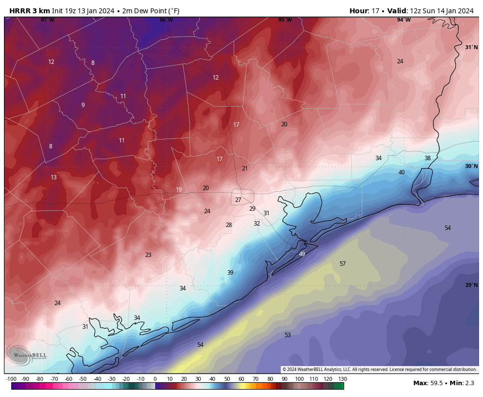
Thanks for all the updates, much appreciated. But wtf is a dew point? I don’t know what to make of that dew point map.
I believe from watching the TV guys that’s the number that would determine how low the temperature could reach. It’s something like humidity
It has to do with the amount of moisture in the air, the higher it is, the more humid it feels. Since it is going to be low based on the map you see, then the air will be comfortable and less moisture
What do you think it will be like driving to San Antonio at 8am on Wednesday?
Appreciate when you include 105 area. We are E of Cleveland and so that helps when you can guide those of us further north than where you are located.
I have to head to the airport- IAH from Cypress area around 6:30 am Monday morning for a flight that leaves at 10:00 am. Wondering if getting in from 290 is going to be possible?
Y’all are much better are communication forecast uncertainty than the National Weather Service. Last night at 11PM the NWS forecast for my area was a high of 46 today and a low tonight of 35. Now this morning they say today’s high will be 42 and tonight’s low will be 31, with below freezing temperatures of 4-5 hours overnight.
Will there be ICE on Tuesday morning on I45 and 610?