Good morning. Today is the last day most of the Houston area will see above-freezing temperatures until Wednesday. We have a section at the end of this morning’s post about preparations for the upcoming hard freeze, this really is your last opportunity to do so. After today, Houston’s weather is going to be full on winter until at least Friday.
We’re going to discuss this in three phases: Winter storm on Sunday night into Monday, Extreme cold on Tuesday morning, and a Second Arctic front on Wednesday through Friday morning.
Sunday and Monday
Today will be far from pleasant, but for most of Harris and surrounding counties, temperatures through at least the early afternoon should remain above just above freezing. Additionally, any precipitation that falls before around 4 to 6pm this evening should do so as rainfall. (Note: you don’t have to get too far west of Katy, or too far north of Conroe, before you run into freezing rain today). By late afternoon or early evening, temperatures should begin to drop below freezing across the area, from west to east as an Arctic front moves into Houston.
This front will have two immediate effects. From sunset on Sunday to sunrise on Monday, temperatures will plunge into the low 20s across the metro area. And it will bring a healthy dose of precipitation to the region. If this were to fall as rain, it would be about half an inch for most locations, but due to the cold temperatures, we’re going to see some form of winter precipitation. But what kind? We talked yesterday about how, for snow to reach the ground, temperatures must remain freezing from the surface all the way to clouds where precipitation forms.
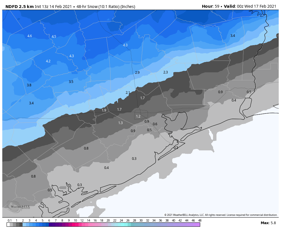
On Sunday evening, the atmosphere is unlikely to be below freezing all the way up, so I think most areas will see a glaze of freezing rain fall before it turns to snow. We’re now reasonably confident that areas north of Interstate 10 will see on the order of 1 to 4 inches of snowfall by around mid-morning on Monday. We’re less certain what will happen closer to the coast, where there may be enough lingering “warm” air from the Gulf of Mexico to produce sleet or more freezing rain rather than snow.
The forecast models now suggest this precipitation will end by mid-morning, as the atmosphere dries out. We still can’t have complete confidence in what area roadways will look like, but the potential for a glaze of ice on the surface, covered over by snowfall, is a rather dangerous one. You should be prepared to not go anywhere from Sunday evening through Tuesday morning. Some major roadways may be cleared by authorities, but this kind of winter storm is unprecedented in recent decades because temperatures on Monday will not get high enough to melt roads. Rather, daytime temperatures will remain in the low to mid-20s. So anything that falls, will stick.
Monday night and Tuesday
We still have lots of questions about the severity of cold weather on Tuesday morning, but if the snowfall forecast verifies for Houston it will amplify the cold weather. The combination of snow cover, light winds, clearing skies and an Arctic air mass is pretty much about the most ideal conditions you could conceive for cold temperatures in Houston. However if the region gets more sleet or freezing rain, and clouds linger, temperatures could be somewhat warmer.
As a result, I think we’re looking at a range low temperatures from 5 to 15 degrees for western Harris County and Montgomery County, 10 to 20 degrees in central Houston, and 15 to 25 degrees along the coast. As Matt discussed yesterday, this would be a historic cold snap for the region.
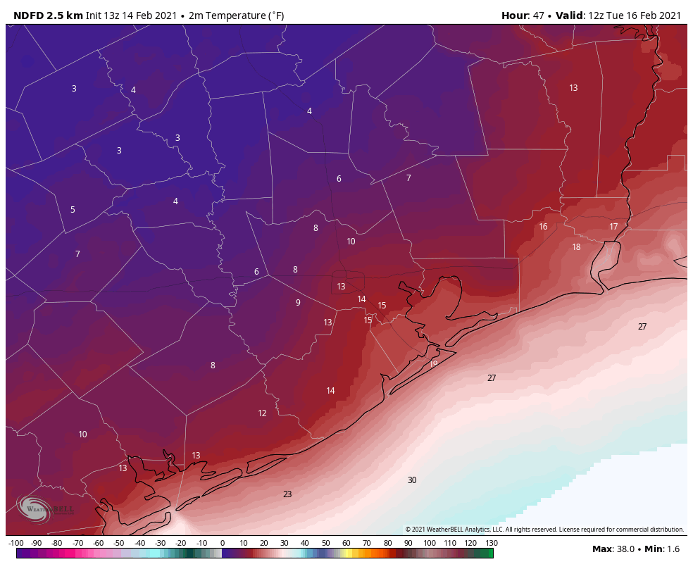
Another question we have is where temperatures may briefly rise above freezing on Tuesday. The coast is a definite yes, where highs may reach the upper 30s. Many areas south of Interstate 10 may briefly see highs of 33 degrees or slightly warmer. I do not know whether this, in combination with mostly sunny skies, will be enough to melt and dry roads. Much of the region north of Interstate 10 will remain below freezing during the daytime. Temperatures Tuesday night will only drop a little bit below freezing.
Wednesday and beyond
Part three of our collision with winter will come later in the week. Yet another storm system will approach from the west early on Wednesday, and it will draw Gulf moisture into the region. Much of the Houston metro area is likely to see another 0.5 to 1.0 inch of precipitation on Wednesday. This may start out as freezing rain early in the morning, but as daytime temperatures climb to about 40 degrees, it should turn to rain. This should also melt any lingering ice on roads.
However, temperatures on Wednesday night will probably drop below freezing for everywhere but the coast, so this sets up a situation where roads are problematic again on Wednesday night and Thursday morning due to ice. We’ll have to nail down these details in the coming days. Highs Thursday should rise above freezing and will hopefully melt any ice on the roads, but we’re going to remain close to freezing. Again, details to come on this.
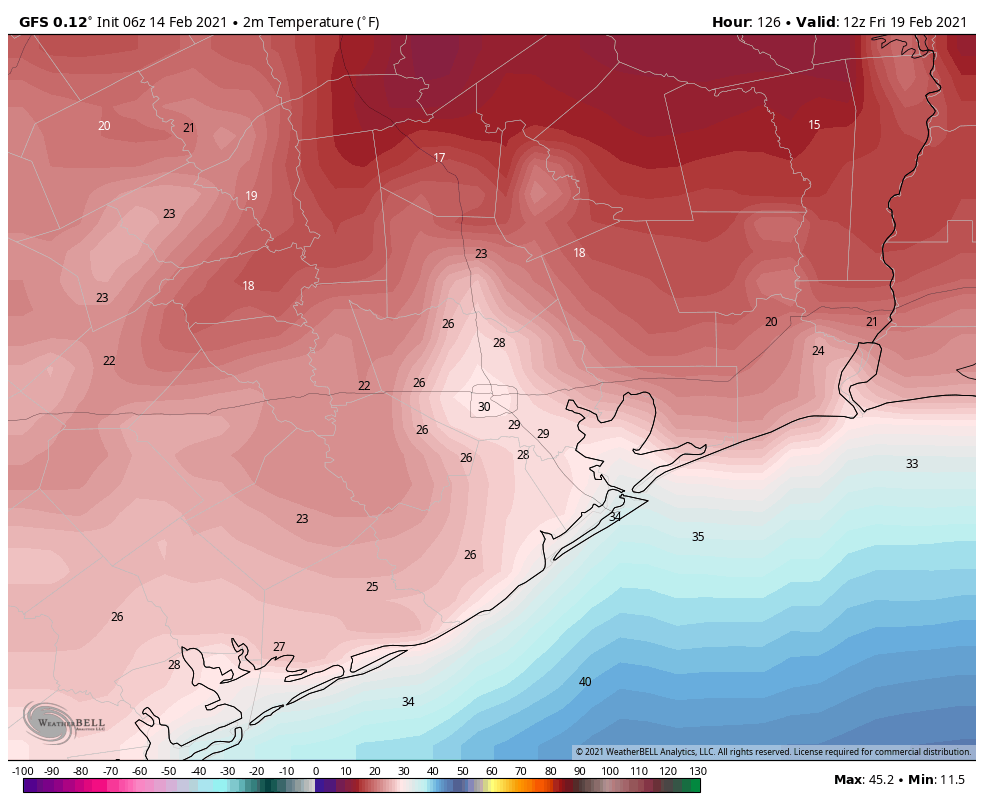
Highs Friday should finally push at least into the mid-40s, with sunny skies. That will be the end of the winter storm. By Saturday, we should be into the 60s.
Final preparation tips
These suggestions were provided by Jeff Lindner, a meteorologist with the Harris County Flood Control District.
PIPES: Protect all and any exposed pipes, shut off and drain sprinkler systems. Open cabinet doors and closet doors to get as much heat against outside facing wall pipes as possible starting Sunday night. In some cases the best course of action may be to shut off water to a structure and drain pipes overnight when water usage is low to avoid pipes freezing and bursting.
PLANTS: Heavily cover and protect any tropical vegetation, citrus, or vulnerable plants. Given the intensity and depth of the freezing conditions this will likely be a killing freeze for much of the tropical landscape of this region.
PETS: Pets and livestock should have proper shelter, feed, and water. Normal water supplies will likely freeze over including stock ponds and lakes.
PEOPLE: Persons should plan to limit outdoor exposure Monday and Tuesday as wind chills will be dangerously cold for our region. Prolonged exposure could result in frostbite and hypothermia. Please ensure your neighbors have adequate heating.
Matt will have our next update on the site by around 4 or 5 pm CT today.

Happy Valentines Day. Thanks for the information and weather. We count on ya’ll. Bless you all.
Thanks Eric for the update! Appreciate everything you do!
From past experience, one problem with draining your system is low spots which will still freeze and could burst (especially) PVC piping, and the possibility of freeze and rupture of the outside line below the shot-off valve.
Also, please inspect your indoor pipe insulation. I discovered several spots where the local squirrel population had bared the pipe for nesting material.
For one, I am MORE THAN TIRED OF OUR CONSTANT “HISTORIC” WEATHER!!!
Many thanks guys for everything. I really appreciate the commentary of if this, then that. It helps me to think about what my plan options could be.
If this was 2020 I’d say “I am so done with this year.” but alas this is only the start of 2021.
“ In some cases the best course of action may be to shut off water to a structure and drain pipes overnight when water usage is low to avoid pipes freezing and bursting.”
Can you please update this for your readers? In some cases? What cases are we talking about? This is unhelpful without specificity.
One way to keep pipes from freezing is to keep water running. That’s why it’s pretty rare for incoming household water pipes to freeze up, as there’s usually some running water. Pipes w/o running water are more likely to freeze up, and should be covered/heated.
I would guess this would be referring to some sort of an out-structure, like a shed or barn, where water usage is low and/or not necessary.
This is what we are going to do overnight tonight and Monday just to be safe. If there is water moving through the pipe, it will be fine and won’t freeze, but anywhere there is standing water in a pipe exposed to cold air, it could freeze and expand and burst. During the day with taps and toilets coming on and off, the water is sufficiently moving but at night when it is colder and the water isn’t moving, it is more likely to freeze in the pipe when it is this cold. Most houses in our area simply don’t have the kind of insulation and pipe protection like they do in colder parts of the country. If you do have your water on during the day, leave an upstairs sink or bathtub trickling at the very end of the line.
It’s best to turn it off at the street, but your house should have a valve somewhere just inside the wall where the water enters the structure. You can turn it off there, just be sure that the above ground portion is insulated and sufficiently warmed where it enters into the valve. The portion of the supply line that comes from the street should be about 2 feet below the surface, so it is unlikely to freeze during the duration of this event.
Once you’ve turned the water off at the street, find your hot water heater and turn off the outlet valve so water stays in the tank the whole time, then turn the temperature down to the lowest possible setting and leave it there until you are ready turn all the water back on full time.
To drain your system, once the water is turned off, open a tap (or multiple taps) on the ground floor and let it run until it stops. Then do the same thing for all hose bibs on the outside. (Remove the hoses first).
Also be sure to fill your bathtubs with water before you turn it off. Then you can use a bucket to still flush toilets when necessary. You would also have drinking water from the tub if you need it. (Use a clean bucket!)
To turn the water back on, do all of these steps in reverse.
Normally I wouldn’t do all of this during a “normal” cold snap, but this situation is serious and severe enough that the risk of pipes bursting in one’s attic or crawlspace is very likely. The cost of repairing a burst pipe is extremely high, both in time and money and inconvenience, so the inconvenience of not having running water for 12-24 hours is relatively minor compared to that.
“Most houses in our area simply don’t have the kind of insulation and pipe protection like they do in colder parts of the country.”
Indeed. Watching a few neighborhood houses built over the years, and noticed that water lines are often barely buried, if at all (most seemed to have a layer of sod, nothing more, over the lines).
A recipe for disaster.
Grow up, Idiot. Make your own decisions. Be a man, not a sleaze shit kicker.
Any idea about Beaumont’s weather for Sunday thru Monday PM ?
THANKS
Thank you Eric and Matt for all you do. What’s the best Wi-Fi name you’ve seen?
When you say “coast” I question whether you mean Galveston or if this includes anywhere on the inside/inner bay area as well. Like my parents live in Taylor Lake Village (Seabrook), but it’s right off Mud Lake/Lake Pasadena/Clear Lake area and not the actual Gulf; and we are a little further in very near the Spaceport. Would both of our areas be close enough to be included as coastal, or just my parents? Or is this just a Galveston reference?
I always read the forecasts and try to figure out which applies best to our location. Maybe others have the same question. We just have inner coast areas and then of course Galveston way out there.
Please people don’t go out tonight! Worried my husband will be stuck at work tonight, or worse on the roads because they still have people confirming their 8-10 pm reservations.
This should kill off the insect population for awhile, until those insects who sheltered in warm pockets multiply again.
which will take a couple months…
Any thoughts or recommendations on when to drip faucets?
Back to the basics , leave your water dripping out of a faucet over night and you’ll be fine . This is not a disaster storm like they have in many other states where temperatures drop 20 below zero and yet they just leave there water dripping .
Now driving on the roads with potential ice is dangerous because of our moisture , dew points and sea level, the water will freeze faster on the roads then it does in other states , not to mention we do not have the man power nor the equipment to prepare our highways as they do in other states that have a usual winter storm half of the year .
You should flip the wipers up off the windshield of any vehicle left outside…especially the rear wiper.