I hope everyone got through the weekend of Saharan dust without too much trouble. We saw a bit of improvement to air quality on Sunday, and we will see further improvement today and tomorrow. It may be unnoticeable by Tuesday. Then we’ll talk rain.
Today & Tuesday
Other than the lingering dust, today will just be another hot one. Look for highs to top off in the mid-90s in Houston, a bit cooler near the coast and hotter inland. It will be mainly sunny. Tuesday will start off similarly. Expect a few more clouds to roll in during the afternoon however. There may be a shower or storm around east of I-45 later in the day. But for the most part, I think Tuesday during the daytime looks good. Any organized storms on Tuesday will be in Louisiana or near Beaumont/Port Arthur. If you’re traveling I-10 east toward Lafayette or Baton Rouge Tuesday afternoon or evening, leave yourself a little extra time.
Fourth of July
Here’s where things get slightly more complicated. We’ve been discussing this since last week, and we have slightly more confidence in how things should go today. A vigorous upper level disturbance will swing across the Gulf Coast Tuesday and into Texas from east to west Wednesday and deliver showers and thunderstorms. Let’s roll through what we expect.
Timing: The start time in the Houston area will vary, but I expect an increasing chance of thunderstorms or showers from east to west on Tuesday night, sometime around and after Midnight, lingering into early afternoon on Wednesday. I think our odds of improving weather go up after 12-4 PM on Wednesday (again from east to west).
Do I need to cancel my plans? If you have July 4th evening plans, I would keep them, as the timing may work out well for fireworks and evening events. The morning and early afternoon will be dicier, so for some area parades, that could dampen things. If you have morning or early afternoon outdoor plans, you may want to have an indoor backup ready to be safe.
How much rain will fall? I believe we should see, on average, one to two inches of rainfall on Tuesday night and Wednesday. There could be a few places that see up to three or four inches of rain, or even a little more.
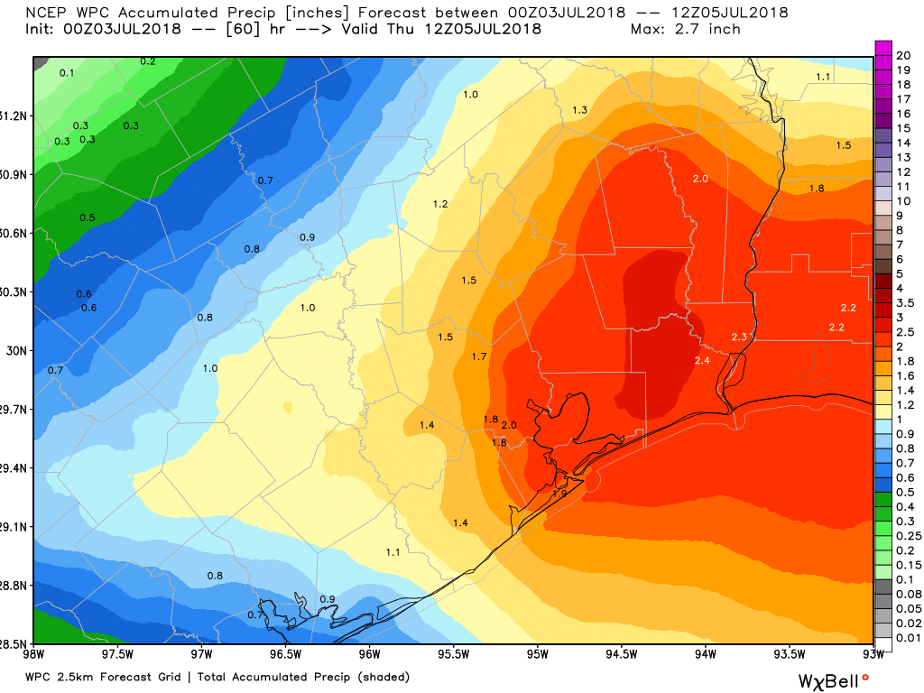
Flooding? Major, widespread flooding is unlikely from an event like this. As is often the case in Houston in summer, however, street flooding could be an issue in the morning or afternoon, depending on where the heaviest rains occur. Right now I think the most likely window for heavier rain from this system will be from 6 AM through 2 PM Wednesday. That may shift a bit between now and then, however.

Where will the heaviest rain fall? It’s still a little too early to say if the heaviest, most persistent rain is in Houston, just east, near the coast, or somewhere else. And that could mean that the morning of the Fourth isn’t so bad in some spots. But we just can’t tell you where those are located. Hopefully we’ll have a better idea tomorrow morning.
Temperatures? With the rain, we’ll probably see high temperatures stay below 90 degrees on Wednesday unless the rain ends early enough and we can get more sunshine than currently expected.
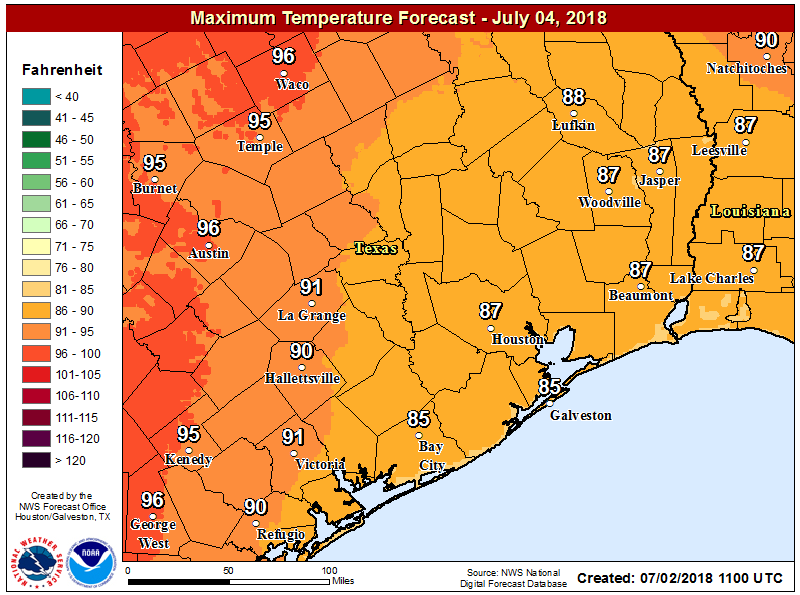
Some places may not even get out of the mid-80s on Wednesday. Evening events will probably see low-80s in most spots.
I’m traveling on Wednesday. Will there be flight delays or what time should I leave? It’s possible we see some sporadic flight delays on Wednesday, especially in the morning and early afternoon. As for when you should leave if you have to drive somewhere Wednesday, we can’t tell you. But again, the best chances for rain will be in the morning and early or mid-afternoon.
Anything else we should be concerned about? I wouldn’t rule out a handful of stronger thunderstorms Wednesday morning through early afternoon with a good deal of lightning and gusty winds. But those should be fairly isolated and the biggest impact with this system will be locally heavy rainfall.
Thursday and beyond
Broad onshore flow will persist into the weekend, as the high pressure system responsible for record heat in the Northeast shifts into the Rockies for late week. This means we will be exposed to some additional disturbances and higher than average rain chances as we head toward the weekend. Thursday may not be so bad, but Friday through Sunday look to see decent scattered rain/PM thunderstorm chances. We may turn a bit drier again next week. Temperatures will be held down a few degrees due to clouds and rain chances this weekend. So instead of 94-96° every day, we’ll probably drop back to 91-93° on average, if not a bit cooler on a day or two.
June in review
Thanks to the warmest average nighttime lows in June on record in Houston, we finished with the 6th warmest June in Houston’s weather record history. Houston’s weather records go back to 1889. Our average temperature last month was 84.9°, which was just beat out for fifth place by 1980, when 85.1° was the average. Galveston recorded their 5th warmest June on record, and College Station finished in a relatively mild 12th place all-time. It’s been a very hot couple of months. Galveston has had their hottest May-June on record, and Houston only trails 2011 for warmest on record. It’s been a blistering summer so far.
Matt –
Thanks for the July 4th forecast.
Can you tell me exactly how much it will rain in my back yard at precisely 4:02 PM when I plan to have the first burger come off the grill? I’m sure my guests would be disappointed if they were wet.
Also, do I need to cancel my flight? And will my daughter be able to drive in from Rosharon? She’ll be using 1462 aroound 2 PM. And will my dentist be able to make it in for my root canal on Thursday? Thanks.
(Just trying to save you some time up front answering the questions that will start flooding in.)
Sorry, the reports only cover the front of your yard, and no later than 3pm. Nothing for your dentist.
After watching Back To The Future 2 as a kid, I was disappointed that we didn’t have second-by-second weather forecasting by the year 2015. And, and no hover-conversions for our cars either. . . .
Exactly.
I’m on here everday and it blows my mind to read the comments that people repeatedly ask, expecting a personal forecast (as you’ve comically mocked). After reading today’s overly explained weather forecast, it shows how Matt and Eric are trying to appease (and thwart) the nonsense that has come from so many recent commenters. I feel bad for them trying to answer impossible questions all the time. Hopefully this extremely precise forecast will keep those comments at bay.
Come here for the excellent and detailed forecast. Stay for the comments 🙂
I agree with the silliness comments. If that the weather discourse you wish to partake in, The Weather Channel has an ENDLESS amount of idiotic silliness just for you!!
Matt, I saw your comments on traveling to Louisiana tomorrow evening.
I am actually heading out to Florida tomorrow evening around 6 pm.
Exactly what type of rain/storms should I expect to see along the way and will this cover multiple states? If it’s a really bad patch of rain that is going to last from Louisiana to Alabama, then I may need to leave at another time.
Thanks!
I am glad that I bought my rubber raincoat, quite stylish and useful, unlined for warmer weather, but big enough to layer underneath in the cold. It always rains here, so be prepared.
Okay – Tomball is cancelling their July 4th activities… something doesn’t jive, https://communityimpact.com/houston/tomball-magnolia/city-county/2018/07/02/breaking-tomball-cancels-annual-july-4th-festival-citing-inclement-weather/
Good excuse to save some money.
Thanks for posting this and Best Regards
I wasn’t able to come by this post on time for Independence day but I love the details you were able to provide on this. I didn’t know street flooding could be an issue also it’s cool that we are able to plan ahead should stuff like that occur. Thank you so much for the informative post! Would have been really helpful if I came by this earlier.