We’ll dive into the forecast for the Fourth of July in a moment. Houston has been plagued by July and August-like heat often since May. Now that we’re in July, the good news is that, at least for a short time, we will reverse course a bit. It will still be hot, but it will actually feel more like May or June than July.
Today
Off the bat, I think today will be mostly trouble-free. Again, if your plans take you east of Houston toward Louisiana, you’ll likely run into showers and storms a good bit of the way beyond Beaumont. Here in Houston, it will be partly to mostly sunny through early afternoon, though clouds should increase later in the day. High temperatures will surge back to the mid-90s once more. I wouldn’t rule out scattered showers or storms later this afternoon or evening for places primarily east of I-45.
Tonight
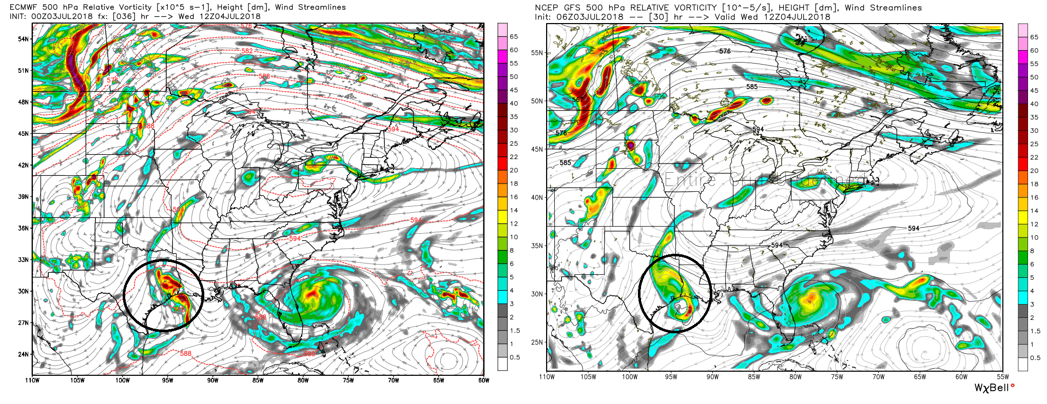
Our upper disturbance will approach the area later tonight. Ongoing showers and storms in Louisiana may try to hold together as they move into Texas late. Our weather models are somewhat divided on solutions overnight tonight. Possibilities across the Houston area range from “mostly nothing” to “you’re probably going to be roused from slumber at 5 AM because of thunder.” Weather models generally handle these scenarios with mixed results, so there’s a healthy degree of uncertainty here. The radar isn’t exactly lit up in Louisiana this morning, so perhaps this suggests we will need the sun to come up before we get much activity.
But when I look at the “big picture,” meteorologically, I see a strong disturbance approaching overnight. To me, this argues that showers and storms will become more and more likely as the night goes on.
I would not at all be shocked to see the “roused from slumber” solution win out for some of us. If storms do keep going overnight, it’s not a lock that the entire area would be impacted by them.
So I’ll go with this bottom line tonight: Scattered showers and storms become increasingly likely as the night goes on, with highest odds east of I-45. Expect low temperatures to bottom out in the mid- to upper-70s where it doesn’t rain, and mid-70s where it does.

Fourth of July
Wednesday’s forecast will obviously be contingent on what’s going on at sunrise. If we have widespread storms ongoing, we’ll see them end toward midday and the rain threat drops off as we approach evening. If we don’t have sunrise storms, I think we’ll see increasing storm chances through the morning, peaking around midday and then dropping off toward evening. Both scenarios argue for storm chances dropping off toward evening, so that’s good.
We covered a lot of the Q&A in yesterday’s post, and for the most part, the story remains the same. The bullet points:
- Showers and storms most likely from morning through early afternoon, with gradually diminishing chances from east to west thereafter.
- It’s possible not everyone sees heavy rain and that some places don’t have a lot of storms.
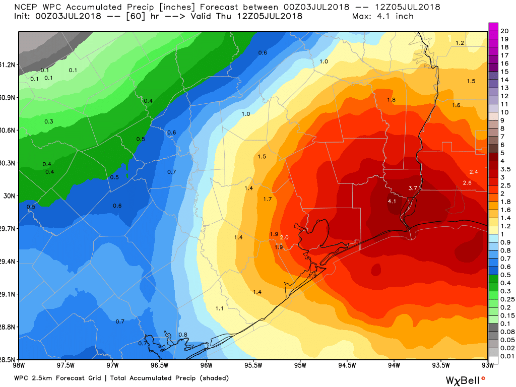
- On average, we’ll call it 1-3″ of rain, with isolated higher amounts in smaller areas.
- Localized street flooding is possible, but serious, widespread flooding is not expected.
- Some of the storms could be strong, with frequent lightning and gusty winds, but a widespread severe weather event is not expected.
- Temperatures will be cool for early July, with highs likely struggling to get to the mid-80s in many spots.
I’ll try and tackle some questions in the comments later today, but I’m hopeful most of them are answered here.
Evening festivities should see a lingering shower west of Houston, but otherwise it will be partly to mostly cloudy with a damp ground and temperatures in the low-80s or even some upper 70s.
Thursday & beyond
Rain chances will stay elevated from Thursday onward. The pattern stays active, with additional disturbances (likely weaker than the one we see tomorrow) passing through, especially on Friday and again sometime this weekend. Each time one passes, it will likely help to produce more widespread showers and storms. It’s tough to say much specific beyond that.
Temperatures will be held down because of clouds and shower chances with high temperatures varying between the upper 80s and low-90s, which is more typical of the end of May or June than July. The active pattern could settle down a bit after Monday or Tuesday of next week, and we would probably resume hotter weather.
Thanks for all the great reporting that you do! Do you have any more information on the African dust? I’ve heard both that we’re well past the worst of it, and that there’s another band of it coming in today.
The worst is done and whatever is left should be gone after tomorrow AM. We won’t be back to what we saw this weekend for some time (if at all). There’s a chance we’ll get back into some lighter dust concentrations next week or weekend, but it’s too soon to say much more. Either way, it wouldn’t be as bad as what we just went through.
Thanks!
Will any of that moisture head up to San Antonio area? We’ve permanently escaped from Houston and missing y’all’s excellent forecasts.
It’ll be a close call in San Antonio. I might have favored Austin for seeing storms than SA this morning, but new data seems to imply SA will get in on the rain at some point in the early to mid afternoon.
Well that’s just ducky!!! The rain is going to be in MY area of the world….. oh well, guess it’ll be great sleeping weather!! 🙂
I would just note the uncertainty. GFS predicts 1-3″ in Harris County tomorrow. Euro model predicts 4-5″ which would make the street flooding much worse. NWS discussion:
“ECMWF/NAM/ARW/NMMB group show the inverted trough progressing farther inland and strengthening. On the other hand, the GFS is keeping the inverted trough weaker and displaced closer to the coast. The first group of models have attempted strengthening this system multiple times already to no avail, so at this time, the weaker solution was chosen with storm total precipitation of 1-3″. Higher amounts of 4-5″ will be possible with any banding or training of storms, as well as if the system progresses farther inland.”
Probably resulting in a total power grid collapse and resultant zombie apocalypse….oops did I say that?
No but your beer keg might float away.
I didn’t understand one bit of that…. LOL LOL LOL…. meteorology is definitely not my skill set – that’s why I only pay attention to Eric and Matt…. they talk to me in language I can understand… cause I just ain’t that smart! 🙂 🙂 LOL LOL
There’s some uncertainty on specifics, but the general idea of a moderate rain event with some localized street flooding (and not widespread flooding) is pretty consistent.
We were planning to to drive from Austin to Houston tomorrow morning— should we consider changing our plans? Thank you!
I can’t tell you if you should change your plans, but I think in general, the earlier you’re able to leave, the more likely you’ll be to drive out of the heavier rains. It’s entirely possible that the trip out 290 or 10 to 71 will be fine. But each hour you wait, the rain chances increase.
Looks like I should get out the “dog child’s” Thunderjacket just to be safe
There is only one way to approach the potential rain this 4th.
I’m flying back into town Friday night. What are the chances my flight is t delayed or canceled?
My gosh…what just came thru Ellington Field area was insane. You guys on the west side brace for a serious light show, wild winds, and heavy raindrops that sound like hail. The sky turned orange/yellow and let loose a fury shortly after. Calmer now, but still a ton of lightning. Power went off and on multiple times.
Nevermind, looks like Ellington got it’s own personal raging storm with 26 mph wind and 46 mph gusts. It’s heading more southwest than west. https://www.weather.gov/hgx/