Good afternoon. The purpose of this post is to emphasize that while we have a pretty good handle on the forecast for Tropical Storm Nicholas over the next 24 to 36 hours, after that many questions remain. And for this reason, we want readers to understand that while Houston may see heavy rain over the next three days, other parts of the state are very much at risk as well.
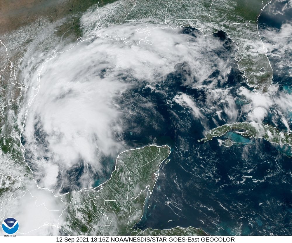
As of 1pm CT, Nicholas still has 40 mph winds, and it is moving north-northwest across the southern Gulf of Mexico. Winds from the storm may reach South Texas by Monday morning, and the upper Texas coast by around Monday night. It’s possible that Nicholas becomes a Category 1 hurricane, and there will be some effects from this wind and surge. However the greatest threat remains rainfall, so that’s what we’ll now discuss.
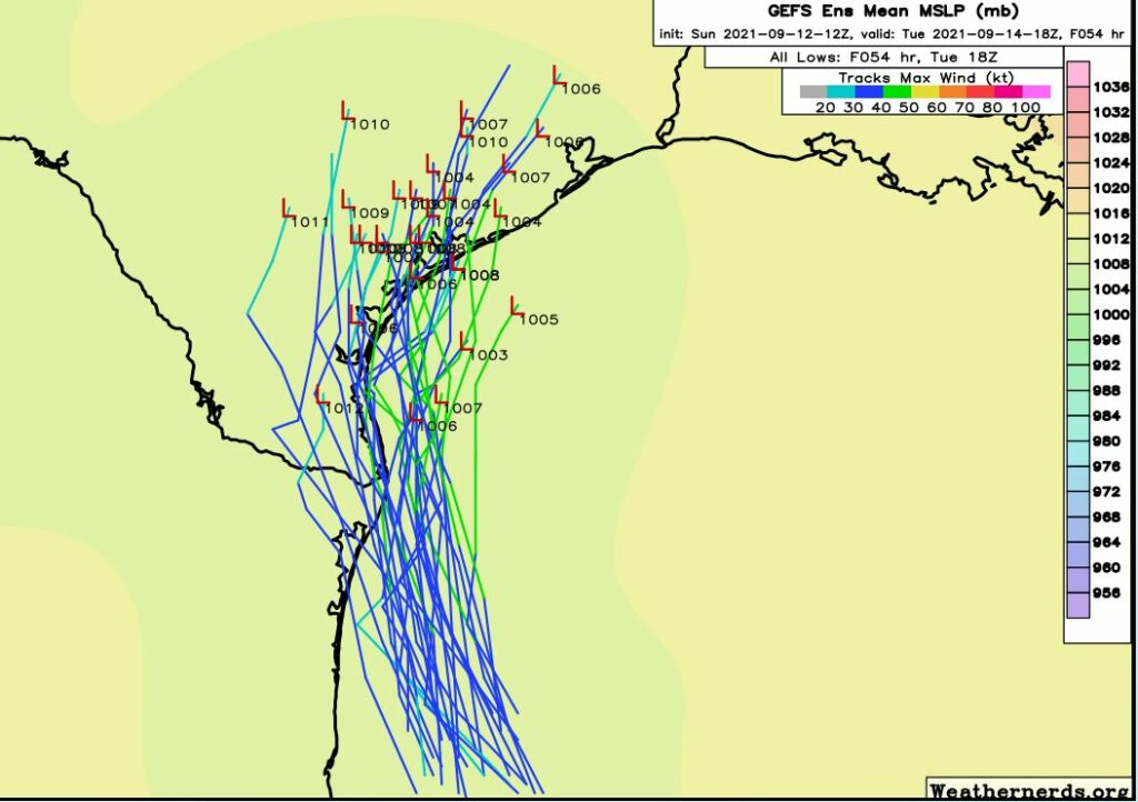
I know you’re tired of reading about “uncertainty,” but you’re going to have to bear with us for another 12 to 18 hours on that score. Why? Because Nicholas only now is beginning to develop a reasonably well defined center of circulation, and we’re starting to get better data from reconnaissance airplanes flying into the storm. This improved information will be fed into models. So the computer model outputs after 6pm today will be better, and then models released after midnight tonight should be pretty good. The bottom line: When you wake up on Monday, we should be able to give you a more precise forecast.
In the meantime, it’s important to stress that the greatest threat for heavy rainfall and flooding is not coming on Sunday night Monday, but rather Tuesday and Wednesday as the center of Nicholas moves into the Texas coast. After that, the rains will be largely dependent on the track of the storm—which again we should have a better handle on by tomorrow morning.
Put more explicitly, it is quite possible that some location in Texas inside a triangle from Austin to Corpus Christi to Beaumont sees 20 or more inches of rainfall on Tuesday or Wednesday. (Most areas, of course, will see considerably less). I still probably would favor the Houston, Galveston, or Beaumont regions for the heaviest rainfall, but we just cannot say for sure. So what should you do in the face of this uncertainty? Well, if it helps, you can blame us. But what I would advise is keeping an eye on the forecast, especially tomorrow, when we should have a better handle on things. And then be prepared for the potential of flooding on Tuesday or Wednesday.
Matt will have another update on the situation this evening, before 9pm.
20 inches…
That hurts.
TWSS
Best forecast I’ve read, ever.
Well, crap
Any chance of it stalling out like a Harvey?
My thoughts exactly Harvey did this same exact thing we thought it was just a Tropical Storm them bam we got hit with a Cat 4
I really appreciate the information. It is very professional, but also personal. Thanks. I understand the difficulty of being precise. No need to apologize. You guys and gals have a difficult job. Be safe, take care. Dr. Fuentes.
No way! That was a once in a thousand year storm. Very unusual. Besides, this one is moving 13 mph so, after a day it will be out of the area.
A thousand years is now every other year
Thanx. Ya’ll are the best, and so appreciate the updates. We will just wait and see snd pray.
Take care & God bless Ya’ll.
Don’t worry about the uncertainly, just knowing what is and isn’t realistic is what’s important to me at least
Have a flight from Hobby Tuesday morning at 9. What do you think the odds are of that flight being cancelled? Trying to decide if I should change to leave Monday. Thanks so much for all you do!! Yall are my first choice for weather info!!
I’m no expert but if you really want to get out, change to Monday.
In Microsoft Excel, Odds of flight being cancelled = RAND(). We simply don’t know.
Yikes – looks like the Euro got it right. Was hoping for a more east landfall so we could get the clean side of the storm, but appears unlikely now.
Euro model is always correct, american model sucks due to cost cutting
Can you tell us what stage this might be on your SCW flood scale?
They had said, I believe it was yesterday?, a Stage 2 event. But I’m not sure if they have updated or anything as far as that goes. 🙂
Should we worry about the winds, do we need to bring in things that could fly around?
My parents and I put away small things that could blow around. Large heavy items stay in place.
So are yall keeping the flood risk as a stage 2 or bumping it up to a stage 3
Please spare Rockport. Our house is still under repairs from the flood in July 7, 2021. We just finished sheetrocking. 😭😭😭
I pray that y’all are spared.
I will be praying for you im not too far from you im in Goliad and Harvey hit us pretty hard as well.
It’ll be Beaumont that sees all the rain 🤦🏻♀️ You would think we’d be used to it by now.
Lately it seems like these storms are almost on top of us before we have enough info to make decisions on whether or not to leave home to drive a couple hundred miles to higher ground..After today, if one wants to leave, the driving will be more treacherous, in heavy rain 🙁
I agree with you Lisa. Look how little time people in Louisiana had to get out. I feel as well we are not getting enough precision on these storms before it’s right on top of us.
Looks like it’s going to dump the heaviest rain on us after all! Thank God we live 3 floors up. Praying it doesn’t slow at any point!
5 INCHES.
All I can say is all those in the path of all the rain, be safe and I hope there is no major damage to your homes.
As for myself, I live well inland (Northwest part of Harris County) and we are expected to get 2-4 inches of rain.
If a strong tropical storm or Cat. 1 hurricane hits the Texas Coast and then moves off to the northeast, it would be helpful to know how quickly it will move away because that will determine how much cumulative rainfall we get. TS Allison and Harvey lingered, which caused massive flooding in the Houston area. At this point, do we know what scenario is likely to happen after landfall?
I cleaned out my yard drains today so I am ready, right after a quick trip to Spec’s
In case the world runs out of hand sanitizer during the storm, right? 😉
I live on Galveston Island, behind the seawall, and have read the Hurricane Local Statement. Trying to figure out if it’s worth the hassle to board house windows, or if putting away all loose stuff should be sufficient?
Great! We are on vacation in the Florida Keys. Wondering if flights will be cancelled tomorrow evening ….
What do they say for Katy as far as rain goes?
You need to be specific. Which subdivision in Katy and nearest cross street, during which time? Please be as specific with a 20 minute interval so your question can be answered please.
Flying out of Bush Wednesday evening. Think the system will have moved out by then?
I think I’ve just had a realization. Are all of these airport questions another joke like the evacuate Katy thing?
9pm ? The updated model runs with the hurricane hunter data won’t be out until 00z ! All a 9pm report will do is to repeat what as been said all day.
Yeah well they have to work with what they’re given. Seems you’ve probably never been in a similar position.
What will things look like for people down in the Victoria area?
Should we board up our windows?
Thank you so much for all your work and service to us
Does it look bad for New Waverly?