We continue to monitor Invest 94L Potential Tropical Cyclone 14 Tropical Storm Nicholas in the Bay of Campeche, which is likely to become a tropical storm before the day (or possibly the morning) is out. As I write this, hurricane hunters are investigating the storm and they have found tropical storm force winds, and subsequently they have tagged this as a PTC, as it lacks a defined low level center. In other words, it quacks like a duck but it doesn’t yet look like a duck, so we can’t technically call it a duck. But from your perspective, it’s basically a duck. Sorry, Ohio State fans.
Nothing better than writing a bunch of stuff only to have it get blown up. Anyway, we now have Tropical Storm Nicholas. Here’s the forecast track from the National Hurricane Center.
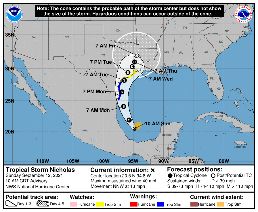
With the formation of Nicholas, we now have Tropical Storm Watches along the coast and in Galveston Bay. The initial read on Nicholas from the NHC is to strengthen it to a moderate to strong tropical storm before making landfall somewhere between Rockport and Sabine Pass. The Matagorda area is favored at this time, but that could always change.
From our vantage point: First, we will be holding this at a Stage 2 flood event. Given the higher end risks and uncertainties involved in this forecast, it’s important to note that this is pretty low confidence. We would continue to skew this as lower risk for a Stage 2 event north and west of Houston and higher risk south and east. In other words, the farther south and east you are in the metro area, the more likely you are to receive heavy rainfall that could produce flash flooding. Or at least that’s our going assumption sitting here today.
Sunday/Monday
Next, let’s talk briefly about today and tomorrow. We are expecting thunderstorms at times, especially along the coast. And those could easily produce 2 to 3 inch per hour rainfall rates which could cause flash flooding eventually. It’s important to note that this rain today and tomorrow is indirectly related to Nicholas, and what we see on Tuesday into perhaps Wednesday would be directly related. In other words, we are expecting multiple rounds of rain and storms between now and Wednesday. If you don’t get rain today or tomorrow, that doesn’t mean you won’t on Tuesday or Wednesday and vice versa.
The Weather Prediction Center arm of NOAA has placed the southeast metro in a slight risk (level 2 of 4) of excessive rainfall today and the bulk of the metro area in that slight risk tomorrow.
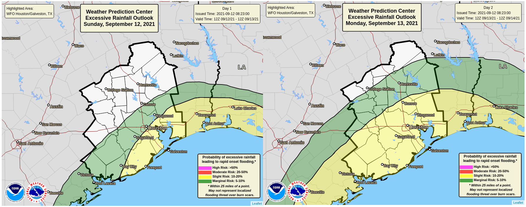
This means that there is at least some chance that we get enough rain to produce flash flooding in spots today or tomorrow. Rain will likely fall at the rate of 1 to 3 inches per hour in the heaviest storms, and any storms that linger awhile or “train” repeatedly over the same areas could begin to produce some street flooding. This would be most likely at the coast or just inland today and tomorrow, but some risk exists farther inland as well tomorrow.
How much rain do we expect today and tomorrow? Well, here’s the official NWS outlook for rainfall through Tuesday morning.
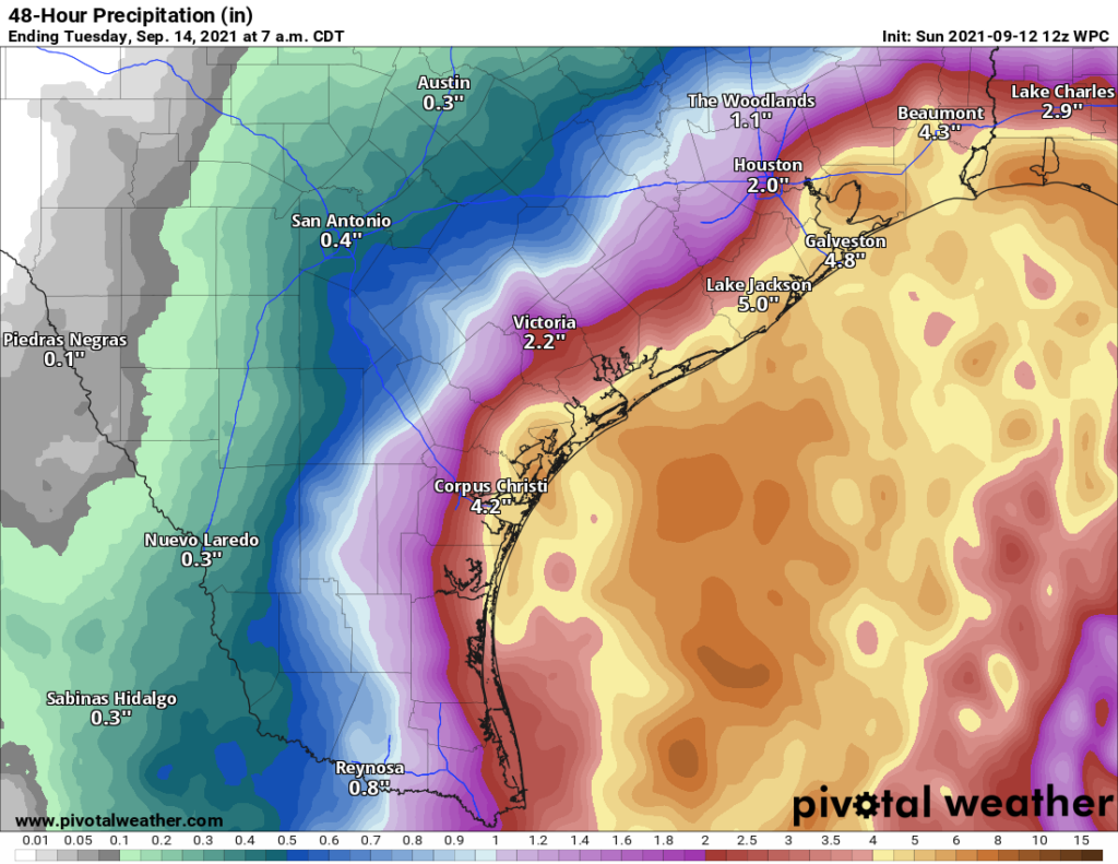
We would expect to see about 3 to 5 inches of rain along the immediate coast with 1 to 3 inches inland. There will likely be isolated higher amounts in here — through late Monday night or Tuesday morning.
Beyond Monday night
Here’s where forecast confidence drops a good bit. When we have tropical storms we often tell you not to focus on the center line because impacts will extend far from the center. That’s as true as always with this storm, but the reality is that: Because of the angle at which this is coming up the Texas coast, that track actually really matters in terms of what we experience in the Houston area and coast on Tuesday into Wednesday. Why is this? We can look at two goal posts here to get a sense of why this is important.
Last night’s GFS model took the storm into Cameron Parish, Louisiana and because it spent a lot of time over water, it basically intensified it into a hurricane. But! Because it tracked offshore, the bulk of the tropical storm and hurricane force winds stayed offshore, and Galveston saw just moderate tropical storm conditions. The Euro brings the system inland over Matagorda and because that’s far enough south Galveston again just saw moderate tropical storm conditions on that run. But from a rainfall perspective, the farther east GFS directs most of it into Louisiana, while the west tracking Euro brings it more into the Houston metro area.
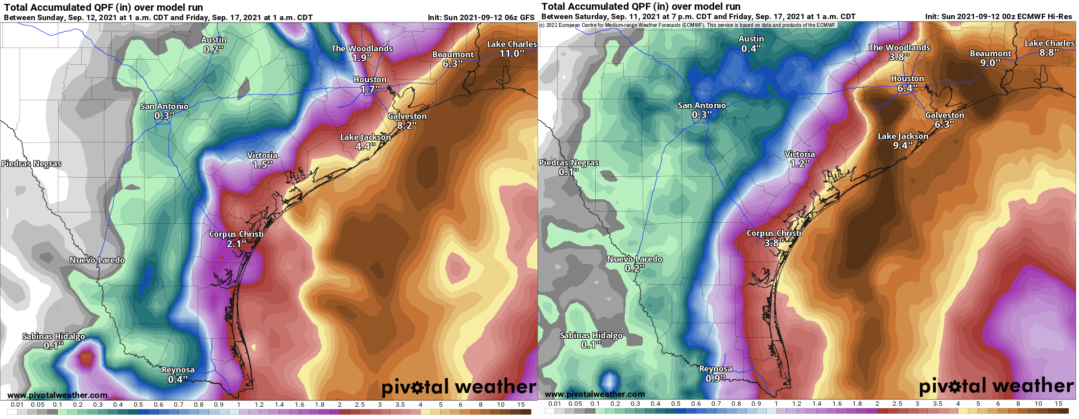
The final track of Nicholas will be dictated by where exactly the low level center forms. So in terms of Houston rainfall, a solution like the GFS provides minimal impacts Tuesday and Wednesday, whereas the Euro implies significant risk of flash flooding. It’s important to note that both solutions imply heavy rainfall risk is likely along the immediate coast, so for places like Galveston, you should expect at least another period or two of heavy rain Tuesday into Wednesday regardless of the exact track.
The good news is that with a defined tropical storm now and hurricane hunters continuously investigating, and better data going into our models, we should have some clarity on this by tonight, or so that’s the hope!
In terms of tropical impacts: Based on the track above. Winds will likely approach 30 to 40 mph at times beginning late Monday night or early Tuesday along the coast. Winds will likely be sustained at 30 to 45 mph on the coast Tuesday, with gusts of 45 to 55 mph possible. Higher winds are possible with a stronger storm or one that splits the model difference right now and comes ashore near Galveston. A storm tracking farther east would likely result in slightly less wind at Galveston and more impacts to Port Arthur or Cameron, LA. Inland winds should remain below tropical storm force, but it would likely be a breezy day at times on Tuesday, especially south and east of Houston. This doesn’t appear to be a major power outage risk event for the majority of the Houston area, but coastal areas could have a few issues.
Tides are going to approach levels of about 3 to 5 feet above mean low lower water (MLLW). This may lead to impacts close to what you may have experienced during Tropical Storm Beta almost exactly one year ago. This is mostly minor coastal flooding. If Nicholas does intensify beyond current expectations or come ashore closer to Galveston, tides could be a bit higher and flooding would become more of a concern along the bay communities as well as in Galveston, Surfside, and Bolivar.
So just to summarize:
- Periods of heavy rain, indirectly associated with Nicholas are likely today and tomorrow, with the highest amounts likely closer to the coast. Flash flooding is possible with those storms.
- An additional period of heavy rain is likely on Tuesday into Wednesday, contingent on the exact track of Nicholas. That is where we have significant forecast uncertainty still. Additional, possibly more significant flash flooding is possible then.
- Tropical storm conditions are becoming more likely along the immediate coast, with Galveston likely to experience tropical storm conditions on Tuesday. At this time, we don’t expect inland locations, including the city of Houston to see significant wind, though it will be a bit breezy Tuesday.
- Minor coastal flooding is likely, with impacts possibly similar to what was seen during 2020’s TS Beta. A stronger storm or a storm closer to Galveston would likely yield slightly worse impacts, but a storm passing east of our area may reduce impacts some.
- We expect better model data this afternoon and evening to hopefully help boost some forecast confidence.
Eric will have the latest based on morning model data around 2 P.M. today, and we’ll have another post this evening as well.
Thanks to Matt and to Eric for adding extra bulletins as TS Nicholas developed.
As a longtime Houstonian, I’ve learned not to underestimate tropical storms and, after Hurricane Harvey, I’m more nervous at any organized ball of moisture roaming the Gulf.
No need to panic but it is a good time to do some easy preparing and rescheduling a number of things so I don’t have to go out this week.
Matt…WOW! Lots of stuff…thanks for the summary statements at the end…very clear!
You guys are awesome. Just awesome. Thank you!!
Live your information..thanks so very much..don’t want to do a storm without YOU…
Euro models are always pretty good with these storms. Prepping for the heavier rain and hoping for lighter.
Thank you for your great work – really appreciate it!
That’s a lot of information! Thank you. And couldn’t stop laughing at how you started this post. 😂 Beautiful writing and insightful updates! We appreciate you!
Thanks for giving us the facts.
I know you hear it frequently but you guys are just great! While I read the NHC and browse local “forecasts”, I ALWAYS come here FIRST to get the actual lowdown. No hype, no drama, just you interpreting the data and conditions. Gives me a great deal of comfort!
Once again, I am soothed by your no hype forecasts and summaries. As a person that gets extremely anxious regarding storms after Ike, I appreciate the calming effect your words have instead of the DOOM AND GLOOM by the local forecasters that love to spread panic among us. THANK YOU. Looking forward to your next updates.
The “doom and gloom” by the local forecasters are long gone. Not sure why you folks keep dredging this up. I watched several newscast this morning and all pretty much echoed the above post.
I fully agree. When I check the actual information – there is no hype, just data. When I go to any other local news source, it’s magnified, concerning, and dramatic…. You can tell those that watch it typically are very scared. The others are just prepped.
We very much appreciate the straightforward information!
Cue the “this is Harvey all over again” comparisons – thanks for the factual no hype sharing of information. Much needed rain on the way!
Thank you Thank you Thank you. So important now more than ever while climate change so affects us on the Gulf to get as accurate information as possible. Understand the uncertainties and thanks for being so frank and factual.
I am a bit confused here…the Euro model has twice the amount rain currently projected by NWS. Wasn’t it the Euro that predicted Harvey? I would appreciate a technical perspective on how NHC/NWS (and meteorologists) determine potential rain totals when the models are so drastically different.
Nobody likes a tropical storm/hurricane but with you guys we at least no the facts..
Thank you,
Thanks for the warning !
I just got a whole house generator installed by Generator Supercenter out here in Fort Bend County (ordered one week before the Texas Freeze in Feb). The pantry is full of canned goods. We have 30 cases of bottled water in the garage. Going out this afternoon to fill the vehicles to full tanks. We are ready as we can be. Hopefully this will just blow through or around us.