Today, we’re launching a new series: The Space City Rewind. In this series, relying on various resources and historic weather data, we’re going to discuss historic weather events that have occurred in the greater Houston area. Although there are many fine books and articles in print, there’s limited, definitive information online about Houston’s turbulent weather history. We aim to publish informative, detailed, and insightful pieces on such events. With many new readers and residents in the Houston area, it’s helpful to understand our history and the range of severe weather that can affect those living on the upper Texas coast. We’ll talk about the meteorology, impacts, and share some interesting stories and photos.
We begin with the November 21, 1992 Southeast Texas tornado outbreak.
Summary
November 1992 represents the benchmark tornado outbreak for Greater Houston. Six tornadoes were confirmed in the Houston area that day, including an F-4 rated tornado in Channelview. Several other tornadoes spun up elsewhere across Southeastern Texas, for a total of 14 in the state. At one time, three tornadoes were on the ground simultaneously in Harris County. Miraculously, no one was killed, but over 30 people were injured. The twisters caused more than $150 million in insured damage (in 2015 dollars). Roughly 2,400 homes were damaged, with another 450 destroyed. These tornadoes marked the beginning of a much larger tornado outbreak that ended up taking 26 lives across the Southeastern United States and causing at least $500 million in damage (in 2015 dollars) nationally.

Some of the pictures from this event are incredible for this area. The absence of any fatalities in Texas is a testament to good fortune, and really outstanding warnings and analysis produced by the NWS Houston. In fact, at that time, the Doppler radars we currently use (and can’t imagine living without) were literally brand new, and Houston was fortunate to have one installed (fast forward to 2:48 in the video below).
We’ll talk more about the impacts and results in a bit. First, let’s tackle the meteorology behind the storms.
Meteorological Setup for an Outbreak
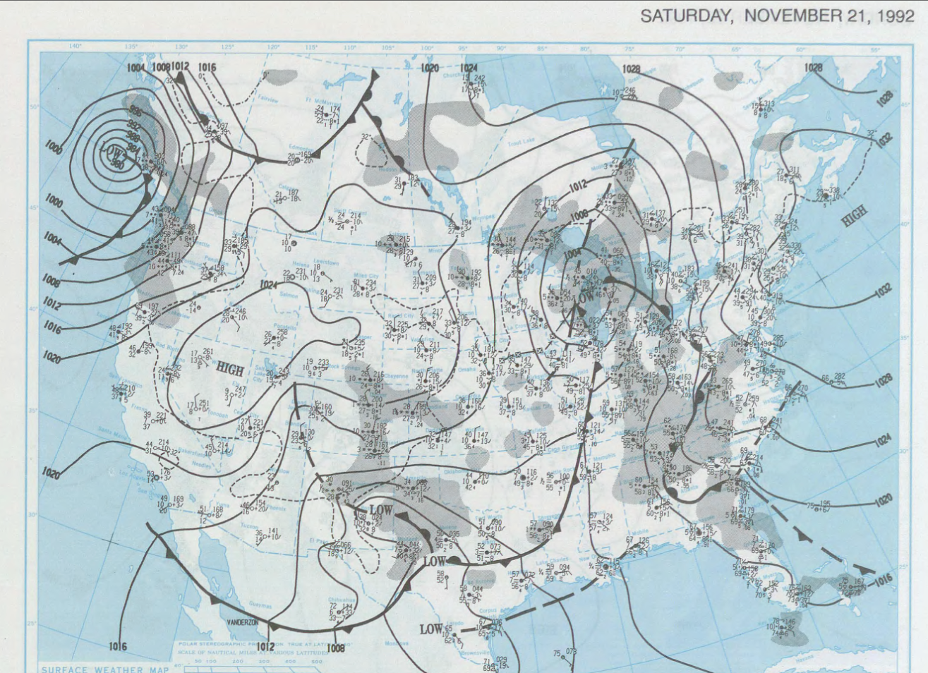
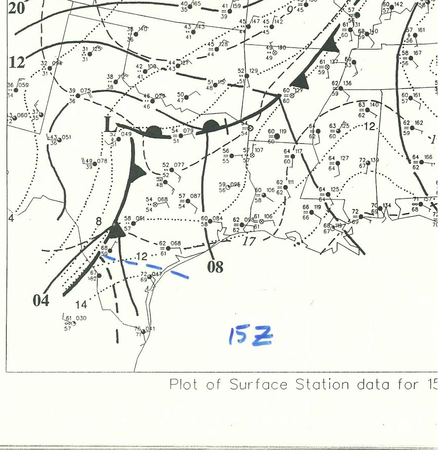
Let’s start with the big picture. From the morning weather map that Saturday, we can see a surface low pressure system in the Great Lakes with a trailing cold front that was stationary over East Texas and connected back west to another surface low in West Texas.
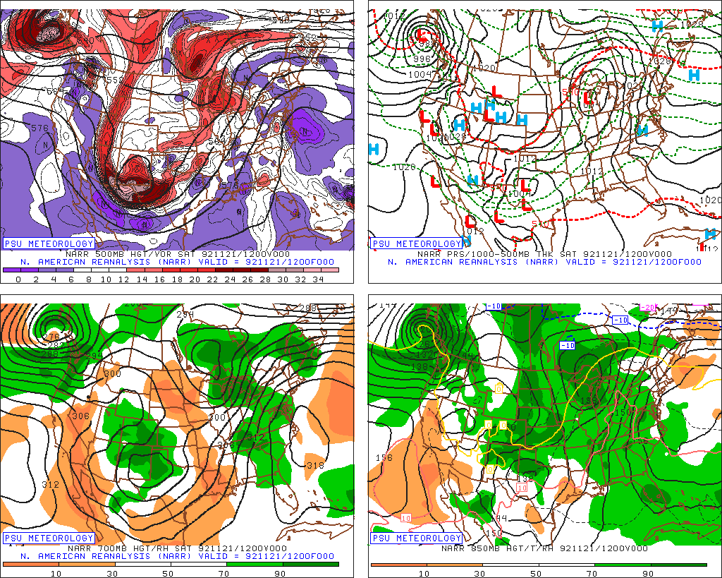
When we look at the reanalysis maps from that morning (shown below), there clearly was a very strong storm system at the 500mb level (about 20,000 feet above us) in West Texas. This was fueling strong southwesterly winds aloft over Southeast Texas that morning.
That Saturday morning started out cloudy, mild, and humid. Temperatures rose in the morning from the 50s into the 60s and the humidity was high. Dewpoints skyrocketed at Hobby Airport from the mid 50s at 7 AM to 70° by 10 AM, indicating a surge in Gulf moisture over the area. This would help fuel severe thunderstorms. Additionally, winds that morning were from the east. This was important. When you look at what we call a “sounding,” or a graph of temperature a dewpoint by height as recorded during weather balloon launches each morning, you see a serious problem.
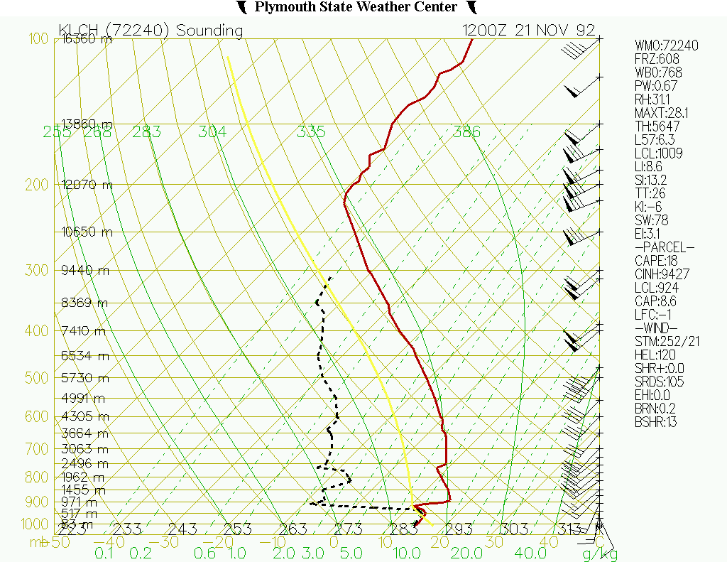
If this plot puzzles you, this link may help translate it a bit. Plotted on the right hand side of the image are wind speeds and the direction they’re coming from as you go up in the atmosphere. Remember, in Houston winds were from the east. Based on the Lake Charles sounding above, winds a few hundred feet up were from the southeast. About 1,500 feet up, they were from the south, 5,000 feet up, they were from the southwest, and about 40,000 feet up, they were from just south of due west. This is textbook strong wind shear.
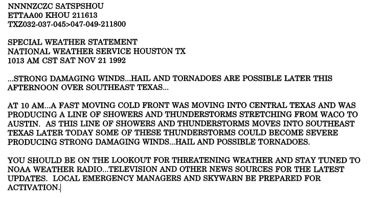
The Houston office of the National Weather Service recognized this danger, and issued a special weather statement that morning highlighting the possibility of tornadoes later in the day:
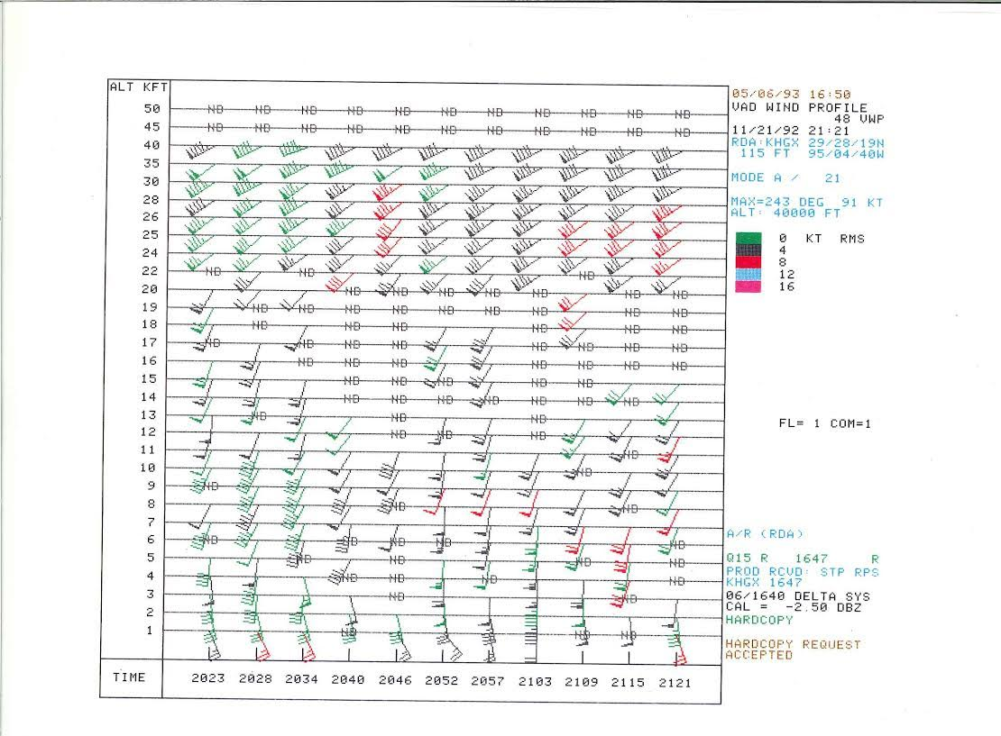
As the forecasters looked deeper into the available data, they saw absolutely incredible wind shear in the Houston area. Additionally, clockwise turning of wind as you go up in the atmosphere indicates that storms can rotate without a lot of effort. As Tim Marshall, a leading storm chaser, engineer, and storm damage expert, also noted, the speed of wind increasing substantially as you go up in the atmosphere (speed shear) helped to sustain the storms and allow the tornadoes to be quite visible. Another look at the wind profile from the Houston radar that afternoon also illustrates this well.
The hodograph that morning from Lake Charles also looked fairly classic for a tornado day.
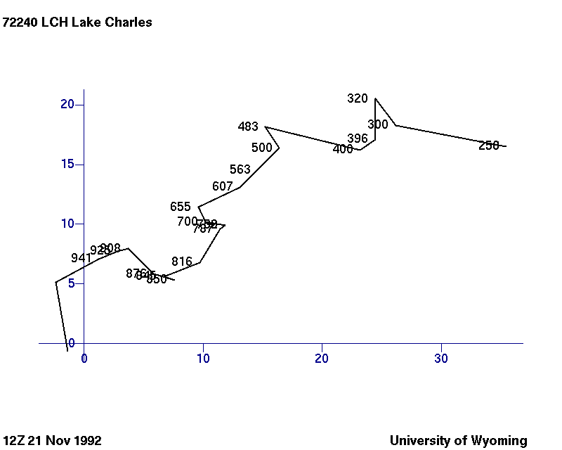
The summary here is simple: Weather maps and parameters that morning screamed tornado potential. By midday, the upper level storm had carved its way into Central Texas, helping to lock in the parameters of the morning and allowing the spark necessary to trigger the tornado producing thunderstorms that afternoon.
(Post continues on next page)
My wife and I will always remember that day! We were married at St. Paul’s UMC on that blustery Saturday. Celebrating our 24th anniversary today.
Happy anniversary! Quite a memorable day for many reasons!
Brings back memories that had been filed away. Yet another reason for reliving these events. Not only for new residents for obvious reasons, but also for longer time residents as well. Certainly not sensationalism, but a gentle poke that things do happen and what we can do to raise our odds of survival.
Though not directly personally affected, I was a public school teacher of a sixth grade campus that served Pecan Grove at the time. The damage to a Randall’s grocery store (Jones Rd and West; now an HEB) was within a mile of the homestead.
Excellent job of reporting. Looking forward to future installments.
Thanks Timothy!
I was just a 13-year-old middle school kid from Sterling Green South in Channelview when this happened (ironically, we were nearer the Kelliwood tornadoes — shopping far from home at West Oaks Mall — when we first learned about what was going on), but I credit the entire experience — and especially helping many of our fellow church members with damaged and destroyed homes in the Sterling Green subdivision — with developing my interest in weather that now makes me appreciate this blog so much.
Thanks for sharing your story (and for the compliments), Justin! Had to be quite an experience.
I am looking forward to future articles in your retrospective series.
In ’92 I was a student at Rice working late in the library on the Saturday before Thanksgiving. I remember it was around 3PM and I looked east from the 3rd floor lounge and saw the blackest sky I have ever seen before or since, moving west. Decided to get out and go home before I might be stuck in thunderstorms.
There wasn’t much weather on my way home, just some rain and wind. However later that day and for the next week the media were full or reports of the local tornadoes that had hit so severely just before the holiday.
PS I remember this also because there was really no forewarning. I was a weather radio fan at the time and recall it was strange that there was no NWS warning for what seemed to be such bad weather coming in. For a few years afterward, local radio and tv went overboard and exaggerated almost any threat of bad weather. That’s how I remember it. Took them years to shake this habit and now we have in my opinion situations in which the media either exaggerate the danger, or overlook it almost completely.
Thanks for sharing your story!
It’s interesting, as the post-storm analysis really commended the NWS for adequate warnings and good lead time (actually, amazingly good for the early 90s). I wonder why that happened. Maybe there was a transmitter issue…will have to go back and see.
I, too, was a Rice student at that time. I remember that we were playing Navy that afternoon, and if Rice won, we would have our first winning football season in who knows how many years. The game was paused in the third quarter while the tornadoes passed by, but it was not cancelled. Morning heat gave way to a wet, cold afternoon. [I learned to recognize that pattern, but at that time I had been living in Houston for about three months.] The field was drenched, as was the audience. Both the MOB and the Navy band moved undercover during the pause, and they played impromptu concerts until the game resumed. The atmosphere at Rice Stadium was festive and unworried.I knew that windows were blown out downtown, but I had no idea of the widespread severity of damage until much later.
Rice did beat Navy that afternoon.
Thanks for sharing with us! Interesting to hear people’s perspectives years later.
Thank you for this well-researched and informative article. Fascinating – and a good reminder not to let our guards down when it comes to severe storms.
I very much appreciate the research and reporting that went into this story & look forward to more retrospectives on Houston’s wild weather.
Thanks so much, Sharon!
I truly enjoyed reading this.
I’ve always remembered the TV images of the planes flipped upside down at the West Houston airport.
That was my gold Jeep Cherokee on the front page. If I am not mistaken that same pic was on USA Today as well.
I ran next door and called 911 at Little Ceasars.
Me and many of my friends were working sacking at Randall’s. It was a extremely busy Thanksgiving shopping day.
Thanks for sharing your story, Chris. Incredible stuff!
That’s me in the middle of the front page. I was working the checkout right in front of the entry. I had just gotten to work and to my register, and I remember the sky was clear on my drive in.
After the store was hit and all the emergency crews got there, I remember they made us all go back into the freezer because another one was forming.
We lived on the corner of South Silver Green and MacClesby when this storm hit. We heard warnings for Wharton and Waller County, but that seemed so far away. I remember looking out the window and wondering what all the fuss was about because it was barely sprinkling and no wind. Then I saw a small dark wispy cloud (like a puff of smoke) just over the rooftops, moving really fast. I called my husband to the window so he could see the strange cloud and as soon as he got to the window, we saw the transformers blowing up behind us in Sterling Green South. That’s when we saw the tornado – we raised the living room window where we stood, grabbed the 2 dogs and made it almost to the hall before the windows started blowing out. Our garage was ripped off the house, nothing left but a pile of bricks and the roof was lifted and set back down crooked. Our washer and dryer ended up in the middle of the street and someone’s mattress was tangled in our tree. Our neighbor had a 2×4 stuck in the engine of his truck and we found clothes that didn’t belong to us in the living room. We couldn’t eat much for 2 days because our throats were so swollen from all the insulation we breathed. The Salvation Army served breakfast in our backyard for a couple days afterwards and the news stations set-up next to the house. Until I read this article, I didn’t realize we were dead-center of the path. Gave me chills, remembering. To this day I still don’t understand why it wasn’t raining or the wind wasn’t blowing – it was just an overcast afternoon.
Thanks for sharing your story. I was wondering if we’d hear some first-hand accounts from readers on this eventually. Really incredible. I’m glad you were able to escape without being too seriously hurt.
Small world. Remembering this on the 25th anniversary. I happened to be at a friend’s house in the 1400 block of Macclesby when the tornado hit. We lived around the corner on Rockington Ln. Was a crazy experience. I remember running home after in the rain to check on my parents and sister. Luckily, they hid in the restroom and survived. The house, not so much. The tornado took the whole roof off the house and the garage caved in. Never forget that day.