I’ll get to the forecast for Christmas week and weekend in a minute, but first I wanted to put some of this month’s temperatures into perspective.
DECEMBER
Houston has had a warm December, but how warm? The answer is not that much warmer than normal. So far this month has had an average temperature of 58.0 degrees, and that’s going to probably end up a few degrees higher by the end of this week given what’s ahead.
Nevertheless, as the chart below shows, even an average temperature of 60 degrees would remain well beneath the all-time record for December (set way back in 1889), and it’s far from a certainty that this December will even finish within the city of Houston’s top 10 warmest Decembers.
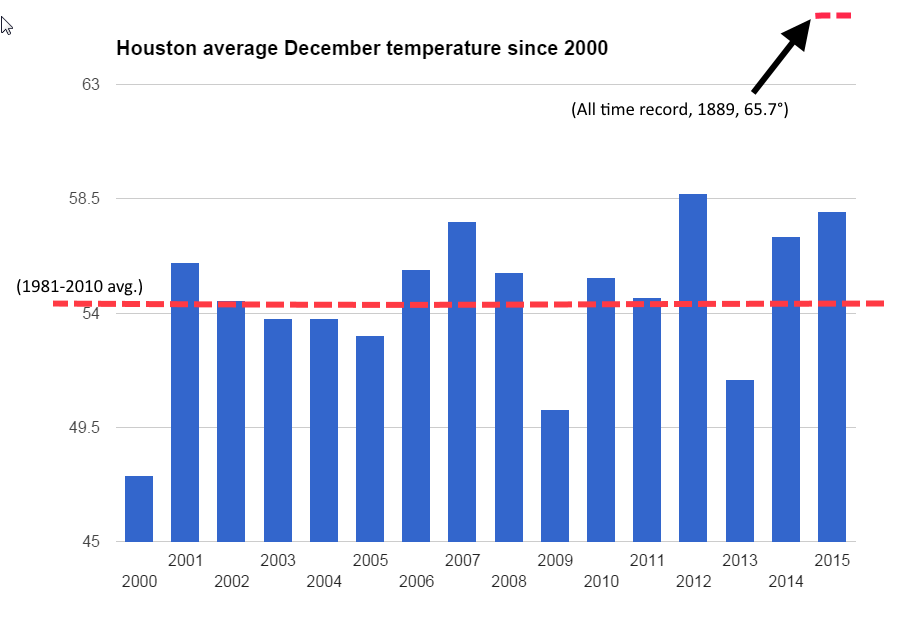
So while it has felt warm this month, and very likely this December will end up being the warmest since at least 2000, we’re not seeing historically warm weather.
But what about Christmas Day itself? Here’s a look at the five warmest Christmases on record in Houston:
1964: 82°
1955: 79°
1942: 79°
1987: 78°
1934: 78°
How close will we come to the top five? Read on below for the forecast.
TODAY
It’s not at all cool this morning, with low temperatures in the upper 60s. This is a normal low for Houston in mid- or late-September. The increased humidity levels and clouds will set the stage for a warm day with highs in the mid-70s and scattered rain showers.
TUESDAY
Storms — possibly severe thunderstorms — will be possible on Tuesday afternoon and evening as an upper level disturbance moves into the area. The main threat appears to be for inland areas, as shown in the map from the Storm Prediction Center below. I’m not anticipating any kind of flooding threat.

Temperatures will remain unseasonably warm.
WEDNESDAY-THURSDAY
Showers should end late Tuesday, and Wednesday and Thursday should see unseasonably high temperatures near 80 degrees, with lows in the low- to mid-60s. Skies should be partly sunny, with only a slight chance of rain later on Thursday. Great weather — if Santa’s bringing you a new swimming pool for Christmas.
CHRISTMAS DAY
Christmas will start off mostly cloudy, with temperatures in the mid- to upper-60s. Highs will rise into the upper 70s to maybe 80 degrees. As if that weren’t enough, there will be a pretty good chance of scattered showers throughout the day as moisture levels increase across the area. So warm, and quite possibly wet. Good weather for … I’m not sure.
WEEKEND
Next weekend seems likely to bring the same, warm, humid and on-and-off rainy conditions before a cold front finally moves through on Monday.
Will it be a cold front or a cool front next Monday?
Actually, NO complaints here! I’ll take the “warm” weather vs COLD or Houston HOT any day!! Now, if the sun were shining, this would be most perfect!! 🙂
80 degrees during Christmas is gross.
Guess it could be worse, it could be 90°. . .
Eric, how does this winter look?
The private service we use at work is calling for colder and wetter than normal. But their confidence in that didn’t look too high.