In brief: Severe thunderstorms are developing in Houston as of noon on Friday, and will pose a threat for the next 12 hours across the region. We’ve got details about all of the threats in this update, with a particular concern for the evening commute.
As anticipated, with daytime heating, we are seeing severe thunderstorms developing in the Houston region. As of 12:30 pm CT there are large clusters of storms near Kingwood and just west of Katy. From this point forward we expect additional development throughout the afternoon and evening hours as the capping inversion over the region breaks.
From now until about 5 pm the majority of activity should be clustered along and north of Interstate 10, but that certainly does not preclude thunderstorms developing in the southern half of the region. Unfortunately we expect that the majority of the region is likely to see activity during the evening commute as the storms spread, making for a messy time on freeways. If you can leave earlier today, that’s probably for the best.
In terms of threats we have three major concerns right now.
RAIN: These storms will be capable of producing heavy rainfall, and under high rainfall rates we are likely to see street flooding. For this reason we have implemented a Stage 1 flood alert for the region through tonight. Essentially, you need to be weather aware on roads, take extra time, and do not drive into high water. Rainfall amounts will vary widely, with most of the area likely picking up 0.5 to 2 inches. I am concerned about a few bullseyes of 4 inches or more, which are possible.
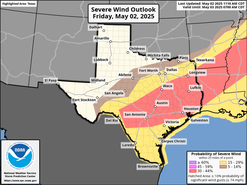
Severe wind outlook for Friday and Friday night. (NOAA)
WIND: There is a healthy chance of damaging winds with these storms, so anything you can batten down would be helpful. The threat of damaging winds is the highest we have seen so far this spring, so again this is another reason to stay off roads amid strong thunderstorms this afternoon and evening if possible.
HAIL: In some thunderstorms near Kingwood weather spotters have already observed quarter-sized hail this afternoon. So this is a distinct threat as well as these storms pass through.
Tornadoes are also possible, but the threat is on the lower end of the scale.
Over the next several hours the bulk of the storms will shift southward, ahead of a front rumbling into the area. Areas south of Interstate 10, accordingly, will likely face the greatest threat of severe weather from late this afternoon to late this evening. By midnight, or shortly afterward, the threat of storms should move offshore. After that, the weekend looks lovely.
In brief: Strong to severe thunderstorms are likely this afternoon and evening in the Houston area, especially north of I-10. Hail and strong wind gusts are the main concerns. Heavy rain is also likely in spots, so a stage 1 flood alert has been posted. After today, we get some quiet, if not absolutely beautiful weather this weekend.
Today/tonight
So, let’s get this out of the way first: This morning looks fine. No issues.
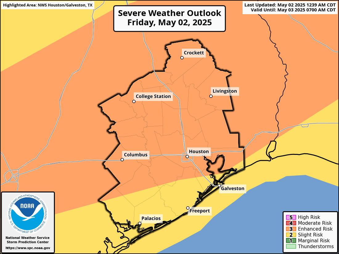
Starting this afternoon, probably not long after lunchtime, numerous showers and thunderstorms are likely to begin developing north of I-10. The environment over Houston looks conducive for virtually any storm to become strong to severe today. As such, we are now in an enhanced risk (3/5) of severe weather this afternoon and evening.
An enhanced risk (3/5) is posted for severe weather today. (NOAA SPC)
The two main threats today will be pockets of strong wind gusts in excess of 40-50 mph and the potential for hail. An isolated tornado cannot be entirely ruled out, but the bigger risks are damaging wind and hail today. The evolution of storms today will probably be individual cells eventually congealing into a line that lingers for a bit over much of the Houston area, again focused near or north of I-10. The severe storm threat should begin to wane after sunset, but additional thunderstorms are likely, especially south of I-10 overnight. So, almost everyone should get a chance to participate today with the nastier storms north this afternoon and evening and less intense storms south this evening and overnight.
In addition to the hail and wind, these storms could produce torrential rainfall, with totals of up to 3 or 4 inches possible in isolated pockets. Street flooding could easily crop up with storms like this. So, with that in mind, we are issuing a stage 1 flood alert for this afternoon and evening across the area, mainly north of I-10.
There are always fail modes on days like this, and it could be that we end up with heavy rain and generic thunderstorms more so than severe weather. But the environment today is definitely primed for some strong to severe storms, so particularly between about 1 PM and 8 PM, you’ll want to remain tuned into what’s happening.
Eric will have the latest for you around midday with a fresh update. We will follow with further updates as needed thereafter.
Saturday and Sunday
After some lingering showers well south of Houston or near the coast in the morning, Saturday itself looks like a fine day. Actually, it may end up being an absolutely spectacular day, but I want to keep expectations a little in check. But expect a return of some sunshine, noticeably lower humidity, and highs into the low 80s. Morning lows should be in the lower 60s. Look for much the same on Sunday without the morning shower chance.
You never know when you’re going to get your last really, really nice day before summer sinks in, so take advantage of tomorrow and Sunday if you’re able!
Next week
After another decent day Monday (albeit a bit warmer), we will re-emerge into an unsettled weather pattern for much of next week. Day by day details are tough to pin down right now, but look for at least a chance of thunderstorms on Tuesday, Wednesday, and Thursday. Some of the storms could be strong, and some of the rain could be heavy.
More data!
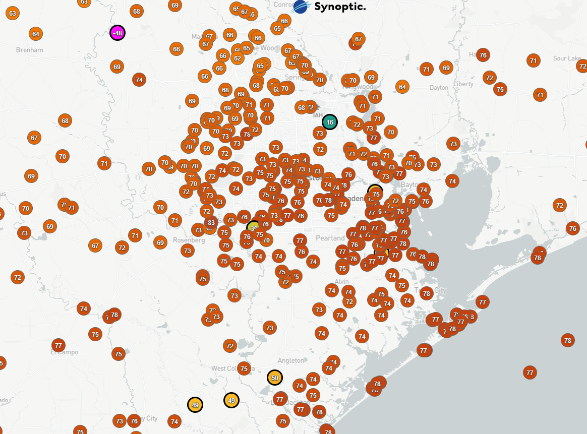
I generally abide by a separation of church and state when it comes to my day job and my work with Space City Weather. However, I am going to make a minor exception in this case. For those that do not know, I was hired in November to be CenterPoint Energy’s new manager of meteorology. Among the many things I was tasked with out of the gate was siting and launching a network of 100 weather sensors across the Houston area, as part of the company’s commitments in the Greater Houston Resiliency Initiative. In case you had not seen earlier this week, that process is now underway, and you can see the data from over 60 new weather sensors across the area here!
A map of just CenterPoint’s new weather sensors (Synoptic)
You may ask, “Well aren’t there already a lot of weather sensors reporting here?” The answer is yes. There are. But even when you plot virtually every network of weather stations, there are still some data gaps, there are periodically reliability issues, and most of you know how the weather goes in Houston where it rains at your neighbor’s house but not yours.
A map of all the weather sensors from all networks across the Houston area. (Synoptic)
I’m hoping we can fill some of those gaps, assist with improving weather forecasting in the Houston area, and add additional data to be used by the NWS, flood control agencies, etc. to assist in understanding or researching weather in the Houston area. More data is good for everyone. So this project has excited me, I’m glad we can share this data with the weather community, and I look forward to seeing it grow further.
In brief: Today’s post reviews an unseasonably warm April and then looks ahead to some dynamic weather on Friday. Much of the region should see storms between Friday afternoon and Saturday morning as a slow-moving cool front moves into the region. After this, the weekend looks quite nice for early May.
May arrives
If April seemed rather warm, you’re not wrong. The month ended last night, and for the greater Houston region it was a seasonably sizzling one. The city’s average temperature was 74.6 degrees, which is nearly 5 degrees above normal. This ranks as the fourth warmest April of all time in the city’s history. One reason is that the city saw no real fronts during the second half of the month. But that does not mean summer has quite yet arrived in Houston. A modest front will reach the city this weekend, and another one is possible about 10 days from now. These won’t be strong fronts, as such things are rather rare for May. But any dry air this late into the spring season is welcome.
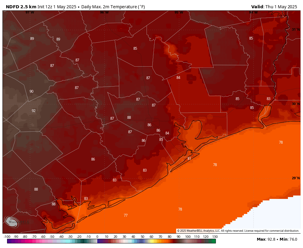
The first day of May will be a rather warm one for Houston. (Weather Bell)
Thursday
If you’re wondering about those storms on Wednesday night, they essentially remained north of Highway 105, with only a smattering of rain making it down into the Houston metro area. Plenty of moisture remains in the atmosphere so we may see a few showers and thunderstorms today in Houston, but I expect most of us to stay dry. As skies clear out this afternoon, it should be rather warm day, with a few inland locations probably reaching 90 degrees this afternoon. Winds will be from the south at 10 mph, gusting perhaps to 20 mph. Lows tonight only fall into the low 70s for most locations.
Friday and Friday night
In terms of temperatures and humidity, I expect Friday to be similar to Thursday, however I do expect to see less sunshine. The big thing to watch is the possibility (likelihood, really) of showers and thunderstorms on Friday afternoon, evening, and overnight. As a front approaches Houston we are likely to see a mass of showers and thunderstorms develop north of Interstate 10 by Friday afternoon or early evening, and we cannot rule out some hail or damaging winds with these. Although I believe the formation of tornadoes is unlikely, I cannot say none will occur.
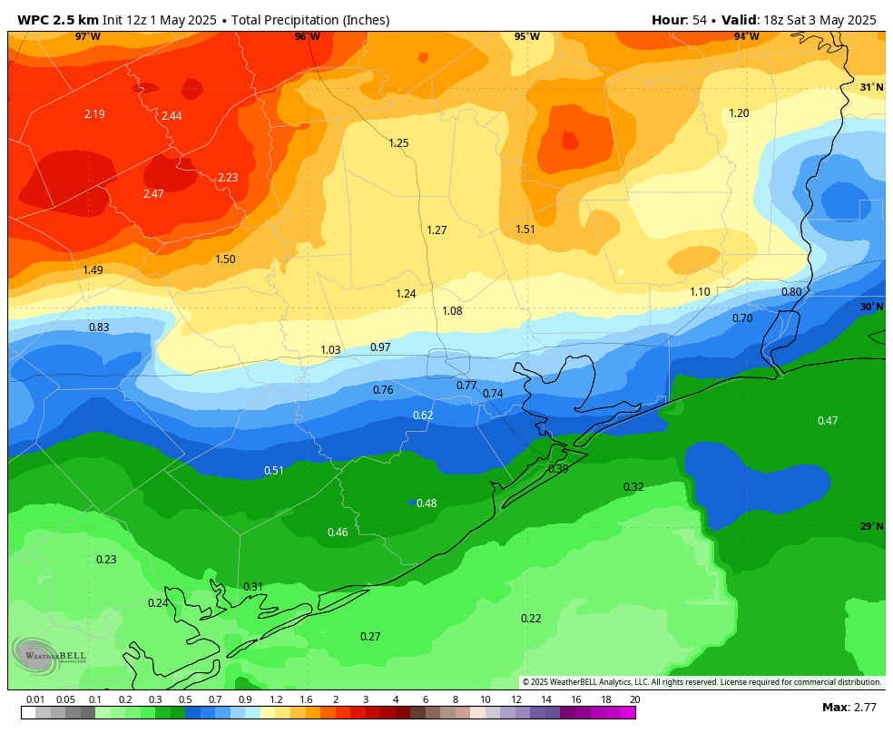
Later on Friday evening, or perhaps around midnight, these storms should march southward toward the coast before the whole thing moves offshore some time on Saturday morning. Because we are still nearly 48 hours from all of this, we are just coming into the range of high resolution modeling. However I want people to be aware that the region could see 0.5 to 2 inches of rain on Friday evening and night, with the possibility of thunderstorms. If you have plans for Friday night, this is definitely something to take into account.
NOAA rain accumulation forecast for now through Saturday morning. (Weather Bell)
Saturday
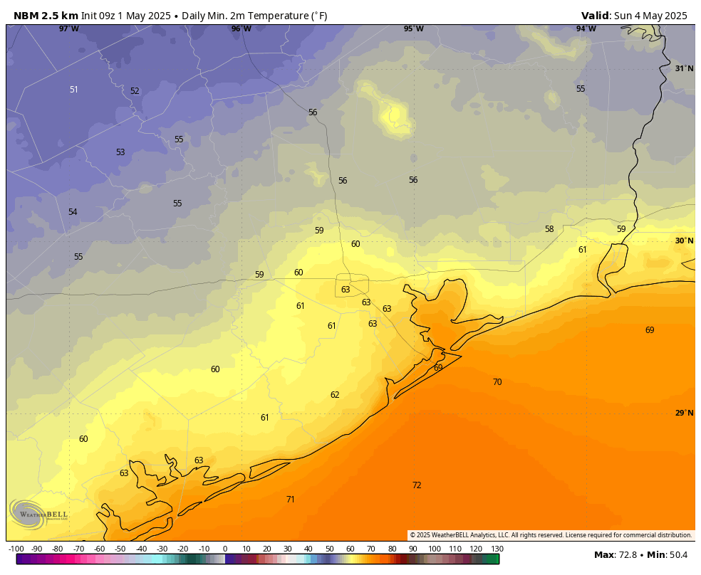
Rain chances will likely end on Saturday morning, and we should see some clearing skies during the afternoon hours. High temperatures will likely reach about 80 degrees for most locations, with some modestly drier air. Lows on Saturday night will depend on how far you live from the coast, with areas south of I-10 maybe reaching 65 or the lower 60s, whereas some areas further inland have a chance to reach the upper 50s. It should, in any case, feel pretty nice.
A reasonable guess at low temperatures for Sunday morning in Houston. (Weather Bell)
Sunday
Dare I say this may be the nicest day the region sees until some time in October? Expect mostly sunny skies with a high temperature in the vicinity of 80 degrees. With dewpoints in the 50s, the air will feel reasonably dry. Although we cannot entirely rule out a few isolated showers at this point, I don’t expect much rain. Lows on Sunday night will, again, drop into the lower 60s for most.
Next week
Already on Sunday we’ll start to see the return of a southerly flow, and this will eventually nudge temperatures and humidity back up next week. The bigger story will be a lumbering low pressure system that is likely to be a rainmaker for the region. It’s hard to predict totals, but next Tuesday, Wednesday, and Thursday look to be fairly soggy ahead of possibly another weak front.
It’s another just-in-the-nick-of-time edition of the Space City Weather Q&A. If only we could get a few more days added to each month, maybe we’d get this out the door sooner. Or maybe April’s edition would just end up publishing on April 33. Who knows?
Anyway, let’s get to it. As always, if you have a question for next month, drop it in the comments below or hit the Contact link on the blog home page.
Q. I’ve been noticing over the last few months. The last couple of major storms that were supposed to be severe, once they came thru Harris County were unable to break the cap. What is causing that to happen? Is this common in La Niña springs?
A. Welcome to weather forecasting, my friend. The reality is there are a lot of variables needed for storms to develop, and sometimes they’re very difficult to forecast.
You mentioned La Niña, a cooling of the tropical sea surface temperatures of the Pacific Ocean. It’s not entirely clear to me whether we’ve been in a very weak La Niña or neutral conditions since about February, so I really don’t think that’s a factor. We also have seen some pretty decent thunderstorms this spring, it’s just that all have not hit. The reality is that sometimes storms make it, and sometimes, whether it’s a lack of instability or other factor, they don’t.
I would also add that spring storm season is not over. It typically lasts through much of May before we get into a pattern more dominated by high pressure in June. If you’ll recall, the destructive derecho that hit Houston last year did so on May 16. So, like, knock on wood or something. –
–Eric
Q. A reader visiting Hamburg, NY, reached out to ask: We visited Woodlawn State Park, on Lake Erie. The “beach” had frozen iceberg formations (which was still cool to a Texas girl). Not really an iceberg, they were small frozen disc situations. But the interesting part was: the ‘iceberg’, when you ran you finger across the side: ice crystals or icicles easily poured off the side of it. So the “icedisc” (or iceberg for dramatic effect) was actually made of these ice crystals. What was going on there?
A. As the resident Upstate New York veteran, I will say that what you probably witnessed was a phenomenon known as “pancake ice!” My tell is that you said you ran your finger across it and ice poured off the side. Pancake ice usually has raised edges, so that seems to check out. Sweet as it may sound, pancake ice forms in an interesting way.
Lake Erie is the shallowest Great Lake, so it tends to freeze over in wintertime. It starts with a slushy, thin ice that forms initially. Over time, that slushy, greasy ice will thicken up and becomes what is known as nilas ice. This is where you start to see an ice sheet develop. If it gets cold enough, long enough, and the ice thickens more than 4 inches, that becomes known as “first-year ice.” It always warms up enough to melt Lake Erie’s ice, so as that process begins and we start to see more of a transition season occur, with warm spells peppered by cold blasts, that’s when some fun ice formations can occur.
In the case of pancake ice, you get some of that thinner ice that crashes into other thinner ice and forms disc-like shapes in rough water. Basically, the wave action smooshes some of the thinner ice together into discs. Those discs can hit other discs and you get a saucer shape with raised edges. Hence, pancake ice.
The Great Lakes are a fascinating place. Between some of the ice features, lake effect snow, lake breezes, and more, it’s a fun place to practice meteorology.
–Matt
Q. Every spring there’s this period of a couple weeks (maybe more?) when everyone’s car is covered with yellow pollen. I have two questions about this: Is the week when this starts predictable each year, like “third week in March is pollen week”? And is how long it lasts predictable, as in “when will I be able to wash my car”? Or are we at the mercy of the pollen gods every year?
A. There is essentially pollen all year long in Houston, but you’re referring to tree pollen and most particularly pollen from oak trees that cake anything left outdoors in yellow and green. There is no set period for this because when it occurs depends on the weather. A longer and colder winter will delay pollen season, and a shorter and warmer weather will cause trees to bloom earlier. Typically tree pollen season peaks during March or the first half of April, but not always.
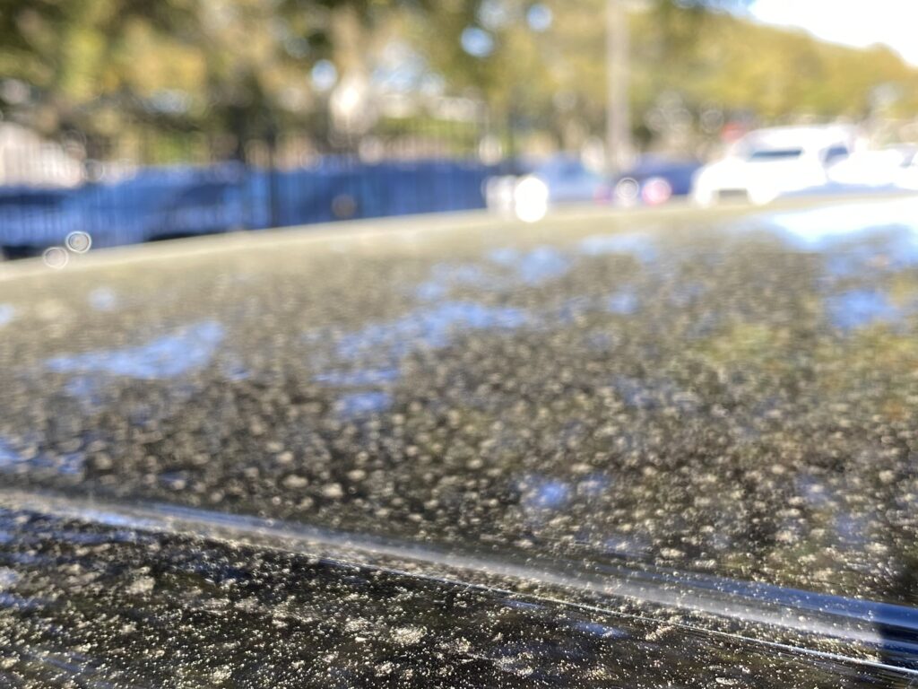
Pollen coating cars is a sure sign of spring in Houston. Also: Achoo! (Dwight Silverman photo)
The height of oak pollen season lasts about two or three weeks, but again this duration depends on the weather. Windy conditions and heavy rain can bring more pollen down sooner, whereas mild conditions can extend the time. But the good news is that once oak pollen season is over, it’s over. And we’re left with these amazing, leafy old trees that provide shade during the long and hot summer months. I consider it a fair trade. If you’re interested in data, the city of Houston has a good website that tracks all manner of pollen in the air, on a daily basis.
–Eric
Q. I have several weather apps on my phone, and I’m kind of a weather nerd so I am always looking at others. I have the Space City Weather app, obviously, but I’m curious: Other than that one, what is is Matt’s andEric’s favorite app and why?
My favorite free weather app that I can recommend to people without hesitation is an app called Everything Weather, by Cory Mottice, for both iOS and Android. Why do I like this app? No ads for one thing. Secondly, it’s almost entirely National Weather Service data, and immediately you are presented with any hazards for your location.
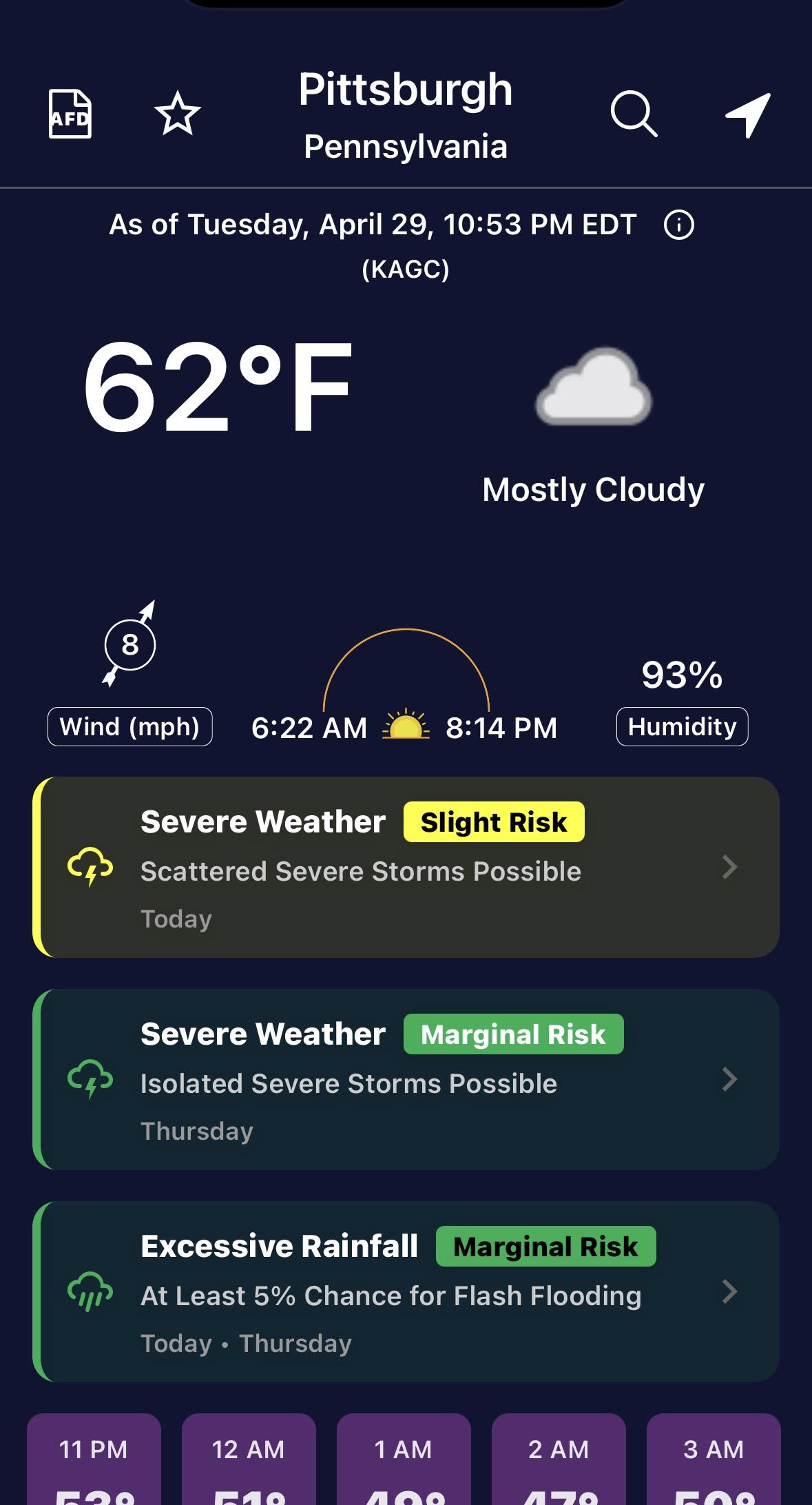
Screenshot of “Everything Weather” forecast screen. (EverythingWx)
You can see above that for Pittsburgh there is a slight risk of severe weather on this day, a marginal risk Thursday, as well as a marginal risk of excessive rainfall. You can scroll down and tap whatever day you want for a brief description of the forecast.
Scroll to the bottom and find your local NWS office’s “weather story,” which adds critical context to a daily forecast, particularly when bad weather threatens. You can also tap “AFD” at the upper left and instantly read the NWS’s technical forecast discussion for that area.
Basically, it accomplishes the rare feat of giving a ton of information to both average consumers and more sophisticated weather nerds in one app on one screen. It also has radar functionality, though no dubious rain alerts that are very hit and miss in other apps. You can also customize what threshold you want for NWS alerts, or you can say I want “Open Meteo” weather data instead of NWS.
One drawback? No push alerts that I am aware of. So if you want immediate notification of weather warnings, you’ll need to shop around.
–Matt
My favorite app is Spotify. When I was growing up I had an allowance of $10 a week and a summer job detasseling corn that paid a pittance. Between regular trips to the CD store and Columbia House, I was able to cobble together a music collection. Sometimes, when money was tight, I would resort to taping new releases played on the radio with a cassette tape. It now seems pretty magical to be able to listen to any song I want to, at any given moment, from across the history of recorded music.
Oh, wait. You meant weather app.
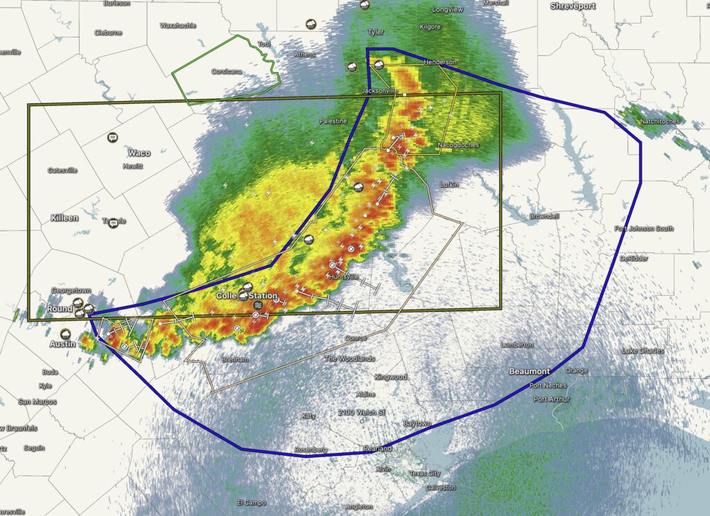
RadarScope is about as good as it gets when comes to showing storm information.
As always, I think RadarScope is the best weather app because it provides essential radar information during inclement storms. Never leave home without it!
–Eric
Nobody asked me, but I’ll second Eric’s RadarScope endorsement, and add that it’s available for almost every platform. For Apple users, it works on iPhones, iPads, Macs, Watch and even the Apple TV streaming box. The paid features (two tiers) give you lots of details, such as storm track and lightning strikes, and if you pay once for the Apple version, the pro features are available on all those devices. It’s also available for Android and Windows, though you must pay separately for each of those.