In brief: Drought continues to expand in Texas, and pollen levels are roofing in Houston with warm, dry weather. There are some rain and storm chances for Sunday night or early Monday and again next week, but those are far from certain. Warmer weather returns and lingers.
We got the drought map update yesterday for the country, and as you can see below, drought is expanding in Texas. While the majority of the Houston area is not there yet officially, it doesn’t take much to tell we need some rain around these parts.
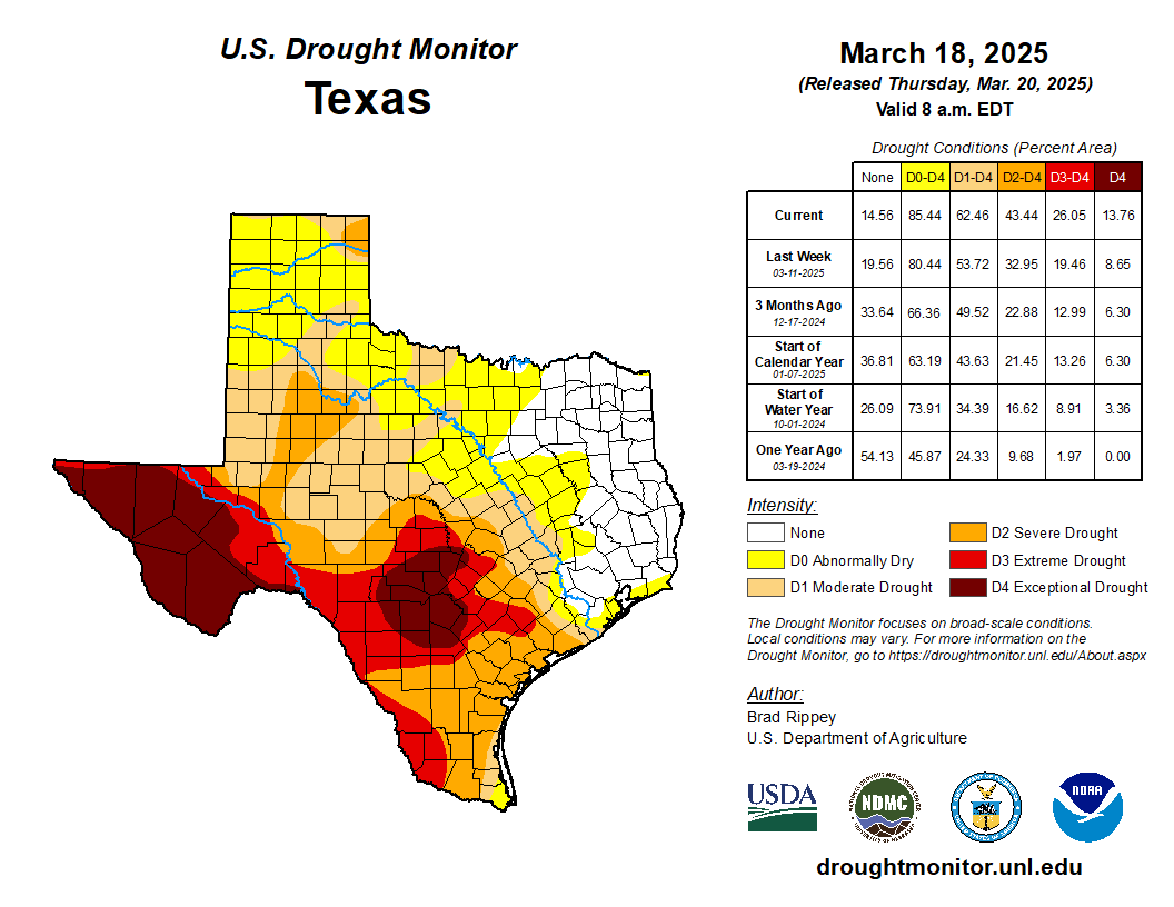
While West Texas and Hill Country are in exceptionally bad drought, we’ve got problems of our own locally, as evidenced by the Pauline Road Fire north of Houston on Wednesday and Thursday. This fire was apparently started as a result of a prescribed burn, and it expanded rapidly due to 20 to 30 mph winds and low humidity, along with increasingly dry ground. The type of fire conditions in Texas that are currently in place have not really been seen since 2011. So, again, we need rain.
The pollen, as Eric noted yesterday is another matter. Our tree pollen count in Houston hit over 9,000 yesterday for the first time since the brutal April of 2022, when we exceeded 12,000 on April 7th. Yesterday, should it be our peak pollen day, will be right around average but the second highest since 2017.
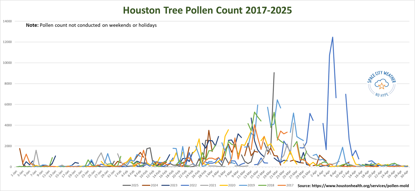
You can see the large jump yesterday in 2025’s data on the chart above. Historically, Houston’s tree pollen will have a handful of big days, then slowly tail off. Notice how 2022, while the worst in the data set also peaked quite late. If history is a guide, the oak pollen levels mostly responsible for this data spike should slowly (emphasis on slowly) subside in the next few weeks. But suffice to say, it will be bad at times over the next couple weeks for those with seasonal allergies. That especially holds true if we don’t get any rain this weekend.
Today and tomorrow
Winds will turn around eventually today and start coming out of the south. This will raise our humidity levels and keep us outside of red flag conditions. After a very cool start this morning, we will warm into the 70s this afternoon. A picture-perfect day.

If you’re headed to the final Friday of the Houston Livestock Show & Rodeo to get a listen to Parker McCollum tonight, expect clear skies with a slight breeze on the way in. Temperatures should be around 70 degrees, slipping back into the mid-60s by the time you head back home.
Overnight lows will be about 10 degrees warmer tonight than they were this morning. That warmer start will allow Saturday to pop into the 80s. Look for a mix of sun and clouds with no weather woes.
Sunday
Most of Sunday will be fine. Expect clouds and some sun, along with warm weather. Highs should get into middle 80s on Sunday afternoon. As a disturbance drops southward during the day, we could see one or two thunderstorms pop up across the area very late Sunday afternoon, probably after 3 or 4 PM. Any of those storms could be on the stronger side.
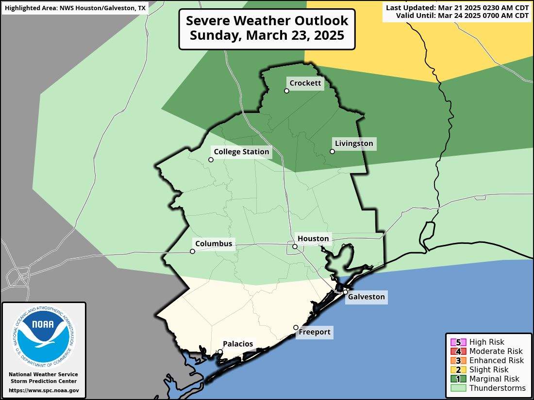
That said, we are not currently in a severe weather risk highlight, just a “general thunderstorm” area. However, this is the type of setup where if one storm can find the right environment it could make some noise. In other words: We’re probably fine on Sunday, but there could be a storm that gets a little noisy.
There could be some strong to severe storms well north of the Houston area that form into a weakening line of thunderstorms Sunday night, arriving in the Houston or perhaps Beaumont areas late Sunday night or early Monday morning. There should not be severe weather along this front, but some lightning, heavy rain, and gusty winds are possible as this moves into the area.
Monday
Any showers or storms should push offshore Monday morning, and we’ll be left with gradual clearing. Expect highs to jump back into the upper-70s or low-80s.
Rest of next week
Tuesday looks quiet right now. Wednesday may see another chance at some showers or thunderstorms, but it’s a bit soon to offer up more than just a low chance. We could see more widespread rain chances by Thursday.
In terms of additional fire weather, humidity levels look to stay high enough to avoid much more serious concerns next week. But the rain we see (or don’t see) may play a role in ultimately determining that. Monday or Tuesday will probably have the lowest humidity for the week. Temperatures will likely be a bit above 80 degrees, with morning lows in the 60s.