In brief: Today will again see scattered rainfall across the metro area before more widespread showers and storms push into our region beginning tomorrow. The period of Thursday through next Tuesday should see daily rain chances above 50 percent, so make any Labor Day plans in Houston and Galveston with a backup indoor option.
Wednesday
Today is probably the final day with only “scattered” showers and thunderstorms rather than more widespread storms. Locations south of Interstate 10 probably have about a 50 percent chance of rain today, with lesser chances inland. Skies will, accordingly, be partly sunny and high temperatures for most regions are likely to reach the lower 90s. This probably will be our hottest day for the next week. Low temperatures will drop into the upper 70s on Wednesday night.
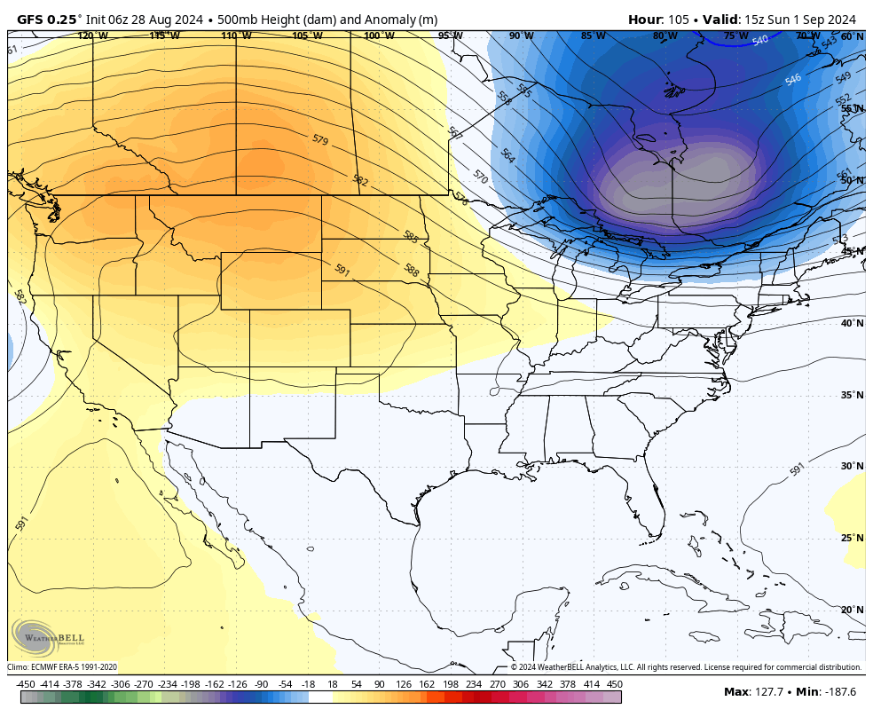
Atmospheric “heights” this weekend indicate that the Texas coast will be wide open to Gulf moisture, thanks to the absence of high pressure. (Weather Bell)
Thursday and Friday
Rain chances will be higher to end the work week, likely in the vicinity of 70 or 80 percent for most locations. I expect these to be mostly passing showers, so accumulations during each storm will likely be one-half inch of rain, or less. With partly to mostly cloudy skies, most locations should see high temperatures in the upper 80s to around 90 degrees.
Labor Day weekend
Unfortunately, if you were hoping to end summer with a beach bash over Labor Day weekend, you’re likely to be disappointed. The combination of plenty of moisture from the Gulf of Mexico and a couple of upper-level low pressure systems will keep the threat of daily rainfall high, especially for locations closer to the coast. Daily rain chances over the holiday weekend will be in the 60 to 80 percent range. These showers won’t last all day, to be sure, but they’re likely to put a damper on outdoor activities. Highs will range from the upper 80s to about 90 degrees for most locations.
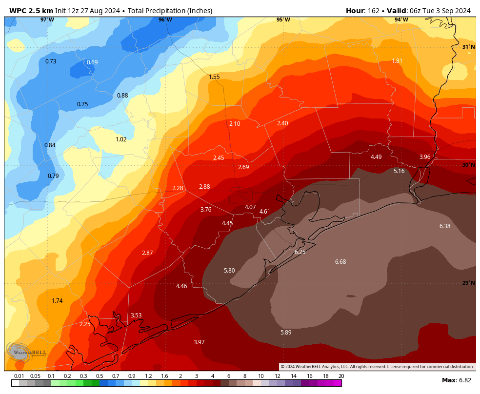
NOAA rain accumulation forecast for now through Labor Day weekend. This is just an estimate, remember. (Weather Bell)
Next week
Conditions on Monday and Tuesday of next week may become even more favorable for showers, and the potential for heavy rainfall. We’re not ready to call for a Stage 1 flood alert for coastal areas, as I want to see more data. But the potential is there. Regardless, the threat of moderate to heavy rainfall will persist for the entire region, along with highs in the upper 80s to 90 degrees.
By Wednesday or so, the potential for widespread showers starts to diminish, and the latter half of next weekend probably will start to see more sunshine and less rainfall. Highs probably will get back into the low-90s.
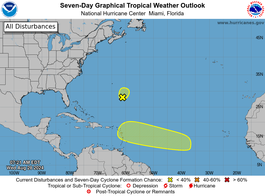
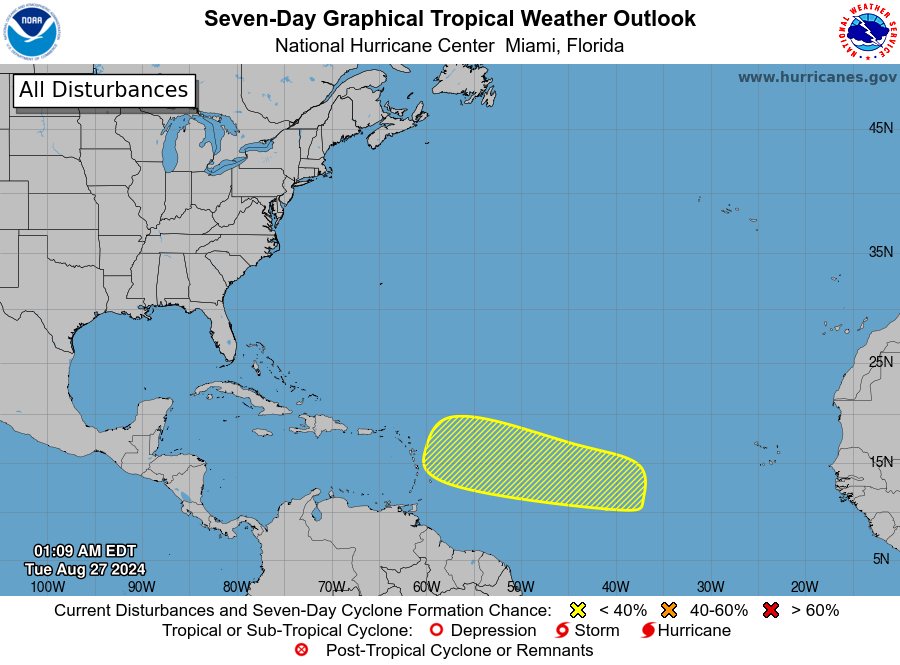
Seven-day outlook for the tropics. (National Hurricane Center)
Tropics
The National Hurricane Center is continuing to track a couple of areas that have a low-end chance of developing, but in terms of the Gulf of Mexico there is not a whole lot that gives me pause about the next week or so.
Man, will you look at the calendar! August’s almost done with us, but we are not done with it, which means it’s time for our monthly Space City Weather Q&A.
And yeah, we know, there wasn’t an installment in July. We have no excuses, other than to say that July was . . . a little busy.
Anyway, we’re reporting for duty now. On with your questions!
And don’t forget to to feed this beast: Post questions for future Q&A’s in the comments here, or use the Contact link below the blog’s header.
Q. If you were on summer vacation, at what time would you come back if there was something tropical-ish heading for Houston?
A. First, a word on my own plans for summer vacation. I try to never take them in August or September, because that’s the time I’m most concerned about when it comes to tropical weather and Houston. And when I travel in June or July, I definitely bring a laptop.
As for returning in the face of tropical weather, it’s really a difficult question because there are so many variables. Are you returning to prepare your house, only to evacuate again? Are you returning to prepare and hunker down? Are you most concerned about, wind, surge, or inland rainfall? That said, the fundamental question I would want to answer is how long you need to make whatever preparations you want to make before the storm hits. If it is 24 hours, then I would return no fewer than 24 hours before the onset of tropical conditions.
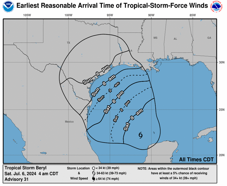
The National Hurricane Center has a useful tool for this you can use during active systems. This product offers a forecast for “earliest reasonable arrival” of tropical storm force winds. (The image below shows the forecast for Beryl, issued on the morning of Saturday July 6, for example). Essentially, this is a good guide to when final preparations for an impending storm should be made. We sometimes publish them on Space City Weather for this very purpose.
–Eric
Example of “earliest reasonable arrival time” of tropical storm winds during Beryl. (National Hurricaen Center)
Q. On Sunday, July 21, in a special weather statement for areas east of Houston, the statement talked about the risk of tropical funnel clouds. What are these and why is there a special weather statement for them vs. a tornado watch?
A. This is a good question. It’s a phenomenon we see frequently in Southeast Texas but not one we really talk a lot about. Tropical funnel clouds form typically when it’s humid and breezy. Why do they form? Funnel clouds form by similar processes both within supercell thunderstorms (which can produce tornadoes) and in these more benign tropical environments. With breezy, humid conditions, you can get a setup with a little bit of wind shear, especially near the coast, where wind direction may change with height. This can lead to some “spin” in the atmosphere, or what we call vorticity. As that vorticity gets stretched out a bit vertically, you get faster spin. And as that happens, you can get a funnel cloud.
So why are these benign? The process by which these funnel clouds form is much slower than the process by which supercell thunderstorms can produce funnel clouds and subsequently tornadoes. Additionally, they usually dissipate after a few minutes. Very few of these funnel clouds ever reach the ground, producing a tornado, and even if they were to do so, the tornado would likely cause minimal, minor damage. So they’re more likely to just get noted as a curiosity more than anything else. Because the process is slow to evolve and quick to dissipate, it doesn’t warrant a watch or warning.
–Matt
Q. My mom says she can remember back 10 or 20 years ago that Houston would normally get thunderstorms every day in the summer. Today it seems like long periods of no rain in the summer is the new normal. Has the weather pattern changed in the past 10 years? Or is it is just a lot drier where we live now (near Addicks Reservoir) than it is over downtown?
A. As best I can tell the patterns of summer rainfall have not really changed all that much in Houston, during the summer, over the last couple of decades. (That’s in contrast to temperatures, which have gone up strikingly, particularly at night). We have always been subject to prolonged periods of summertime high pressure during which there is no rainfall. Sometimes, as in last summer, these highs persist for months on end. This year, the high pressure pattern did not emerge until early August, in which case it hung around until the last week of the month.
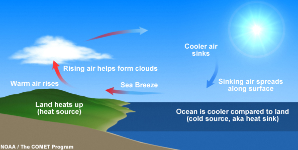
Basic schematic for a sea breeze. (NOAA)
In June, July, and August, when we are on the periphery of a high pressure system, Houston summers are like the ones your mom described. This is due to the sea breeze, a pattern in which the land heats up faster than the Gulf of Mexico. This typically happens during the late morning or afternoon hours, and the rising air over land forms clouds a few thousand feet up at the lifting condensation level. This can then lead to the development of showers and thunderstorms. Some summers, particularly the ones your mom remembers, can see this type of pattern persist for weeks.
–Eric
Q. I saw a (radar) effect I can only describe as a rain “splash” or “bubble”. This is a ring of what appears to be very light rain, that starts centered on a newly forming cell and expands in all directions, rather quickly, before eventually dissipating. It appears like a two-dimensional cross section of a bubble inflating, or the expanding wave one might see after tossing a pebble into still water. Are you familiar with this phenomenon?
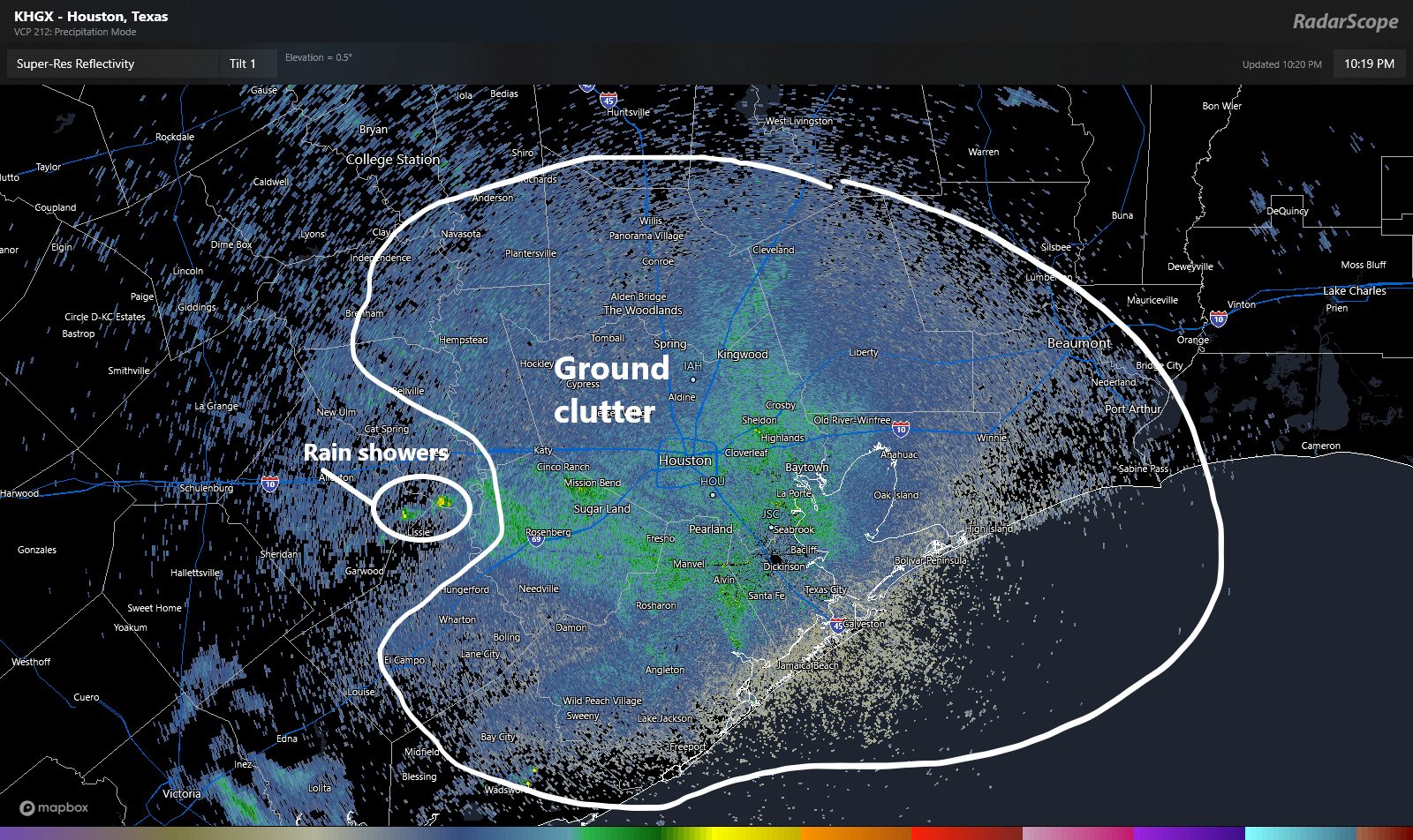
A. This is good opportunity for us to explain some common features you may see on weather radar that aren’t specifically precipitation. When you look at radar and you see what looks like a bunch of “noise,” as if there’s a bunch of light precipitation, we call this ground clutter.
An example of a radar image with a couple actual showers and a whole lot of ground clutter (birds, bugs, bats, etc.) from this past weekend. (RadarScope)
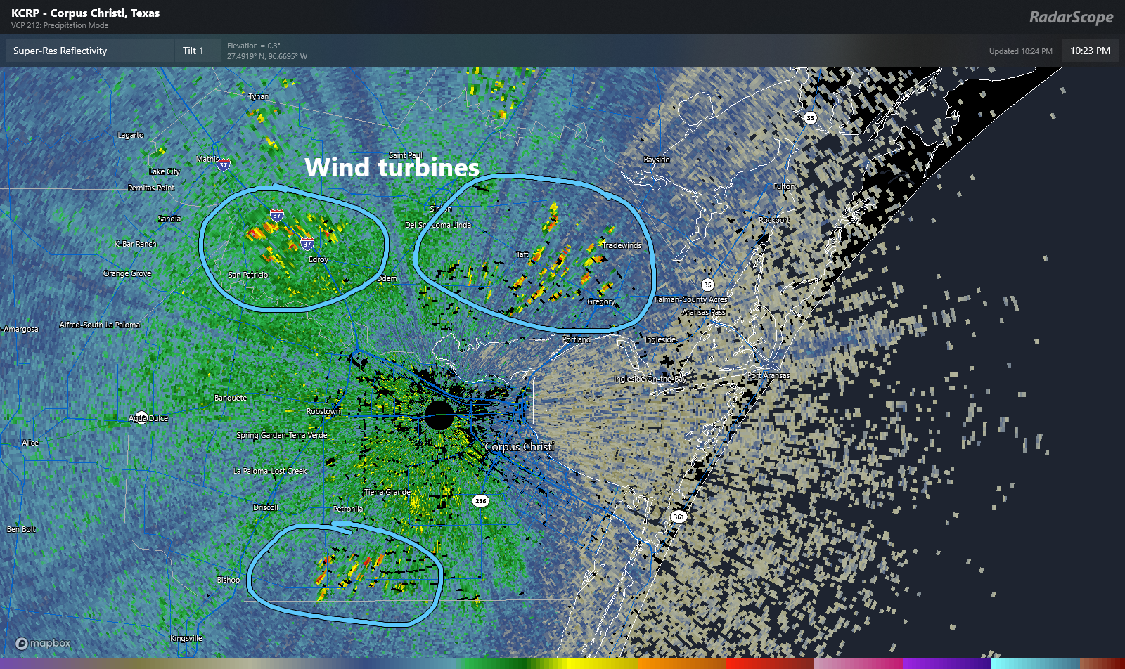
Ground clutter can literally be anything other than precipitation: Birds, bugs, bats, etc. can all make it up. You see it at every radar site. After awhile, you learn to disregard it. Radar can also pick up wind turbines.
Wind turbines as seen around Corpus Christi. (RadarScope)
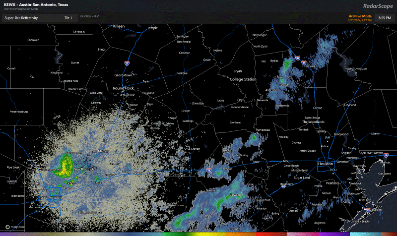
These can be a bit of a headache when you look at radar, but again, after awhile they sort of just become background noise to a seasoned user. I noted ground clutter above. How about bat colonies heading out for a night of snacking?
Bat colonies emerging across Central Texas after sunset, while light rain showers work south to north between Houston and San Antonio. (RadarScope)
Similar to bats at sunset, you can see birds emerging from slumber during the morning, a phenomenon that looks like something is literally exploding on radar. These are just enormous flocks of birds taking off for the day from various locations. We call these “roost rings.”
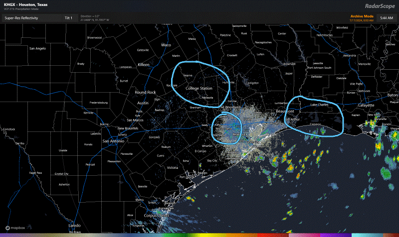
Roost rings on radar from July 17th, as large flocks of birds spread out in all directions after sunrise. (RadarScope)
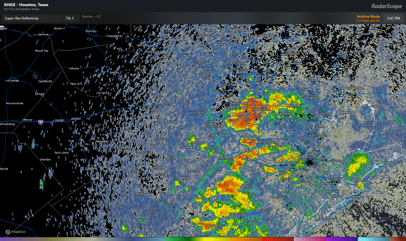
Then, I think we get to what this reader asked about. If you look at this radar loop from July 17th in the afternoon, you can see numerous showers and thunderstorms over the Houston area generally propagating westward.
Showers and thunderstorms firing up, weakening, and redeveloping to the west from July 17th. (RadarScope)
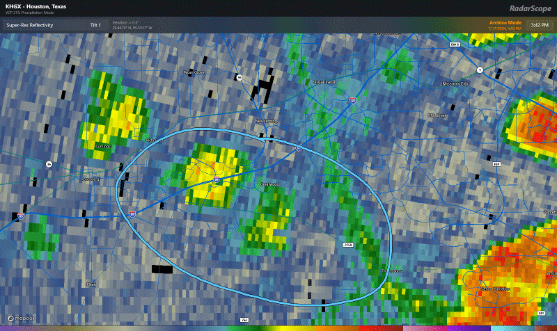
To the untrained eye, this is a chaotic mess of storminess. But if you look closer, the radar can actually tell you what’s happening here. Let’s zoom into Sugar Land and Greatwood down into Fort Bend County.
Outflow boundaries colliding to produce new thunderstorms southwest of Sugar Land. (RadarScope)
If you look right above and on the right side of what I circled on the loop above, you can see what looks like a “line” of green on the radar. We call these outflow boundaries or gust fronts. When we get thunderstorms, sometimes a cool breeze or cool gust of wind will move in before it starts raining. That’s what we call outflow, and you’re literally feeling the rain-cooled air come in ahead of the rain itself. In this case, outflow from the storms east of Greatwood, closer to Pearland was pushing west. Near Greatwood, it ran into another outflow boundary that was lifting northwest from storms down in Brazoria County. As the two boundaries collided, a new storm formed right over Highway 59/I-69, flared up and then weakened.
Such outflow boundaries are common in our area in summer. Sometimes, you’ll see what looks like outflow lifting north from the Gulf of Mexico. That’s the sea breeze, and once one storm pops on a hot day, it can create an effect of boundary collisions all over the place in erratic fashion. This explains why so often you’ll get a quick inch of rain whereas your neighbor 5 blocks away gets next to nothing. I liken it to atmospheric bumper cars: Pure chaos.
Anyway, now when you look at radar, maybe you’ll be able to detect some cool features too!
-Matt
Q. Do hurricanes come in clusters in certain parts of the Gulf and Atlantic? Several years ago, it seemed like Florida and the lower East Coast were getting slammed over and over. Then for a while the upper Gulf Coast was the big target. Is this faulty memory, or does this actually happen? And is it maybe the Texas coast’s turn?
A. The simple answer is: Yes, that can happen. Look back at 2020 when it seemed as if every storm had its mind set on Louisiana. But we can look back at some other seasons and see this concept in action. Let’s take 1995 for example.
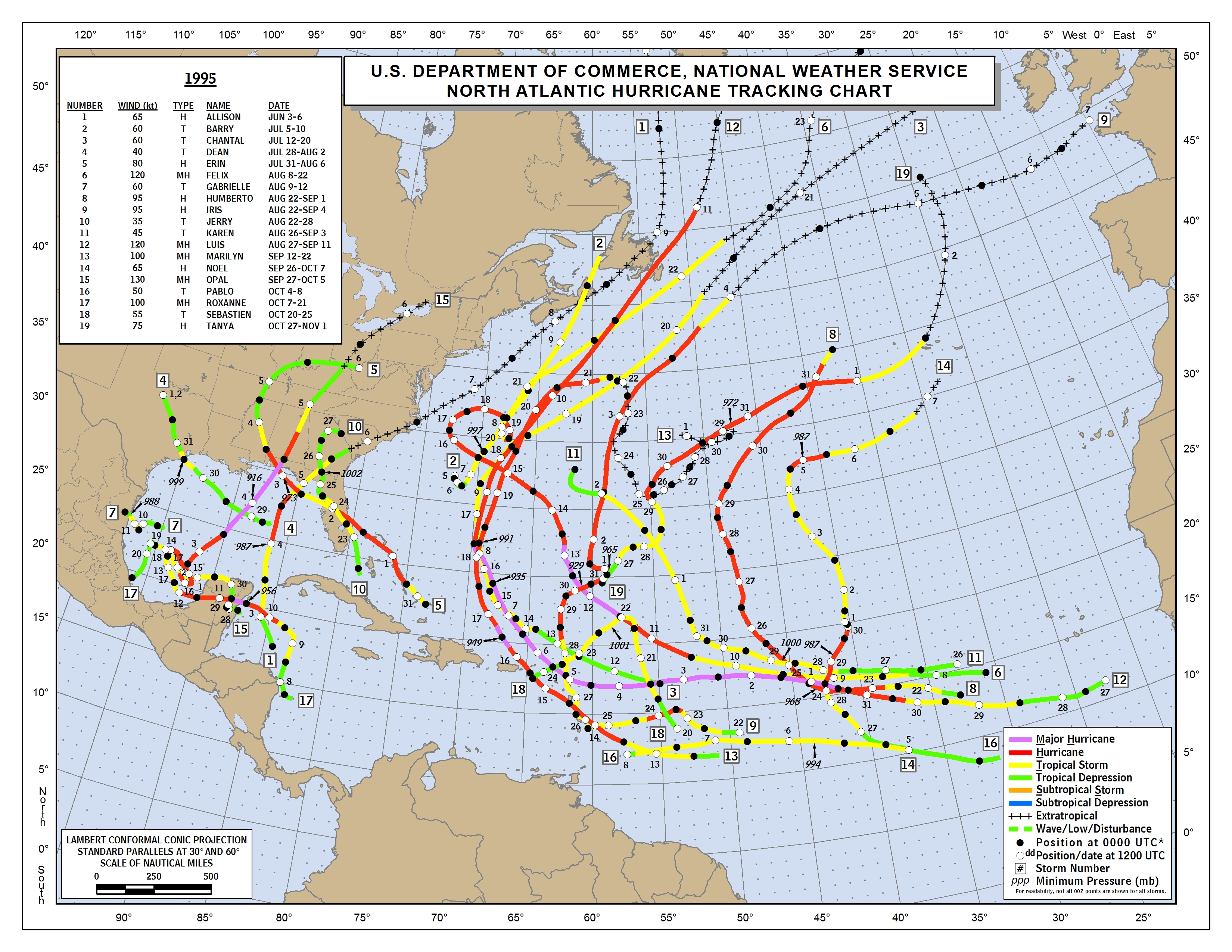
The 1995 hurricane season was active but also highly clustered. (NOAA)
In 1995, there were 19 total storms. Many ended up in the Atlantic, clipping the Caribbean islands or just wandering out to sea. There was a secondary cluster of storms in the Gulf, particularly near the Florida Panhandle. 2010 was another season like that, where we had lots of storms clustered into two distinct areas. The first was out at sea as in 1995. But the second was focused on Central America and Mexico. But then you get seasons like 2017, where anyone and everyone was in play for hits from storms.
The reasons are tough to explain in a simple Q&A, but in general: The weather pattern in summertime can be semi-permanent. In other words, the Bermuda high over the Atlantic can sit in place for weeks at a time. Like we experienced last summer, high pressure can sit over Texas for weeks at a time. When patterns like this happen, it can sort of lead the atmosphere to produce a more common outcome. Those features help steer storms, so when they don’t move, most storms will follow generally similar tracks. Each year is a blank slate, though various climatological cycles can possibly predispose a series of seasons to a more common outcome (see the 1950s on the East Coast of the U.S.).
So does that mean anything for this year? Our weather pattern this summer has been a little more chaotic, though it has firmed up some in the last month, trending more toward stagnant over Texas. That would theoretically put the East Coast or western Atlantic in play, not so much the western Gulf. And we’ve seen Ernesto (Bermuda) and Debby (Florida) do just that. Will that hold through October? No clue truthfully. But it would be nice for us to say Beryl was it for this year.
In brief: Houston will continue to see scattered showers and cooler temperatures for a couple of days. Then, rain showers should become more widespread during the second half of the week, and we are starting to see the possibility of heavy rainfall by next Monday or so.
Potential flooding
Over the last day or so, the model trends have been pushing toward a wetter pattern than expected for the next week to 10 days. Since the region has been so dry, and rain chances will be hit or miss over the next several days, I’m not anticipating any serious flooding during this week. However, in part due to a front stalling north of the region early next week, we could see the potential for more widespread and sustained showers.
The bottom line is that we’re watching things, and something like a Stage 1 flood alert may be necessary for early next week, potentially the Monday and Tuesday time frame, for coastal areas. Again, even in a worst case scenario, we’re probably talking about something that floods lower-lying streets. I just wanted you to be aware of our thinking.
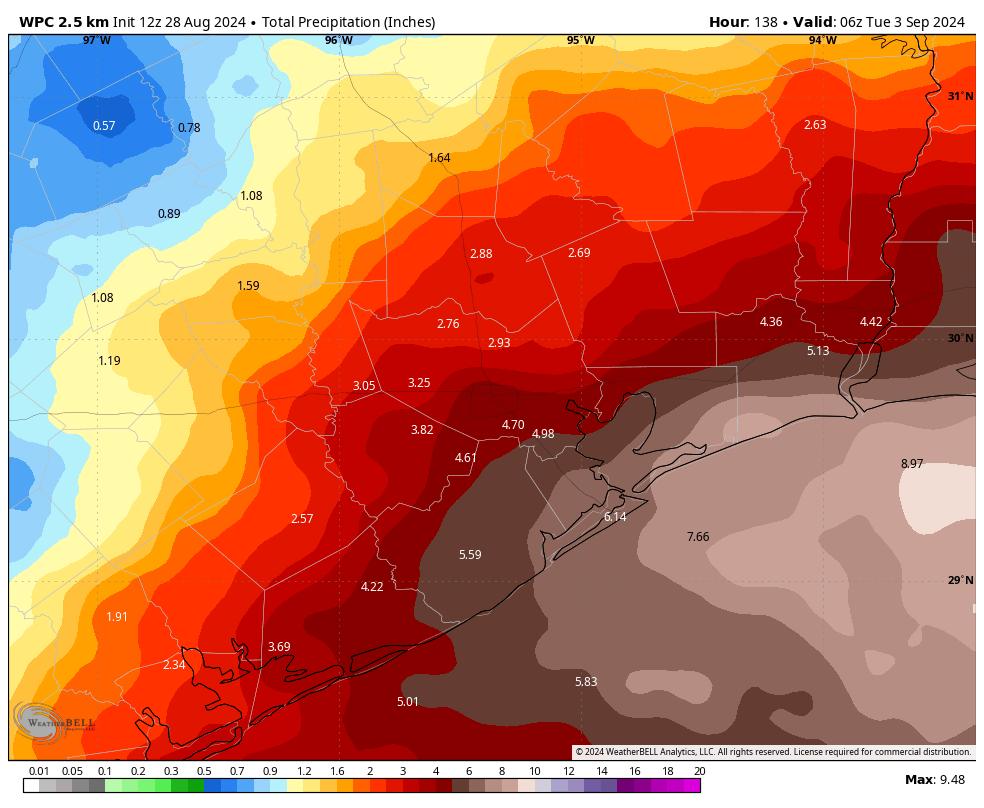
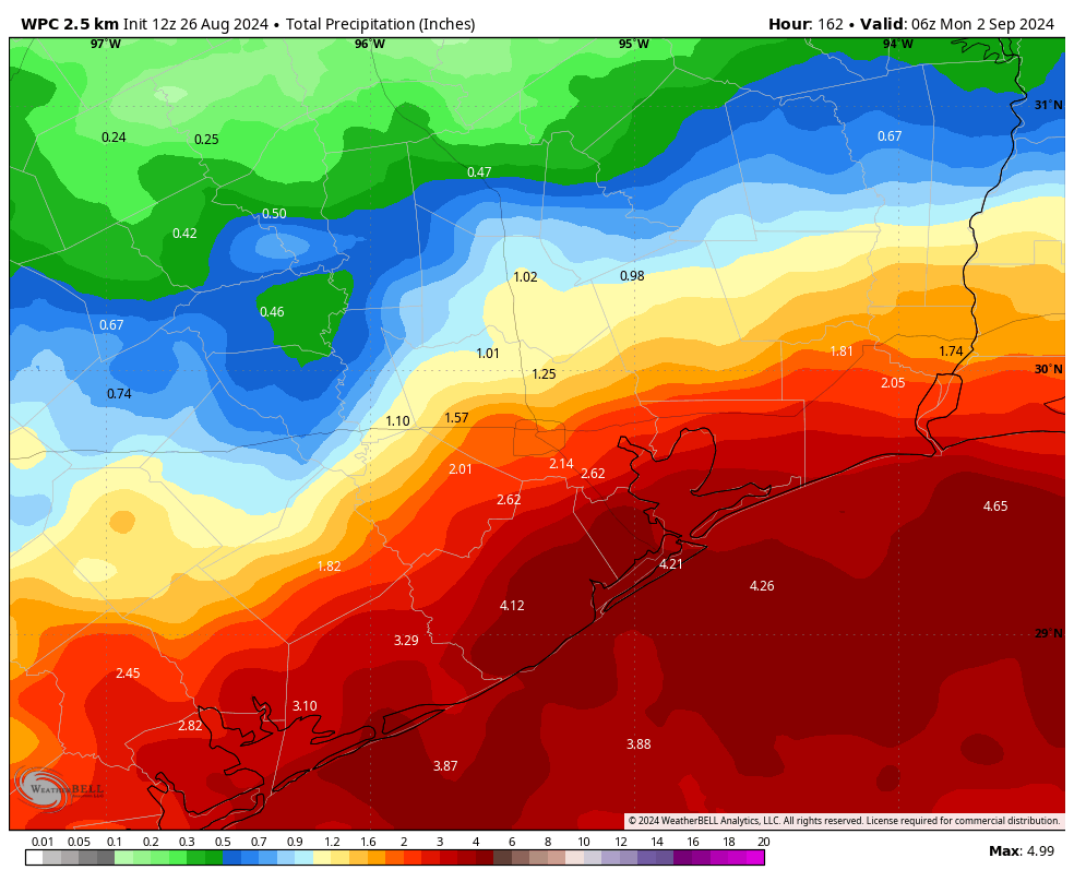
NOAA rain accumulation forecast for now through Monday night. (Weather Bell)
Tuesday
Today will be something of a repeat of Monday, with showers developing offshore and moving inland during the morning and early afternoon hours. However, coverage does look likely to be slightly less than on Monday. Skies, otherwise, will be partly sunny, with highs in the low 90s. Rain chances will slacken during the evening hours. Lows on Tuesday night will drop into the upper 70s.
Wednesday
Like on Tuesday, rain Wednesday will be of a fairly scattered nature, with perhaps only about half of the area seeing a passing shower. Accumulations should not be too significant, with the hardest hit areas perhaps picking up a half inch or so, and most of the region less. Highs, again, should be in the vicinity of the low 90s with partly sunny skies.
Thursday, Friday, Saturday, and Sunday
Rain chances will increase as we get into the second half of the week, and weekend. I can’t find much to differentiate the weather on any of these four days, which is why I’ve lumped them together. Each day is more likely than not to see rainfall, and there will be chances for showers overnight as well. High temperatures each day will range from the upper 80s to lower 90s, so quite a bit cooler than is typical for late August. I don’t really have any flooding concerns for this period, but showers could definitely put a damper on outdoor activities. It certainly won’t be raining all the time, but showers may pop up any time.
Early next week
As a front stalls north of the area, this should provide some additional lift and juice our rain chances. Since we’re talking about a period a week from now, the details are going to be hazy. But with the potential for widespread showers, and some heavy rainfall, we necessarily cannot rule out the possibility of some flooding. We’ll see. Daily highs will remain in the vicinity of 90 degrees. Most of our modeling shows rain chances slackening as we get toward the second half of next week, for what it’s worth. Which probably is not a whole lot.
Atlantic tropics
After a quiescent period, there is a new system to watch. There is a chance that an area of low pressure in the Atlantic could develop over the next week or so, as it moves toward the Caribbean Sea. Yesterday afternoon some of our best global models were hot to trot, and ready to develop this system into a tropical storm, but this morning they’ve backed off some. There’s not much else we can do but watch at this point—the next month is the period during which we should be most concerned about the potential for powerful hurricanes to strike Texas. For more detailed coverage, be sure to check out The Eyewall.
In brief: After a long, hot August the Houston region’s pattern will change significantly this week. In the absence of high pressure we’ll see significant daily rain chances and lower temperatures. Rain accumulations will be greatest near the coast, but even inland locations may pick up an inch or more of rainfall.
Up until this past weekend, Houston has largely been beneath a potent high pressure ridge this month. It has not been directly centered over the region, which is why daily high temperatures have not been as blistering hot as the summer of 2023. But our daily high this month has nonetheless averaged 98 degrees, with a total of eight days reaching 100 degrees or higher. Additionally, we have recorded almost no rainfall. Much of the region has received 0.5 inch, or less, for the entire month of August. It’s not for nothing that I believe August is by far the worst month of the year for Houston.
As we near the end of the month, this pattern is about to change. High pressure anchored over West Texas this summer has backed off, opening the door to moisture from the Gulf of Mexico. Accordingly, a pattern of showers and thunderstorms should persist through this week, and into the weekend. We can expect daily rain chances to go along with high temperatures generally in the low 90s. Overall I don’t have any real flooding concerns, but with the return of high school football and other sporting activities, you’ll definitely need to watch for the potential of showers and thunderstorms on a daily basis.
NOAA rain accumulation forecast for now through Sunday. (Weather Bell)
Monday
A low pressure system in the Gulf of Mexico will help to drive high rain chances today. These showers are presently lurking just offshore, and they should move inland later this morning and throughout the day. Rain chances today, and for much of the rest of this week, will be higher along and near the coast, closer to the source of moisture. But even areas well inland, such as The Woodlands and Katy, will have a decent chance of rainfall each day. Skies will be partly to mostly cloudy today, with highs of around 90 degrees or just above. Winds will be from the east at about 10 mph, with higher gusts. Low temperatures tonight will drop into the upper 70s.
Tuesday
Expect a similar pattern on Tuesday, with the potential for showers and thunderstorms. Not everyone will see rainfall, but a majority of the Houston area is likely to.
Wednesday, Thursday, and Friday
The general pattern of showers and thunderstorms developing offshore, and then moving into the Houston area during the morning and afternoon hours, should continue. Overall, our evenings should be free of rainfall this week, but I would not make any ironclad guarantees. Highs will continue in the vicinity of 90 degrees into the low 90s, a nice contrast to the heat from the rest of this month.
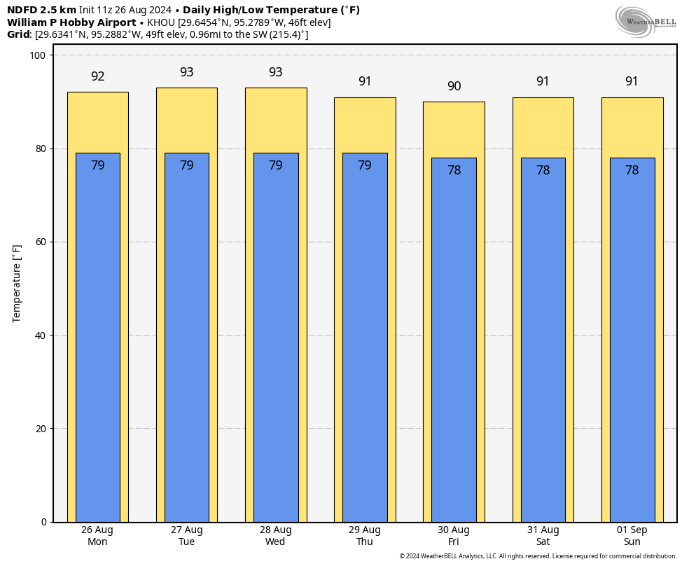
A mild end to the month of August in terms of daily high temperatures. (Weather Bell)
Saturday and Sunday
More of the same, probably. I think we’ll see highs in the low 90s this weekend, with a mixture of sunny and cloudy skies. Daily rain chances will, again, probably be 50 percent or higher, with better chances near the coast. Nights remain warm, with lows briefly dropping into the upper 70s.
Next week
There is some evidence in the global models of another surge in rainfall on Monday and Tuesday of next week, but that is far enough into the future that I’m not overly confident. In any case, the most likely outcome for weather next week is that this wet and somewhat cooler pattern continues for at least a few more days. There’s some evidence of a push back toward highs in the mid-90s during the second half of next week, but I could just as easily see us staying a bit cooler. We’ll see!