In brief: Summer’s here, and through Memorial Day you will find little to no relief in the area. From there, the weather pattern may get a little more unsettled next week, but nothing stands out that we can hang our hat on just yet.
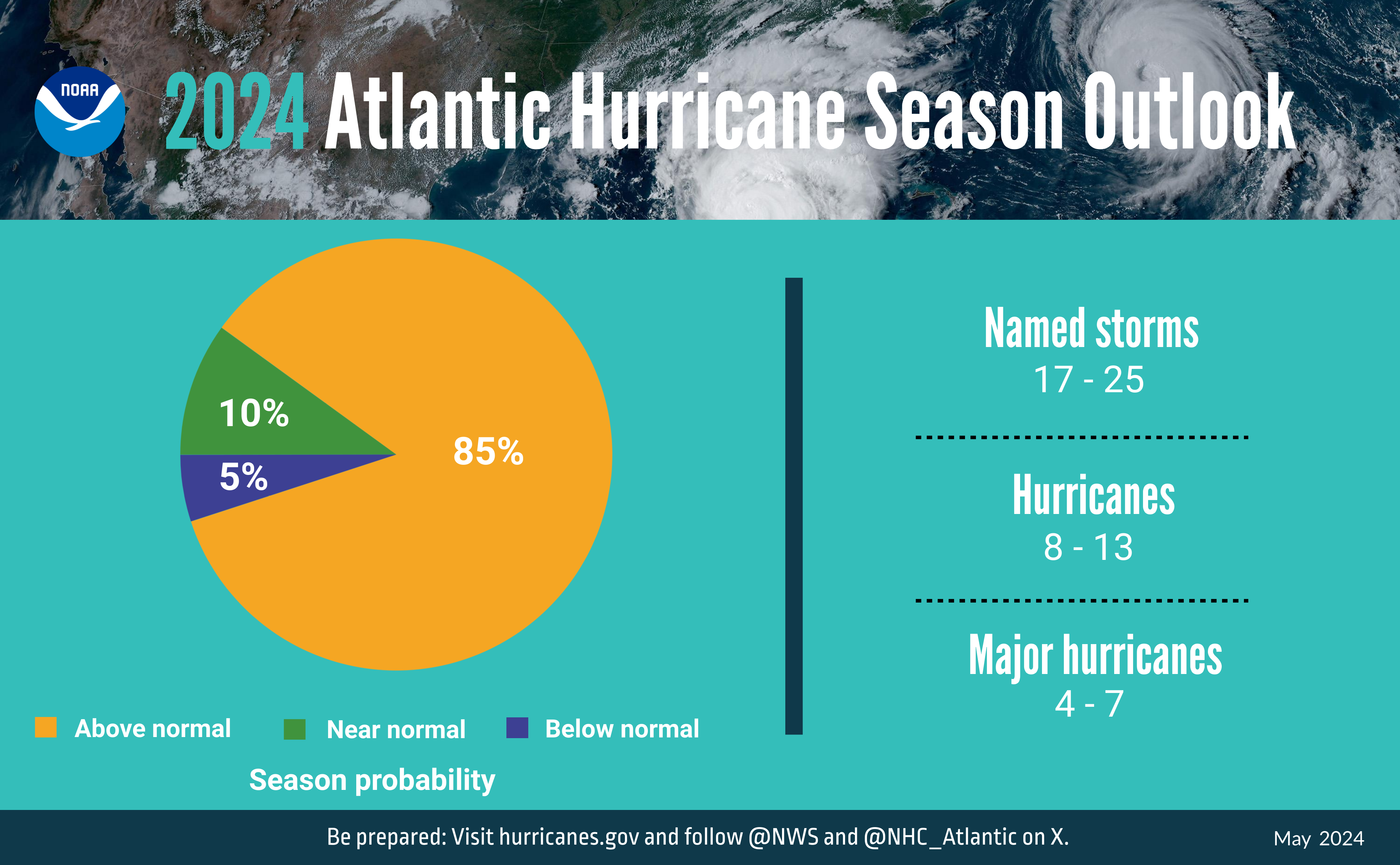
NOAA’s hurricane outlook has been published since 1999, and this is the most active one they’ve issued. (NOAA)
For those struggling with continued poor air quality thanks to the haze and smoke from agricultural fires in Central America and Mexico, I don’t think we will see much relief this weekend. I am hopeful we get a shift in wind next week though.
Yesterday’s low temperature at Hobby Airport was 80 degrees, the third time already we’ve failed to drop below that mark this year. We’ve already tied for the earliest first 80 degree morning on record at Hobby this year, on May 21st, matching the previous record set in 2022. We are running about a month and a half ahead of normal, for whatever “normal” is worth anymore. Today will be the seventh morning where the low temperature has failed to drop below 78 degrees, which sets a new record at Hobby for the most before June 1st. We should add at least three or four more days to that before we get a wee bit of relief next week just before the calendar changes.
Anyway, I write all this to say that this is not a normal start to summer. It’s hitting strong and fast. And don’t be shocked to see a heat advisory this weekend. Practice heat safety this weekend. Yeah, it’s Houston and it’s always hot in summer. But we are not yet acclimated to these temperatures for the season, so heat illness can come on quick and unexpectedly. Some of us are still cleaning up from last week or even still without power. Check on those folks, keep your pets cool, and look before you lock.
Today through Sunday
The front portion of the holiday weekend looks partly to mostly sunny and hot. Expect highs in the mid-90s and lows near 80, or essentially normal weather for late July, not late May.
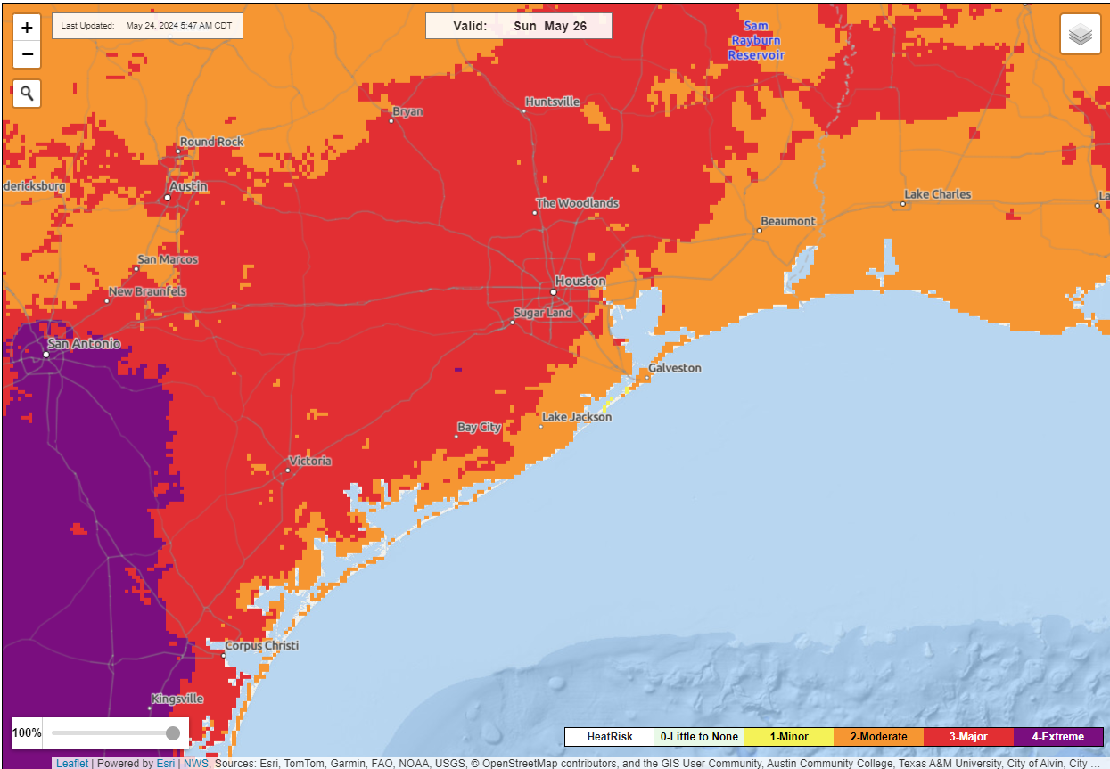
National Weather Service “Heat Risk” maps show pockets of “extreme” heat on Sunday very near the Houston area, becoming more widespread south of San Antonio. (NOAA NWS)
I would not be entirely floored to see an isolated thunderstorm roll through areas north of Houston, perhaps as close as The Woodlands or Magnolia. Most people will not see one, but if you do, it could rain hard for a short time, with lightning, gusty winds, or even some hail. Again, this is most likely to be isolated and north of Highway 105, but perhaps as close as Montgomery or northern Harris County.
Memorial Day
This should be the hottest day of the stretch. Expect mid to upper 90s and a mix of sun and clouds with just a slight chance of a late shower or storm north and west.
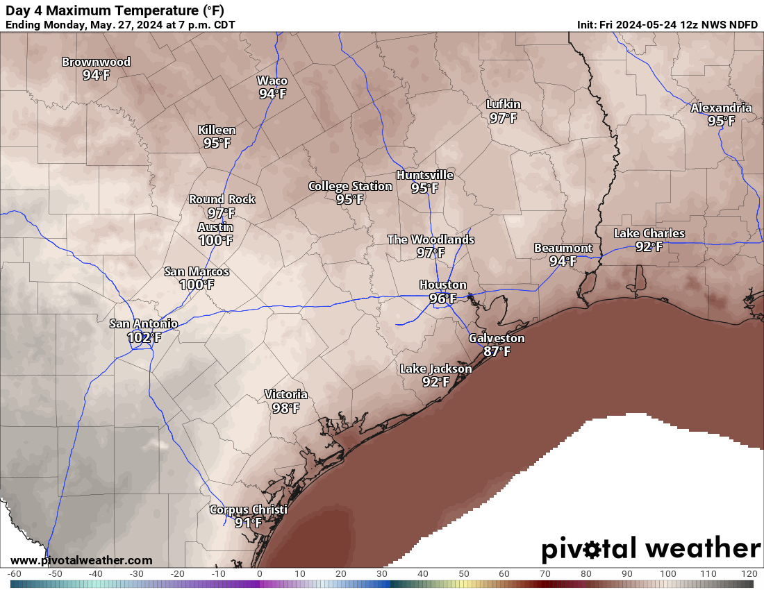
Monday’s high temperature will push into the middle or upper-90s. Maximum heat precautions should be taken. (Pivotal Weather)
Sunday and Monday’s heat will border on “extreme” levels, so maximum heat precautions should be taken here.
Rest of next week
Things start to change a bit next week. Temperatures will shift to become a little “less hot,” which means more like low-90s than mid-90s. Nighttime lows may drift back more into the mid-70s. A series of disturbances may try to erode away the northeast portion of the ridge of high pressure over Texas, so that could be just enough to fire back up some thunderstorms after Monday. I don’t even want to begin to speculate on timing or details or any of that. Just know that the stagnant pattern of this weekend may change a bit next week.
In brief: After a few mostly cloudy days we’ll see increasingly clear skies and this will help temperatures march upwards. We’ll go from highs in the low-90s today, to mid-90s this weekend to upper-90s by Memorial Day. After that a weak front will provide some modest relief.
Thursday
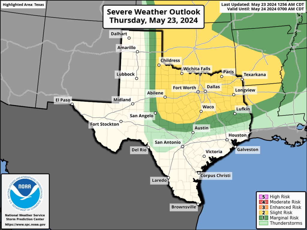
After a cloudy start we should see partly sunny skies this afternoon, and this should help to push high temperatures into the low-90s. Winds will blow from the south at 10 to 15 mph, with occasionally higher gusts. Once again, we should see some fairly strong storms develop in central Texas to the north of Austin. While these will propagate eastward, I expect them to remain north of Highway 105 once again, with no impact on the greater Houston metro area. Low temperatures tonight will only drop into the upper 70s.
Some severe storms will be possible, once again, far to the north of Houston later today. (NOAA)
Friday
A day very similar to Thursday, although high temperatures are likely to be a degree or two higher.
Saturday and Sunday
We’ll see mostly sunny skies this weekend, with high temperatures solidly in the mid-90s. We will be hitting our first highs above 95 degrees nearly three weeks earlier than normal, in case you were wondering whether this is typical weather for late May. It’s not. Nighttime lows remain sultry, around 80 degrees.
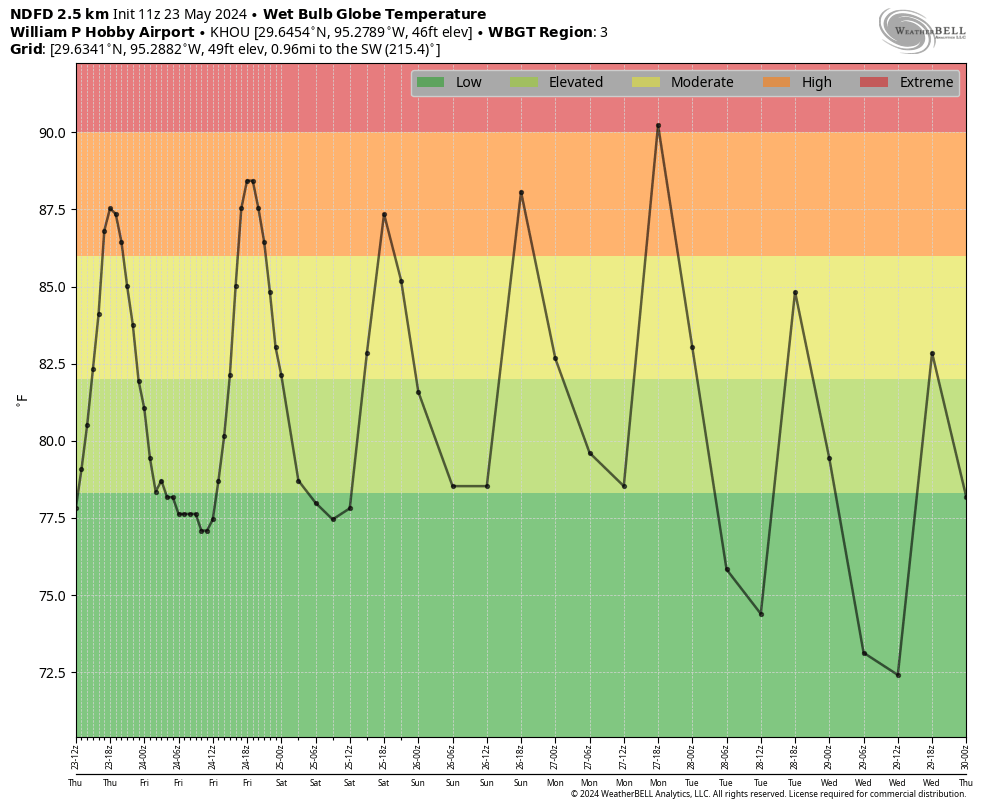
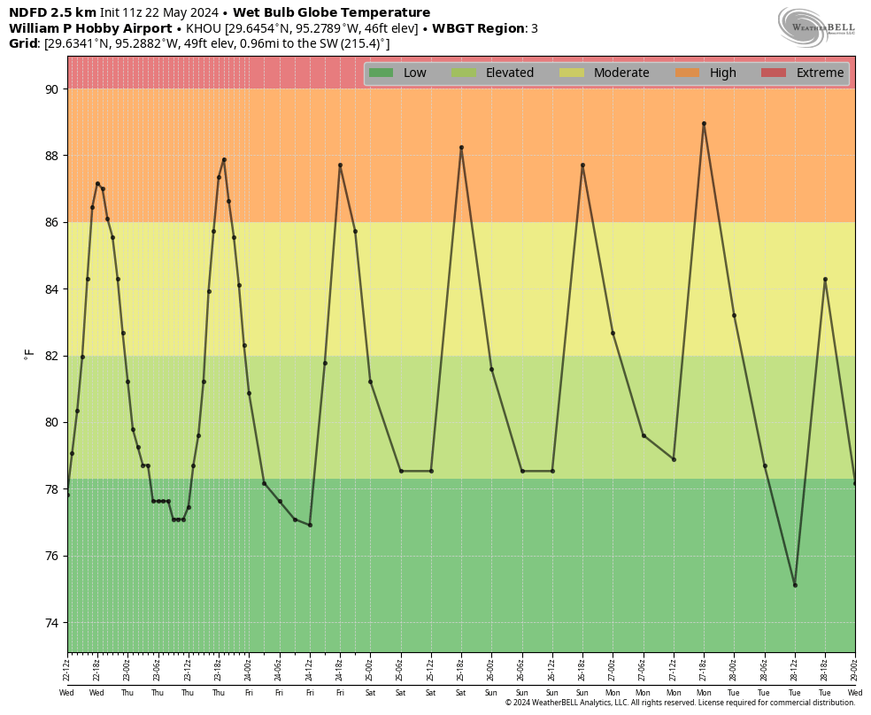
Wet bulb globe temperatures for this week. (Weather Bell)
Memorial Day
Everything comes together on Monday, sunny skies and the characteristic jump in temperatures associated with an approaching front, to push our highs into the upper 90s. If we look at wet bulb globe temperatures—a measure of heat stress in direct sunlight that takes into account air temperature, humidity, wind speed, sun angle, and cloud cover—we see the potential for an ‘extreme’ day in terms of heat. Please bear this in mind if you have outdoor activities planned.
Tuesday and beyond
We’ll see a slight chance of rain on Monday evening as the front approaches and moves through, but for now I don’t expect anything more than a dusting of showers. Highs next week look more reasonable, in the low 90s, with overnight lows perhaps in the mid-70s. We’ll also see some daily rain chances in the Wednesday through Saturday period, although they may be of the 20 percent daily variety. I’m not sure yet. In any case, the very end of May should see a bit of a return to normalcy.
In brief: This post explains what a derecho is, where the term came from, and talks a bit about some past thunderstorms of note in Houston.
What is a derecho?
The National Weather Service has concluded that Thursday’s severe storms in Houston constituted a derecho. So what does that mean?
First off, it’s pronounced “deh-REY-cho.” Meteorologists have debated what the definition of one of these things actually is for years. And we still don’t have a concrete, universally accepted definition. However, progress was made after a 2011 storm that hit the Southeast and a 2012 derecho that ravaged the Mid-Atlantic and Midwest to work toward something more widely accepted. Ultimately, NOAA/NWS defines a derecho as a continuous or intermittent path of wind damage from a squall line of thunderstorms, bow echo, or quasi-linear convective system (QLCS) that extends at least 400 miles and is at least 60 miles wide. In other words: It’s a swath of wind damage from mostly non-tornadic thunderstorms that extends for 400+ miles and is at least 60 miles wide.
What makes it different than typical severe thunderstorms?
A derecho, as noted above can be a squall line, bow echo, or QLCS. We get several of those types of events every year in Houston. What sets a derecho apart is the wind damage. It’s not normal. It’s not a couple trees on power lines. It’s a lot of wind damage over a long path.
Are all derechos the same?
No! Derecho events are broken down into three categories: Serial, progressive, and hybrid. A serial derecho is basically where you have one giant squall line that is hundreds of miles long with multiple embedded bow echoes producing widespread wind damage. A progressive derecho is the one we experienced in Houston last week that is typically no more than about 250 miles wide. You also have hybrid outcomes, which basically share characteristics of the two others.
Why is it called a derecho?
According to NOAA, Dr. Gustavus Hinrichs, who was a professor at the University of Iowa coined the term in 1888. The literal Spanish translation of derecho is “straight ahead” or “direct” or even “right.” Here’s where the etymology gets kind of fun. “Tornado” derives from the Spanish “tronada,” which literally means thunderstorm. But there is also a Spanish word “tornado” which essentially means “twisted,” and it derives from the Spanish verb “tornar,” which means “to twist.” So essentially, Hinrichs took the “opposite” of twisted and decided that derecho (or “straight”) would be a good way to distinguish tornado-like wind damage that was not caused by a tornado.
Are derechos common?
The short answer is: Kind of. The most recent derecho prior to Thursday’s in Houston occurred back on April 1-2 from just west of Missouri through West Virginia. A storm that almost met derecho criteria occurred just this past weekend in Kansas and Missouri. There were derechos in 2023, 2022 in Canada, 2021, and so on. In fact, the quad-state area around Kansas, Missouri, Arkansas, and Oklahoma northeast of Tulsa averages more than one derecho per year.
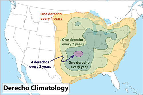
A climatology of derechos. Houston technically falls under the once every 2 to 4 year categorization, but that may be a bit generous. Often they just start around here or mostly pass to our north. (NOAA)
Derechos are most common in May, June, and July. Keep in mind that a lot of the areas that see derechos every 1 to 2 years are more rural, so it’s likely you hear less about them than when they hit places like Chicago or DC or Houston directly, causing billions in damage.
The Houston area’s history with derechos and thunderstorm wind events
There are a few thunderstorm wind events and derechos that have stood the test of time in this area. First and foremost was just last summer when a squall line delivered a 97 mph wind gust to Bush Airport.
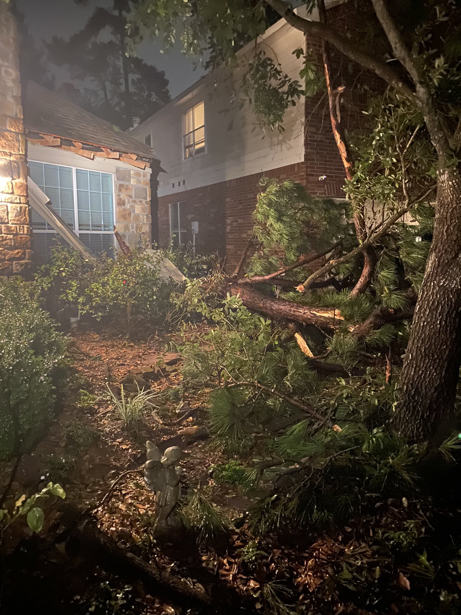
Damage from the June 2023 storms in Montgomery County (Susanna Sovran Cronin)
That storm on June 21st was one in a series last June that caused damage across the area. It was not a derecho, but it certainly caused severe damage north of downtown Houston.
A storm system in 2002 did a good bit of damage, including to the I-10/Gessner area, according to the Houston Chronicle’s archives. Just shy of $1 million in damage was reported with fortunately no injuries.
In early May 1993, a powerful squall line knocked out power to 200,000 homes in Harris County and went on to rampage Galveston County, causing at least $50 million in damage and delivering a 98 mph wind gust to Scholes Field in Galveston.
The front page of the May 3, 1993 Galveston Daily News after a storm with winds as strong as 98 mph hammered areas southeast of Houston. (Galveston Daily News)
While not Houston, the “Texas Boaters’ Derecho” of May 1986 makes the list of memorable derecho events in the United States. You can read a full summary of the event on page 20 of the May 1986 NOAA StormData publication.
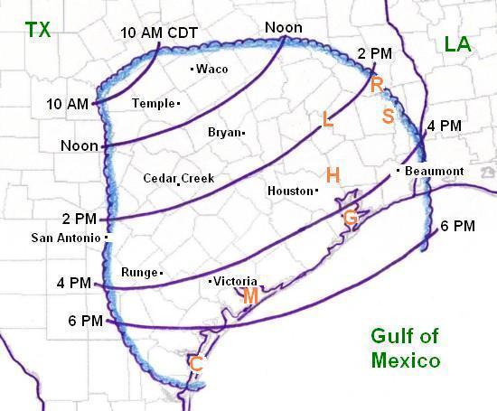
A map of the path of the May 17, 1986 Texas Boaters’ Derecho (NOAA SPC)
It’s tough to find a lot of good information on how this particular event impacted Houston specifically, but it is infamous due to the fact that it drowned six. There was a fishing tournament and boat race on Lake Livingston that day when the storm hit, bringing winds estimated to be 90 mph and waves of 10 feet on the lake. Much like we see with the damage from this year’s derecho, there were pockets of more significant damage within a broad damage field during the 1986 storm.
May 1983 storms
Thanks to Bill Read for pointing this one out to us last week. Three years prior to the ’86 derecho, a particularly bad thunderstorm event impacted much of the Houston area.
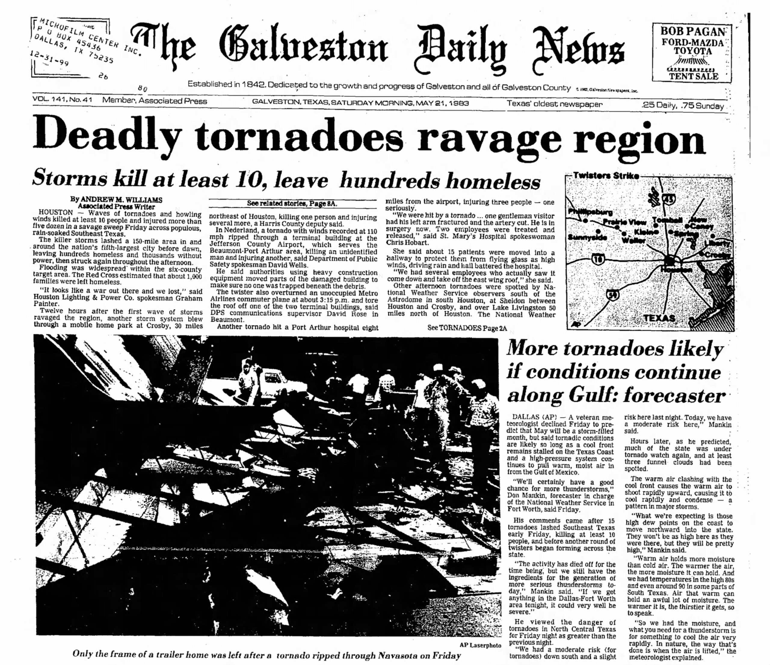
Front page of the Galveston Daily News the day after 4 significant downburst events and 8 tornadoes tore across the Houston metro area on May 20, 1983. (Galveston Daily News)
According to NOAA’s May 1983 StormData, approximately four downburst events, including one over the city of Houston, combined with eight tornadoes for a deadly severe outbreak in our area. Winds were estimated at 75 mph or stronger in spots, with several transmission towers crumpled over, much like in this month’s event.
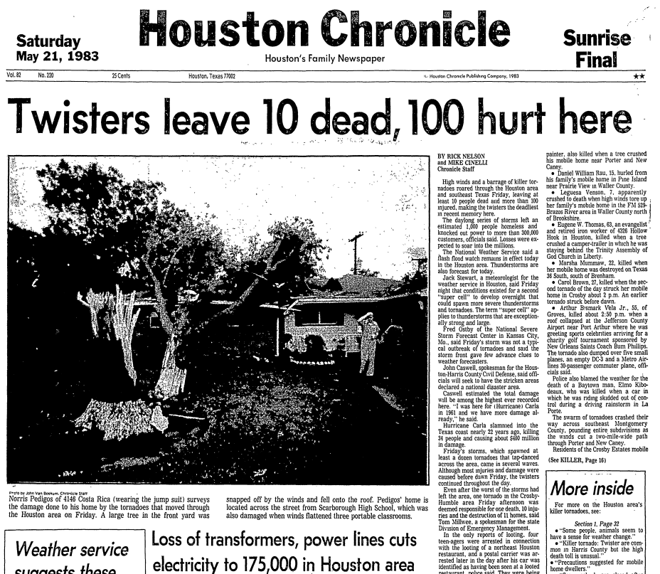
Houston Chronicle front page the day after the deadly May 1983 thunderstorms and tornadoes. (Houston Chronicle)
Over 300,000 customers were left without power in that storm, which would have been a bit less proportionally to this year’s storm. Winds were measured as strong as 110 mph during a tornado in Nederland, near Beaumont with this one. According to a Houston Chronicle recap of this event at the time, the spokesman for the Houston-Harris County Civil Defense stated that the damage was worse than in Hurricane Carla in 1961.
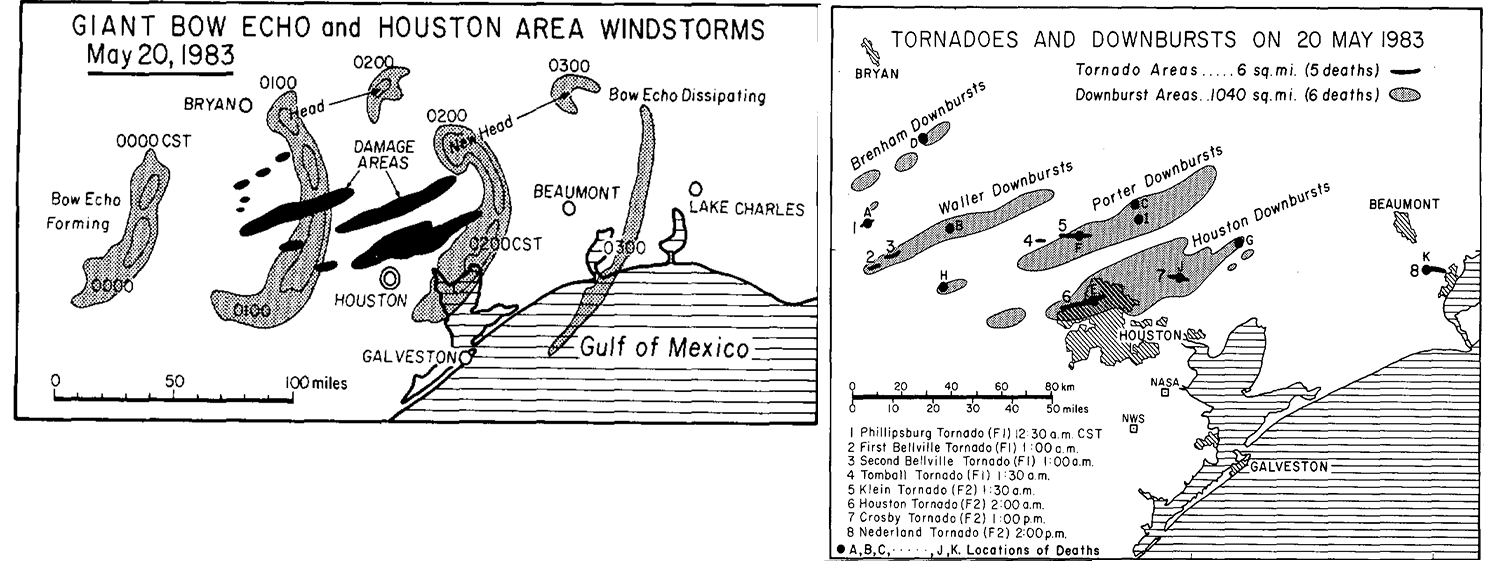
Maps (click to enlarge) showing the track of the bow echo from west of Brenham through Lake Charles and where the tornadoes and widespread wind damage occurred. (NOAA)
Approximately 10 people died with over 100 injured from this storm. Arguably, this was the previous worst non-hurricane wind storm in Houston until last week’s. It’s tough to find an official estimate on the damage caused by the May 1983 event, but it was likely in the tens of millions of dollars at the time.
Other events that seemed to garner some attention were a combination of severe storms and tornadoes on May 2, 1979, which primarily impacted western and northwestern parts of the area. On May 7 of 1976, significant wind damage occurred east and southeast of Houston, along with a few tornadoes nearby. The Exxon facility in Baytown apparently observed winds of 90 to 95 mph with considerable damage in that community. Back on June 4, 1962, a torrential squall line of storms seems to have had something of a similar impact on parts of the city as the recent derecho. Many people lost power, wind gusts hit at least 75 mph, and some windows were blown out downtown.
Houston Post front page form June 5, 1962 showing damage to the Windsor Plaza Shopping Center on Richmond, along with some other interesting items. (NewsBank)
While last week’s derecho was extreme by any real definition of Houston thunderstorms, I think we can assume that perhaps the return period on such a storm may be less than we might have thought. And Houston can now add destructive thunderstorm winds to a litany of periodic weather disasters including freezes, floods, hurricanes, extreme heat, and drought.
In brief: A dying front brings a chance of storms well to the north of Houston tonight, but for most of us the story remains one of heat. Temperatures will peak over the weekend, with Memorial Day looking especially hot.
Wednesday
Expect another warm day in Houston, with highs of around 90 degrees due to mostly cloudy skies. It will be a little windier than Tuesday, with southeasterly gusts up to about 20 mph. With the humidity, it will feel plenty hot outside during the daytime hours before lows drop to about 80 degrees tonight.
There is a healthy chance of storms well to the north of Houston later today and tonight. (NOAA)
For areas north of Houston, and by this we are probably talking about locations north of Highway 105 in Montgomery County, there is a chance of storms later this evening and during the overnight hours as a dying frontal boundary pushes a line of storms through northern Texas. There is some question as to how far south these storms will get. It is possible that locations such as College Station and Huntsville could see some thunderstorms tonight. There is even a slight chance that locations further south, including The Woodlands, could see some of this action. However, I think a capping inversion will probably prevent such activity for most of the Houston metro area, including at least the southern half of Montgomery County.
Other than this, we should be rain-free through the weekend.
Thursday
Expect partly sunny skies and a high of about 90 degrees with plenty of humidity. Another warm night.
Friday
As skies turn mostly sunny, expect highs to nudge up into the low 90s with plenty of humidity.
Saturday, Sunday, and Monday
The holiday weekend looks hot and sultry. Highs will rise from the low 90s on Saturday to the mid- to upper-90s by Memorial Day with mostly sunny skies. Folks, it’s going to be Houston hot this weekend, so take all appropriate heat precautions. That includes sunscreen during the daytime with the Sun reaching an angle of 80 degrees during the early afternoon hours.
Wet Bulb Globe Temperature forecasts give a sense of the heat to expect this weekend. (Weather Bell)
Next week
So what happens after Memorial Day? It still looks like some sort of weak front arrives on Monday night or Tuesday. It’s late May, so your expectations should be for slightly cooler weather, and slightly drier air, and not much more. Still, beggars cannot be choosers at this time of year. Rain chances look a little bit improved later next week, but we’ll have to see about that. I don’t have much confidence in such a prediction.
Last week’s storms
Check back later this morning as Matt has a post on last week’s storms, and where they share some commonality with Houston’s history of similar events. It’s a great article with a lot of historical context.