A couple quick housekeeping notes today before we get into things. First, our annual fundraiser will end soon! We are grateful for your support so far, and if you want to purchase merchandise to be shipped in time for Christmas or just simply make a donation, you still can here. Thank you!
Houston’s KHGX radar maintenance
With rain in the forecast and at least the potential for some strong to severe storms tomorrow, Houston’s primary Doppler radar is offline for maintenance. You may say, “Why on earth would they do that?” Unfortunately, there’s no real time of year here that’s better or worse; it can storm all 12 months of the year. The maintenance necessary to replace the radar pedestal (extending the lifespan of the radar another 20+ years) is extensive and requires a lot of planning. So it’s not something they can just pause or shift. The good news is that Houston has two terminal Doppler radars (TDWRs) that cover most of the metro area, and adjacent radars to ours will provide imperfect but mostly adequate coverage through the outage.
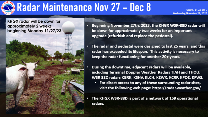
For those of you that use our app for radar coverage, there is a workaround. If you tap the radar in the app, you’ll notice two diamonds, one on the south side of Houston and one on the north side. Those are the aforementioned TDWR’s from Tomball and Pearland, and you should be able to pull data from those, covering essentially the entire metro area. If you live outside the city and suburbs, you can move the map around to a few other options. To the west, the radar north of Austin can cover most of the northwest fringe areas outside the Houston metro to about College Station and Brenham or so. Corpus Christi’s radar is useful for Matagorda Bay up through maybe Wharton. Lake Charles’s radar will cover the east side adequately to just east of Baytown. Coverage between about Huntsville and Lufkin will be a little trickier, but Shreveport and the Tomball TDWR will help there. Inconvenient for sure, but not a calamity, and this is great news for the long term health of our area’s extremely valuable Doppler radar.
Today
Wednesday will be a fairly calm day across the area. No trouble yet. We’ll see clouds roll in and thicken up from south to north through the day. They’re already starting to do so in fact. But some of the lower clouds could scour out by late morning before more clouds increase again later. Temperatures should peak in the mid to maybe upper-60s later today.
Tonight
Look for winds to kick up tonight, especially at the coast, where they could gust to 30 mph or so by morning. Scattered showers will spread north and east through the night, arriving in the Matagorda Bay area by midnight and across the rest of the metro area by morning on Thursday. Temperatures will only drop back a few degrees overnight, into the low-60s or so. They should even climb some toward morning.
Thursday
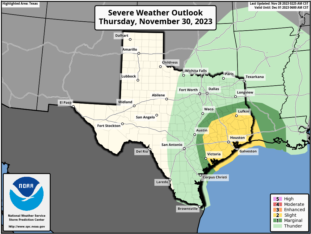
In a couple words: The worst of the weather tomorrow should occur from about 8 AM to 4 PM, with strong to locally severe thunderstorms, capable of producing strong winds, hail, and isolated tornadoes, as well as heavy rain.
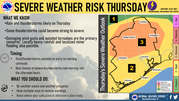
We will have a couple things to watch for on Thursday. First and foremost, strong to severe thunderstorms may begin to break out across the area as early as the back half of the commute, after 8 AM or so. The atmosphere looks fairly primed to produce storms with strong winds, potentially some hail, and even a tornado or two around the region. This doesn’t look quite as foreboding as what we experienced almost a year ago back in January with the Pasadena tornado (which was an exceptional setup for severe weather here), but the parameters are definitely aligned for at least some severe weather.
More technically: There’s a pretty healthy amount of wind shear (wind changing direction with height) available tomorrow. You need wind shear for severe weather and tornado risk. But the window for that severe weather and tornado risk tomorrow looks conditional and narrow. In other words, we need the appropriate amount of instability to realize to generate thunderstorms. And on top of that, we need the storms to be able to tap into that shear and instability at low levels. This is not a slam dunk case for severe weather, but it’s enough to say that if storms can realize their full potential tomorrow there could be a couple tornadoes, especially north of I-10. We should have a better idea on this tomorrow and will have more for you before it gets messy out there.
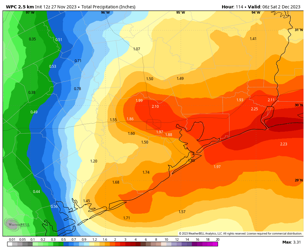
In terms of rainfall, we are not expecting significant or widespread flooding. But street flooding is a decent possibility in a few spots tomorrow. Most areas will see a half inch to inch or so of rainfall, but a couple isolated spots will almost certainly see 2 to 3 inches of rain or even a bit more, much of which could fall quickly.

All this should start to clear off to our east by late afternoon and evening, leaving us with clouds and a few showers. Temperatures and humidity will build up tomorrow, with highs near 70, and you’ll feel the dampness.
Friday
The forecast gets a bit trickier on Friday. The storms of Thursday will be well off to our east as a cold front slips into the region. However, it looks as if this front may stall near the coast or just offshore. This would keep us generally a bit cloudy and unsettled with shower chances, depending on exactly where it stalls. Temperatures will be mainly in the 60s, with 70s will be possible near the coast on Friday. The exact placement of the front will determine how warm it is on Friday.
Weekend into next week
That front may backpedal onshore Saturday, bringing more clouds and showers. Morning lows will range from the 50s inland to 60s near or south of the front. By Sunday, the stalled front should be escorted out into the Gulf by a second cold front which will usher in cooler, drier air and hopefully some sunshine for early next week. Admittedly, I’m skeptical about much clearing right now but we’re still several days out.
Texans tailgating looks okay right now, with temperatures probably in the 50s to low-60s most of the morning, warming into the mid-60s or so for the afternoon. I’m not going to completely rule out a shower, but I would lean toward drier weather at the moment.
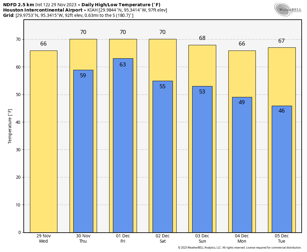
Temperatures will drop to the 60s for highs, 40s for lows early next week, and another warming trend may impact us next weekend.