Good afternoon. As expected, it’s an absolute burner out there today. Houston’s official weather station at Bush Intercontinental Airport has already reached 108 degrees as of 4 pm CT, which is 1 degree short of the city’s all-time heat record of 109 degrees. (We matched that record high on Thursday, you may recall). It’s now a race between temperatures and approaching rain showers.
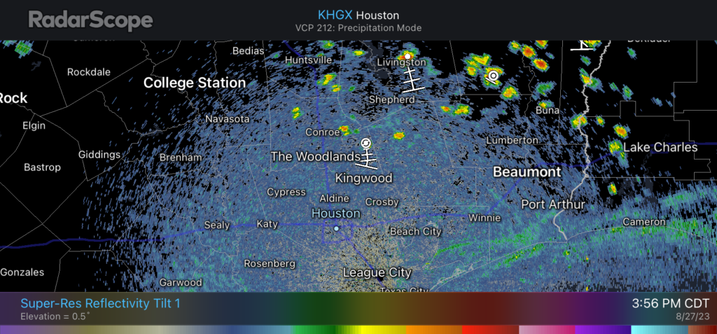
In Friday’s forecast we mentioned the possibility of some late afternoon showers and thunderstorms developing on Sunday, associated with a weak boundary. We are now starting to see those showers forming north of the Houston metro area, and they should gradually move southward into the region throughout the evening hours. Areas where precipitation falls will see drops in temperature associated with rain-cooled air.
Rain showers were starting to pop up just before 4 pm CT in Houston. (RadarScope)
To set expectations, these showers will be very hit or miss. Lucky locations will pick up a few, quick tenths of an inch of rain, whereas other observers will look longingly as the dark clouds and see little, if any precipitation. At this point it looks like the stronger storms are more likely to develop north of Interstate 10, but areas all the way down to the coast at least have a puncher’s chance of seeing some shower activity.
We are entering a brief period where rain will be possible, essentially this evening through Tuesday morning, before a weak front brings some drier air and shuts the door on rain chances for awhile. We’ll have the full story on the forecast ahead in our post on Monday morning, but just wanted to jump in on a Sunday afternoon with a heads up about the rain chances this evening. Good luck out there!
Thursday was a day for the books in Houston. Hobby hit 107°, Huntsville hit 111°, but the 109° at Bush is only the third time on record we’ve ever recorded a temperature that hot in Houston. It was last done on August 27, 2011 and prior to that on September 4, 2000. Yesterday was also our second hottest day on record by average temperature (high + low divided by two). Even Galveston got into the act hitting 99 degrees for the first time since 2012.
Thursday was one of the hottest days ever recorded in the Houston area. (NOAA)
While I would hesitate to say we’re going to get a reprieve today and tomorrow, the heat should be a little less intense, if only by a few degrees. There is a chance that we make a run deep into the 100s again on Sunday before some changes.
Not only was yesterday a historic heat day, it snapped a record streak of 48 consecutive days without measurable rainfall at IAH, which is the official Houston record now for longest dry streak. Hobby saw a storm in late July that has kept 2023 off their list of longest dry streaks (it did not rain there so yesterday was day 30 in a row; the record is 58 in spring of 2011). Not everyone saw rain yesterday, but some did, and it even led to some damage in Kingwood, most likely from downburst winds. We will have some other rain chances over the next few days, but just be warned that not everyone will get to partake.
The entire Houston area is in “extreme” or “exceptional” drought, meaning it’s getting very, very serious. (US Drought Monitor)
We aren’t running into critically severe drought issues with things like water supply. Yet. Water restrictions are spreading however. But we are tinder dry in many parts and it continues to produce wildland fires. We’ve heard from some folks watching their foundations closely as well. So, yes, we need more rain.
Today & Saturday
Expect sunshine and clouds. We’ll top off in the low to mid-100s, with some humidity. It’ll be another day of heat advisories and excessive heat warnings. Rain chances will be in the 10 to 20 percent range today, mainly north of I-10. Areas to the south will probably be in the 5 to 10 percent range. Tomorrow’s rain chances are probably a little less than that.
Sunday
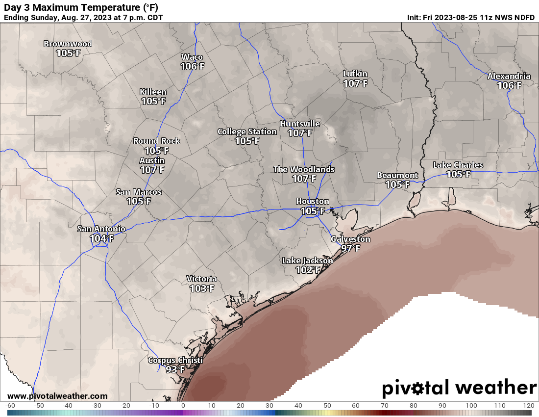
We should see a slight spike in temperatures Sunday, relative to Friday and Saturday. So look for highs well into the 100s on Sunday afternoon.
Sunday afternoon will rival last Sunday and yesterday for one of the hottest days of summer. (Pivotal Weather)
A few late day or evening storms may pop up, some of which could be on the stronger side, moving northeast to southwest across the area.
Monday through late week: Some good news
More of the same on Monday, with highs approaching the mid-100s again. Areas south of Houston could push deep into the 100s again. However, we have a front. This is not an autumn cool front, but it is a bit of a humidity boundary. This will probably swing through the Houston area Monday night or Tuesday. As it does so, showers and thunderstorms will be at their best chances. Not everyone will see rain, but it could be heavy at times where it falls. Coverage may be on the order of 30 to 40 percent or so.
Behind the front, it won’t be refreshing, but the mornings are almost certainly going to be noticeably less stifling. Look forward to that on perhaps Wednesday and Thursday morning. Daytime highs will have a bite taken from them, so instead of low to mid-100s every day, we’re probably looking at upper-90s and some low-100s. I’m not sure if we’re going to entirely rid ourselves of heat advisories, but we should have some days that will be comparatively “not bad” for this summer.
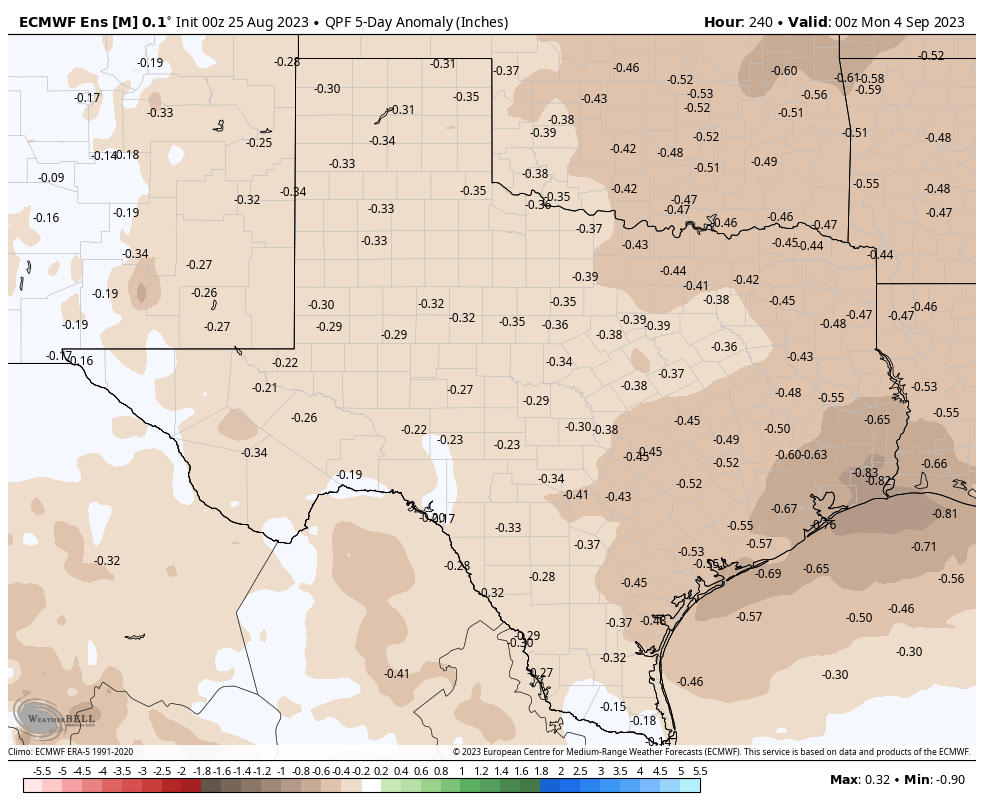
With a front pushing offshore, it will feel less hot but the precipitation forecast for days 6 through 10 is disappointingly below average. (Weather Bell)
Unfortunately, assuming a front does push offshore, that’s going to take a big bite out of rain chances for mid to late next week. We may feel more comfortable, but we’ll continue to have to deal with increasing drought problems.
Tropics
We continue to watch this potential system in the eastern Gulf next week, and we continue to deem it no threat to Texas. Behind that we don’t see anything else of note for us in the tropics. More details on this can be found at our companion site, The Eyewall.
Good morning. Heat remains the dominant storyline of our forecast for the remainder of August, and conditions look to be especially warm from now through the weekend. However, I’m watching for a chance of showers this afternoon and early evening, and for some potential changes in the forecast next week. Also, we’ll discuss a tropical blob in the Caribbean Sea that’s expected to move into the Eastern Gulf of Mexico early next week.
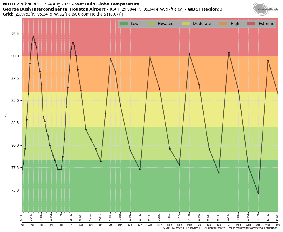
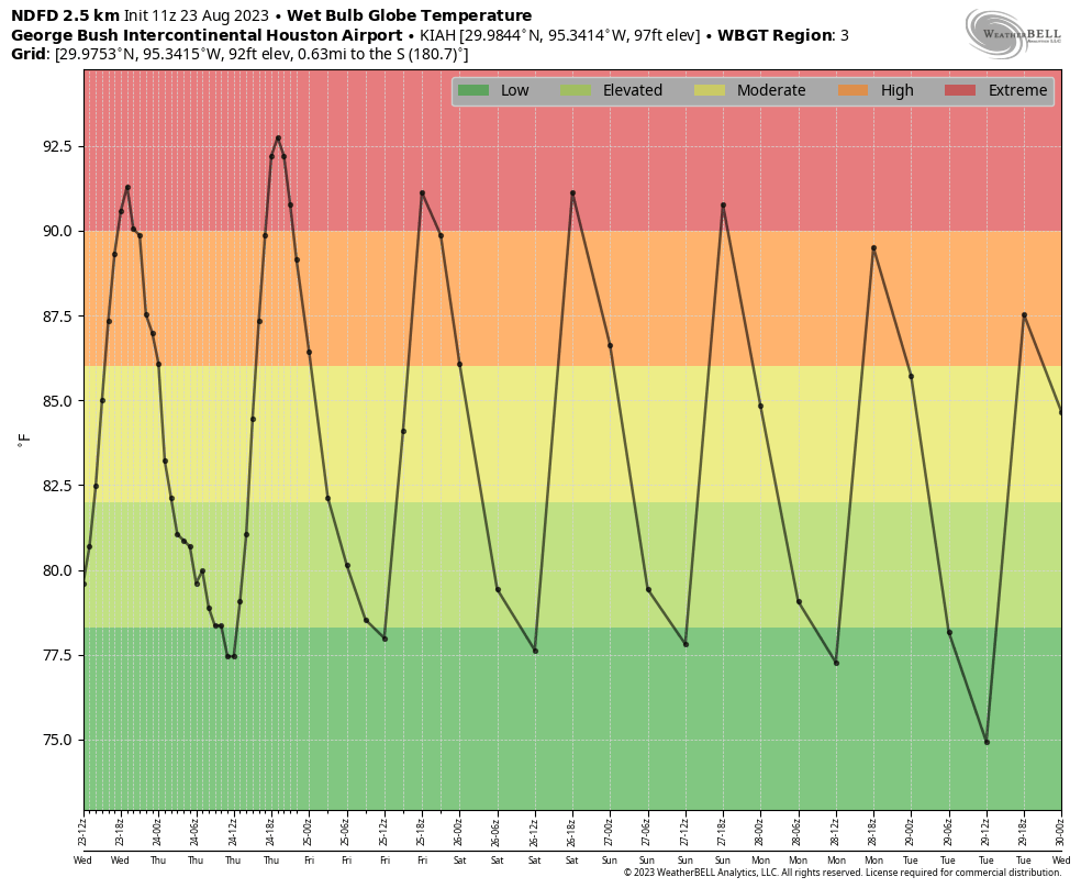
In terms of wet bulb globe temperatures, Thursday and Friday look to be excessively hot. (Weather Bell)
Thursday
Today is simply going to be blazing hot. Highs will range from near 100 degrees right along the coast to around 105 degrees or higher for inland locations such as Spring, College Station, and Kingwood. Skies will be sunny. With that said, some of our high-resolution modeling is indicating the possibility of an atmospheric disturbance moving southward later today, and this could produce scattered showers from mid-afternoon through the evening hours. I will freely admit that this forecast could be a total bust, especially with high pressure in place. But I think there’s at least some hope for a pleasant surprise with scattered showers this afternoon.
Friday
Another hot day, but temperatures should be a couple of degrees cooler than Thursday. We’ll again see sunny skies, but there’s also the possibility of a few late afternoon showers.
Saturday and Sunday
No changes in terms of temperatures. We’re looking at highs, generally, in the low 100s. Saturday is going to be sunny and hot. Sunday will as well, but at least there appears to be a slight possibility of some rain showers.
Next week
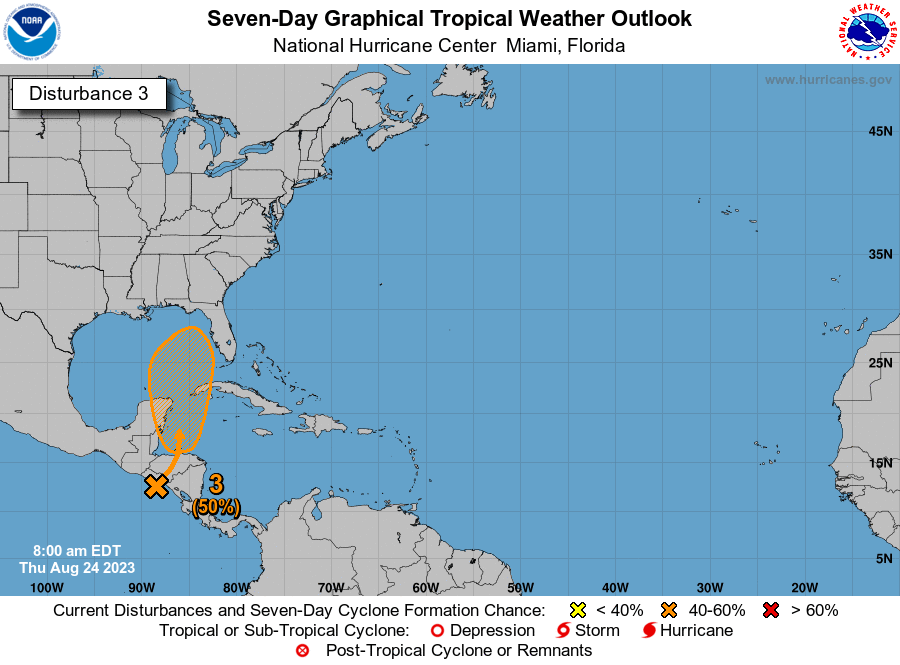
By early next week the dominant high pressure system will be retreating westward, and that at least opens up the possibility of some changes in our forecast. What form, precisely, those will take is yet unclear. At this point I’d guess highs will still be about 100 degrees, but we’ll see some daytime rain chances—whether those are 20 percent or 50 percent, I cannot say. There’s also a slight chance that a weak front pushes down into the region on Tuesday, which could knock humidity levels down a bit. But that is all very tentative. Our weather may also be influenced by a tropical system moving into the Eastern Gulf of Mexico.
Another tropical disturbance could be coming to the Gulf of Mexico early next week. (National Hurricane Center)
The tropics
For a few days now, the European model has been suggesting that a tropical system will emerge in the Western Caribbean Sea, related to the Central American Gyre, which is basically a broad monsoonal low-pressure system over Central America. Under this scenario a tropical low would then move north, into the Eastern Gulf of Mexico. Note there is far from universal support for this idea in the global models. In any case, such a system would likely remain away from Texas, and push drier air into our region from the northeast. For more detail on this system, check out our Atlantic hurricane coverage on The Eyewall.
Good morning. Before jumping into the forecast I want to briefly touch on Tuesday’s rainfall, as well as our brief reprieve from extremely hot weather. First, the rainfall. Parts of Galveston and Brazoria counties received a few tenths of an inch of rain from fading Tropical Storm Harold on Tuesday. These were welcome, if brief downpours of tropical rains. The vast majority of the region along and north of Interstate 10, however, received no precipitation whatsoever. The bottom line is that, as expected, our ugly and worsening drought continues. See the end of this post for a discussion of rain chances down the line.
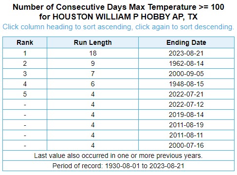
Additionally, the cloudy skies and breezy conditions—the strong easterly winds were part of Harold’s circulation—helped keep a lid on high temperatures. Houston’s Hobby Airport topped out at 97 degrees, and Bush Intercontinental peaked at 97 degrees as well. Both of these locations ended long streaks of days with recordings of 100 degrees or higher. Hobby’s streak was remarkable, 18 days, doubling its previous record of nine days. Hobby has collected meteorological data for nearly a century. Bush IAH ended its streak at 23 days, falling one day short of the city’s all-time record of 24 days, set during the torrid month of August 2011.
Streaks of 100-degree days at Hobby Airport. (NWS)
Unfortunately, we’re probably going to start new streaks at both locations today. Harold is gone, and extreme heat is back on the menu for a little while longer.
Wednesday
We’re right back to very hot weather today, with area-wide highs of about 100 degrees, high humidity, and mostly sunny skies. Winds will shift to come from the southeast at 5 to 10 mph. The key difference for the rest of this week is that we are going to see some weak atmospheric disturbances roll through the area. It’s going to be difficult for these to generate significant rainfall, given the sinking air associated with high pressure. However, it will not be impossible, and therefore each day should carry about a 20 percent chance of rain.
Thursday looks to be extremely hot. (Weather Bell)
Thursday
As high pressure moves almost directly overhead, this should be a very hot day, with highs generally in the low 100s across the area, away from the coast. Afternoon rain chances, again, look to be on the order of 20 percent.
Friday, Saturday, and Sunday
The forecast remains more or less the same, with highs of around 100 degrees, mostly sunny skies, and a puncher’s chance of some rain showers.
Based on wet bulb globe temperatures, things start to look a bit better by early next week. (Weather Bell)
Next week
This is where the forecast starts to get a little bit more interesting. The high pressure system that has dominated our weather for much of this summer looks to fade westward, and this should allow for a slight moderation of temperatures. We may also see some better rain chances by Tuesday or so of next week, but that’s far enough into the future I would not want to bet on anything. But I do have some modest hopes, and the end of August is on the horizon.
Space City Weather app
We’ve updated our app to address some bugs that readers have reported with old timestamps and odd temperatures. Our developer thinks he has worked through the problem, but if you’re still seeing issues, please email us at [email protected]. Thank you to everyone who reported problems in the last couple of weeks. If you haven’t downloaded our app, you can get it for free here for Apple, and here for Android.