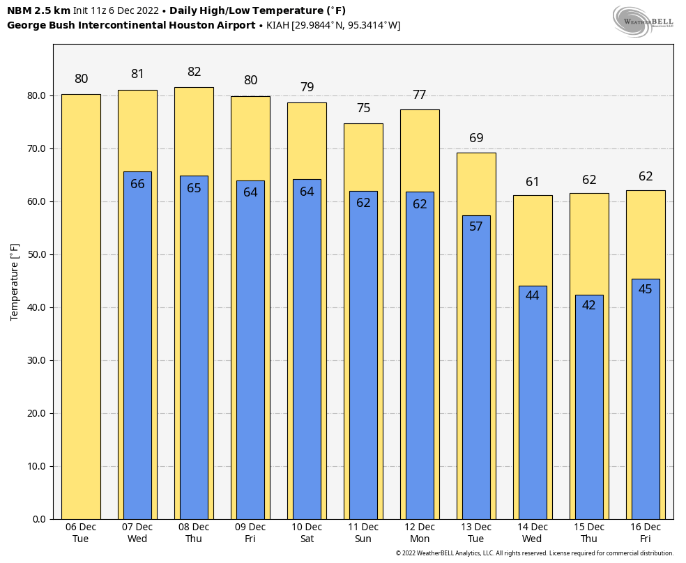
There is not a whole lot to say about our weather for the upcoming week in <checks notes> early December. High temperatures will be around 80 degrees for much of this week and weekend. More winter-like weather is coming with a definitive pattern shift, but that probably is a week away. So until then we’ll be singing Frosty the Air Conditioner Man rather than Frosty the Snowman.
Tuesday
The overall pattern today is the one we’re going to see for awhile, which is to say high pressure offshore and lower pressures over the central United States. This will drive an onshore flow that will keep our conditions warm and fairly humid, especially for December. Highs today will reach about 80 degrees or just above in the city of Houston, with warmer conditions possible inland, especially to the west in places like Katy. Look for partly sunny skies and light southerly winds. There is about a 10 percent chance of rain. Lows tonight will drop into the upper 60s.
This week, my friends, will not feel like December. (Weather Bell)
Wednesday
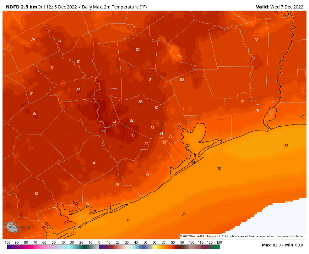
If anything, temperatures on Wednesday may be a degree or two warmer than Tuesday, with a mix of sunshine and clouds. Rain chances are perhaps 20 percent, but anything that falls will be light and probably briefly lived. Expect another warm night.
Thursday and Friday
Welp, I had hoped for some slight relief toward the end of the week as a front pushed into Houston, but it now appears that this weak front will wash out before pushing too far into the metro area. As a result, we can probably expect a pair of warm days with highs near 80 degrees, partly to mostly sunny skies, and perhaps a 20 percent chance of rain. Areas well inland may see some slightly cooler and drier air from the front.
Saturday and Sunday
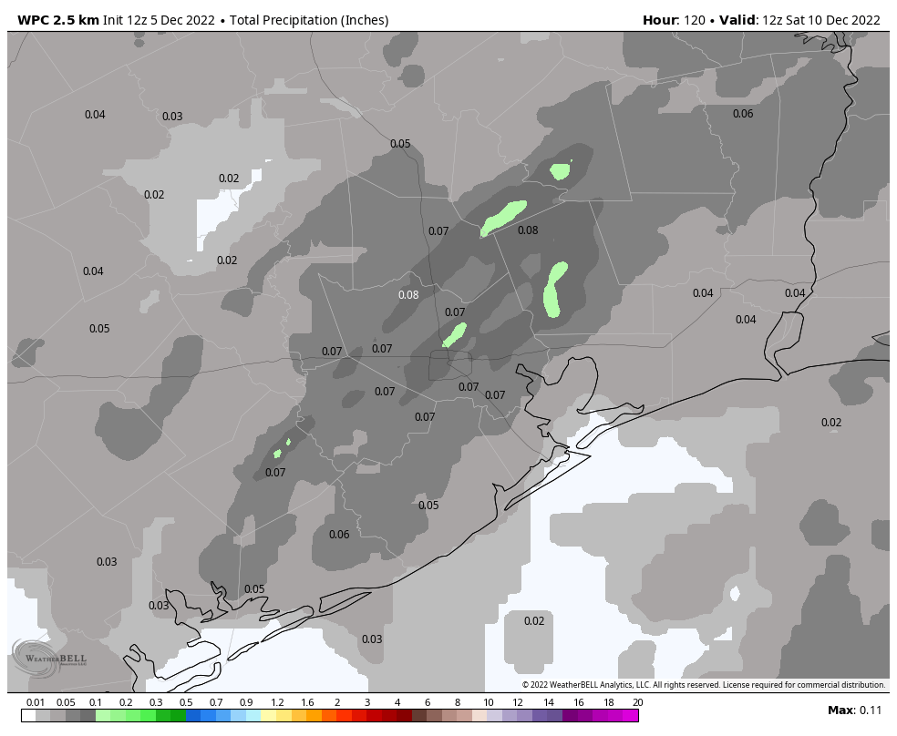
The weekend should see continued warm weather, with highs likely in the upper 70s, and partly to mostly sunny skies. Rain chances may be slightly higher, in the vicinity of 30 percent, as another front washes out over the area. This front may bring some moderately drier air to Houston, especially away from the coast. But it’s still not going to feel anything at all like December outside.
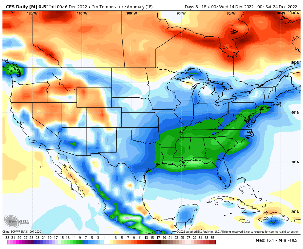
Seasonal modeling indicates a significant pattern change for the second half of December. This is a temperature anomaly forecast for Dec. 14 through Dec. 24. (Weather Bell)
Next week
We’re likely going to have to wait until Monday night or Tuesday for the next real front to barrel into Houston. However, when it does come, there is pretty good agreement in the global models that this front will mark the start of a pattern change for much of the United States, including Texas. The second half of December does look winter-like for our region, although it’s too early to have any confidence in details for Christmas Day.
Good morning. Temperatures are generally in the upper 60s across the Houston metro area, with nearly matching dewpoints. This is our new normal for awhile, as we are going to see substantially warmer than usual conditions for the next week, with high temperatures in the 70s to 80 degrees, and moderate nights. This anomalously warm weather will persist into the weekend, at which point a cold front should finally bring some relief.
Monday
Coastal areas are seeing patchy to dense sea fog this morning, which has reduced visibility to one-quarter mile or less for some areas. An advisory is in effect. This may persist until 8 or 9 am before lifting. Later today, skies should be partly to mostly sunny, with highs in the upper 70s. Winds will be out of the south at about 10 mph, with gusts up to 20 mph. There’s a slight chance of some light, misty rain this afternoon. Low temperatures tonight will be sticky, with lows unlikely to drop much below 70 degrees.
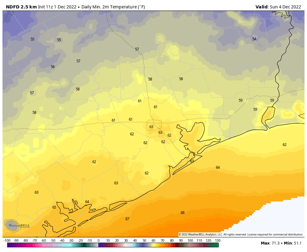
High temperatures on Wednesday will reach 80 degrees for some locations. (Weather Bell)
Tuesday and Wednesday
Our weather will continue to be dominated by a persistent southerly flow through the middle of the week. So we can expect days much like Monday, with a chance of fog, highs near 80 degrees, and a mix of clouds and sunshine. There’s a slight chance of light rain both days. Overnight lows will be around 70 degrees, with is far, far above the normal low this time of year, the upper 40s.
Thursday and Friday
It looks like a weak front will approach the area on Thursday, increasing the chance of some light rain to about 30 or 40 percent. The front should knock a bit of heat and humidity out of the forecast, but not too much. Lows may drop into the upper 50s for inland areas on Thursday night, but most of the Houston metro area will be in the 60s. Highs on Friday may be in the mid-70s, with partly to mostly sunny skies.
The rain accumulation forecast through Friday reflects the possibility of very light rainfall. (Weather Bell)
Saturday and Sunday
The aforementioned weak front will probably move back onshore as a warm front on Saturday, bringing with it a chance of rain showers. Highs on Saturday will probably reach the upper 70s, with partly sunny skies. Another, stronger, front seems likely to push through on Sunday or Sunday evening, and there may be some additional showers with its passage. So the forecast for Sunday, at this point, calls for about a 50 percent chance of rain with highs in the 70s.
Next week
The second front should knock highs down into the 60s for much of next week, with lows perhaps in the 50s or even 40s. It will, at least, start to feel more like the holiday season. The details on how cold, and for low long, are fuzzy. But winter should make something of a comeback.
Thursday saw clouds gradually take over our skies, a sign of the expected change that we’re beginning to feel this morning. Step outside, and it feels a bit different than 24 hours ago.
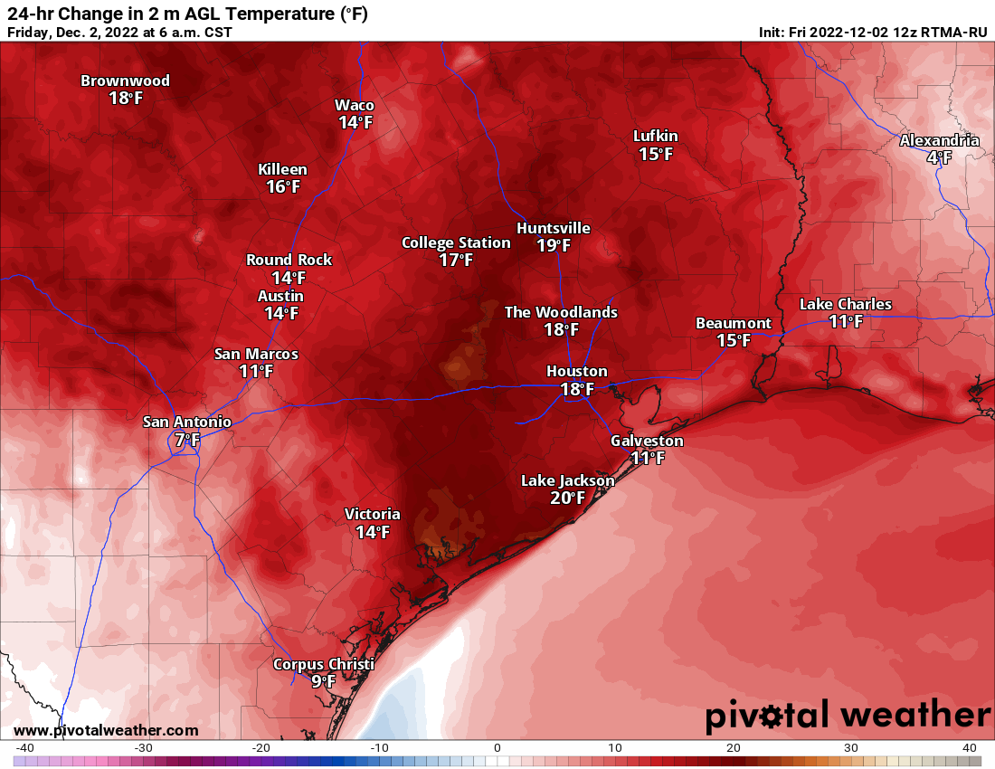
Temperatures are running nearly 20 degrees warmer this morning than they were at the same time on Thursday. (Pivotal Weather)
In fact, most parts of the Houston area are almost 20 degrees warmer than they were yesterday at the same time. This heralds our movement into a milder, more humid pattern that’s likely to stay with us with minimal interruption through next weekend.
Below today’s forecast, I’ve got the latest installment of the SCW Book Club, with some comments on The Worst Hard Time, by Timothy Egan.
Today
As the warm front delivering us the change in weather pushes north today, we can expect a few things to happen. First, a few showers or pockets of light rain and drizzle will be possible amid the cloud cover today. We already have a little of that this morning. Second, areas of fog are likely to begin forming along the coast by later this afternoon and evening. Watch for dense fog tonight in Galveston and elsewhere near the bays and coast. We’ll see temperatures soar into the mid-70s or better today.
Saturday & Sunday
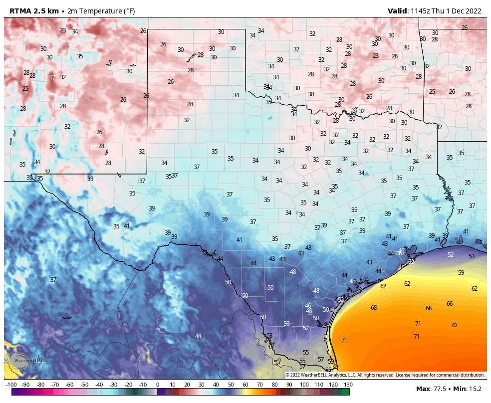
The forecast gets a little challenging tomorrow. A cool front is going to push into far northwest parts of the region, and that means there will be some temperatures discrepancies. Places like Huntsville or College Station through Navasota could see temps fall from near 70 into the low-60s or even 50s later on Saturday afternoon. Houston and points south and east should not see the front until later Saturday, so expect highs well into the 70s again. Temperatures will drop into the 50s in parts of the area, while coastal areas stay in the 60s Saturday night, all of this contingent on exactly where the front gets before shifting into reverse. Basically, it might not be a bad plan to have a light jacket handy in case that front is a little faster than we expect, particularly if your plans will be north of I-10 on Saturday.
As a cold front toys with areas north of I-10 on Saturday afternoon, we could see highs only get into the upper-60s in some spots, before dropping 5 to 8 degrees or so. That front should arrive in the Houston area late in the afternoon or evening, after temperatures get well into the 70s. (Pivotal Weather)
Other than clouds, fog will be an issue most of Saturday along the coast and bays and just inland from there. December is the second most likely month of the year for dense fog in the Houston area (behind only February). So, it’s that time of year. A few showers will be possible on Saturday as this front toys with us.
On Sunday, that front will start to lift back north and out of the area as a warm front, bringing back warm temperatures and humidity. We will have upper-60s or perhaps 70s again with clouds, patchy fog near the coast, and maybe a little sun. Maybe.
Monday through Wednesday
By Monday, we’ll be well back into a soupy air mass with high humidity and warm temperatures. Look for highs near 80 with clouds and a little sun, as well as a little coastal fog. Tuesday looks to be a repeat, if not a degree or two warmer. Wednesday? You guessed it; more of the same. All three days will have lows in the upper-60s to low-70s. They’ll also carry low-end shower chances, as the warm weather should keep the atmosphere fairly well “capped” I think, inhibiting showers and storms in our area.
Late next week
At this point, Thursday and Friday look fairly similar to the front part of the week with upper-70s to low-80s, clouds, and a slight shower chance. Areas of fog may be more widespread later in the week, however. As of now, let’s pencil in the next cold front for Saturday. Could be a bit faster or slower. This front may usher in a little bit of a lengthier cool spell for the week of the 12th, so for those of you who don’t like seeing 80s in December, there is hope. We’ll have more on that next week.
SCW book club
Back in spring, we started a concept called “SCW Book Club.” For those that follow me (Matt) on Twitter, you know I read a lot. Or I try to. With two toddlers that is becoming increasingly challenging! The premise of SCW book club was that anytime a weather or disaster-related item of interest entered my reading stack, I’d share some thoughts on it with all of you. In March, I reviewed Rachel Kimbro’s excellent In Too Deep about why people rebuild after repeated flooding. I said I’d get to The Worst Hard Time, by Timothy Egan, a book about the Dust Bowl. I did, but I did not get to it “later this spring.” Whatever the case, I finally finished it last weekend! And I can truly say it’s a must-read.
The Worst Hard Time is your passport to life in the Dust Bowl.
It was published in the mid-2000s and won the 2006 National Book Award for non-fiction. I approach books like this cautiously because I know they’re well-regarded for a reason. For some reason, The Johnstown Flood, by David McCullough, another of those seminal disaster narratives did not hook me as much as I had hoped. It was fascinating and enjoyable, but something about it left me wanting (I have three books by McCullough on my nightstand at present though, so I will definitely be giving him another go in ’23). The Worst Hard Time lived up to the hype.
The book does such a good job telling the story of the Dust Bowl through the lens of various residents of the High Plains. Egan’s writing captures you immediately. There were moments where it was tough to put the book down. Some books about disasters can be academic in a sense; this is not that at all.
“The land around them was tossed about and dusted over, as lifeless as the pockmarked fields of France after years of trench warfare.”
For someone like me, this book was nearly perfect. It covers the history of a major American event, a weather-influenced event. Egan went into detail about how FDR planned to help solve the issue, so it included the “politics” of the day as well. Ultimately, the story of the Dust Bowl is so terribly nuanced that even for someone that knows a good bit about what happened, it can surprise you. Between learning how many people were sold a lie, then doing what they had to do to survive and destroying the land in the process, the Dust Bowl was even less a truly “natural” disaster than I ever believed.
If you want to truly understand the Dust Bowl and what people lived through in that part of the country during that time, this is your book. If you’ve read the book, please drop some comments and share your thoughts below. I’ll be keeping tabs on them.
The next weather book I am going to get to is a book called F5: Devastation, Survival, and the Most Violent Tornado Outbreak of the 20th Century, by Mark Levine (not to be confused with political commentator Mark Levin). This book recounts the April 1974 “Super Outbreak” of tornadoes that swept across a large part of the Eastern U.S. This book is tough to find, so if you’re fortunate to grab a copy and want to read it too, feel free. I actually stumbled onto my copy at Kaboom Books in Woodland Heights, which is a delight if you ever have time.
After that, I intend to read a book entitled Air Apparent, by Mark Monmonier which traces the history of the weather map. I imagine many of our readers might enjoy this one. This is also somewhat difficult to track down, but some used copies are available over on bookshop.org. I’m looking forward to this one. Look for something on that after the holidays.
Hello, winter. It’s easy to pinpoint the moment at which the most recent front barreled into Houston. At 3:15 am on Wednesday morning it was 70 degrees at Bush Intercontinental Airport. The dewpoint was 66 degrees—which is rather sticky for late November—which made for a relative humidity of 88 percent. Then winds started to gust out of the north at 25 to 30 mph. An hour later the temperature had dropped into the 50s, with the dewpoint in the 40s. This morning the low bottomed out in the upper 30s for Bush, and other inland areas. This is proper winter weather for Houston.
Goodbye, winter. As quickly as the front moved in on Wednesday, it will start to head for the exits today. Winds are already turning easterly and this will moderate temperatures, setting the stage for a warm weekend. It looks like we’re going to remain anomalously warm for awhile, but there is some hope on the horizon for those who like a bit of colder air with their holiday season. The overall pattern will start to favor an influx of significantly colder air in about 7 to 10 days time.
The first day of December is starting off cold for Texas. (Weather Bell)
Thursday
This morning is cold, with inland areas seeing lows in the upper 30s, and much of the rest of the region in the low 40s. Skies are clear, but with those easterly winds today we’re going to see clouds start to develop. Highs across the area should reach about 60 degrees, or slightly higher. With the warmer flow, expect lows tonight to only drop into the mid-50s in Houston, with cooler conditions further inland. There is a very slight chance of light rain after midnight.
Friday
This will be a warmer day, with highs in the upper 70s and mostly cloudy skies. We’ll again see a slight chance, perhaps about 20 percent, of some light, misty showers. Winds will be light, generally out of the southeast. Lows Friday night will struggle to drop below 70 degrees in Houston, and with continued light winds fog is a definite possibility on Friday night going into Saturday morning.
Saturday and Sunday
The weekend will be the opposite of clear and cold. The forecast is complicated by the arrival of a weak front that may move into the Houston metro area on Saturday and then stall out. For inland areas, this may bring a bit of cooler and drier air on Saturday night. Anyway, my general expection is for a mostly cloudy day on Saturday, with highs in the upper 70s and perhaps a 30 percent chance of the aforementioned light, misty rainfall. Lows Saturday night will depend on how far you live from the coast, but I’d expect them to drop into the low- to mid-60s in Houston. Sunday will be similar to Saturday, with mostly cloudy skies and highs in the mid- to upper-70s. We can’t entirely rule out a few scattered, light showers.
Inland areas may briefly see some cooler and drier air on Saturday night and Sunday morning. (Weather Bell)
Next week
That weak front that stalled out over Houston on Saturday will move back inland as a warm front on Sunday, and that will set us up for a warm start to next week, with some partly sunny days and highs of around 80 degrees. The tea leaves become more difficult to read after this point, as it’s not clear whether a mid-week front will make it all the way to the coast. If it does not—and this is the scenario I would lean toward at this moment—then the second half of next week likely remains warmish and humid, with highs in the upper 70s. We’ll see. Although it’s a long ways off, the models do seem pretty confident in much colder air moving into Houston by around December 10, and the overall atmospheric pattern supports such a scenario. But I’m not betting the mortgage on a 10-day forecast, and I recommend you not do so, either.