Good morning. There’s not much good to say about our weather for the next several days, outside of the fact that at least we won’t see flooding or the winds howling. However, after three or four really hot days of triple-digit temperatures, I do think we’ll see a slight downturn in highs, and an uptick in rain chances. The effect is likely to be subtle, but any relief is better than no relief, right?
Tuesday
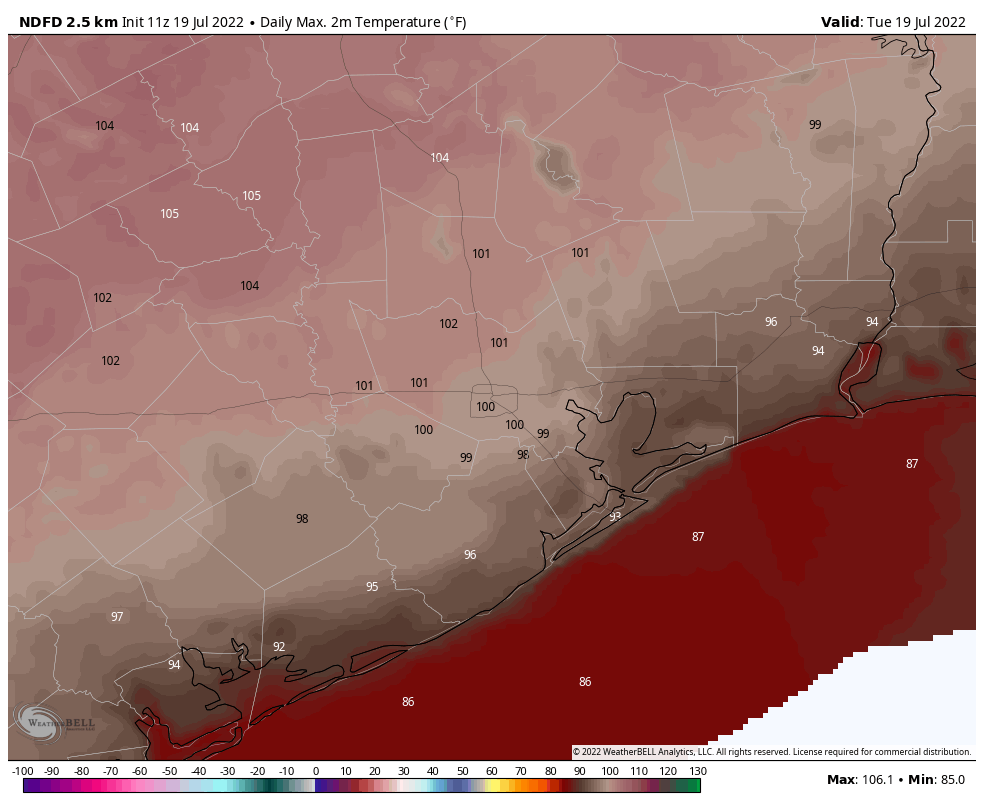
Monday’s high temperature reached 100 degrees at Bush Intercontinental Airport, and we can probably expect today to be a carbon copy with mostly sunny skies. Winds will be out of the south, at 10 mph or so, with gusts up to 15 or 20 mph. Lows tonight probably won’t drop below 80 degrees for most of the region.
Tuesday’s high temperature forecast. (Weather Bell)
Wednesday and Thursday
It looks like the heat will peak on these days, with highs ranging from 100 to the low 100s for much of the area away from the coast. Expect sunny skies and southern winds. You should know the drill by now.
Friday, Saturday, and Sunday
It’s still going to be hot, but highs at some point should start to drop back into the upper 90s. We’ll also see a somewhat more disturbed atmosphere that should allow for the development of at least some isolated showers and thunderstorms. Expect mostly sunny skies.
Slight relief is better than no relief, right? (Weather Bell)
Next week
Overall, the pattern won’t change a whole lot. But I think we’ll see highs in the mid- to upper-90s, instead of around 100 degrees. And rain chances will continue to be non-zero, but at this point it’s difficult to say whether we’re talking about 10 to 20 percent chances each day, or the more hopeful 30 to 40 percent.
Good morning. I wanted nothing more than to start this week by writing a hopeful post about Houston’s forthcoming weather—to say something about cooler weather ahead, more moderate nights, or a few days of steady rainfall and cloudy days. Alas, this is a reality-based site, and I’m sorry to say the rest of July looks very sunny, very hot, and mostly rain free.
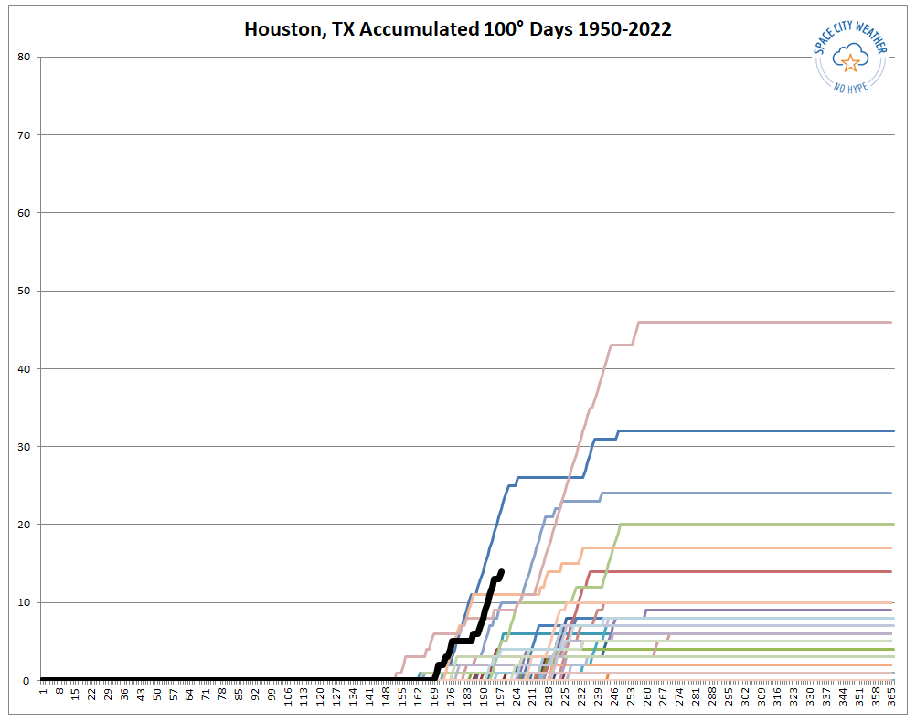
Before jumping into the forecast, dreadful though it may be, I wanted to provide a situational update on our 100 degree days this year. These are officially recorded at Bush Intercontinental Airport, which is the city’s official monitoring station. Through Sunday, the city has now recorded 14 such days, which places this year second only to 1980 in terms of accumulation through July 17. Matt has been tracking these dates, and prepared the line chart below to show how this year (black line) compares to to most summers. Of note are years 1980 (Blue) and 2011 (pink).
Accumulation of 100-degree days, by year, in Houston since 1950. (Space City Weather)
Monday
High pressure is back, and it will be the dominant factor in our weather for the week ahead. This means mostly sunny skies for today, with highs near or above 100 degrees for inland areas, with highs in the low- to mid-90s near the coast. Winds will be light, out of the south or southwest at 5 to 10 mph. Lows will be sultry, only dropping to about 80 degrees in Houston. Rain chances are 10 percent or less, due to a capping inversion that is helping to prevent air at the surface from rising.
Tuesday
Rinse and repeat, although there will be precious little rinsing due to a lack of rain.
Wednesday and Thursday
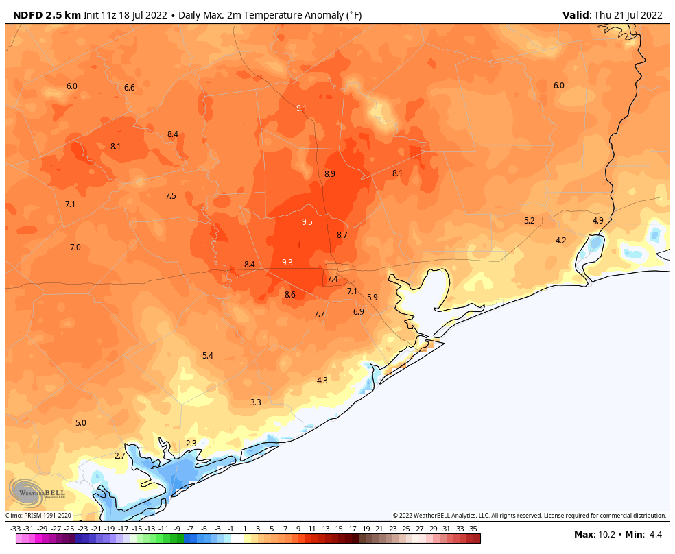
Both of these days will be sunny, and perhaps a degree or two warmer as the high really takes hold.
High temperatures on Thursday are forecast to be 5 to 10 degrees above normal for most of the region. (Weather Bell)
Friday
Some sort of weak disturbance may attempt to pass over the area toward the end of the week, and this could bump up our rain chances to about 20 or possibly even 30 percent. It ain’t much, but it’s probably the best we’ll see this week.
Saturday and Sunday
These should be mostly sunny days, with highs of around 100 degrees. Rain chances at this point don’t look to be zero, but they are less than 20 percent.
Next week
If you’re looking to the extended forecast with some hope of a pattern change, I would say two things. First of all, congratulations on being an optimist. The worlds needs more of you. The second thing I would say is to remind you that August begins in 13 days.
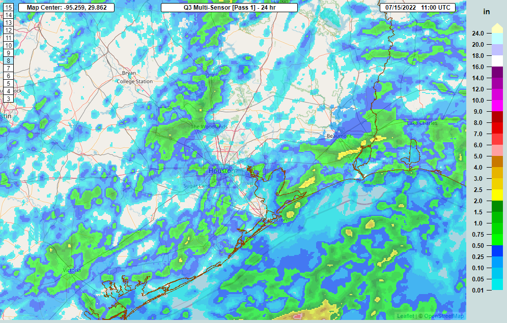
A number of folks across the area saw rain yesterday, which was great.
A good chunk of the area saw rain yesterday, with just a couple spots seeing close to 2 inches. (NOAA NSSL)
We need what we can get right now, coming off our hottest 5 consecutive days on record Saturday-Wednesday. I’ve seen folks say that 1980 and 2011 were worse. By July 14th of those years, we had amassed 20 100° days in 1980 and 11 in 2011. So far in 2022, we’ve managed 13 of them. So yes, 1980 was hotter — during the day. At night is where things have changed. 1980 averaged 75.6 degrees for July nighttime lows. So far this month, we’re averaging 78.1 degrees for nighttime lows. As such, this July is on pace to be our hottest. Warmer nighttime lows are a health hazard, extending the heat.
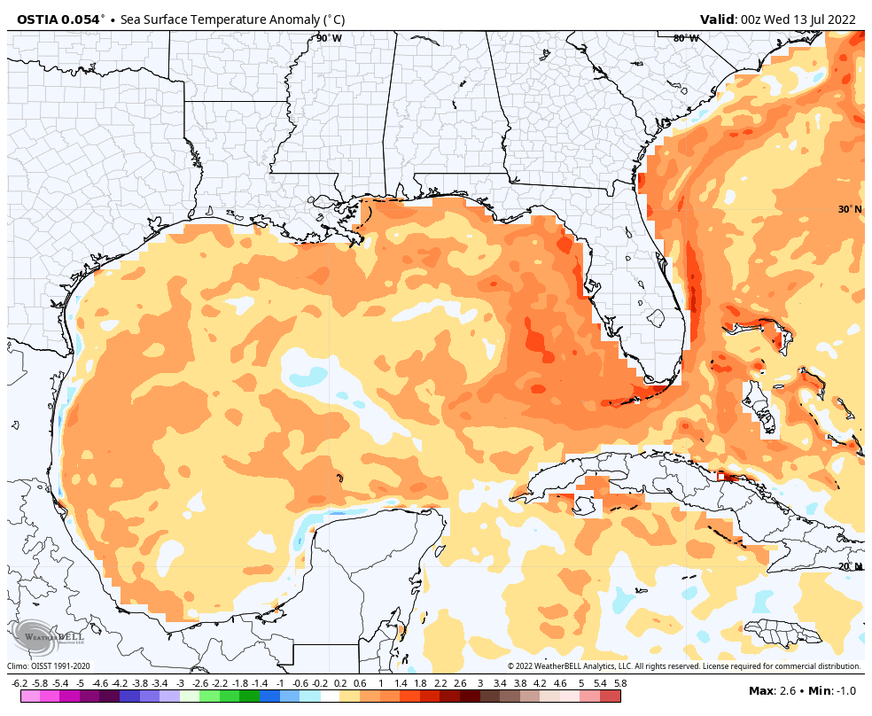
A warmer than normal Gulf of Mexico is likely contributing to our warming nighttimes.
Between 2010 and this year, Houston has set or tied almost 150 daily records for warm nighttime lows, sometimes multiple times over the period. Galveston has set or tied 189 of them. A frequently warmer than normal Gulf (including this year as shown above), climate change, and land-use change (urban sprawl) are all contributing factors to making heat waves somewhat worse than they were in the past. So this isn’t the periodic hot summer. It’s the slightly more frequent hot summer with an extra spoonful of sprinkles on top. We see no real end in sight to our current hot weather.
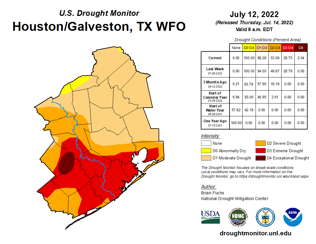
Drought has worsened as well.
Drought is now classified as “exceptional” for a portion of Wharton, Colorado, and Austin Counties. (Drought Monitor)
The entire Houston area is officially in drought. The southern half of the area remains in extreme drought, the second worst category, and this week saw the addition of some exceptional drought, the worst category, west of Houston. Notably in 2011 the entire area was in exceptional drought at this point. With August still ahead of us, I am not especially thrilled with where we presently stand.
Friday
After yesterday saw some rain, today should see some more. We are starting with just a couple showers here and there, mainly south of I-10. Today’s focus should be south of Houston. That isn’t to say that if you live north of I-10 you won’t see anything, but the odds are highest to the south, the part of our area most in need right now. Look for coverage of storms, especially south of the city to become more numerous as the afternoon develops. Locally heavy rain is possible today, perhaps up to 2 or 3 inches in the most persistent storms, so do keep an eye out for localized, brief street flooding in those areas hit hardest.
With rain showers and some clouds, look for temperatures ranging from the upper-80s to mid-90s today.
Weekend
Look for rain chances to fall back a good bit to a requisite 10 to maybe 20 percent chance on Saturday and Sunday. High temperatures, while hot, should stay sub-100 for most of us. I would expect lows in the 70s to near 80 and highs in the upper-90s both days.
Next week
We could see a slight uptick in shower chances on Monday, but I wouldn’t get my hopes up. Otherwise, high pressure will begin to re-flex itself overhead. This means heat, humidity, and just minor rain chances on any given day. Look for 100s to populate the forecast again, along with frequent heat advisories.
I was taught that if you’ve got nothing good to say, don’t say anything at all. (Weather Bell)
Overnight lows will bounce between the upper-70s and low-80s. In other words, more of the same. There’s no meaningful sign of change to this pattern at this time.
Tropics
If you want good news, the tropics are quiet right now, and they look to stay that way for awhile. We’ll update things again next Tuesday. It’s tempting to wish for a tropical storm or hurricane to break our misery, but this feels very much like a case of be careful what you wish for. Here’s hoping however things go over the next few months, they go gently.
Good morning. We’ve seen a healthy line of thunderstorms move through coastal areas this morning, including a pretty good soaking for the city of Galveston. As I write this the rain-cooled temperature is 77 degrees on the island. According to the National Weather Service, this is the first time the temperature there has dropped below 83 degrees, since July 1. I’m hopeful that other parts of the metro Houston area will see some welcome showers today and on Friday before heat and high pressure return this weekend.
Thursday
Skies will be partly sunny today as atmospheric moisture levels increase, and high pressure remains just far enough to our northwest to allow clouds to form. Showers and thunderstorms will become increasingly likely this afternoon, with storms moving from northeast to southwest. Local temperatures will depend a lot on the extent of this cloud cover later today, and whether you see showers this afternoon and evening. Overall, I expect areas south of 1-10 to stay in the low- to mid-90s, with inland areas likely seeing the upper 90s, and some locations such as College Station probably pushing to 100 degrees.
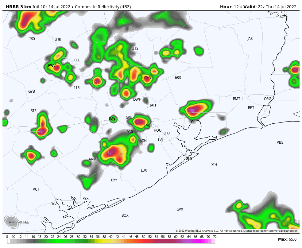
HRRR model radar forecast for 5 pm CT on Thursday. This will not reflect reality, but gives some sense of the kind of pattern to expect. (Weather Bell)
Rain chances are about 40 percent, and these showers will be hit or miss, with briefly intense rains possible and straight-line winds within thunderstorms. Storm chances will slacken overnight. Winds will be light, mostly out of the southeast.
Friday
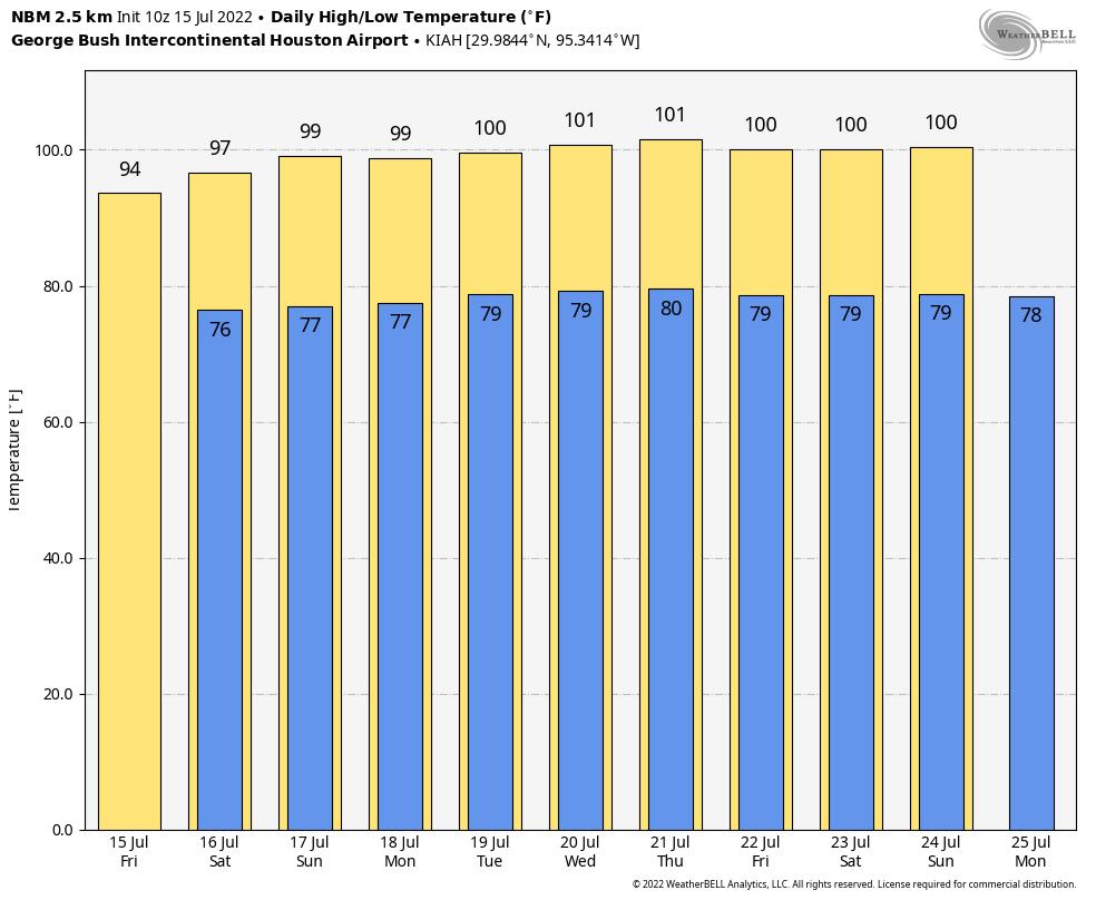
I expect Friday to be similar to Thursday, albeit with probably the better chance of rain closer to the coast. This day probably is our region’s best chance to see a high temperature of 95 degrees or lower since July 1, and also probably our best chance of doing so for at least the next week or 10 days.
Saturday and Sunday
The weekend should see a return to high temperatures in the upper 90s for much of the region, with far inland areas possibly hitting 100 degrees. These days will be mostly sunny, although we probably will have about a 20 percent chance of an afternoon shower.
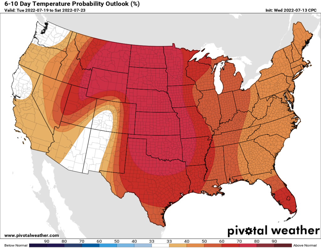
Next week looks extremely warm for Texas and much of the rest of the country. (Pivotal Weather)
Next week
Unfortunately it appears as though high pressure will continue to build back over the area next week, pushing area-wide highs toward 100 degrees again, and rain chances below 20 percent each day. If you’re wondering when this pattern will break, I’m not sure I have a great answer. Instead, I have a depressing one—we still have our warmest month to come, August, when these ridges are often at their thickest. I hope you see some precipitation today.