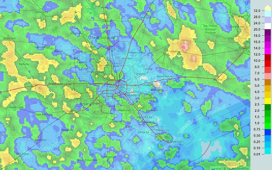
Good morning. After a wet weekend for some—a really wet weekend for the Liberty area, with more than 8 inches of rain—the greater Houston region will see an ongoing wet pattern for much of this week. However, these rains should be manageable for the most part, so we don’t anticipate significant flooding issues.
Rain accumulations during the July 4th weekend. (NOAA)
Monday
Today should be similar to the July Fourth holiday, with showers developing this morning and spreading inland. Accumulations will vary widely, with some areas seeing little rain, and others picking up a couple of inches. Areas most likely to see heavy rains are to the southwest of Houston, particularly the Matagorda Bay region. Skies should otherwise be partly sunny, with highs near 90 degrees, and light southeast winds. Rain chances will slacken overnight, but not go away entirely.
Tuesday and Wednesday
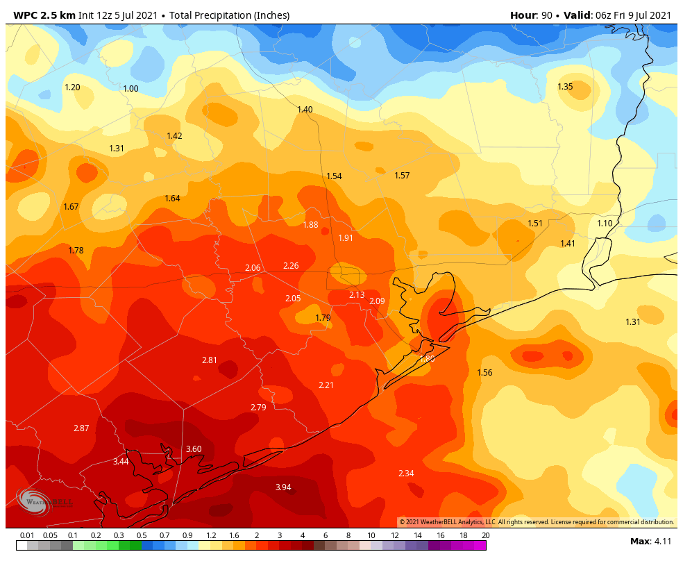
With high moisture levels in place, and an absence of high pressure, this fairly wet pattern should continue with additional chances of showers, thunderstorms, and briefly heavy rain. All of this will combine to limit high temperatures to the upper 80s to 90 degrees. In terms of accumulations, most of Houston should see 1 to 3 inches of rain through the middle of the week, with higher totals possible closer to the coast.
NOAA rain accumulation forecast for now through Thursday. (Weather Bell)
Thursday and Friday
Rain chances will begin to decrease on Thursday, and will probably drop back to about 20 or 30 percent by Friday. This should allow for a little more sunshine, and if sunny skies align with afternoon hours, some areas may see highs in the low 90s. Otherwise, much of the area may remain capped at about 90 degrees.
Saturday and Sunday
So is another soggy weekend in store? Although the forecast is not yet locked in, I don’t think we’re going to see full on rainfall this weekend, but each afternoon should see a decent chance of showers with at least partly cloudy skies. Highs will be around 90 degrees, with super high humidity.
Tropics
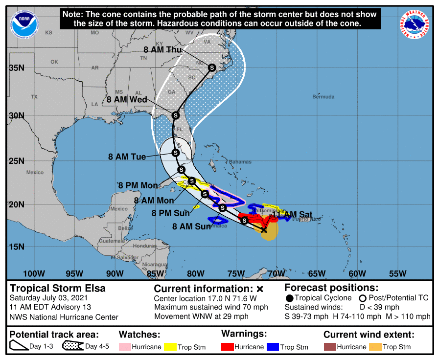
Tropical Storm Elsa will move across Cuba today, and then track up the western coast of Florida before making landfall, likely some time on Wednesday. It is not expected to do so as a hurricane, due to wind shear and its interaction with Cuba. The main threat, as usual from tropical storms, is rainfall. But so far the forecast does not look too extreme as these things go.
NOAA rain accumulation forecast for now through Friday morning. (Weather Bell)
I hope everyone is enjoying the Fourth of July weekend. We’re posting a brief update this morning to call attention to the potential for storms across much of Houston today, and say confidence is finally increasing about the track of Tropical Storm Elsa.
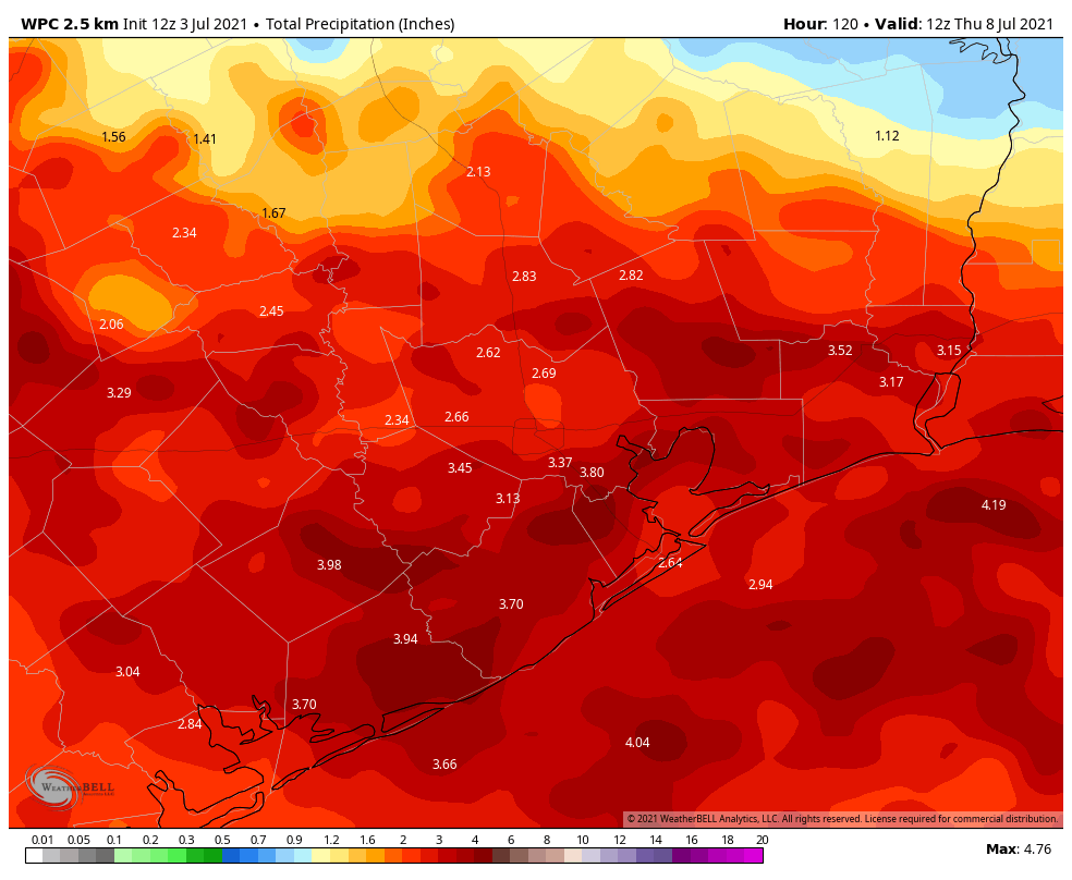
The good news is that, while we expect a fairly wet pattern over the next several days, our concerns about the potential for serious flooding are diminishing. Generally, most of the region should see between 2 and 4 inches between now and Thursday morning, with higher isolated amounts. While this will surely make for a soggy week, it should only produce scattered and sporadic street flooding.
NOAA rain accumulation forecast for now through Wednesday. (Weather Bell)
With that said, if you have outdoor plans for the July Fourth holiday weekend you’ll definitely need to keep an eye on the radar, and have a backup. As of 10am CT on Saturday morning, storms are already firing up north of Interstate 10, and these should drop down to the coast later this morning and into the afternoon hours. A good chance of storms will persist through at least the early evening hours. Please do seek shelter during thunderstorms, as we expect to see a fair amount of lightning today. Conditions should be similar on Sunday, although we have some hope that most areas will see rains ending before fireworks shows begin. This rainy, cloudy pattern should persist through about Wednesday.
In the tropics, Elsa has weakened overnight as it has zipped westward across the northern Caribbean Sea. The global models are starting to come into better agreement, and confidence is now fairly high that Elsa will move across Cuba on Sunday, and approach the Florida Keys on Monday. After this time there remains some uncertainty, but generally the storm should track up the western coast of Florida, and may bring heavy rains to the state early next week.
Saturday morning track for Tropical Storm Elsa. (National Hurricane Center)
As for intensity, Elsa is now a high-end tropical storm, with maximum sustained winds of 70 mph. Maybe the cold never bothered Elsa anyway, but wind shear has been hampering the storm’s organization overnight, and as it faces additional shear and begins to interact with Cuba, it should weaken further. Elsa’s rapid movement to the west-northwest is not helping either, but the storm should begin to slow down fairly soon. The official forecast has Elsa approaching Florida as a strong tropical storm by around Tuesday of next week, and it would not surprise me if the system is weaker.
Well, I was hopeful that maybe we could identify a period over the next several days that didn’t look unsettled. While it isn’t going to rain everywhere the entire weekend, the chance of rain is going to be higher than usual everywhere from tonight through Tuesday or Wednesday of next week. We will walk you through things as best we can today, and we’ll conclude our Friday post with an update on Tropical Storm Elsa.
How much rain through next week?
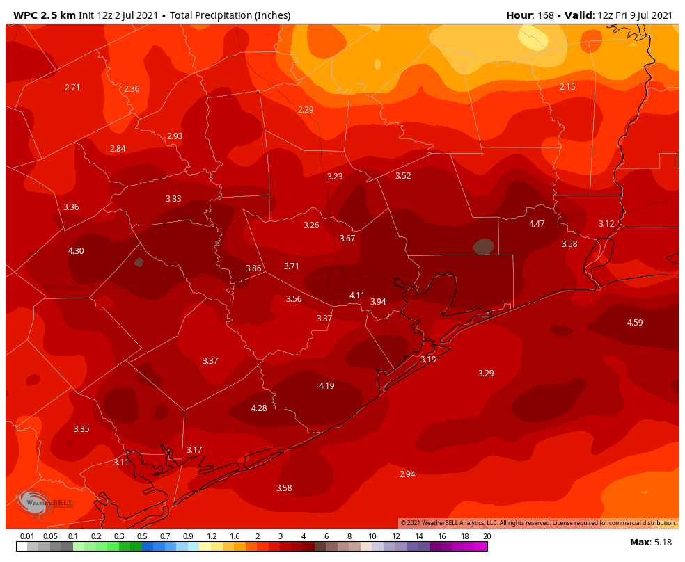
We’ll start off today’s post by addressing the question most people probably have: How much rain are we expecting, and will it flood? Rainfall totals are going to vary widely from location to location, but we’re confident that most places should 2 to 4 inches through Wednesday. That said, given significant amounts of atmospheric moisture (high precipitable water, or PWATs), any storms will be capable of producing 1 to 3 inch per hour rainfall rates. So it’s pretty obvious that some locations will see a good bit more than 4 inches over the coming days. Where exactly those locations are is to be determined.
Average rainfall over the next week should tally up to 2 to 4 inches, but there will be some neighborhoods that see considerably more than that. (NOAA via Weather Bell)
But as you can see from the map above, the current bullseye is just east of Houston. For those curious, the European model has its bullseye over the Sabine River, and the GFS does not really have a bullseye. But most models are in good agreement with this forecast above. You can expect a good bit of rain in the coming days.
Will it flood? This question is somewhat thornier. At this point we don’t expect significant flooding, but the reality is that we can’t rule out things getting a little dicey in spots at times. Even though there will likely be street flooding in spots at times, we are not yet going to trigger the Space City Weather Flood Scale. I do think at some point between now and Wednesday we are going to have to give in with a Stage 1 or 2 type event possible. Things can change, so stay with us through the holiday weekend, and make sure you have downloaded our app!
Today
Friday is going to start off fine. Look for sunshine and a few clouds. Today will probably be pretty hot, with highs in the mid-90s likely. I wouldn’t expect much worse than a couple hit or miss showers through 3 PM at this point. After 3 PM, a cold front begins to sag south into northern parts of the area, and we should see more organized storms break out along or north of Highway 105, dropping into Hempstead, Magnolia, The Woodlands, and Liberty this evening.
Tonight & Saturday
Those storms will continue pressing south after dark, reaching I-10 around or just before midnight, although they could weaken some. A few additional scattered storms will be possible overnight.
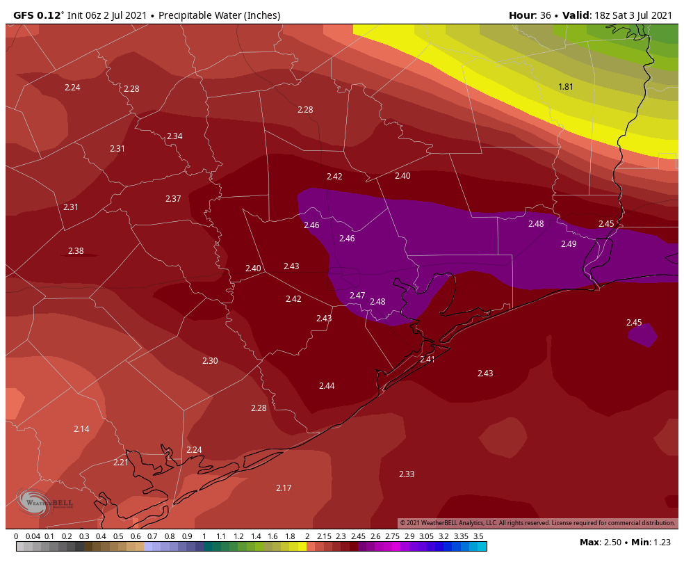
On Saturday, we get a surge of moisture (near-record PWATs for the date) that should allow for numerous showers and storms to break out across the region. I would expect a bit of atmospheric “bumper cars” to ensue tomorrow as boundaries collide, popping off new storms across the area in a chain reaction of sorts.
The amount of moisture available in the atmosphere (or PWAT) will be near record levels this weekend, meaning heavy rain is likely at times. (Weather Bell)
Showers could push or focus south of Houston tomorrow late day or evening.
Temperatures will be held down with clouds and rain. Look for lows in the 70s and highs in the mid-80s.
Sunday
Expect numerous showers and thunderstorms throughout Independence Day, with locally heavy rain possible. Highs will be in the 80s.
What to do about fireworks displays? Well, I wouldn’t be cancelling anything just yet. We are certainly talking up a wet weekend here, and the cancellation option is a very plausible one in some places. That said, there is a good chance that some parts of the area will be just fine for fireworks displays, albeit with some soggy ground to watch from. That decision should be as close to a game time one as possible.
Monday & Tuesday
It’s a bit of a tough call as to which day from Saturday through Wednesday has the best chance for the heaviest rain, but if I were a betting man, I might lay a few chips on Monday or Tuesday. We get a boost in moisture on those days, especially Tuesday and some pretty vigorous upper level support for rain too. Not everyone will see their heaviest rain early next week, but I think some people will, and this is where I would begin to perhaps be more mindful of flash flooding risks.
High temperatures will be held down here. Look for mid-80s at best (probably low-80s or even cooler in spots) for highs and 70s for lows.
Wednesday & Thursday
For the middle of next week, we currently expect to see things begin to wind down a bit. Expect scattered thunderstorms on Wednesday, but we are hopeful that the coverage will be noticeably less than it was on Monday and Tuesday. By Thursday, much will depend on what Tropical Storm Elsa does, but assuming it stays well east of us as forecast, we would probably just see sun, clouds, some isolated to scattered storms (unrelated to Elsa) and slightly warmer temperatures. We’ll see. But it appears that the pattern may begin to change back to a more typical summer one by late next week.
Tropical Storm Elsa
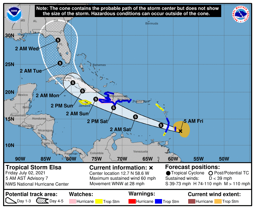
(Editor’s Note: Elsa was upgraded to a hurricane immediately after publication) Elsa did some work overnight getting better organized as it approaches Barbados and the southern Leeward Islands today. Max winds are now 60 mph, and although the National Hurricane Center forecast currently falls just short of Elsa becoming the season’s first hurricane, there is some chance it could attain that intensity.
Elsa could become a hurricane before it has to deal with land interaction in the Caribbean. (NOAA)
The forecast right now is officially comfortably east of our area, with a focus on Florida by Wednesday or Thursday of next week. There is still a very wide spread of options available to Elsa beyond day 3 or so, meaning that folks from Central Louisiana through the Bahamas, including all of Florida should still be monitoring Elsa’s progress closely. We continue to think this won’t be a direct issue for Texas, but we will monitor its progress and any track forecast changes through the weekend anyway.
Well, Houston, we’ve made it to July. Historically, the next two months are the hottest of the year. And we’ll certainly be in the 90s the next couple of days. But our bigger concern in the forecast period will be triggered by a cold front of all things, which won’t bring cold air but will initiate a wet period beginning Friday night. There’s also a newly formed tropical system, Elsa, bound for the Caribbean Sea that we’ll discuss.
Thursday
Today should bring mostly sunny skies for the region, and this will nudge high temperatures into the low 90s. A few showers may pop up this afternoon, along the sea breeze. The most likely focus for any storms will be south of Interstate 10, and anything that forms should be fairly short lived. Rain chances will slacken considerably as evening comes upon us. Winds will be very light most of the day, from the east. Nighttime temperatures will drop into the mid-70s.
Friday
Friday looks to be the warmest day of the week, with highs in the mid-90s and lots of sunshine. Again, we could see some scattered showers along the sea breeze, but I think most of us will not see rainfall. This may begin to change on Friday evening or overnight, as the aforementioned front begins to generate shower activity.
Friday will be the hottest day of the week. (Weather Bell)
Saturday and Sunday
The holiday weekend looks fairly wet, I’m afraid. The stalling front, in concert with quite high atmospheric moisture levels moving in from the Gulf of Mexico, will open up our region to periods of moderate to heavy rainfall. Both Saturday and Sunday should see mostly cloudy skies, with highs in the upper 80s. I expect accumulations of 1 to 2 inches of rain for much of the area, but we may see higher bullseyes and this is our concern. This may put a damper on fireworks activities, or we may get a break on Sunday evening from showers, we just don’t know yet.
Next week
The first half of next week, at least, will see elevated rain chances above 50 percent each day. Given the setup, some localized areas may eventually find themselves in a situation prone to flooding—after having accumulated several inches of rainfall. Matt and I will be covering this over the weekend, if necessary, and may eventually need to issue at least a Stage 1 flood alert given the overall potential for heavy rainfall to continue into next Wednesday or Thursday. Bottom line? Enjoy the sunshine today and Friday before the holiday weekend brings us into a much wetter period.
Tropical Storm Elsa
Far from being frozen, the tropics are continuing to remain active with the formation of Tropical Storm Elsa in the Atlantic Ocean. Elsa is moving rapidly westward, and will enter the Caribbean Sea on Friday, and approach Hispaniola or Cuba by Saturday. Due to this forward motion, I think Elsa will struggle to maintain its organization—it’s difficult for storms to maintain a consistent vertical profile, or essentially not become lopsided the faster they move. For this reason, there is a lot of uncertainty with the intensity forecast over the next five days.
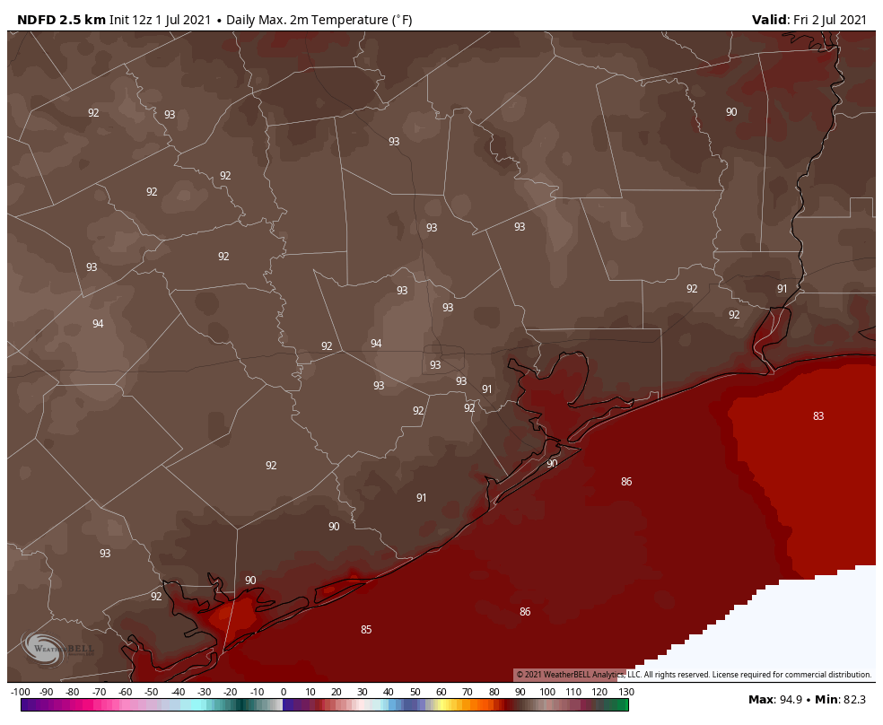
Thursday morning track forecast for Elsa. (National Hurricane Center)
As for where Elsa ends up, anywhere from the eastern Gulf of Mexico, to Florida, to east of the Florida peninsula is possible next week. Texas is unlikely to see any winds from Elsa, but the overall setup may generate additional moisture later next week. We’ll just have to wait and see.