Good Sunday morning to you. As promised, we are here with an update on the tropics, as we watch the potential for development in the Gulf this week.
Quick Houston weather update
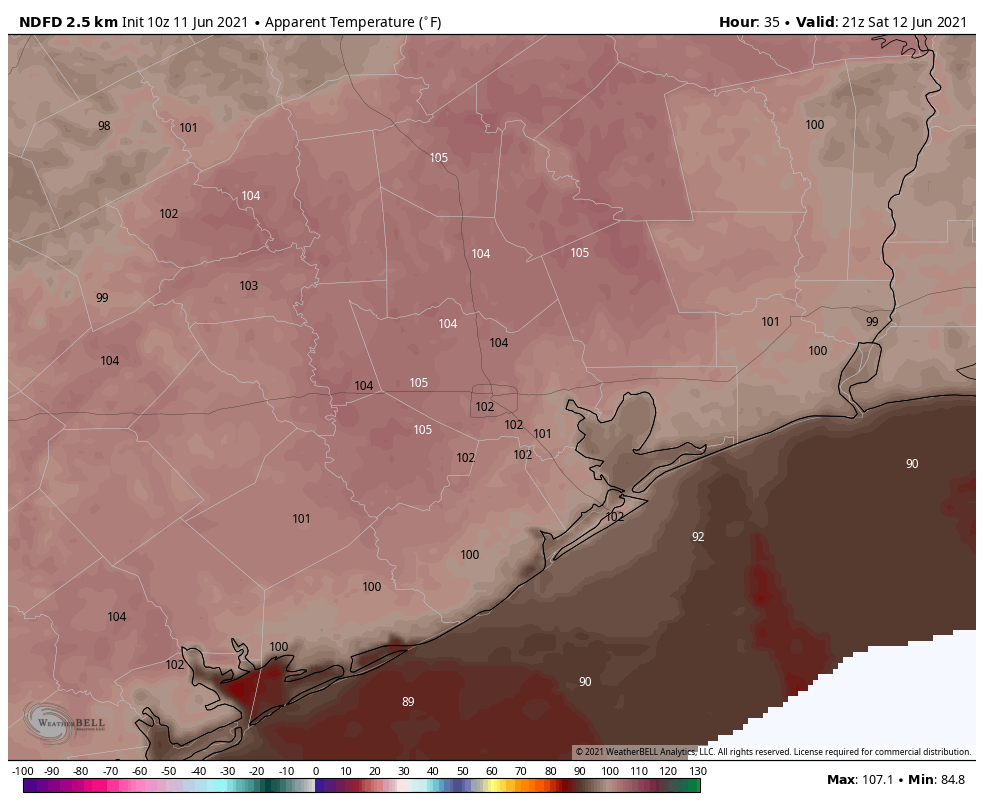
I just want to lead with a quick update on our near-term weather here in Houston. It hit 98° yesterday officially, and we’re running slightly hotter already today. We typically don’t see our first 98° day until July 9th, so we’re running close to a month ahead of schedule there. That doesn’t mean we’re necessarily headed for 100° this afternoon, but it’s going to be another scorcher. Please take it easy outdoors. In addition, it’s an ozone action day, so anyone with respiratory sensitivity will want to limit outdoor activity.
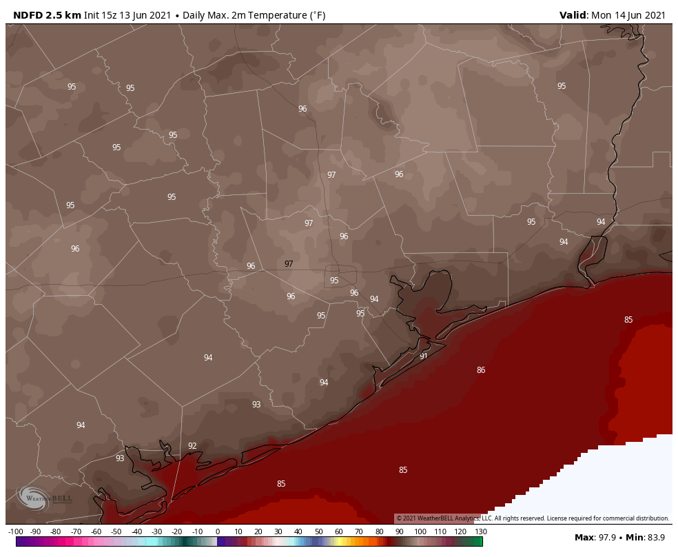
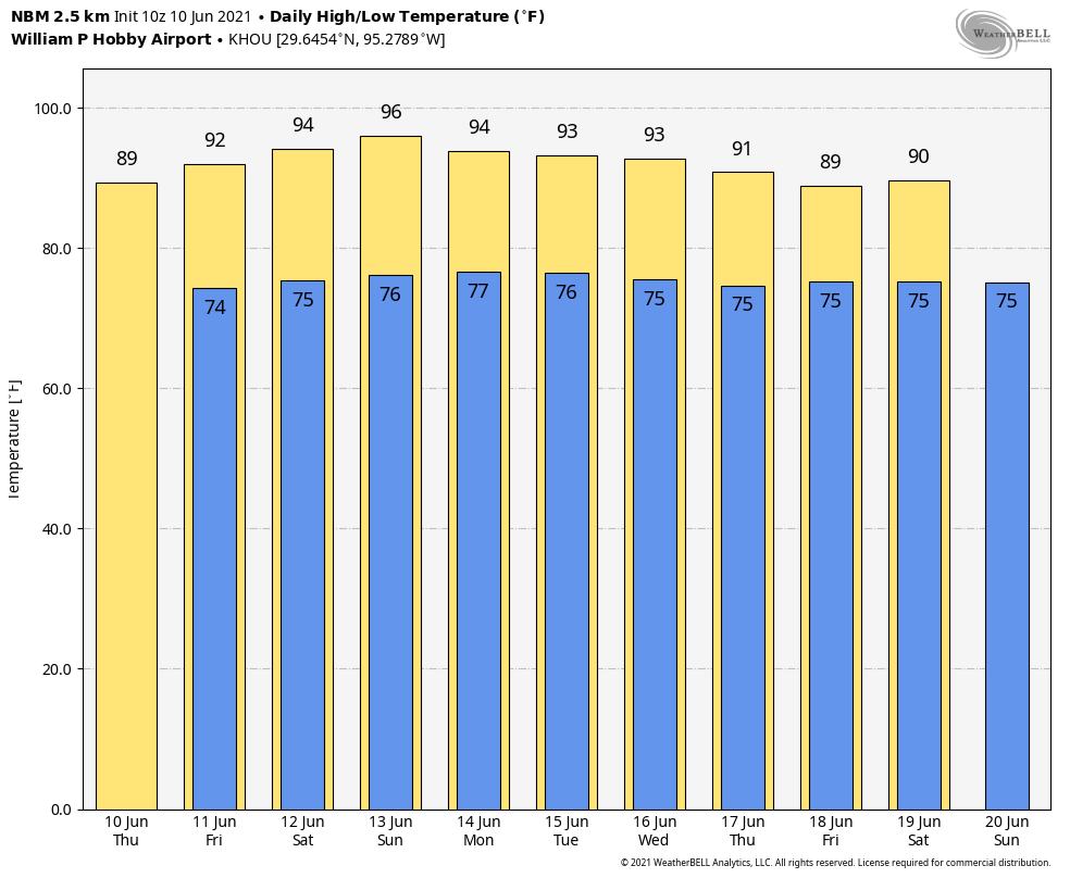
The big difference between today and prior days is with rain chances. Yesterday was close to zero. Today will be slightly above zero. So we feel at least a few locations, possibly parts of the city, will see a cooling downpour this afternoon. Outside of that, it’s just going to be red hot. Tomorrow and Tuesday will likely see a few more scattered showers and storms in the afternoon. Prior to those developing, look for sun, clouds, and temperatures into at least the mid-90s, with morning lows in the 70s to near 80° in spots.
Tropical update
Alright, the main point of today’s post is to discuss the tropics.
One sentence summary: A tropical system seems likely to form in the Bay of Campeche over the next 5 days, and while we will watch it closely, we are currently expecting a fairly disorganized system with a decent chance that the majority of impacts remain shunted off to our east.
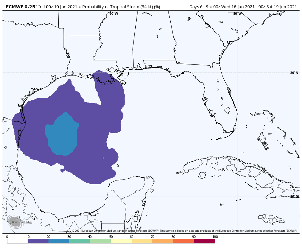
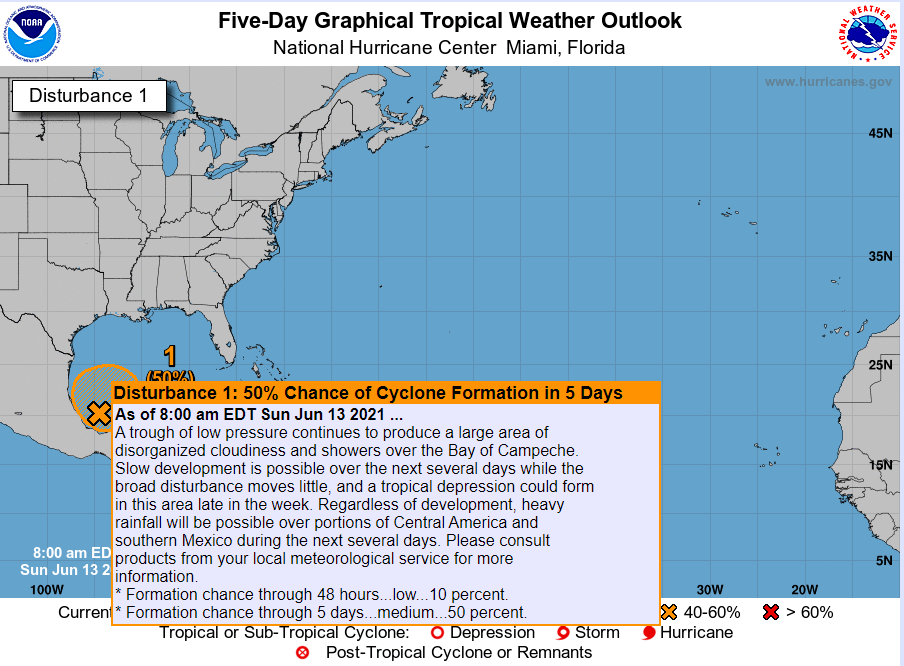
In meteorological speak, when we have a specific disturbance we want to get more information on before it gets close to becoming a tropical depression, it is labeled an “Invest,” or area to investigate. In the Atlantic basin, invests are labeled 90L to 99L, and then the list recycles. In the southern Gulf, we now have Invest 92L.
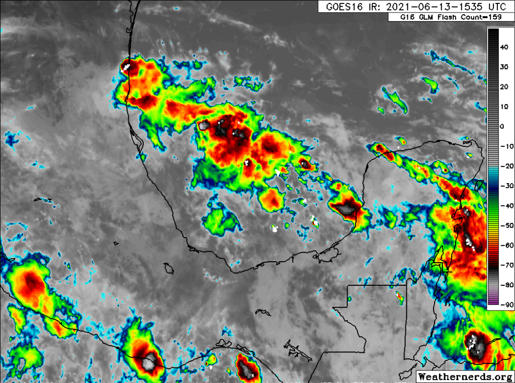
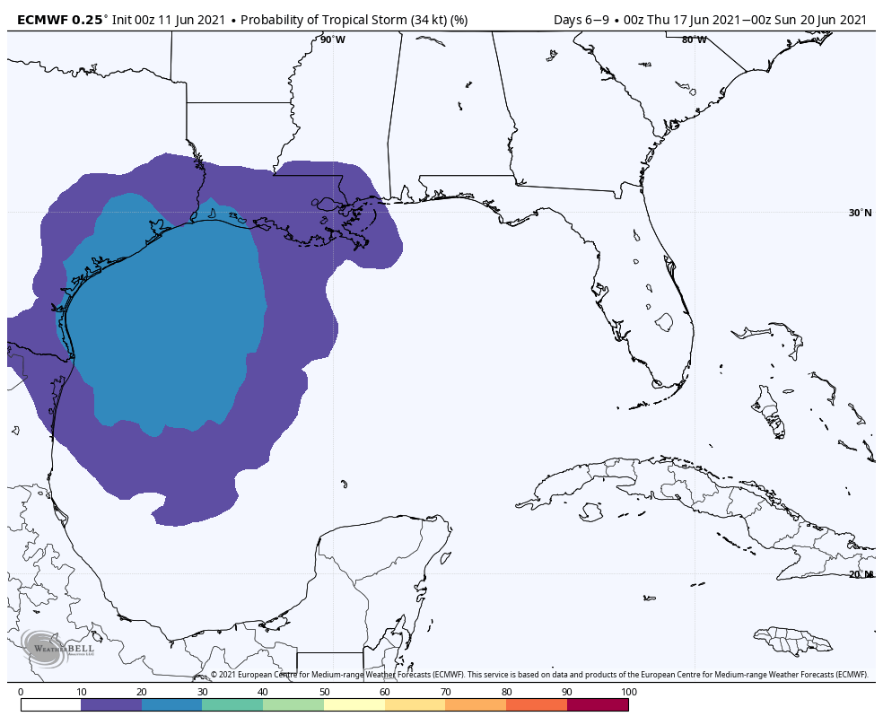
From the satellite image above, you can see a blotchy area of thunderstorms and little organization. This is mostly what we expected to see this weekend. Development from 92L is probably going to be slow. In fact, the National Hurricane Center says the chances of a depression forming seem to be most likely later this week, so we’ve got some time to watch. As of now, they are assigning 50 percent odds of development over the next 5 days.
In addition, this system is likely to fester and sit over the southern Gulf the next few days without moving much. So that means any impacts here in Texas from 92L likely would not occur until very late this week or next weekend. You might ask why it’s going to struggle to develop if it’s sitting over the southern Gulf, which is about 2 to 3 degrees warmer than normal. Well, for one, it’s sitting over 25 kts. of wind shear, with an area of 40 kts. of wind shear to the north. That’s prohibitive to development.
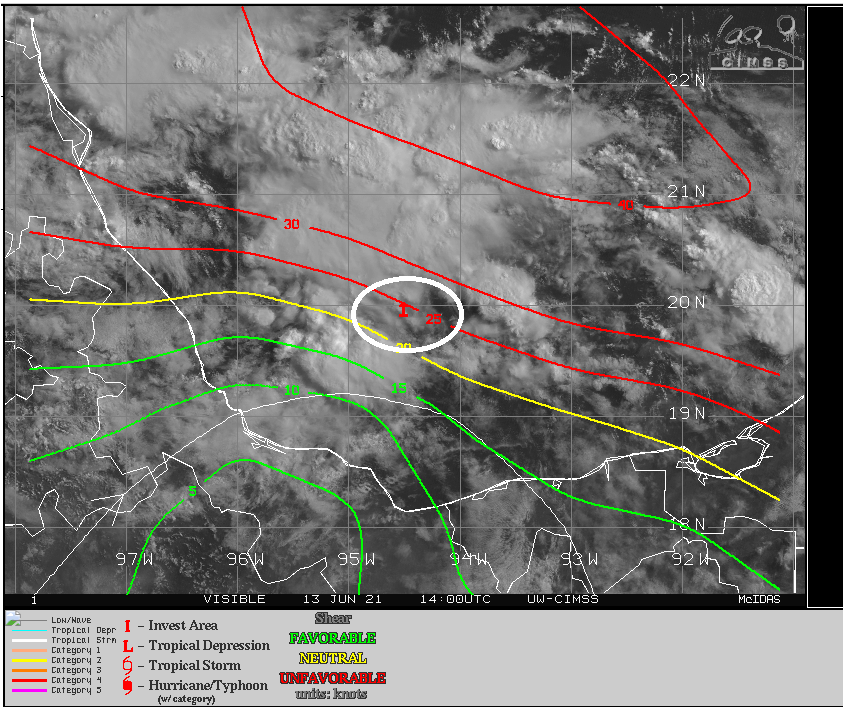
This shear is not expected to relax much over the next few days. In fact, this wind shear may linger in place through Wednesday or Thursday or beyond.
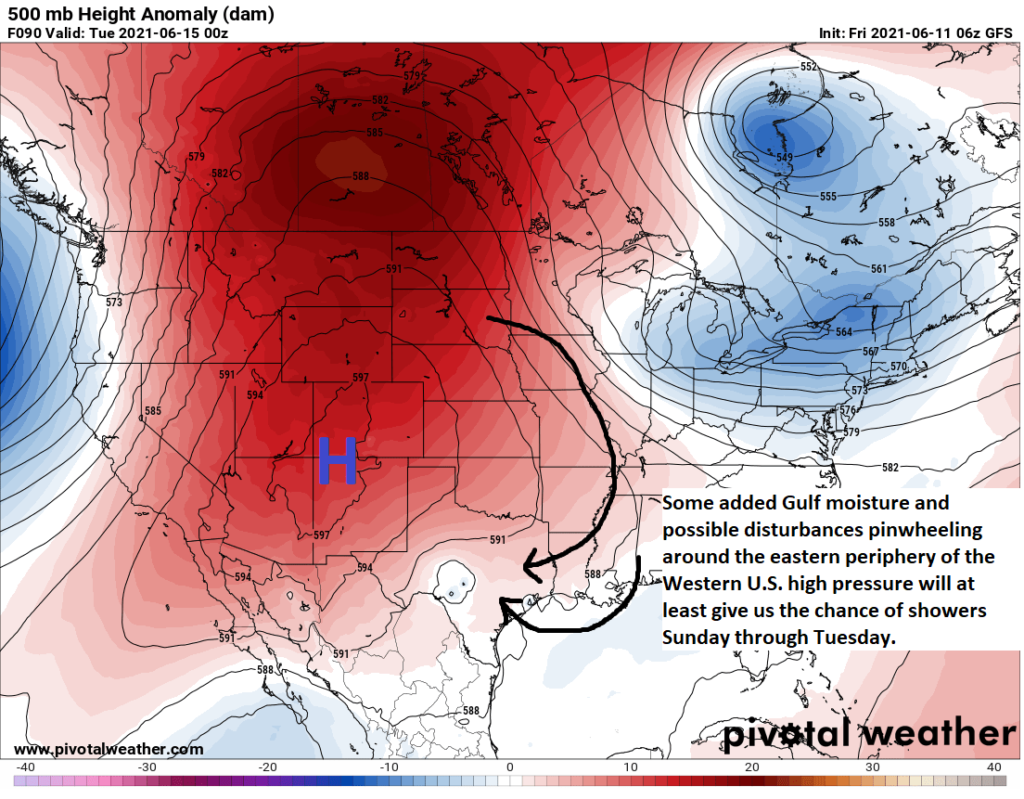
Given a lack of serious steering currents right now, the system is expected to stay in place over the Bay of Campeche. But, as the week progresses, a strengthening ridge in the Western US, a strengthening trough along the East Coast of the U.S., and a building ridge in the western Caribbean will act to gradually invite 92L to drift northward. The exact track of this system will depend on the actual strength of these features and exactly where the center of Invest 92L forms. In general, modeling is telling us to probably expect a northward drift later this week, with some acceleration to the Gulf Coast on Friday or Saturday. From there, it seems possible that the forward speed may slow. But details on that aspect of things are difficult to really pin down right now. Models seem to favor a track of the center toward areas just east of Houston, keeping most of the Houston area on the less impactful side of the system, but again, it’s too early to be too confident in any track specifics.
In terms of intensity, I think two things are going to seriously inhibit how strong Invest 92L can ultimately get. The first is shear, as noted above. I don’t see any evidence on models that this is going to relax much. That’s the first hurdle this system will have to overcome. It may also further help us in that wind shear could allow for much of the more significant system impacts from rainfall to pushed even farther to our east. For those of you reading us from places other than Houston, it’s important to realize that these early season systems are rarely ever symmetrically put together and impacts from heavy rain in particular can extend hundreds of miles to the east of the center.
The other thing that might lower 92L’s ceiling for intensity would be dry air coming off Texas.
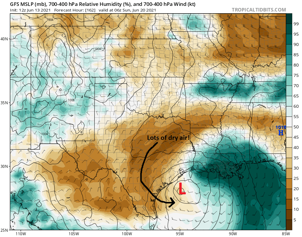
If you look above, you are seeing the GFS forecast of atmospheric relative humidity several thousand feet above us for next weekend. The brown over Texas indicates dry air. The red “L” is the approximate center of 92L as forecast by the GFS on Sunday morning. Don’t focus too closely on that. The green color indicates more ample atmospheric moisture. What is this telling us? Even if the track of 92L shifts 150 miles in either direction, it’s still going to be dealing with dry air possibly getting wrapped in from Texas. That should limit the ceiling of intensity as the storm comes north. Moisture from the storm may be displaced a good bit east of the center as well.
The bottom line, as is often the case with these early season storms: While we will continue to watch closely, at this point we don’t see this as a serious wind-making risk for the area. We are viewing this as a rainfall risk, as well as for some coastal impacts (minor to moderate tidal flooding, overwash, rough seas, etc.). Sitting here on Sunday, I don’t think we need to be especially worried about this either way, but I do feel we should watch things closely this week, just in case anything changes, particularly with respect to rainfall. It’s probably not a bad idea to check in on the forecast once per day and make sure we’re still status quo on things. But truthfully, I feel mostly at ease with where things stand today. Sure, that could change, but for now, we’ll take it!
Look for the latest in our usual Monday morning update tomorrow. Meanwhile, stay cool!