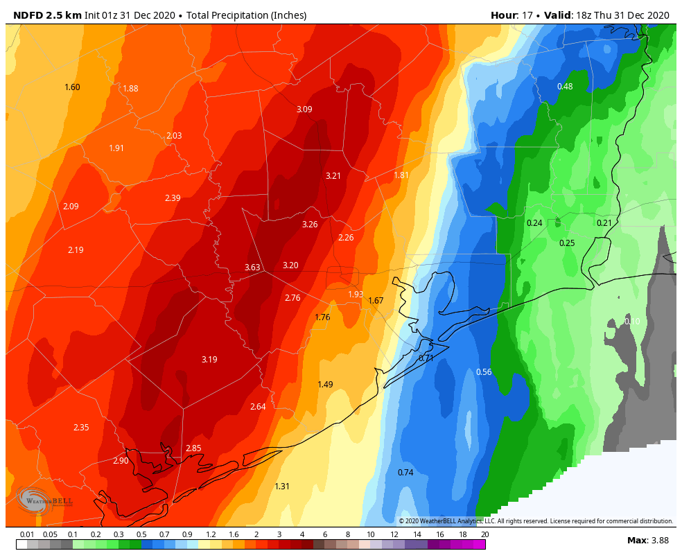
So far the forecast for Houston remains on track. Nearly all of the heavy rainfall has remained west of Interstate 45, with generally 1 to 4 inches falling between Wednesday afternoon and Thursday morning. A few areas, such as western Montgomery County, saw as much as 5 inches. Now, we’ve got to get through one more day before skies clear this evening and the new year dawns brighter.
Thursday daytime
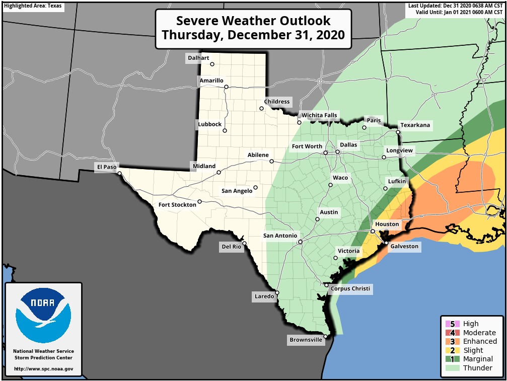
After storms waned during the wee hours of Thursday, we’re starting to see activity fire back up west of Houston around sunrise. This mass of storms should generally move from west to east during the daylight hours, bringing an additional 1 to 3 inches across much of the Houston area. However, the forecast will be complicated by the front’s interaction with a low-pressure system presently along the Texas coast, near Corpus Christi. As this low moves north today, it could induce some severe weather to the south and east of Houston—especially the closer one gets to Beaumont and Port Arthur. The threat will be strong winds amidst severe thunderstorms, and possibly a few tornadoes. The area of greatest threat is shown below.
Severe weather outlook for New Year’s Eve. (NOAA)
New Year’s Eve evening
The cold front presently draped across the Houston region will finally lift to the northeast this afternoon and evening. I think rains should be gone from the central Houston area by around 4 to 6pm CT today, and rapidly pull away to the east after that time. Temperatures after sunset will quickly drop into the 40s, with brisk westerly winds blowing at 15 to 20 mph, and higher gusts. Bottom line: If you’re outside when the clock strikes midnight, it will “feel” like it is in the 30s.
New Year’s Day
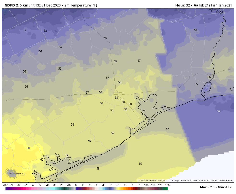
Lows will drop to around 40 degrees before rebounding into the upper 50s on New Year’s Day. After some morning clouds, skies should be mostly sunny.
Forecast high temperatures for New Year’s Day. (Weather Bell)
Saturday and Sunday
Expect more sunshine throughout the weekend, with highs in the mid-50s on Saturday, and low 60s on Sunday.
Next week
Houston will likely see a slow warming trend next week before another front arrives on Wednesday or Thursday to keep our weather reasonably cool. This one may bring some additional rain, but nothing like we’ve been experiencing with the current front.
2020 Hurricane Season
If you missed it, we published Part I of our hurricane season wrap-up on Wednesday, and will publish Part II later today.
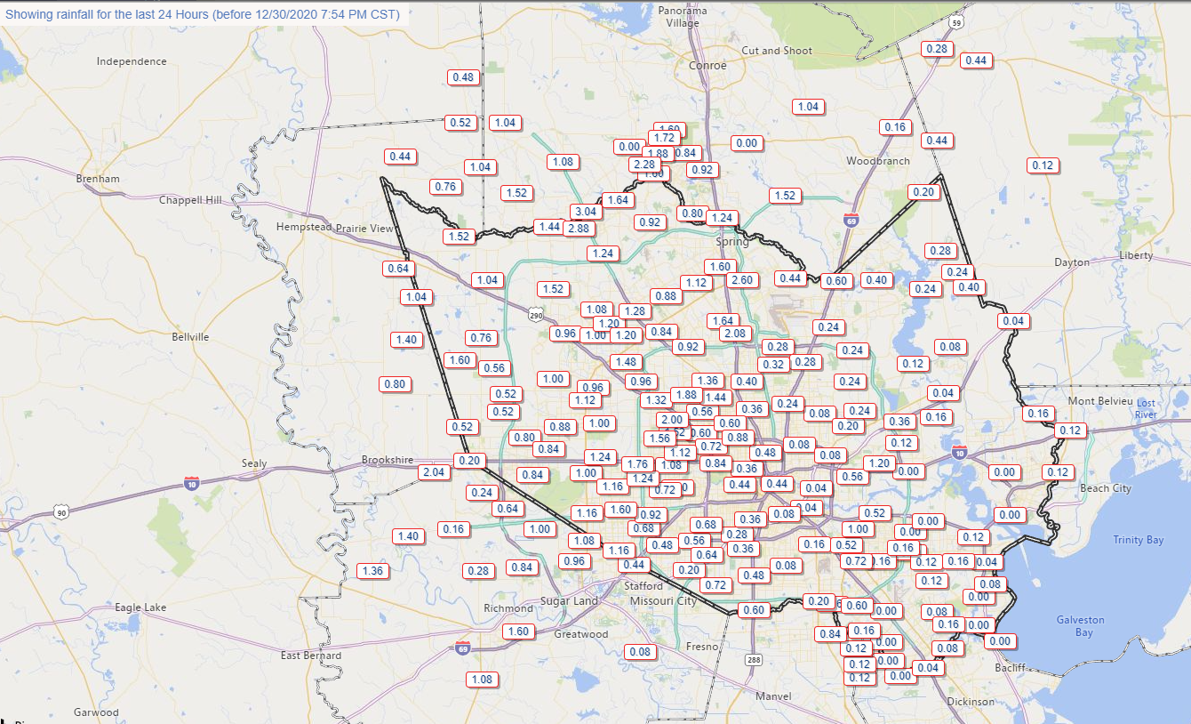
Rainfall this afternoon was quite vigorous across the Houston area, with a few places seeing as much as an inch of rain in about 15 minutes’ time.
Rainfall has been mixed across the area, but some places in western Harris County have seen 3 inches of rain or more so far. (Harris County Flood Control)
This has added up with the gauge at Spring Creek and SH 249 for instance already over 3 inches of rain today. For most areas, this has been manageable with just some minor street flooding.
The trouble tonight is that the front is going to approach and stall west of I-45 for a time. You can see this well on the HRRR model for example, which is showing the front (roughly the boundary between warmer and cooler colors here) stalled out over Harris County tonight and into tomorrow morning. This animation runs from 7 PM Wednesday to Noon Thursday.
HRRR model shows the cold front basically stalled out over western Harris County most of tonight and early Thursday, leading to repeating rounds of rainfall, some heavy. (Weather Bell)
In this time, repeated rounds of rainfall, some heavy, will impact areas primarily west of I-45 (until you get north of Conroe). Additional rainfall during this time on top of what has already fallen, will average about an inch or so east of Houston and 1 to 4 inches west of the city (presume about 1 to 3 inches in the city itself). There will likely be some pockets of higher amounts up to 5 or 6 inches or so west of Houston. Those higher amounts would be most likely in western Harris, western Montgomery, Grimes, Fort Bend, Wharton, or Waller Counties.
Forecast rainfall on top of what has fallen through 7 PM Wednesday will be 1 to 3 inches on average with higher amounts possible west of Houston. (Weather Bell)
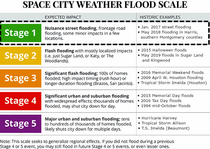
This could lead to some localized flooding, and for that reason, we are going to implement the Space City Weather Flood Scale at Stage 1 for tonight and Thursday.
(Space City Weather)
We will go with a Stage 1 event for the western half of the area, which generally means mostly nuisance street flooding. But there will likely be rises on area creeks as well, particularly Willow Creek, upper Spring Creek, and upper Little Cypress Creek. So we will watch and escalate if necessary, but we think this will behave for the most part in our area. Still, please exercise caution, especially if you have to be out for whatever reason tonight and tomorrow morning. A Flash Flood Watch is posted for Houston and points west through tomorrow afternoon.
Rain should rapidly end from southwest to northeast across the region tomorrow afternoon and evening.
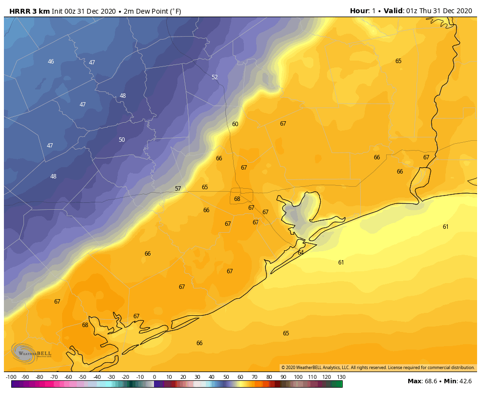
In addition to the rainfall, we did see a tornado warning at one point for Harris and Fort Bend Counties this afternoon. We think the severe threat will be fairly minor tonight, but we can’t entirely rule out a storm or two trying to get a little excitable, particularly if it can develop east of the front. For folks in Galveston, Chambers, and Liberty Counties, this would be the primary way you would see rain tonight, from a rogue storm or shower ahead of the main action to the west. Not too serious a concern right now, but something we’ll keep tabs on.
Today and tomorrow, Matt and I will be publishing two posts to summarize the 2020 Atlantic hurricane season, its effects on Houston, and implications for the future. In Part I, today, I will discuss the overall activity this season, and share some thoughts about Hurricane Laura. Part II, tomorrow, will focus on Tropical Storm Beta and what we can learn from this season about future hurricane activity.
2020 season
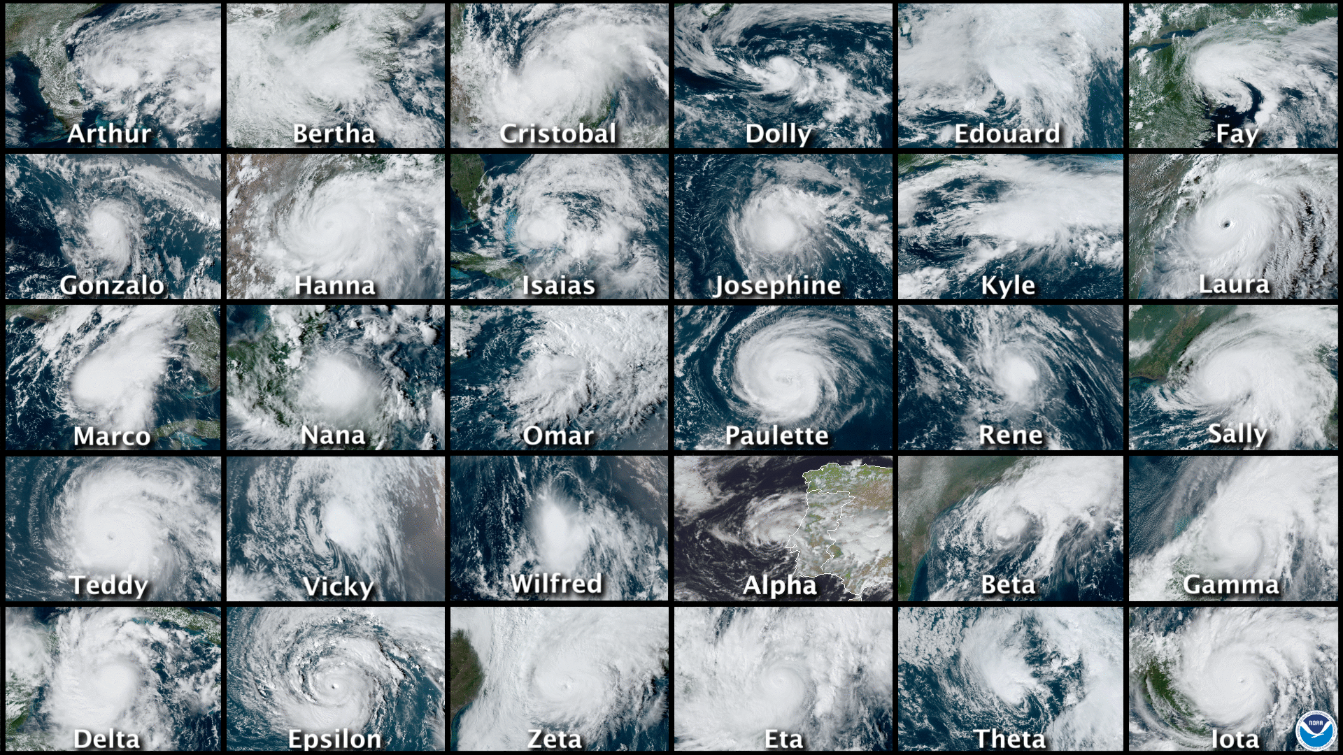
The numbers for the 2020 season are sobering. Across the Atlantic basin—which includes the Atlantic Ocean, Caribbean Sea, and Gulf of Mexico—there were a total of 30 tropical storms and hurricanes. This surpassed the previous record of 28 set in the year 2005, the historic year of Katrina, Rita, and Wilma. For only the second time, this year, forecasters at the National Hurricane Center in Miami ran out of names and had to resort to using the Greek alphabet.
From Arthur to Iota, what a year it was. (NOAA)
Notably, a dozen of these tropical storms and hurricanes made landfall in the United States, crushing the previous record of nine landfalling tropical storms or hurricanes set in 1916. The state of Louisiana alone experienced five landfalls. (Thanks to the tremendous results of our 2020 fundraiser, Space City Weather will donate $5,000 to SBP, to assist with that state’s recovery efforts). At least one part of Louisiana fell under coastal watches or warnings for tropical activity for a total of 474 hours this summer and fall. And Hurricane Laura, discussed below, became the strongest hurricane to make landfall in Louisiana since 1856.
Harris County’s Jeff Lindner has catalogued some of this year’s other superlatives:
On September 14, five tropical cyclones were ongoing at the same time in the Atlantic basin (Sally, Paulette, Rene, Teddy, and Vicky). This ties September 1971 for the most number of tropical cyclones at the same time in the basin.
On September 18, three tropical cyclones formed within in six-hour window (Wilfred, Alpha, and Beta). This is only the second time in recorded history that three tropical cyclones have formed in such a short time period (1893).
Ten tropical storms formed in the month of September, the most for any month on record
A total of 10 systems experienced rapid intensification (35 mph increase in wind speed in 24 hours), Hanna, Laura, Sally, Teddy, Gamma, Delta, Epsilon, Zeta, Eta, and Iot).
Hurricanes Delta, Iota, and Eta experienced winds speed increases over 100 mph in 36 hours or less.
Of the 6 major hurricanes in 2020, four were in October and November, and bore Greek alphabet names (Delta, Epsilon, Eta, and Iota).
Hurricanes Eta and Iota both made landfall only 15 miles apart along the Nicaragua coast both as category 4 hurricanes.
Hurricane Iota (160 mph) became the latest category 5 hurricane on record in the Atlantic basin, and the second strongest November hurricane on record only behind the 1932 Cuba hurricane (175mph)
NOAA hurricane hunters flew a total of 86 missions for 678 flight hours and 102 eyewall passages. A total of 1,772 dropsondes were deployed.
Despite all of this, however, the 2020 Atlantic season was not all that extraordinary by some important measurements. Perhaps our best tool for determining a season’s overall activity is “accumulated cyclone energy,” or ACE, which sums up the intensity and duration of storms. For example, a weak, short-lived tropical storm counts for almost nothing, whereas a major, long-lived hurricane will quickly rack up dozens of points. The ACE value for the 2020 Atlantic season was 179.8. This significantly higher than the climatological norm for ACE values (about 104), but does not quite make the top 10 busiest Atlantic seasons on record, which is paced by the 1933 and 2005 seasons.
The bottom line is that the 2020 hurricane season was in line with our expectations for 2020 to produce a total cluster of a year. Fortunately, we survived. In Matt’s post on Thursday, he’ll discuss what this may mean for the 2021 season.
Hurricane Laura
It’s also worth reflecting for a moment on what I consider to be the most threatening storm of the year for Houston. There was a time in late August when it appeared that Hurricane Laura might strike Houston as a major hurricane. Personally, it was rather unsettling.
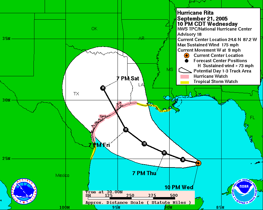
I first began writing extensively about hurricanes back in 2005. This was before I had become a meteorologist, and just after I started a blog for the Houston Chronicle. First, I tracked Hurricane Katrina and then, much closer to home, there was Rita. You may not remember the storm, or it may not have formed much of an impression on you. But it certainly did on me. I distinctly recall the evening of September 21, 2005—a Wednesday. Rita had intensified to 175 mph over the central Gulf of Mexico, and it was forecast to make landfall a little more than two days later just below Houston on the Texas coast. This was the worst-case scenario for our region. I’d bought a home in the Clear Lake area a couple of years earlier. Not going to lie, this one scared me. Eventually, Rita weakened some, and turned, making landfall near the Texas-Louisiana border.
Hurricane Rita forecast for Sept 21, 2005, about 30 hours before landfall. (National Hurricane Center)
Since then, Rita has been the measuring stick for me in terms of dreading a hurricane landfall. And in those 15 years, no storm has ranked so highly as Laura did in late August. Why? Because although Houston has been battered by a strong storm surge (Hurricane Ike) and massive floodstorm (Harvey) in the last dozen years, it has not seen a major wind storm in nearly six decades. That was the potential Laura had with a track that could have come to Texas, across a very warm Gulf of Mexico. Ultimately, that didn’t happen, Laura turned away from Houston and made a devastating landfall in Louisiana.
Thanks to fine forecasting and smart calls by local officials, the greater Houston area was spared a major evacuation. But Laura was a close call in many ways for the nation’s fourth largest city. And I won’t soon forget it.
Sponsor Note from Reliant
A big thank you goes to the Space City Weather team for keeping Houstonians informed during the 2020 hurricane season. Just as Eric and Matt provide hype-free forecasts to ensure readers are prepared for a storm, Reliant keeps Houston powered with personalized electricity plans and back-up power solutions. Reliant is also here to help before, during and after the storm with helpful guides, tips and information on reliantstormcenter.com. We all hope for a quiet hurricane season in 2021, but know we’ll be informed and in good hands with Eric and Matt should any storms develop. Thanks for all you do, SCW!
The big picture for our weather during the last two days of 2020 remains the same: A slow-moving front will approach Houston, but likely stall west of the metro area. This will make for a stormy period from Wednesday afternoon into Thursday afternoon before conditions clear up heading into the new year. The first few days of 2021 should be clear and cool for the Houston area.
Wednesday
It’s mostly cloudy and humid this morning, with temperatures only falling into the low- to mid-60s for much of the region. For today, southerly winds will be gusty, perhaps as high as 20 mph. High temperatures later today will climb into the mid-70s, and we’ll start to see some scattered showers later this morning. The approaching front will be a larger driver of storms, and where it stalls will determine which areas see the heaviest rainfall during the overnight hours. For now, it seems the front will stall just west of Harris and Montgomery counties. Rain chances will increase during the afternoon and especially overnight hours.
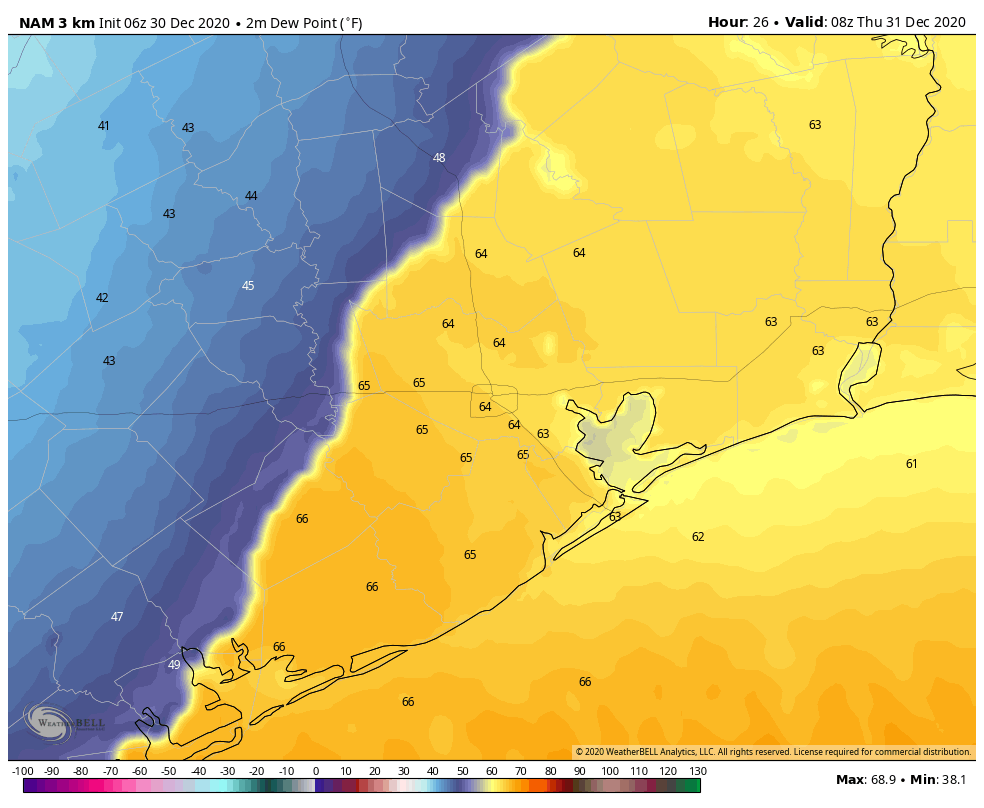
NAM model forecast for location of stalled front in the wee hours of Thursday. (Weather Bell)
Thursday
With the front stalling just west of Houston, our region is likely looking at another warm night, in the 60s, and a humid day. With the perturbed and moist atmosphere, rain chances will persist through much of Thursday afternoon, with widespread totals of 2-3 inches west of Interstate 45, and 1-2 inches for areas east of Interstate 45 between now and then. Finally, the front will shove through the area on Thursday afternoon, and this should bring an end to precipitation by sunset, or shortly before. Dry, westerly winds will follow the front’s passage, with temperatures dropping into the 40s as midnight approaches.
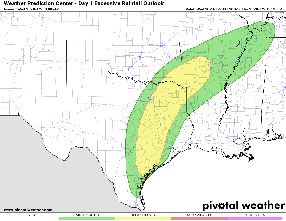
Areas in yellow have a “slight” chance of seeing excessive rainfall. (Pivotal Weather)
New Year’s Day
We’re expecting a cool and clear day, with highs in the upper 50s, and westerly winds at 5 to 10 mph. Lows will drop to around 40 degrees on Friday night.
Saturday and Sunday
The weekend looks sunny and fine, with highs in the upper 50s on Saturday, and lower 60s on Sunday.
Next week
We should see a warming trend next week, with highs perhaps reaching the 70s by Tuesday or so. Another front may be in the cards by around next Thursday, although overall confidence in the models is low. Regardless, rain chances after New Years’ Eve will remain low until that time.