Houston warms somewhat, but dangerous ice storm looms overnight

Much of the Houston area has warmed to at or above-freezing levels today, but just as the region can start to take a breath, Mother Nature is readying a second punch. It will come tonight in the form of another round of precipitation, which will fall as freezing rain for inland areas.

Tuesday night

Road conditions have been improving today, and should remain so until later evening, or possibly even midnight. After this point precipitation from a coastal low pressure system will begin overspreading the area. The key question is where the freezing line falls, north of which will produce freezing rainfall. Initially, this line will likely fall roughly along Interstate 10, and then may migrate northward as temperatures warm Wednesday morning. The big concern this presents is accumulating freezing rain on roads and power lines, especially north of Highway 105.

The freezing line will set up near Interstate 10 tonight. (Weather Bell)

The bottom line: Travel in the northern half of Harris County, and points north, could become problematic to rather dangerous late this evening, and should be avoided after about 10pm.

Wednesday

The precipitation will come to an end by around noon on Wednesday, and then it becomes a game of when air temperatures will warm enough to melt off any ice on roadways. For now I think that will occur before noon in Harris County, and probably after noon in Montgomery County. There likely will be some point around Highway 105, or north, where it does not get warm enough to burn through the ice. Where that will be? Can’t say for sure right now.

In Houston itself, expect highs to reach the upper 30s, with lows dropping just below freezing Wednesday night. Some additional light precipitation is possible Wednesday night, but at this point is not expected to cause major additional problems.

Thursday and beyond

Thursday looks cloudy and cool, with highs in the upper 30s to 40 degrees. But the rain will be over. Thursday night will provide one more sting, with lows dropping into the 20s. After this we’ll be off to the races in terms of sunshine and warming. We should see mostly sunny skies into early next week.

We’ll have a comprehensive update for you in the morning. Please stay safe, and as warm as these trying conditions permit.

After this morning’s extreme cold, freezing rain returns tonight

Good morning. Temperatures are bottoming out at 10 to 15 degrees across much of the metro area in what will be the region’s coldest night in more than three decades. The city’s official low temperature, measured at Bush Intercontinental Airport, looks to be 12 degrees.

Making matters worse today, power outages persist across the state, with more than 4.1 million customers without power. Many of these power outages are concentrated in and around the Houston area. Weather conditions will begin to slowly improve today, but there are no reliable estimates for when widespread power will be restored. We discussed why in a post on Monday.

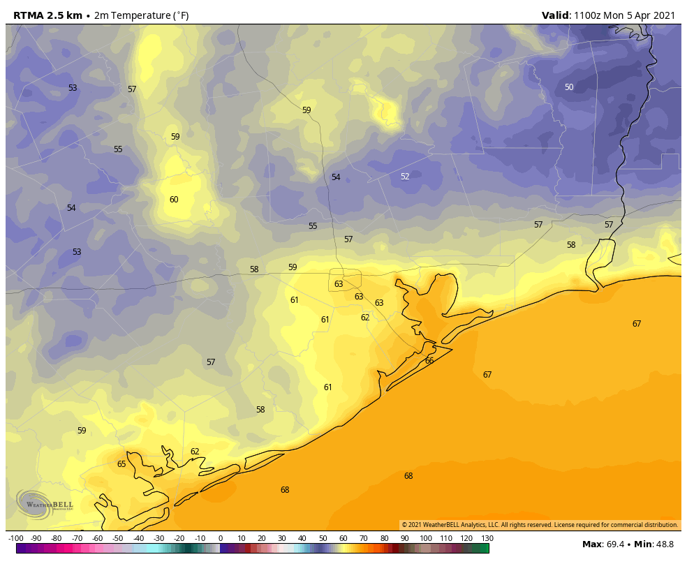
Your 7 am CT temperatures across Texas on Tuesday morning. (Weather Bell)

Tuesday

Clearing skies and winds shifting to come from the east later today will help warm temperatures somewhat. Most areas south of Interstate 10 should reach above freezing later today, but road conditions are iffy this morning. Some streets dried out with Monday’s sunshine, but roads and bridges that remained wet iced over again on Monday night. Sunshine later this morning should help with most roadways later today.

However, precipitation will return this evening and overnight as moisture moves in from the Gulf of Mexico. Most likely the precipitation will begin around midnight, but we can’t rule out it starting earlier. For Houston, it should begin as rain, but could transition to freezing rain over night. North of a line from Matagorda to Houston to Winnie, we can probably expect temperatures to freeze tonight. Galveston and Brazoria counties, for the most part, are unlikely to rain transition to freezing rain as they will remain above 32 degrees.

Bottom line: Travel Tuesday evening and overnight in Houston and could be very problematic due to icy roads. For Montgomery County and points north accumulating freezing could be exceedingly dangerous, and pose problems for power lines.

The coastal tier of counties will likely escape a freeze on Tuesday night. (Weather Bell)

Wednesday

By mid-morning Wednesday, or shortly thereafter, temperatures should rise above freezing across nearly all of the metro area, and this should melt ice. Highs in Houston will reach about 40 degrees, if not a touch warmer. Some additional sleet or light snow is possible Wednesday night, but this seems unlikely to be too problematic. Areas south of Interstate 10 are unlikely to freeze.

Thursday

The precipitation should end by late Wednesday night, setting the stage for a dry and cold Thursday, with highs near 40 degrees. Expect one more very cold night on Thursday night, with lows in the 20s. Fortunately, it will be dry,

Friday, Saturday, and Sunday

As high pressure comes to dominate our weather, expect sunny skies on Friday, with highs in the 40s, with temperatures reaching the 60s by the weekend. At last, our winter blast will be at an end. Not soon enough.

Tracking how cold it will get tonight in Houston

We again want to express our best wishes and thoughts for so many of our readers, Houstonians, and Texans who are outright suffering tonight because of the combination of a true “tail event” and who knows what else happened with the power grid (which I sincerely hope is transparently communicated to Texans in the days and weeks ahead). Please, if you’re one of the fortunate ones tonight, check on anyone you know that may not be so fortunate.

That said, we are a weather blog first and foremost and we want to let you know about a couple things: How tonight’s forecast is tracking and an update on Wednesday’s storm.

How cold tonight?

We’ve been asking this question for days when it was apparent that tonight would be the main event for cold. So, we have a lot of models and data and whatnot, but let’s actually compare to data from the most recent comparable event: December 1989. On December 23 and December 24, 1989, Houston (Bush Airport) hit 7° and 11° respectively, close analogs to what we believe tonight’s low temperature will be. One way to check on how things are going is to track the temperature at Bush Airport hour by hour and compare to the hourly observations in those events, as well as the NWS point forecast from just before 8 PM this evening.

Hourly Temperatures at IAH Airport December 1989 vs. February 2021

12/23/1989 12/24/1989 2/15/2021 NWS Point Forecast
6:00 PM 19 24 21 21
7:00 PM 18 19 20 20
8:00 PM 16 16 19 17
9:00 PM 16 15 18 15
10:00 PM 15 14 14
11:00 PM 14 14 13
12:00 AM 13 12 12
1:00 AM 12 11 11
2:00 AM 11 12 11
3:00 AM 10 11 10
4:00 AM 10 11 9
5:00 AM 9 11 8
6:00 AM 7 11 8
7:00 AM 7 12 9
8:00 AM 8 15 12
9:00 AM 10 22 15
10:00 AM 14 27 18

Through 9 PM at least, we are coming up short of both nights from 1989 as well as the current forecast. All that said, it’s very early still, relatively speaking, and temperatures on nights like this can easily drop like a rock under the right conditions. So don’t read too much into what you see here just yet, but I felt this would be an interesting way of looking at things.

If you are unable to sleep or have too much time on your hands tonight (like me, probably) and you want to track our progress through the night, you can check out real-time IAH observations at this link.

(Editor’s note: Replace “IAH” in that link’s URL with whatever airport code you desire, if you’d like to track conditions at that location. Some local ideas? GLS for Galveston, HOU for Hobby, EFD for Ellington Field, LVJ for Pearland, SGR for Sugar Land, TME for the west side of Katy, DWH for Tomball, and CXO for Conroe. You must keep the “K” before those three letters though!)

Wednesday’s Storm

The National Weather Service has issued a Winter Storm Warning for Wednesday’s storm now.

A Winter Storm Warning has been posted for Wednesday’s storm for the counties shaded in pink, essentially from the City of Houston north and west. (NOAA)

Here’s what I can tell you confidently tonight:

  • The precipitation will fall as either plain rain or freezing rain. Sleet or snow are unlikely in our area.
  • Precipitation should break out around Midnight, give or take a few hours Tuesday night/Wednesday morning.

Exactly who sees freezing rain vs. plain rain? That’s the forecast challenge right now, as shallow, dense cold air is not always easy to dislodge. If we look at the HRRR model forecast for tomorrow evening at midnight, you can see roughly where it predicts the freezing line to be located.

The HRRR model suggests that temperatures across most of the northern half of the Houston area will be below freezing when rain begins tomorrow night. (Weather Bell)

This is essentially just north of US-59 to Houston and east along or just south of I-10 to Port Arthur. The European model and NAM model are slightly warmer than this, and the GFS model is very similar to the HRRR. All models show temperatures getting above freezing by mid-morning or so Wednesday across the entire region. Expect at least a few hours of freezing rain in Houston, with a longer duration as you go north. Total icing may be as much as a glaze to a tenth of an inch across Harris County, with higher amounts possible as you go north into northern Liberty and Montgomery Counties and even more from Walker County northward. For most of us this shouldn’t be a “power outage” issue, but rather a travel one. Expect travel to become difficult to impossible north of I-10 or US-59 after midnight Tuesday night, but we will likely see improvement from south to north after sunrise.

Things could change, but that’s what it looks like right now. We want you to be aware and be smart about this next storm, so that’s why we have this here. Eric will have more for you in the morning. But right now, just focus on getting through tonight. Our thoughts are with you. Please stay safe.

The power situation is disastrous, and it likely won’t be fixed tonight

Millions of customers in the greater Houston region continue to experience some of our coldest weather in decades without the benefit of electricity to heat their homes. (Full disclosure, I am one of them, and have been since 2 am CT. I am typing this from my office, wearing a winter jacket).

To understand what is going on, and when the power might return, I spoke this afternoon with Kenny Mercado, CenterPoint Energy’s Executive Vice President for Electric Utility.

First, it is important to understand how power generation works in Texas. Power plants across the state generate electricity from natural gas, coal, wind, solar, and other sources. This is all put onto the grid, which is managed by the Electric Reliability Council of Texas. Then it is up to companies like CenterPoint to deliver electricity to your home through its network of lines and poles. (Reliant, the sponsor of Space City Weather, markets and sells electricity to the customer. They are not directly responsible for generation or delivery).

What happened

As of 2 pm on Monday, about 1.1 million of CenterPoint’s 2.6 million customers are without power in the greater Houston area. Mercado said customers without power are unlikely to get electricity back today, and quite possibly not tonight—when temperatures are forecast to reach near all-time record lows.

Two things happened last night to contribute to these outages. First, demand was extraordinarily high across the state, Mercado said. And then, beginning at about 1 am, generating units started to shut down. This is almost certainly due to extremely cold conditions. Eventually about one-third of the anticipated capacity went offline. This included a handful of freezing wind turbines, but the majority of the volume losses were due to coal and natural gas plants going offline.

CenterPoint had been planning to manage increased demand overnight and today through rolling outages, which would last about 30 to 45 minutes. However, when power plants began going offline, CenterPoint had to prioritize circuits that fed power to emergency units, such as hospitals and police stations. After this, there just was not enough capacity to implement rolling outages so if your power went out, it mostly stayed out. (Note: If you have power, do your part by conserving energy. If you use fewer watts, access to the grid can be expanded to others).

Although some small generating units are beginning to come back online, Mercado said demand for electricity will increase tonight as temperatures bottom out. Thus, he said, for those currently without power, “It’s pretty risky to assume the power will come back on tonight.” I realize that’s a pretty sobering statement.

Mercado said he is hopeful that decreased demand on Tuesday (statewide temperatures should be 10 to 15 degrees warmer) as well as more generating units returning will allow for power to be restored to more locations, if not all of the state.

Blame to go around

This obviously is a monumental screw-up by the state of Texas, ERCOT, and the companies responsible for power generation in Texas. Why was demand not better anticipated? How are generating plants rated for cold weather production? The list of questions goes on and on. There is plenty of blame to go around, as it seems likely that people will lose their lives due to cold, or medical needs for electricity.

Be wary of those quick to scapegoat wind turbines or any single government official or political sides for this failure. This is a failure of the whole government and a lack of sensible regulation of electricity generators. We need to learn from this mistake so that it is not repeated. After our teeth stop chattering, of course.