Houston will experience warm daytime conditions this week, especially through Wednesday as highs push up into the low- or even mid-90s, under sunny skies and the influence of high pressure and slightly drier air. The upside of this is that nights to start the week should see lows dip into the upper 60s for everywhere but the coast. Rain chances probably will not return until Friday at the earliest.
Monday
After starting out just below 70 degrees, highs today should climb into the low 90s for most of the region with very light, westerly winds. Skies will be sunny so we’re pretty much guaranteed a spectacular sunset for the metro area. Low temperatures on Monday night should be similar to Sunday night—which is to say quite pleasant for this time of year with the drier air allowing for a more rapid drop as the sun dips below the horizon.
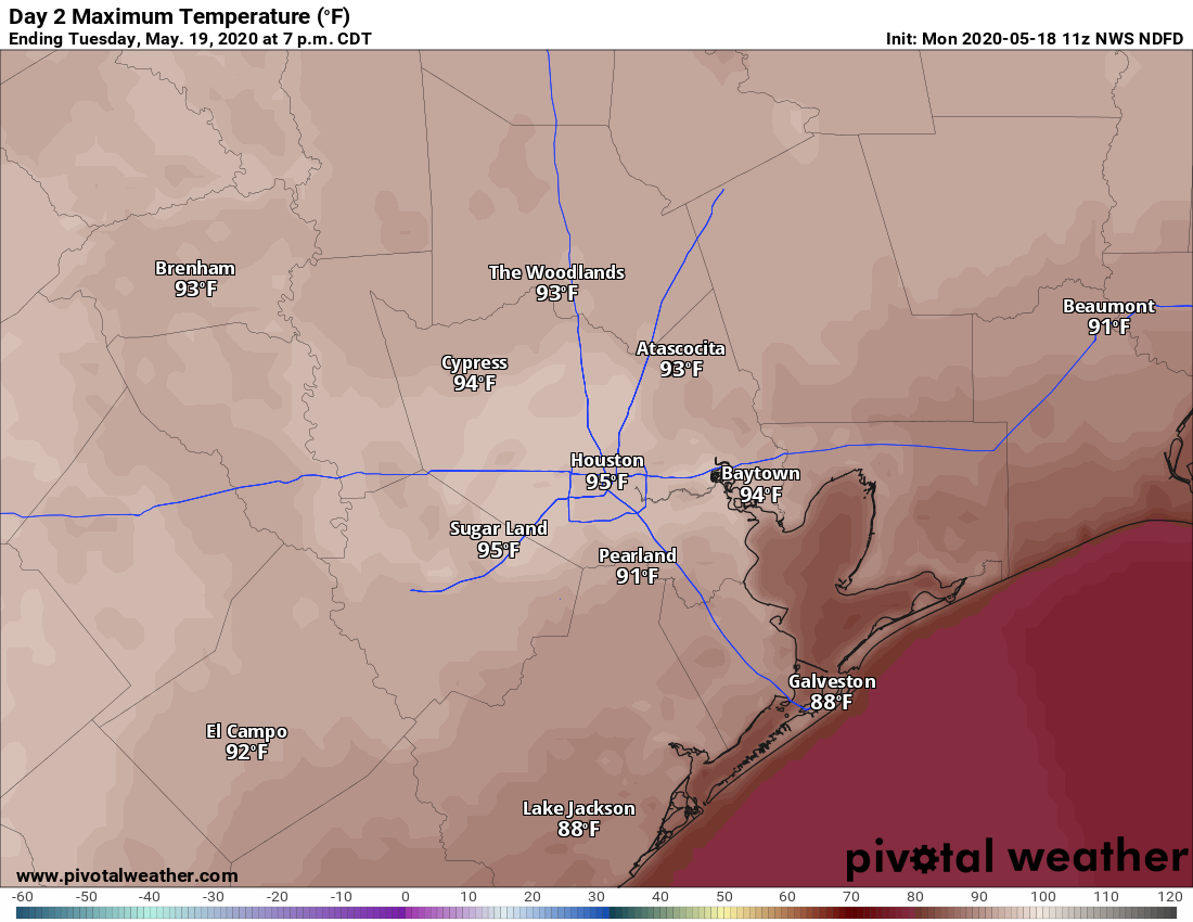
Tuesday’s high temperatures should be the warmest so far of this year. (Pivotal Weather)
Tuesday
This probably will be the warmest day of the week with a warm southwesterly flow and just enough dry air left for temperatures to really pop during the afternoon hours. Expect highs in the mid-90s for much of the city, almost certainly the warmest weather we’ve seen in 2020. Houston’s record high for May 19 is 95 degrees, which is definitely in reach. Make sure to take precautions when outside for extended periods of time.
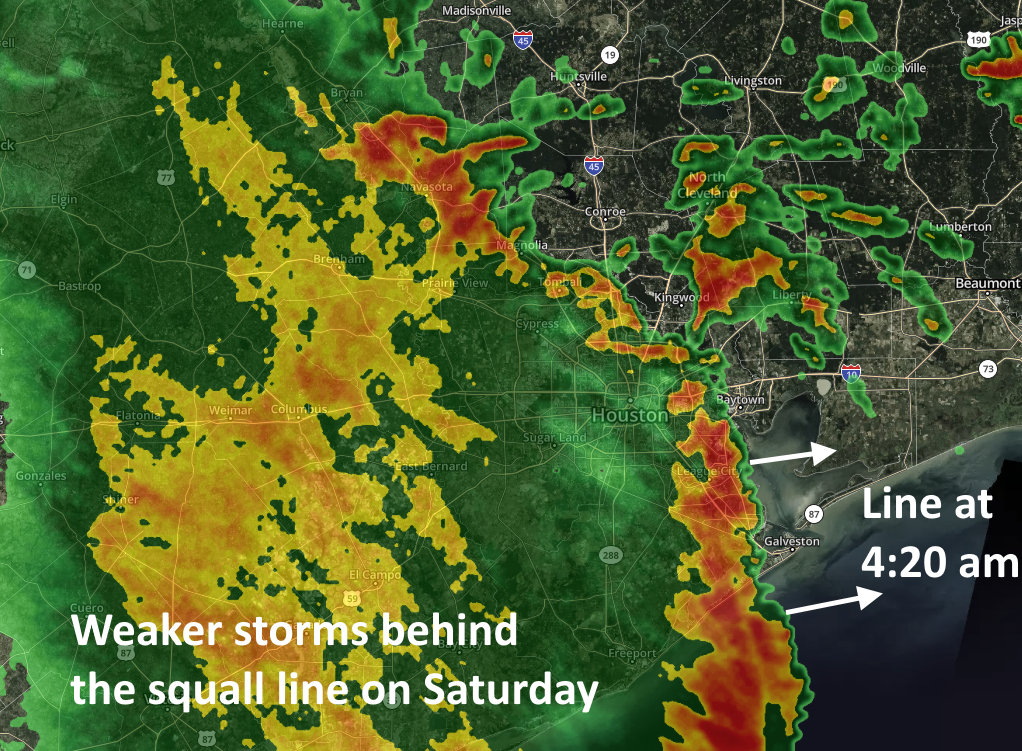
Good morning. After Friday’s unexpectedly widespread storms—with flash flooding in areas such as League City, Seabrook, Kemah, and elsewhere—conditions early Saturday are going more to form. A fairly strong squall line with gusty winds and briefly intense rainfall has pushed through most of the metro area as of 4:30am CT, and it should be well east of the metro area by sunrise. It has generally dropped 0.25 to 0.75 inches of rain.
This should be the worst of the region’s weather, but the upper-level low pressure system we’ve been talking about remains just to the north of our region. This should continue to drive showers and possibly some thunderstorms through the morning hours and into the early afternoon hours. These storms that develop should be weaker and less widespread as they move from west to east. Accumulations following the squall line’s passage should be less than one inch for most parts of the metro area today.
Annotated radar image at 4:20am CT Saturday. (kktv.com)
A lesser chance of showers and storms will persist through the overnight hours and into Sunday. The greater likelihood of development will be over Montgomery County and points north, away from the coast and areas hardest hit on Friday. Sunday should see partly sunny skies in addition to the possibility of some occasional light to moderate showers.
By Monday the drier air should take effect leading to sunnier days and clear nights. This should have the effect of dropping lows into the upper 60s, making for quite pleasant evenings and mornings. Our advice is to enjoy the relatively low humidity while it lasts.
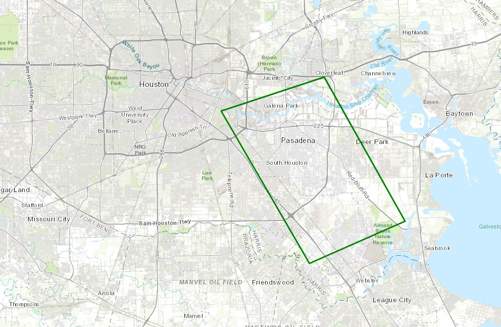
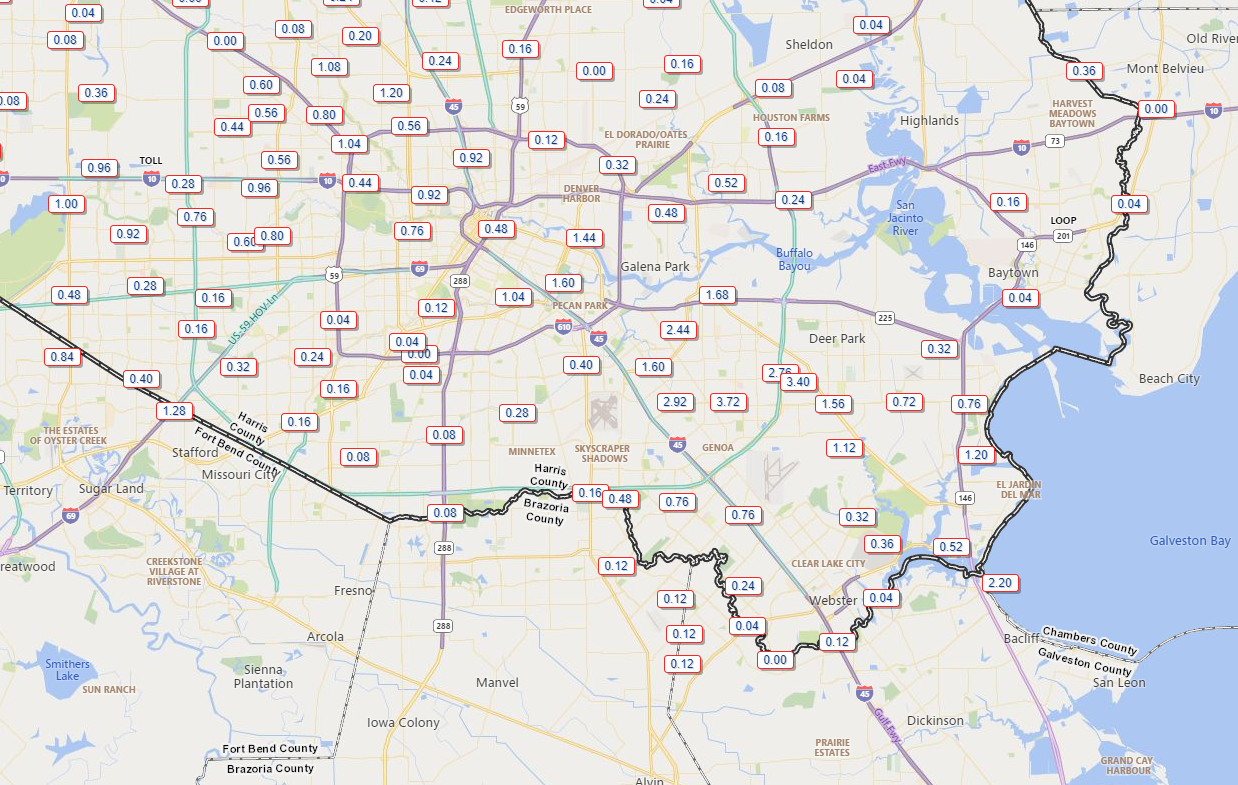
Storms this afternoon were expected to dump heavy rain in a few small areas around the region. What we are seeing is something more robust than that, as widespread heavy rain and some areas of street flooding are ongoing. Flood Advisories are posted for the entire Houston area, and the Pasadena area is now under a Flash Flood Warning through 5:15 PM.
Areas south and east of Houston, including Pasadena have been hardest hit by heavy rain, and a flash flood warning is posted until 5:15 PM there. (NOAA)
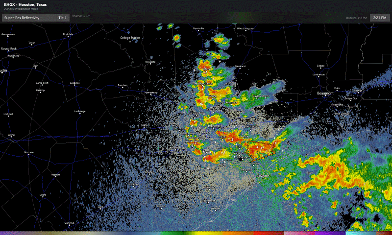
Radar as of 3:15 PM shows a cluster of heavy rain that has migrated west over most of the Houston area.
Radar shows widespread heavy storms in the Houston metro area, with the heaviest rain south and east of the city and also migrating westward. (RadarScope)
This is basically going to need to rain itself out now over the next 3 to 4 hours. Pasadena has been fairly hard hit with nearly 4 inches of rain so far.
Rain totals of nearly 4 inches have occurred so far today near Pasadena. It is still pouring there. (Harris County Flood Control)
For the sake of simplicity I’ve just shown part of the metro area above. You can always check rain totals over various times over the larger area at the fantastic Harris County Flood Control gage site. Some folks will see little to no rain (especially northeast of IAH Airport and perhaps well south toward Lake Jackson and Freeport). Others may tally 5 to 6 inches or more when all is said and done this afternoon.
So heavy rain, storms, and street flooding are likely in many spots through 7 PM. Storms will fade after that. We enter a quiet period later this evening and into the early overnight.
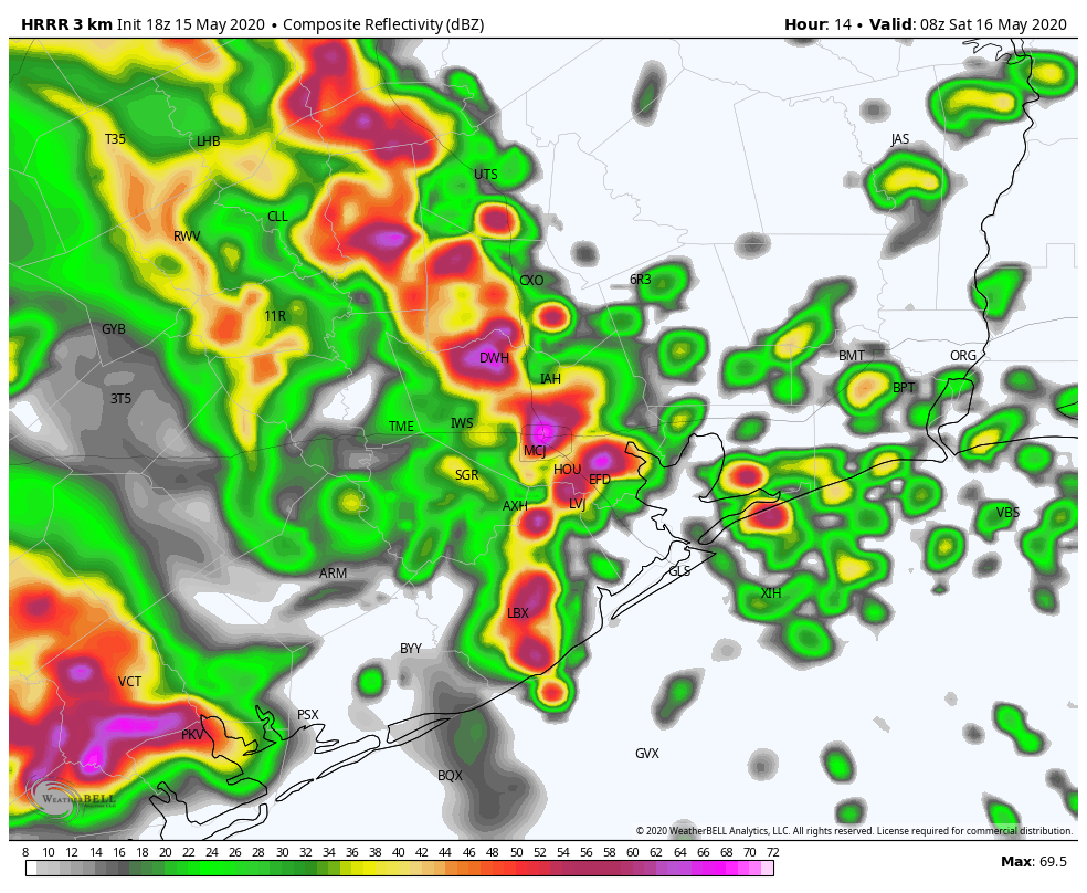
Round 2 of storms will arrive here later in the overnight. The timing of the next wave of storms has sped up since this morning, and it now appears we will see heavy rain and storms resume after 2-3 AM (about 2 to 3 hours faster than expected this morning). Below is what one model thinks radar will look like at 3 AM Saturday.
The HRRR model suggests a large cluster of heavy thunderstorms will plow through the region between 2 and 5 AM Saturday. (Weather Bell)
Other models vary a bit on timing and orientation, but all show the entirety of the region seeing a period of heavy rainfall. Another 1 to 3 inches of rain will be possible with this. This would likely lead to widespread street flooding, especially around the hardest hit areas so far with today’s rains, where the ground will be very saturated.
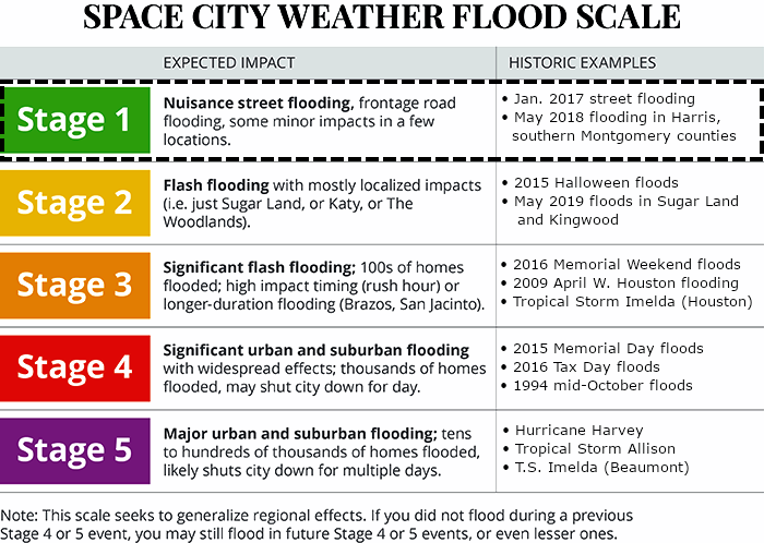
As for Saturday afternoon? There is a chance we see another round of rain and storms, but we still do not have much confidence in details yet to determine whether we need to be concerned or not. We will update you either tonight or early Saturday morning. A reminder that we went with a Stage 1 on our Flood Scale this morning. See our earlier post for more details on that. Stay safe, and remember to never drive through flooded roadways.
On Thursday, we expected a handful of thunderstorms to develop across the area, though it seemed likely most of us would be dry. That’s ultimately what seems to have happened in Southeast Texas, with one very glaring exception.
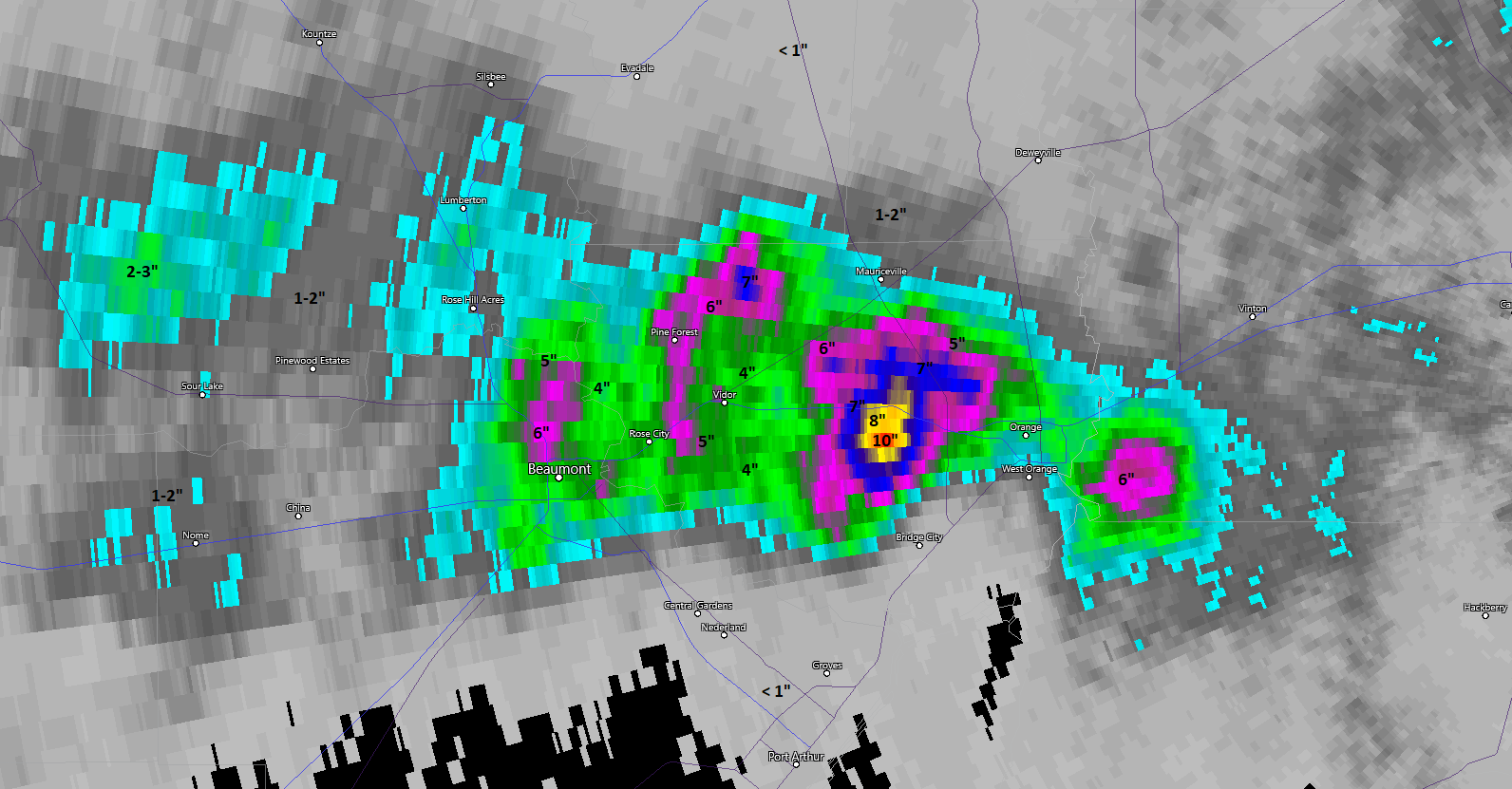
Radar estimates of 8-10″ of rain were observed yesterday east of Beaumont in Orange County. Heavy rain also fell in the Beaumont area. (RadarScope)
The area east of Beaumont, specifically between Vidor and Orange in Orange County was deluged on Thursday with up to 10″ of rain falling near Bridge City. While weather modeling did indicate thunderstorms were possible, none of the models that we saw remotely suggested this amount of rain would fall.
This brings up a key point I like to remind folks of this time of year in Texas: No matter how many models we look at, or how clear we try to be when it comes to forecasting rainfall totals, the reality in Texas is that under the right (wrong?) meteorological conditions, 4, 6, 8, 10 inches of rain can fall on any given location. We are in a very humid air mass, with yesterday’s precipitable water values running 150 to 200% of normal in parts of the region. In English, there was a lot of moisture available to dump heavy rain. Weather models won’t always tell the whole story. If a couple slow moving storms get going, they can easily dump 1 to 3 inches an hour on a location for several hours in this pattern. That’s what unfortunately happened in Orange County yesterday.
We don’t expect that to occur again today, but there will likely be some heavy storms around in a few spots. A Flash Flood Watch has been issued by the National Weather Service for all of the Houston metro area and coast from tonight through Saturday. We are growing somewhat more concerned about Saturday’s potential for widespread street flooding across the area, something that would be akin to a Stage 1 flood event for the area on our Space City Weather flood scale, which we describe in detail here.
Remember, our scale is primarily to set your expectations at a high level for the type of flooding we could see. It’s not a guarantee of what will happen specific to your backyard. We may adjust this later today or tonight as new data warrants.
Summary
The forecast over the next 24 to 36 hours is very complex. Here’s a quick summary of what we’ll go through in detail below:
Today: Most locations see a few passing showers or no rain at all. However, a handful of smaller locations in the Houston metro area have the potential to see slow moving downpours capable of producing 2 to 4 inches or more and flash flooding.
Tonight: Rain ends, then rain chances increase rapidly again after 4 AM, with heavy showers and thunderstorms likely everywhere by sunrise.
Saturday: Heavy morning storms likely with torrential downpours. Street flooding possible, if not likely. Storms should gradually end in the afternoon with a mostly quiet night.
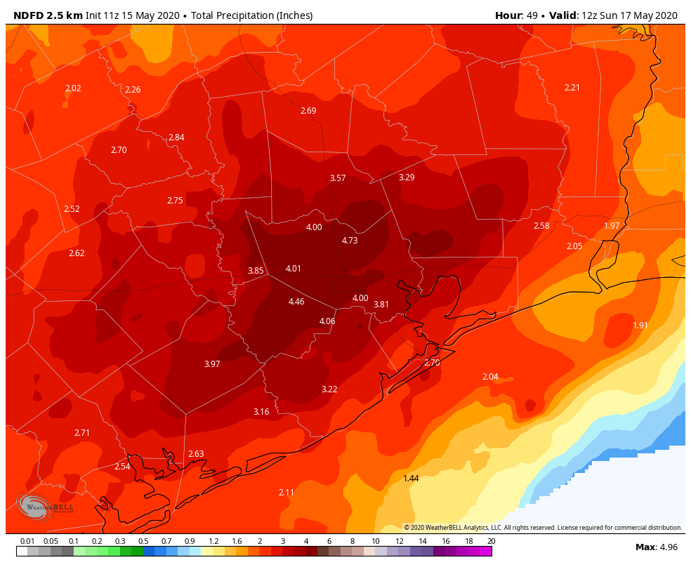
We expect total rainfall to average 1 to 4 inches across the region. There will be many places that come in closer to 1 to 2 inches, but we also expect a couple locations to see perhaps 6 inches or more when all is said and done.
The forecast of total rainfall by Sunday morning will be 1 to 4 inches on average, with a few smaller locations likely to see in excess of 6 inches. (Weather Bell)
Today
Things are quiet this morning, with just a few isolated downpours in the Beaumont-Port Arthur area again.
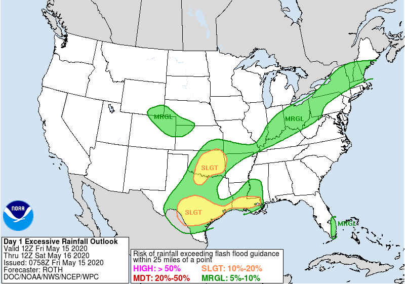
For the Houston area, let’s call it about a 50 percent chance of showers and storms today. The problem today is the same as above in that if any storms develop and drift slowly, we could be talking about some very heavy rain for isolated spots. And some of the higher resolution models we use suggest this is a possibility around Houston. So while many of us will only hear some thunder and see little to no rain, a handful of smaller locations could see 2 to 4 inches of rain or more this afternoon. I don’t want to try and specify where those bigger ticket totals will be exactly, but based on this morning’s model guidance, they would occur somewhere in western Harris, Fort Bend, or Brazoria Counties.The Weather Prediction Center has us in a “Slight Risk” of excessive rainfall today.
A “Slight Risk” of excessive rainfall is shown over Houston today, which means flash flooding is a possibility. (NOAA)
This just underscores that flash flooding is a possibility today.
High temperatures will likely peak in the mid- to upper-80s this afternoon.
Tonight
We expect any lingering showers or storms to end around or just after sunset. Through the first part of the night, things should be quiet. Meanwhile, severe storms in West and Central Texas will likely congeal into an organized complex of thunderstorms and heavy rainfall and work east out of Hill Country overnight. We could begin to see showers develop out in front of that in the last few hours of the night. The general rule is that as we go from this evening to midnight, rain chances dwindle to near zero. From midnight through 6 AM Saturday, rain chances begin to escalate again, rapidly after about 4 AM. Lows will be in the 70s.
Saturday
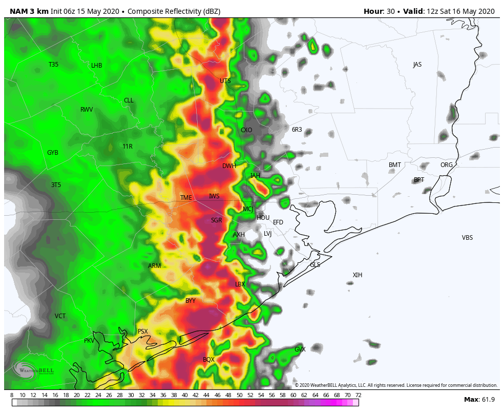
As noted above, the broad summary is that a complex of heavy rain and storms will plow through the entire Houston area on Saturday morning. Some of the storms could be severe, with strong winds being the main concern. But the main concern on Saturday will be street flooding.
One forecast model’s depiction of what radar could look like around 7 AM Saturday shows a complex of strong to severe storms with torrential rain moving across Houston. (Weather Bell)
We should all receive anywhere from 1 to 4 inches of rain with that, though some higher amounts will be possible. Street flooding seems to be a reasonable possibility. Where things would get dicey is if the complex of storms slows down and allows for new storm development or “training” (storms moving over the same areas) on the backside, something we can’t entirely rule out. If that happens, those areas would see another 1 to 3 inches or more of rainfall and more widespread, significant street flooding would become a possibility.
Given how poorly models have performed with specifics historically in these events and how much moisture will be available, I don’t want to try and tell you that we know exactly who will see how much rainfall. We don’t. I expect that we will have a better handle on this later today, and we may post an update this afternoon or evening to clue you into what has changed since this morning.