Good morning. The basic forecast for this week calls for warm weather on Monday before a front sweeps through and keeps the region cool through Friday or Saturday. The notable thing about this front is that, tonight and Tuesday, it will bring our best chance of widespread rain in a month.
Monday
Temperatures on Monday will be quite warm, with highs near 80 degrees under mostly cloudy skies. A southwesterly flow will really pump warmth and moisture into the region, and at the surface we should see winds gusting up to 25 mph. The atmosphere generally will not support rain during the day, but that should change later on Monday night. But before the front arrives, we can expect a warm and humid night, with lows perhaps only dropping into the upper 60s.
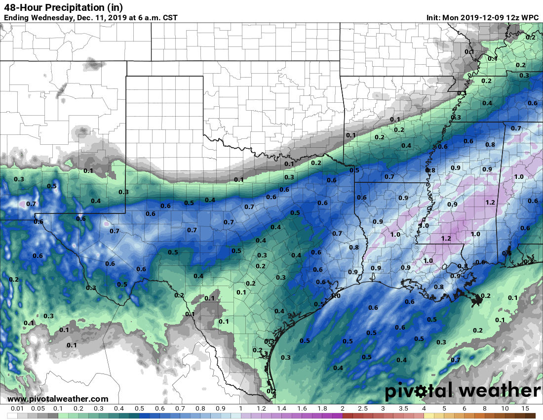
Rain accumulation forecast for now through Tuesday night. (Pivotal Weather)
Tuesday
The cold front should reach far northwestern Harris County by or shortly after midnight, and reach the coast roughly around sunrise. The temperature should drop 10 to 15 degrees in the wake of the front, and highs on Tuesday are likely to fall through the 50s throughout the day. Winds will be quite gusty, out of the north at up to perhaps 30 mph. The front won’t immediately scour moisture from the atmosphere, so we should be left with a gray, wet day—with on-and-off, mostly light to moderate rainfall. Right now, we expect that most people will probably receieve 0.25 to 0.75 inches of rainfall, with a few outliers either way. Rains should end by around sunset on Tuesday.
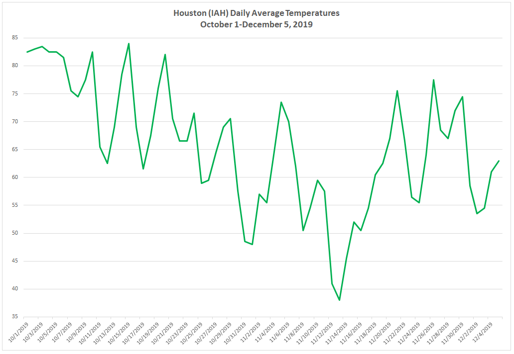
Quick shout out and thank you to Eric for covering me last Friday so I could go home to New Jersey and visit some family. It was cold up there. Had I still been living there, it would have been fine, but after 10 years in southern climes and this amazing autumn in Houston, my tolerance for anything under 40° is gone. This autumn really has been something, hasn’t it? Eric touched on the dry weather this fall yesterday. Let’s look briefly at daily average temperatures this autumn:
Daily average temperatures since October 1st at Bush Airport show an autumn with a lot of cold fronts to reinforce generally pleasant weather. (Space City Weather)
Each time the temperature dips on this chart, it basically indicates that we had a cold front. We’ve had at least 13 of them this autumn. And since mid-October, we have only seen a handful of days with daily average temperatures above 70 degrees. The key this autumn is that the pace of cold fronts has been frequent enough to keep onshore flow rather weak most of the time. So we haven’t had many really muggy days. It’s been virtual Goldilocks weather and one of the nicest seasons I have experienced anywhere that I have lived in my lifetime. And it will continue this weekend.
Today & tonight
Cold front number 14 (at least) of the season will cross through Houston today. We often show you where cold fronts are located based on temperature, humidity, or wind direction change. Today, it’s actually easiest to see the front’s location based on visibility. Ahead of the front, patchy dense fog has developed, especially southwest of Houston or near the water. But you can see roughly where the front is located really well based on where 10 mile visibility shows up.
As of 5:30 AM, you can see the general location of the front based on where visibility improves to 10 miles north and west of Houston. As the front moves through, low clouds and fog will scour out this morning. (NOAA)
The timing of the frontal passage now looks to be between roughly 9 and 11 AM from northwest to southeast across the area. There should not be a big temperature drop behind the front, but you’ll notice that any low clouds and fog will be quickly scoured out. The wind will shift and humidity will begin dropping as well.
Skies will full of sunshine this afternoon. Another winner. We will peak in the 70s later today. Drier air behind the front will allow for a cooler night tonight, with nothing worse than a few passing high clouds. Look for lows to drop back into the low-50s, with perhaps 40s in outlying areas.
Weekend
Saturday should see sunshine and a few passing high clouds. Sunday will see some patchy morning fog, then sunshine and some building clouds. Saturday should top off in the mid- to upper-60s, Saturday night will be back in the 50s, and Sunday will be a little warmer with high temperatures in the low-70s. North winds tonight of 10-20 mph will back off Saturday and especially Sunday.
Sorry, I know these headlines are getting a bit cheesy. But how many ways can you say the weather is going to be be great?
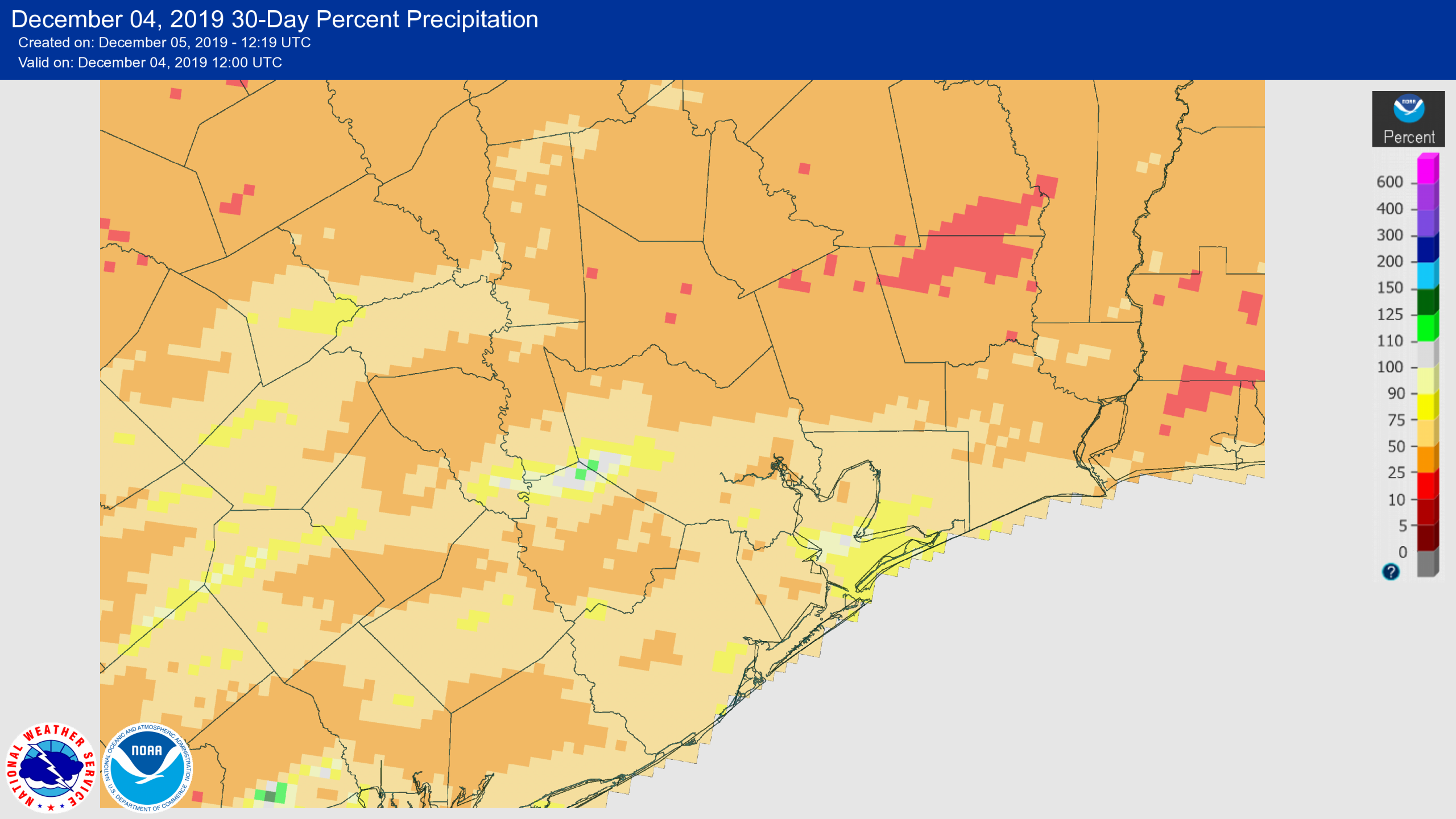
Several readers have noted the region’s dry weather of late, and it’s true that almost the entire area has seen less rainfall than normal since Tropical Storm Imelda in September. The last 30 days—the percent of normal rainfall for this period is shown below—have been particularly dry. There is a reasonable chance that next week will see the return of a decent amount of precipitation, as we’ll discuss below.
Percent of normal rainfall over the last 30 days. (NOAA)
Thursday
Oh noes! For one day this week Houston may not see mostly sunny skies. That day is today. A southeasterly flow will push temperatures up into the 70s today, and bring enough moisture into the atmosphere such that we should see at least partly, if not mostly cloudy skies after this morning. Low temperatures tonight should get down into the low 60s for most.
Friday
After a warmish start during the early morning, a cold front should push into Houston between sunrise and noon. With only a modest amount of moisture return, I would expect most of us to see no rainfall at all, although we can’t entirely rule out a few spotty, very light showers. After the front, skies will clear, and we’ll see a beautiful day in the 70s.
Good morning. Our absolutely splendid weather continues. The only concern today is some dense fog to the southwest of Houston. Some parts of Wharton, Matagorda, and southern Fort Bend Counties are reporting visibilities of less than a quarter of a mile. This fog should clear by or before 9am.
Wednesday
A weak front is pushing through Houston, which will keep our great weather going. Light, northerly winds today will ensure a sunny day, with a high temperature of around 70 degrees. Wednesday night will be partly cloudy, with low temperatures generally in the low 50s. Can you complain about this? I dare you.
A weak front will help keep Wednesday night’s lows on the cool side. (Pivotal Weather)
Thursday
Expect a mix of sunshine and clouds as the onshore flow briefly returns. Highs will likely push into the mid-70s, with somewhat more humid air—but this is still going to be a really nice day for the region. Lows will probably only fall to around 60 degrees ahead of a cold front Friday morning.