We hit 84° officially at IAH yesterday, matching our warmest day of the year so far. These temperatures are more typical for early May than mid-March (and today’s morning lows around 70° are more typical for late May). So for how long will this continue? Let’s explain.
Today through Sunday
Yesterday I mentioned we were pretty much on autopilot, and we are still. For today, we’re slowly losing the fog that’s been with us most mornings this week. Still, some patchy fog at least is possible south and east of Houston. Otherwise, it’s just cloudy. Look for another day of low- to mid-80s with a mix of clouds and sun developing.
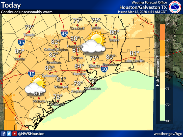
Heading into tomorrow and Sunday, we should still see some patchy morning fog or low clouds giving way to sunshine in the afternoon. We’ll see temperatures within a couple degrees of 80 away from the coast (where it will be somewhat cooler). A shower cannot be ruled out on either Saturday or Sunday, but I think the best chance of any rain will be north of Houston toward The Woodlands or Conroe or even points north from there. Just don’t be shocked if you see some raindrops for a time, especially Sunday.
Sunday night and Monday
Humidity will remain high, but things actually get interesting by late Sunday. One of our better performing models this winter in terms of cold front strength and orientation is suggesting that what we call a “backdoor” cold front is going to slide through the area later Sunday or Sunday evening.
We call it a backdoor front because it usually comes from the north and east, rather than the more common north and west. So what does it mean? Sunday should still be warm and humid, regardless. But if that front sneaks in here late PM or in the evening, we would see temperatures drop off a good 10-15 degrees Sunday night, perhaps into the 50s on Monday morning. The best chance of this occurring would be north of I-10. I don’t think this will make it all the way through the area, and even if it did, it would begin retreating back north as a warm front by Monday afternoon. Still, for those that want even a brief break from the humidity, this would be pleasant. I’d enter this one with low expectations and enjoy a pleasant surprise if you get one on Monday.

 mid-70s early this evening to near 70 by 9 or 10 PM. It will be humid, and it could be a foggy drive home for you, so make sure you’re able to take a little extra time heading home from the rodeo festivities.