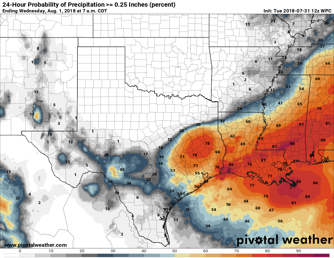
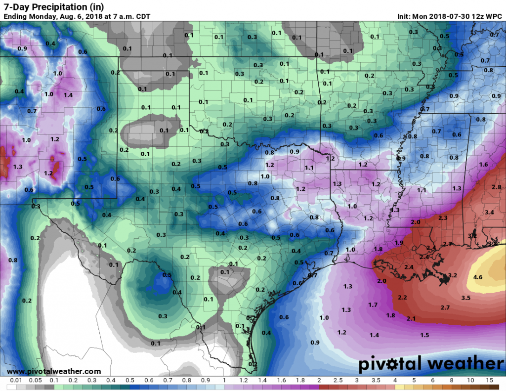
Houston cools down, and the tropics heat up

This post will provide a brief forecast for the Houston area, which really has no weather concerns at all over the next week or 10 days, and then discuss the tropics, where two other storms have developed in addition to Hurricane Irma. With 185-mph winds, Irma continues to pose a grave threat to the Caribbean Islands and southeastern United States—but the forecast is a smidgen brighter for Florida this morning.

The tropics at around 6am CT Wednesday. They are … active. (NOAA)

Houston

Some isolated showers popped up earlier this morning ahead of the cool front, and a few more may develop later this morning and early afternoon as the front moves through the metro area. Nothing to be concerned about. After this we can expect amazing weather through at least Sunday or Monday—with mostly sunny skies, highs in the 80s and lows in the 60s. High temperatures may finally get back up toward 90 degrees by the middle or end of next week, but rain chances will remain near zero.

Irma

The storm’s central pressure has continued to fall this morning (another measurement of intensity) but its winds have held steady at 185mph as it approaches Puerto Rico. The eye of Irma should pass just to the north of the island today. Here’s a look at the official forecast released by the National Hurricane Center at 4am CT:

(National Hurricane Center)

Clearly, this is a devastating forecast for Florida, essentially bringing the storm’s very worst winds and surge to an area from Miami to West Palm Beach. The storm would then continue up Florida’s spine, continuing to deliver punishing winds and waves to the eastern half of the state. However, it is equally important to note that we are discussing a forecast for conditions five days from now. Although hurricane forecasters are pretty good with forecast tracks, the average five-day error is still about 200 to 250 miles in terms of track.

See full post

Three scenarios for Hurricane Irma and the United States

If you’re only interested in Houston weather, you can skip this post. We are not going to see much rain over the next 10 days, and temperatures will generally be pleasantly cool for early September. However, we’ve had a lot of requests from readers to continue coverage of Hurricane Irma, due to the significant threat it presents to the United States. (Already, with winds of 185-mph, the storm is the second-strongest in the Atlantic basin on record). So that’s what we will provide here.

Having looked at the forecast model guidance that has come out during the last two hours, the we can have pretty high confidence in the hurricane’s track through about Friday, when it will be in the vicinity of Turks and Caicos (a beautiful area, which I hope survives this storm). After that I want to highlight three possible scenarios, neither of which I have particularly high confidence in as so many unanswered questions remain: When does Irma find the western periphery of the Atlantic high pressure system and turn north? Does it turn northwest, due north, or northeast? And how much does the storm’s center interact with Cuba? All of these questions will have profound effects.

See full post

Matt: My Harvey story, our call to action for Houston

Harvey was an incredibly emotional forecast that challenged many of us in ways we’ve never been challenged before. In writing this personal retrospective I sought a way to process this experience and convey the emotion of the last couple weeks in words. So this is my story, my call to action, my open letter to the city I’ve come to love.

I grew up in New Jersey and became fascinated by weather, most likely at the age of three. The memories are broken up and fuzzy now, but they’re firmly in my mind. In 1985, Hurricane Gloria came barreling up the Eastern Seaboard, forcing my family to evacuate my grandmother from her home in Atlantic City. My dad taped up windows around our house about four miles inland from the shore. I remember going to the coast after dark as the storm pulled away to (perhaps my parents would now admit, unwisely) “assess damage” to the beach. Gloria’s impacts on the Jersey Shore were modest. My grandmother’s house was unscathed, and life got back to normal in short order. Somewhere along the line Gloria ignited a passion for meteorology. It started with a hurricane in New Jersey, and as I sit here 32 years later, I openly wonder if a rain-laden hurricane in Texas is what extinguishes it.

Boardwalk damage in Ocean City, New Jersey from Hurricane Gloria. (Wikipedia)

I’ve dealt with a few stressful forecasts in my career. There have been blizzards when I worked in Upstate New York. Hurricane Irene in 2011 had me considering telling my parents to evacuate the same home we shored up for Gloria. In 2012 came Sandy. I had many friends and family members back in Jersey and New York directly impacted by that storm. The lead-up to that storm was one of the most stressful I’ve dealt with, though now a fading second to Harvey. At the time I worked as a meteorologist for the energy trading arm of Deutsche Bank here in Houston. My boss was on a required two week leave, and the onus fell on me to prepare our New York City office for Sandy’s impacts. I remember conference calls, and giving a worst-case scenario forecast I didn’t really even grasp. Sandy was the storm that, as a passionate weather geek, I drew on a map as a kid that wasn’t ever supposed to happen. It was difficult to see the Jersey Shore, my homeland, so ravaged. But my life had brought me to Houston by then, so there was a buffer there to reduce the storm’s emotional impact. But it remained difficult to watch.

Life had indeed brought me and my wife to Houston. We moved here in 2012 after stops in Jacksonville, Southern California, and Upstate New York. Maybe it’s because I somehow grew up deep in Philadelphia Eagles territory as a Warren Moon and Houston Oilers fan (not kidding here at all, I have the 1990s-era Starter jacket to prove it), but I have always had an affinity for Houston. I had no family here, and the first time I visited was on a job interview in 2008. As a broadcast meteorologist in Upstate New York, I had decided that the route I wanted to steer my career toward involved the energy industry. After discussing it over a long period of time with my wife (then fiancée), we decided that Houston would be our goal. It took a few more years, but we arrived in 2012, a year or so after my wife’s brother moved here. My wife’s parents wouldn’t be far behind. Houston didn’t become a home. It became our home.

See full post

Cold front coming, and Hurricane Irma reaches Cat. 5 status

A cold front remains on track to reach Houston on Wednesday, arriving a couple of weeks early to the region, and bringing some genuinely fall-like weather to the upper Texas coast. I’ll also discuss Hurricane Irma, because the storm has reached Category 5 status and almost certainly will have some devastating effects in the United States. We remain pretty confident the storm won’t have major effects for Texas, however.

Tuesday

We’ll still be pretty warm today, with highs in the low 90s across Houston, but for early September this is still decent weather. Houston could see some scattered showers later this afternoon, but for the most part we should be rain-free.

Wednesday

Cold front day! It’s almost like a holiday here in Houston. Moisture levels will increase a bit before the front moves through on Wednesday, most likely during the late morning or early afternoon hours. Some scattered showers are possible with the front—a few isolated areas could see as much as half an inch of rain—but for the most part this should be a breezy passage rather than one with thunder and lightning. Humidity should fall off a cliff after the front moves through, making for a pleasant evening.

Forecast map showing dewpoint temperatures on Wednesday morning. The front is almost to Houston. (Weather Bell)

Thursday through Sunday

We’ll have some great September weather after the front comes through, with highs generally in the mid- to upper-80s, overnight lows in the 60s (perhaps upper 50s for some inland areas and closer to 70 degrees along the coast). The drier air and full sunshine will feel fine.

See full post