On Sunday, the high temperature at Bush Intercontinental Airport reached 91 degrees. This came to within one degree of the all-time record for Oct. 14, set in 2015. We can consider this the last hurrah of summer for 2018, as fall will more fully assert control this week, and seems unlikely to relinquish its grip completely in the weeks ahead. I can confidently predict that we will see no more 90-degree temperatures this year given the overall cooler outlook for the next two weeks. (The latest 90-degree day on record in Houston came on Oct. 29, 1991).
Monday
Today, our weather will make a dramatic shift from summer into serious fall-like conditions. By 7am a cold front had already pushed through northern areas such as Huntsville and Conroe, and should move off the coast by around noon today. What will follow can probably be best described as Seattle-like conditions, as temperatures fall from the mid-70s this morning across the region into the 60s this afternoon, and 50s tonight.
This will not be a classic blue-norther front, as the cold air mass is rather shallow, and this will allow plenty of clouds to form a few thousand feet up in the atmosphere, and this essentially means that we’ll have on-and-off rain showers later Monday, Monday night, and Tuesday.
Tuesday
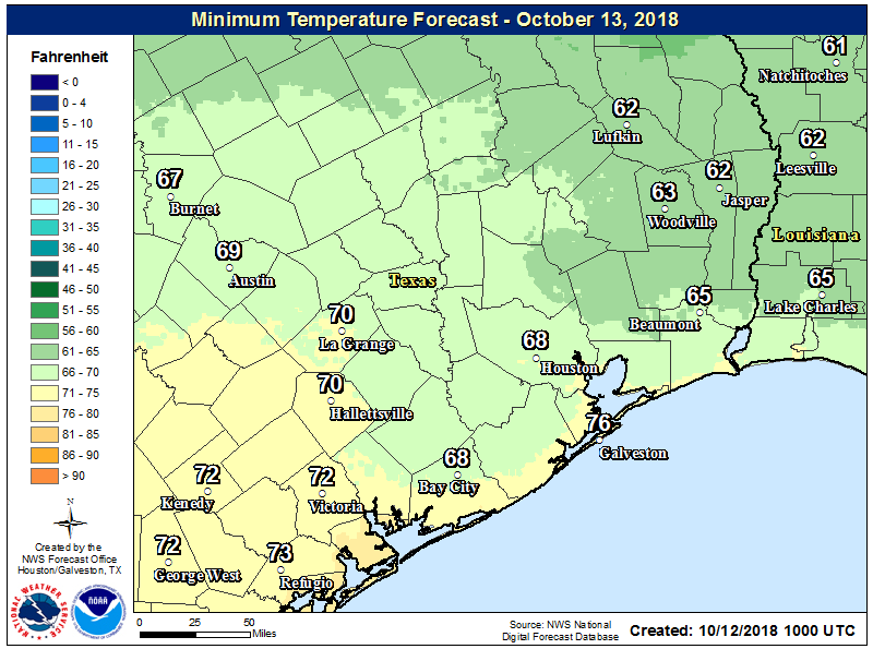
Houston’s last high temperature of 60 degrees, or below, came back on April 8 when a strong cold front hit the region. A portion of the region may not reach 60 on Tuesday, as clouds blanket the region with intermittent rainfall.
We may see some brief, localized heavy showers but for the most part rain amounts will be completely manageable. Conditions will be dreary out. Fireplaces may be needed inside. Dare I say it will feel almost winter-like out there?