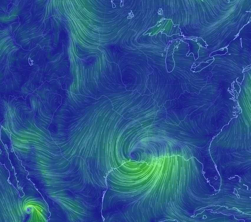
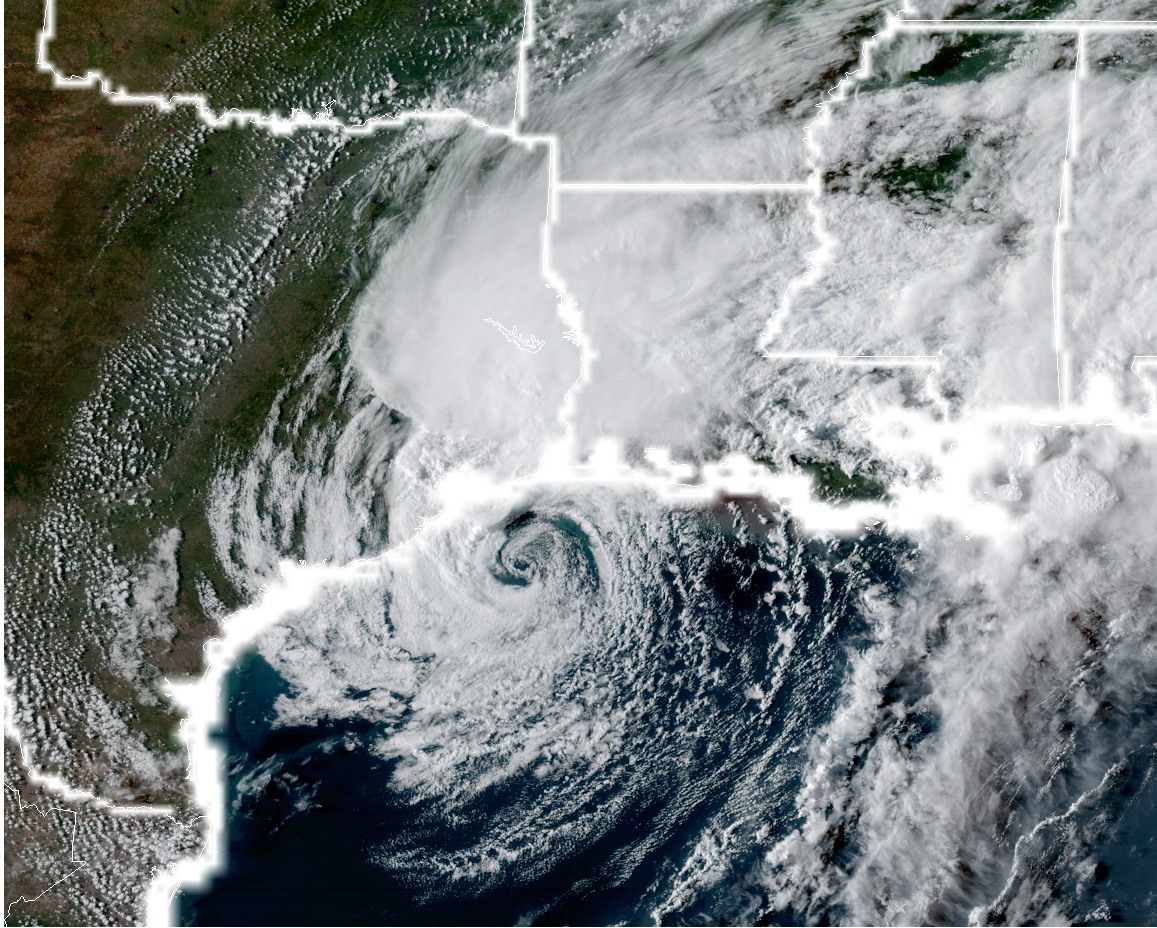
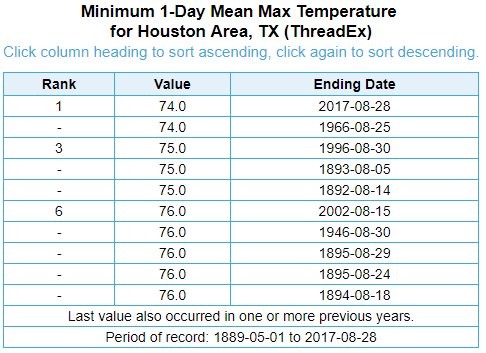
Houston Marathon forecast at 12 days: Grim, but not without hope

I lacked the heart to post an update this morning about weather conditions for the 2017 Houston Marathon because, well, the forecast was really rather grim. Grim as in warm—or perhaps even really warm with race time conditions in the 60s, rising into the 70s. I’d hoped that maybe, just maybe, the 12z models that came out this afternoon would offer some hope for a cooler race day.

I’m happy to report that the outlook is a tiny bit better.

As ever there is extreme caution required when considering long-range forecasts, especially at 12 days out. However temperatures in winter are a little bit easier to forecast than, say, a hurricane. That’s because a hurricane is a relatively small meteorological phenomenon, which can be perturbed by relatively small changes. Temperatures are largely controlled by very large upper-air patterns, which are a little bit more predictable. And in this case the global models are showing a rather large area of high pressure building over the United States next week, for much of the central and eastern United States. This will bring temperatures up.

If you click the graphic below (which shows the GFS model forecast for daily temperature anomalies for the next 16 days) to enlarge it, it should make a little more sense.

As high pressure builds next week, so does the warmth toward the end of next week, as shown in this GFS forecast for temperatures in the lower levels of the atmosphere. (Weather Bell)

(Space City Weather is sponsored by Westbury Christian School for this month)

See full post

Major cooldown on tap for Houston this week

Houston’s weather has quieted down after Monday morning’s severe thunderstorms, which brought generally 0.25 to 2 inches of rain to the entire metro area. This map shows the heaviest accumulations just to the northwest of Houston:

Rainfall totals on Monday for the Houston area. (National Weather Service)


And although December may have ended on a warm note, with five of the last eight days seeing highs of 80 degrees or greater, a cooler start to the month kept the average temperature to 58.6 degrees. This was cool enough to finish just outside the top 10 warmest Decembers on record for Houston.

Today

It’s noticeably cooler this morning, as lows have generally fallen into the 50s across the region. Houston will warm up considerably this afternoon under mostly sunny skies as winds are already blowing in from the southwest at 5 to 10 mph, and this should allow highs to climb into the mid-70s. But another, likely dry front will move through this afternoon, putting the kibosh on any significant warming this week. Lows tonight should fall into the 40s, except for immediately along the coast.

(Space City Weather is sponsored by Westbury Christian School for this month)

See full post

2017 Houston Marathon weather forecast: 13 days to go

For most of us running the upcoming Houston marathon on January 15th we had our last, semi-long run this past weekend, and it’s time to taper down to the main event. We’ve trained. We’ve worked hard. And now we’re at the mercy of Mother Nature. So let’s discuss what’s in store.

When it comes to forecasting weather conditions nearly two weeks out it’s important to remember that forecast models have limited accuracy after about 10 days. Perhaps the best way to gauge conditions from this far out is to look at the ensemble runs of global forecast models. That is, the GFS and European models are each run about 50 different times with slightly different starting conditions. This gives a range of outcomes, and from looking at all of these ensemble runs we can get some probabilities on conditions.

(Space City Weather is sponsored by Westbury Christian School for this month)

See full post

After storms this morning, turning cool and then colder this week in Houston

Houston welcomed the New Year with some severe thunderstorms moving through the area on Monday morning. Although some embedded storms were quite heavy, as they moved quickly there was little time for floodwaters to accumulate. The primary threat came from winds, with a few gusts reaching 60 mph to the north of Interstate 10. An additional line of storms will move through before 10am CT, but then we’re going to clear out. A couple of cool fronts will bring temperatures down this week, but there’s still a fair amount of uncertainty about how much colder conditions will get this weekend.

Today

After the storms clear out winds should pick up out of the west, bringing some drier air into the region and allowing overnight lows to slide down into the 50s—lower 50s up north and upper-50s closer to the coast. Before that happens a sunny afternoon should allow highs to reach near 80 degrees, however.

Tuesday

A rather pleasant day. Humidity levels will be lower with more westerly winds, and highs should climb into the 70s under mostly sunny skies. A cool front will arrive around sunset, give or take a few hours, and it should be a dry passage. This should push overnight lows into the upper 40s for most of Houston.

Wednesday and Thursday

Conditions will feel more winter-like with northwesterly winds. Under partly to mostly sunny skies expect highs of around 60 degrees, with lows in the 40s.

(Space City Weather is sponsored by Westbury Christian School in January)

See full post