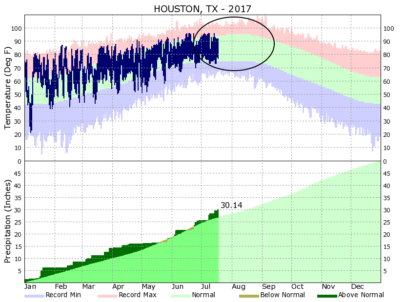
We’ve reached the dog days of summer, and it sure feels like it across Houston. Traditionally the period of mid-July through the end of August is the warmest period for the region, with average high temperatures around 95 degrees, and overnight lows in the mid- to upper-70s. We’re now in that stretch of weather, and barring heavy rainstorms daily temperatures will be sizzling for the next six weeks or so. If we all hold hands, we just might make it to fall, because it’s not so terribly far away now.
We’re now in the warmest time of year for Houston. (National Weather Service)
Today
High pressure has begun to build to the north of the region, but there’s enough moisture near the coast to still produce some isolated downpours south of Interstate 10. For the most part, however, expect partly sunny skies, scattered light to moderate rain showers, and highs in the low to mid-90s.
Houston is beginning to transition from a period when some areas of town were almost guaranteed to see downpours on any given day to that of more typical summertime weather, when light-to-moderate showers most commonly form along the sea breeze, during the afternoon and evening hours. We’re not quite there yet, however.
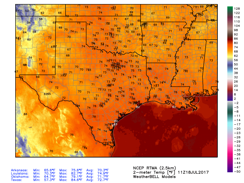
Temperatures are normal for this time of year across Texas. (Weather Bell)
Tuesday and Wednesday
Some potential for localized, very heavy rainfall will linger for the next couple of days, especially closer to the coast. This means if you’re under one of the bullseyes you could quickly pick up 1 to 2 inches of rainfall. Otherwise, you’ll probably see only brief showers or partly sunny skies. Highs may reach the mid-90s for sunny areas, while temperatures closer to the coast remain around 90 degrees. Regardless, it will feel warm and humid.
Mother Nature spared much of the Houston metro area rainfall on Sunday, however with a very moist atmosphere in place we can expect a chance of episodic heavy rainfall for at least the first half of the coming week. This is what happens in July in Houston when there is no high pressure or capping inversion to inhibit tropical rain showers.
Monday, Tuesday and Wednesday
Moisture levels are quite high in the atmosphere, with precipitable water values at 2.0 to 2.2 inches across the region. This means that if you measured the volume of water between the surface and outer space of a certain column of atmosphere, it would have a depth of around 2 inches. This is a lot, and tends to produce rainfall when there are no factors to stop it. For the start of this week there aren’t any—and in fact the upper-level atmosphere favors the development of some storms.
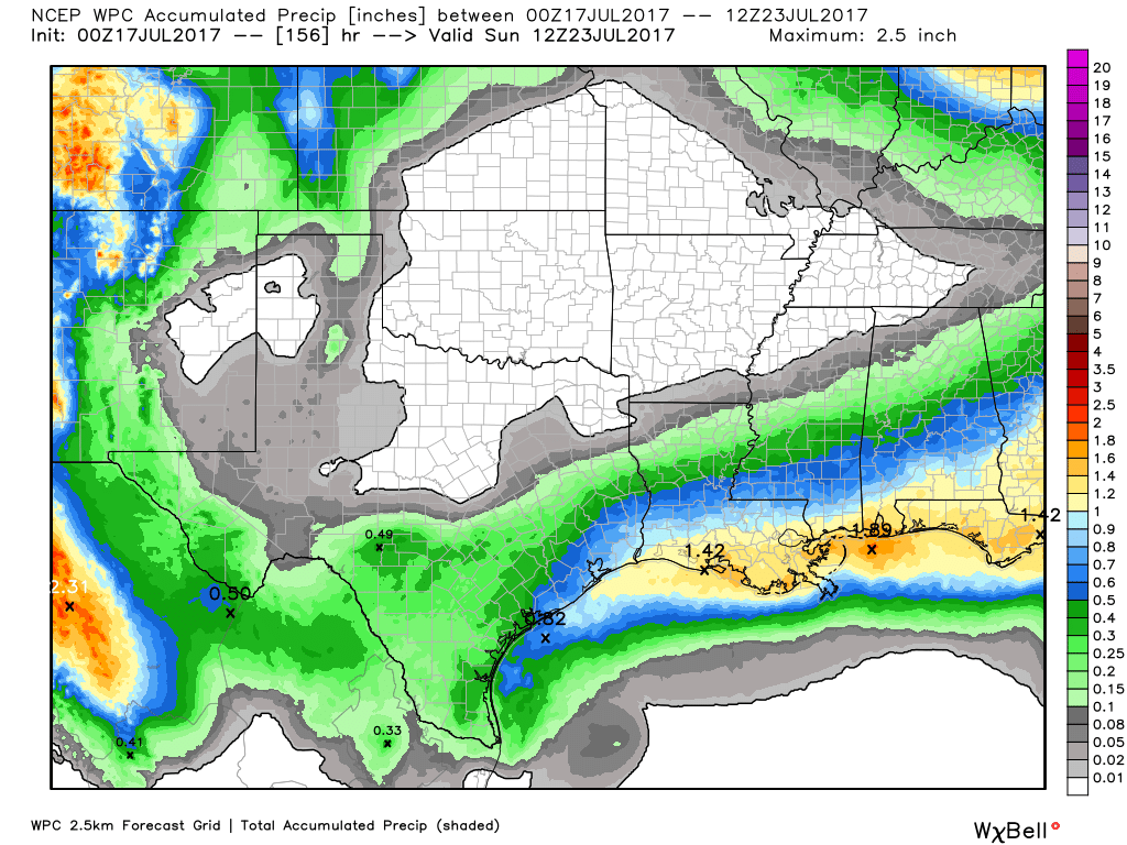
On average Houston should get 0.5-1.5 inches of rain this week, but some areas will see quite a bit more. (Weather Bell/NOAA)
So what does this mean? We’re going to continue to see some potentially stormy days. Last week we talked about how some areas will see mostly sunny skies, some areas mostly gray skies, and some areas will get slow-moving tropical showers. That pattern will continue through Tuesday or Wednesday of this week, with some areas getting 2 to 3 inches of rain in a couple of hours, and others none. Rain chances are likely to be higher (around 50 percent) closer to the coast during the morning, and then the best chances will migrate inland during the afternoon and evening hours. Heavy rains and lightning are the primary threats. The upside of potentially stormy days is that they should limit highs to around 90 degrees.
It’s both a blessing and a curse as a meteorologist to live somewhere that you could almost set a clock to the weather each day. Predictability is great, but they say variety is the spice of life. Houston’s weather has been nothing if not persistent recently. And it looks to continue heading into the next several days.
Today
I don’t see a ton of difference between today and any other day we’ve had this week really. But there are enough subtle differences to make me fairly confident we see more showers around today than we did yesterday. Precipitable water (“PWAT,” a measurement of how much moisture is available in the atmosphere) is flat or down just a bit today versus where it was on Thursday in Houston. PWAT remains elevated north of The Woodlands and east into Louisiana today. While it could rain anywhere as we go into this afternoon, the best odds of cooling downpours will probably be near the coast or Galveston Bay this morning and east of I-45 or well north this afternoon. But regardless of where you’ll be in the Houston area, have an umbrella at the ready today.
Here’s a model derived radar forecast from 12 PM-8 PM today showing widely scattered showers flaring up, especially east of I-45 and to the north of Houston. But that certainly won’t exempt Houston from storm chances today! (Texas Tech)
Temperatures will range from the low to mid-90s where rain is minimal to the upper 80s or lower 90s where downpours are more persistent.