Warmer now through Friday, before another cold front this weekend

It’s chilly again this morning — generally in the upper 30s across the Houston metro area. After another cold start to today we’ll warm up until this weekend.

TODAY and WEDNESDAY

Both days should bring mostly sunny skies, with highs in the low 60s. Temperatures tonight will fall to around 40 degrees, and as clouds return on Wednesday night temperatures will only drop into the low 50s.

THURSDAY

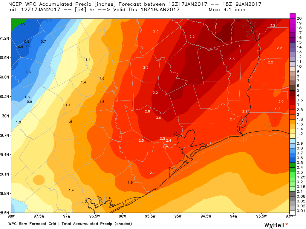
Increasing clouds on Wednesday night and Thursday morning will herald the return of higher moisture levels, and an upper-level disturbance will move overheadĀ the area later on Thursday. Still, conditions for severe storms aren’t good, and much of the region should only see only modest accumulations of rain. Chances are best along the coast.

Rain accumulation forecast for Thursday and Thursday night. (Weather Bell)

See full post

Six days before the Houston Marathon the forecast looks great

The forecast for the Houston Marathon remains more or less the same as I’ve been describing over the last several days. We’re likely to have excellent conditions for long-distance running.

It still appears as though a cool front will push through Houston on Friday or early Saturday morning, setting the stage for clear, cool conditions on Sunday morning. Pinning down exact temperatures at six days out is still not possible, but I feel fairly confident in predicting a range of between 35 and 45 degrees on the start line, increasing to the low 50s by the end of the race.

The 18z GFS model is probably on the low end of possible temperatures for Sunday morning. (Weather Bell)
The 18z GFS model is on the low end of possible temperatures for Sunday morning. (Weather Bell)

See full post

Houston records first freeze, but will slowly warm up this week

Houston officially recorded its first freeze of the 2015-2016 winter this morning. As I wrote recently, this is the latest freeze on record in Houston since 1965-1966, and more than five weeks later than the average first freeze at Bush Intercontinental Airport.

TODAY and TUESDAY

We’ll slowly begin to warm up now, with highs in the mid-50s today and around 60 on Tuesday, along with mostly sunny skies. Lows will be cold at around 40 degrees, but not near freezing in the Houston metro area.

WEDNESDAY and THURSDAY

Clouds return, and eventually some decent rain chances. The best chances for rain will come from Wednesday afternoon through Thursday evening, and along the coast, as a disturbance moves overhead. Still, I don’t anticipate severe weather or that much rain.

For the most part the Houston region should see only modest rain accumulations this week. (Weather Bell)
The Houston region should see only modest rain accumulations this week. (Weather Bell)

See full post

With less than a week to go, sunny and cold conditions most likely for Houston marathon

Less than a week to go now until the start of the marathon, and we’re getting closer to nailing down the forecast, too. The global forecast models are coming into better agreement about the timing of a cold front — likely sometime on Friday or early Saturday morning. This would set up clear and cool conditions for Sunday morning.

Now the usual caveats apply, a forecast made seven days out is going to have some element of uncertainty. But both the European and Canadian models have been fairly consistent with this scenario, and now the GFS model has come into line. Therefore I am beginning to have a decent amount of confidence in colder-than-normal conditions for the morning of the marathon, with low temperatures that morning between 30 and 40 degrees, most likely.

Canadian model forecast for temperatures on Sunday, at 6 a.m. (Weather Bell)

See full post