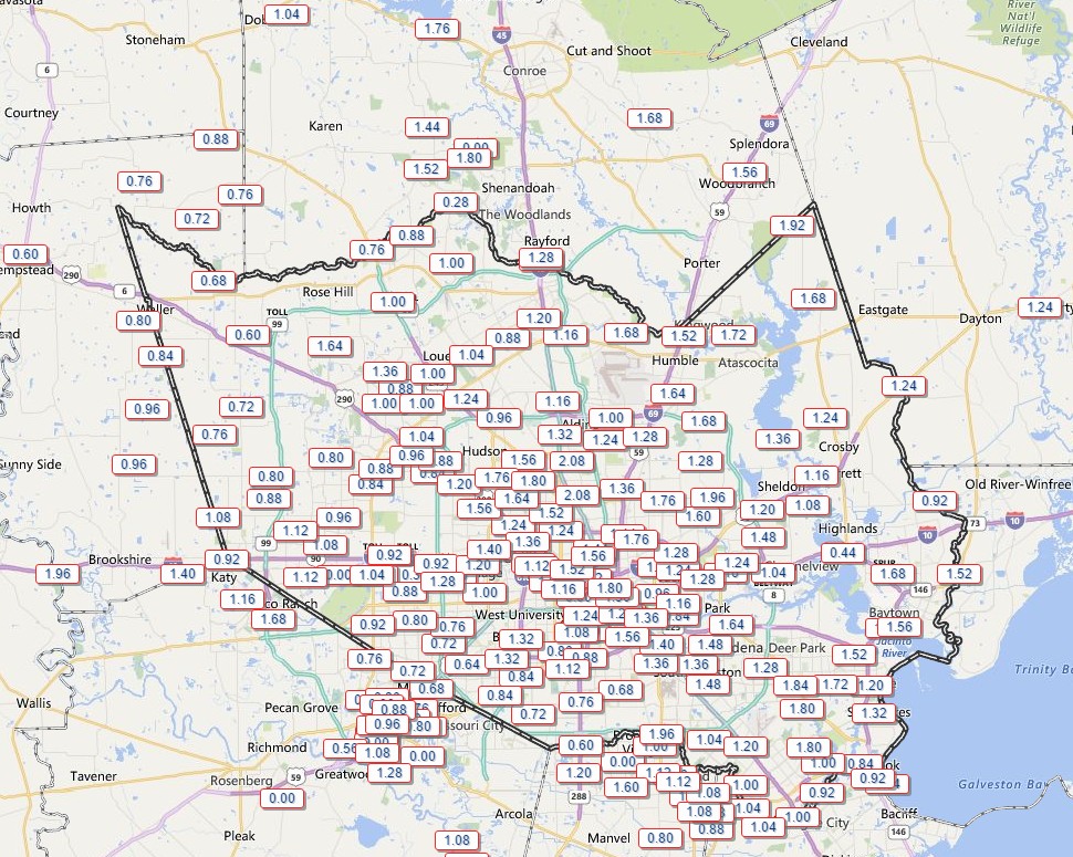
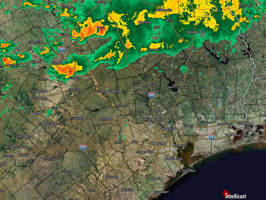
Not only is winter gone, summer comes this week!

Some of you have lamented the early demise of winter this year—Houston hasn’t had a low temperature below 47 degrees this month—and I don’t have any better news this week. Temperatures are going to warm up into the upper 80s on Monday and Tuesday, possibly reaching 90 degrees on Monday in some locations. Here’s a quick discussion of why:

An area of low pressure over Nebraska will direct winds over Texas to flow from the southwest later on Sunday and through Monday. In the chart below winds (blue hues depict a stronger flow) are shown about 3,000 feet above the surface of the Earth.

A
Winds and air pressures at the 900 mb level on Monday evening. (Weather Bell)

See full post

Excellent site news!

As most of you know this site has experienced some server stability issues during the last couple of months. That’s due primarily to my poor choice of a hosting service, and general lack of webmastering abilities. It’s definitely not acceptable, especially with the spring storm season on the horizon, and hurricane season coming along in just a few months.

Fortunately an old friend has stepped in to help, Jeff Balke of Two Roads Media. I’ve known Jeff for 15 years now. We met way back when the Houston Rockets were in the midst of their second campaign to secure funding for a new arena, I was covering the story, and Jeff had founded Save Our Rockets. Well, the Rockets got their arena, but we’re still waiting on that third championship, Jeff!

In any case Jeff helped me find a much better hosting service and we’ve moved the entire site over there. From here on out there should be no server stability issues, and he’s agreed to ensure that’s the case. Seeing that he’s also a weather nerd he may make contributions to this site from time to time, especially during hurricane season.

Almost finished with the rain risks

Eric touched on the flooding issues for our friends to the east in the Sabine River basin yesterday. Check that post and visit the NWS Lake Charles website for the latest. Locally, here are the latest flood gauge levels and forecasts around Houston.

We got away with a mostly quiet Thursday. Judging by the weather model trends, today will hopefully have a similar outcome.

TODAY

The upper low over Mexico the last couple days is projected to end up over South Central Texas this afternoon. That means we are slowly drawing closer to the end of this frustrating weather pattern.

Upper level low moves over South Texas this afternoon and evening. (Weather Bell)


There will still be a few spokes of energy pivoting around the upper low today, so we will still carry a chance of showers or a thunderstorm throughout the day (showers this morning are popping up west of Houston already). But the heaviest storms will be in Eastern Louisiana and Mississippi. There will also likely be areas of showers/storms on the periphery of the upper low in interior Texas (basically north, west, and south of us). That puts us in between. So I’ll put an optimistic spin on things and say, “Yes, a chance of showers or storms through the day today, but I will lean toward the bulk of the day not being too bad.” We’ll see if that works out.

See full post

Houston escapes major flooding, but Sabine River facing historic rises

As expected the rains have moved out of the greater Houston region, and the heaviest storms are now over central Louisiana. Although a flood warning is in effect for Cypress Creek today in Harris County, only minor flooding is expected for portions of Sharp Road and Katy Hockley, which will may become inundated and possibly impassable later today or tonight.

The story is different to our east. Take a look at the total rainfall received in the Texas-Arkansas-Louisiana area during the last 48 hours. Note the very large area of 12 to 15 inches of rainfall in the Barney-colored purples.

Rainfall accumulation during the last 48 hours. (National Weather Service/Weather Bell)

See full post