The mountainous terrain of Mexico has shredded the once incredibly powerful Hurricane Patricia, and the system is now a tropical storm as it races northeast toward its soggy destiny with Texas. Patricia will combine with a slow moving cool front and ample Gulf moisture to create a potentially dangerous situation tonight in the greater Houston area.
RAIN ACCUMULATION
Forecast models continue to predict an extreme rainfall event for the Lone Star State, and it appears increasingly likely the heaviest precipitation today and Sunday will come along the upper Texas coast. To start with, here’s the latest precipitation forecast from NOAA’s Weather Prediction Center, essentially the best estimates from their meteorologists assessing all of the models for rain between this morning and the end of the event on Sunday night:

The first thing you’ll probably notice is a staggering 11-inch bullseye over Galveston County and Galveston Bay. This indicates the kind of very, very heavy rain this system and its associated tropical air mass are capable of.
I would not focus solely on the bullseye, however. This system has the capability to produce large amounts of rain over a large area, including the entire Houston region, from Conroe to Sealy and all points in between. With that said, most forecast model suggest the very heaviest rains of 10, 12 or more inches will come closer to the coast. The area below reflects where I believe the heaviest rain is likely to come.
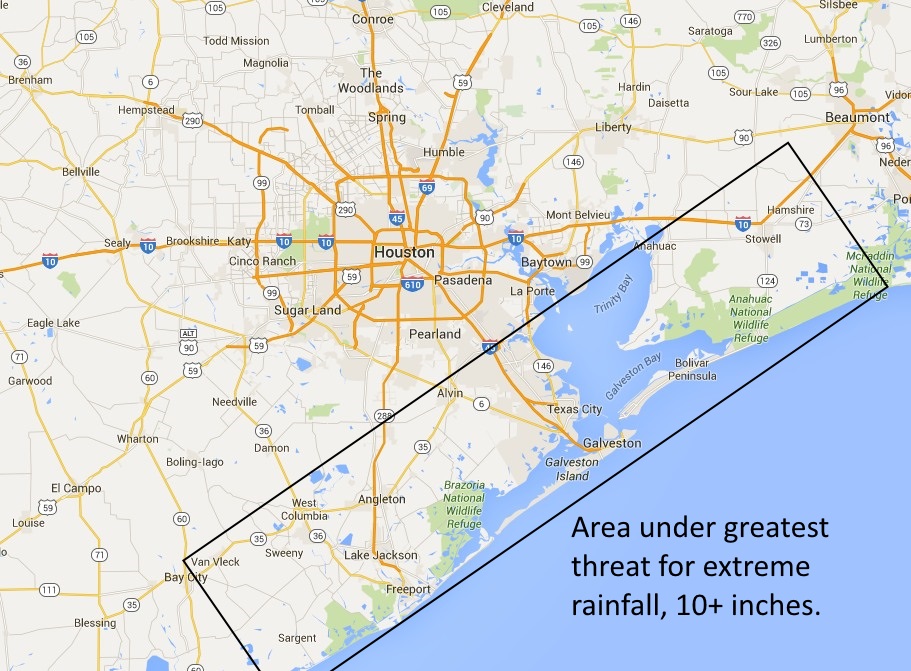
Regardless, much of the metro area should count on seeing widespread totals of 5 to 10 inches during the next 36 hours.
FLOODING
Most areas of Houston can handle six to eight inches of rainfall spread over a couple of days. The problem is that this air mass is so moist it could bring rainfall rates in excess of 3 or 4 inches per hour. That exceeds the capability of most drainage systems and area bayous and streets will fill up quickly.
The entire Houston metro area is under a flash flood watch through Monday morning, and expect the area to be upgraded to flash flood warnings by later today. If you can avoid traveling, working or otherwise being away from your home this afternoon through Sunday evening, you should do so.
TIMING
Until about noon the heaviest rains should remain well to the northwest and southwest of Houston, allowing for last minute preparations.
Beginning about noon I expect a core of very heavy rainfall to move up the Texas coast, from southwest to northeast. Here’s a map I made to show the approximate movement of this core of heaviest rains. It is not gospel, but rather an estimate of when areas might expect rainfall rates of 3 to 4 inches per hour.
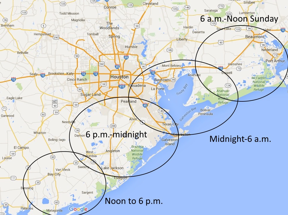
If there is any good news it’s that the system should not linger. I expect the heavy rains to clear out of the metro area, from west to east, between noon and about 10 p.m. on Sunday.
TIDES AND WINDS
The associated swells with the remnants of Patricia will increase tide levels by several feet tonight, which should be enough to cause coastal flooding in low-lying areas, including Bolivar, West Galveston Island, Seabrook and the shores of Clear Lake. Tides should fall off by the middle of Sunday.
Winds could get testy too, especially along the coast. Gusts up to 50 mph or so are possible. This is one more reason to remain indoors through the middle of Sunday, until the rains pass.
FUTURE UPDATES
I will update this blog around 1 p.m. today.
Finally, you can follow me on Facebook, or a new Twitter account, to receive notification of updates here, and further Houston weather tidbits.
Great stuff. I like the use of maps and projections. You’re going to have fun with this new format, aren’t you?
How worried should those of us that got flooded in Meyerland during memorial day be?
What should we be rooting for?
Test
Thanks Eric. BTW, this site is much better for mobile browsing.
Thanks, Eric! Nice to have your weather without having to wade through the chron 🙂
Eric email about guest speaking.
Thank for the hype free report as always. We live in the Friendswood area and this is appreciated.
I am so grateful to see this website. You are beloved by Houstonians, Eric!
I just wanted to say thanks for not abandoning all of us that have counted on you for sane weather reporting for years. I promise not to make any tired Katy jokes.
Thanks Eric! Congrats on your new employment. Feel very fortunate you’ve made this new website/forum available — rather than leaving us ‘high and dry’.
At the end of the day I couldn’t do that. I’ve had too much great feedback from readers over the last 10 years to do that.
Already bookmarked the new site. Congrats and thanks! I absolutely understand if you need support the site with advertising but please don’t bog it down like the Chronicle site does! I’ll find my viral videos elsewhere, thank you very much.
How worries should Meyerland owners that got flooded over memorial day weekend be?
What should we be rooting for?
We can always count on you to give us the information we need without all of the hype. Thanks!
Nice site.. Glad you didn’t abandon us. Couldn’t go back to the TV weather guy and their chicken little routines..
Eric, congrats buddy and the new site looks great. It’s a little disheartening when the forecast accumulation is so high they literally run out of colors to display.
Hey Mark, thanks for checking it out! Now about my FF team …
Add me to the list of fans very happy to follow you here. The Chron site has become so bogged down with ads and autoplay videos that it crashes my older model iPad (I use Feedly, but Chron would require me to click over to read the entire article). I am loving this new platform and the ease with which I can either read the entire article on Feedly or click to your site to read the comments without it crashing. Thanks for staying with us!
Amen Trisha! My job requires an older version of Explorer. The chron.com website would crash Explorer in a matter of minutes. It would take me two or three times restarting Explorer before I could finish reading Eric’s blog post. This website is so much cleaner and free of scripts than chron.com. I love it!
Thanks, Eric – Looks like a long night for us in the Ellington/Clear Lake area.
Around May 19th, about a dozen homes flooded in our subdivision due to almost 11 inches of rain in 2-1/2 hours and 13+ inches overall. Not to mention instantaneous rates of 6″/hr. I’ve lived in this subdivision for 25 years and had not seen anything like it before. Hopefully, this isn’t a repeat!
Hi Eric, I have to work tonight (11-7) in the area of 518 & 288 in Pearland, just wondering if you think that area will flood? I’ll miss your Chron posts but glad that you have a wonderful new site. Looking forward to more of your great writing.
Yes, I would be concerned about flooding in that area, during those hours.
Yes, it’s become very cumbersome to read anything in the Chronicle, on my iPad and even on my laptop. Glad to have this here.
Thanks, Eric! Count Dwight and me as regular readers! Congrats on your new job. The Chron is really going to feel your absence.
Thank you.
Eric, I asked several days ago and will ask again as the event is closer. Our home flooded over labor day in the willow meadows subdivision (meyerland-med center area when brays bayou overflowed. are we looking at the same scenario? your maps above suggest not.
Potentially, but probably not that bad.
We have a wedding in Galveston at the Tremont at 5pm. Wondering if we should cancel? What are your thoughts….
I would strongly consider that, perhaps only because of considerations for your guests.
Eric – can you timestamp your posts? On days like today when the weather is changing quickly and you’re posting several times during the day, it would really help to know what time the info in each post was accurate.
Thanks!
Eric, Have always enjoyed your informative weater news. Thanks for creating this blog, JVH
Excellent forecast and warnings, Eric. Thanks, Hero.
Another pro lost from the Chronicle.
You are the only meteorologist whose comments I trust…Thank you!
Have to head down to Galveston for a wedding tonight. Should I just bring the truck, or go buy a boat?
I’d honestly be really hesitant to go. Getting there should be OK, but coming back could be a real mess.