Patricia has weakened into a tropical depression over central Mexico this afternoon, and it’s continuing to move north-northeast toward Texas. Although its circulation has diminished dramatically, its remnants will combine with an upper-level disturbance moving into Texas from the northwest, and also draw moisture from the Gulf of Mexico.
It looks something like this on the surface wind map:
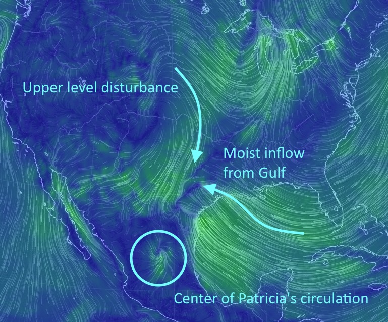
This will lead to a substantial rain event for Texas, including the upper Texas coast. The principal threat remains heavy rain, and more specifically very intense hourly rain rates that exceed the capability of roads and bayous to carry the water away.
RAINFALL
It’s very difficult to accurately predict total rainfall levels when the atmosphere is so pregnant with moisture. That’s because, when precipitable water levels are this high, there’s the potential to produce prodigious amounts of rain very quickly. Predicting precisely where these ingredients will come together is nigh impossible.
With that said, based upon various forecast sources, here is what I consider to be the most likely range of total rainfall that specific areas will receive between now and Sunday evening.
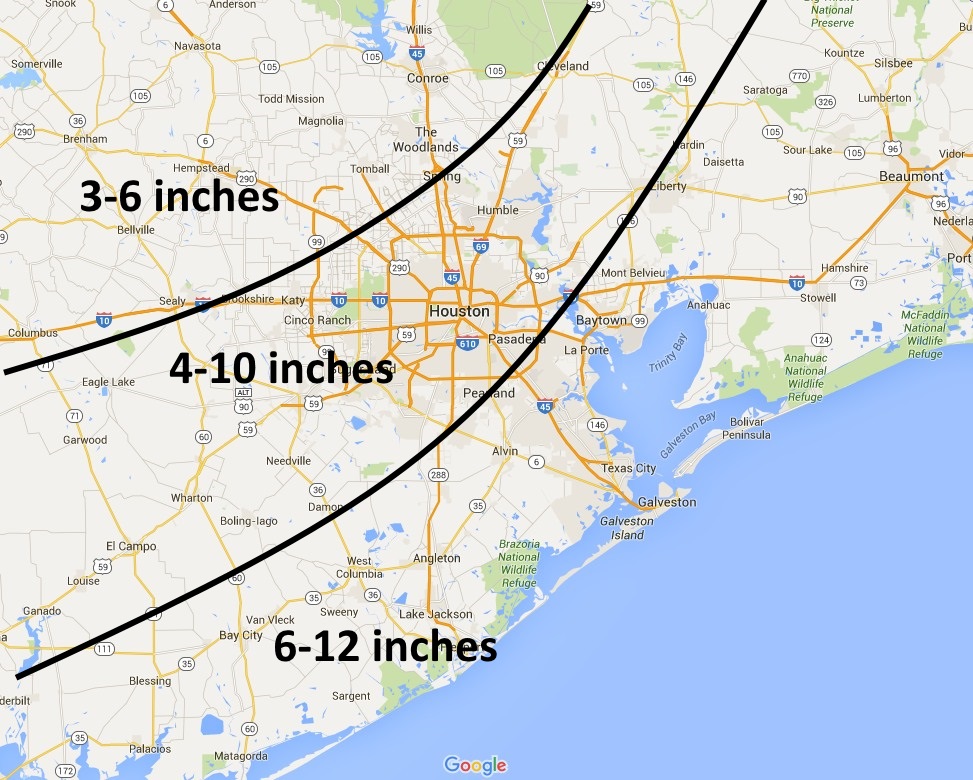
It is important to note that some isolated areas may see higher totals. It simply depends upon where a strong thunderstorm cell slows, or stalls, and that can’t be predicted far in advance. Because of the rainfall rates possible, 3 to 4 inches per hour, storms don’t have to slow for very long to produce flooding.
TIMING
It now seems likely fairly heavy precipitation will enter the western and central part of the Houston metro area this afternoon, with even stronger cells developing between sunset Saturday and sunrise on Sunday.
The heaviest rains should exit the region from west to east, between 9 a.m. and 3 p.m. on Sunday.
I would like to stress again that it will not be wise to have plans tonight or early Sunday morning that take you out of doors and onto roadways. The potential for flash floods will be significant.
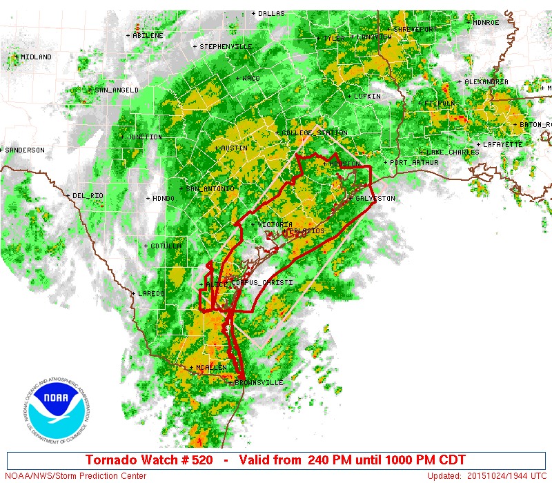
OTHER EFFECTS
We have already seen some funnel clouds on the south side of Houston today, and it’s possible that the stronger thunderstorm cells may sink toward the surface and produce relatively weak tornadoes.
A tornado watch is in effect for much of Houston, and points south, through 10 p.m. tonight:
The associated swells with the remnants of Patricia will increase tide levels by several feet tonight, which should be enough to cause coastal flooding in low-lying areas, including Bolivar, West Galveston Island, Seabrook and the shores of Clear Lake. Tides should fall off by the middle of Sunday.
Winds could get testy too, especially along the coast. Gusts up to 50 mph or so are possible. This is one more reason to remain indoors through the middle of Sunday, until the rains pass.
FUTURE UPDATES
I will update this blog around 4 p.m. today.
Thanks, Eric.
Eric:
You already have a huge following here and on Twitter, and you deserve it, so congratulations on these new ventures, paid and unpaid. What weired timing that Patricia would come along as you depart from Mother Chron. But while we’re at it, how do we know when “rain” tips over into a “rain event?” Does it have something to do with the gauge at the Cynthia Woods Mitchell Pavilion?
Hi Alan, thanks. Something becomes a rain event when … aww heck it’s completely subjective.
I follow you because you use terms like “prodigious amounts of rain “. Awesome and -very clean website- congrats> I know it’s a “weather” site but will you be posting some of your other fun science stuff as well?
No, this site will be almost all weather. My full time job will be writing about space for Ars Technica.
Eric, just out of curiosity, did Ars recruit you, or did you seek them out because you thought it was time for a change from the Chron?
They recruited me, and they made me a compelling offer.
Thank you for keeping us informed – you’re a trusted source for Houston weather.
I wish you all good things in your new ventures and with this new blog.
I like the interactive maps Eric. The wind flow graphic helps me to see why we are potentially locked in with a training effect. Keep up the good work.
Thank you for posting this site. Great information, and so necessary! Praying the rain doesn’t cause flooding, but it’s always good to be prepared!!
Again, many thanks!!
I appreciate the non-hysterical tell-it-like-it-is no-bs style, Eric! I’ll be following you here and on FB…..and STAYING HOME!
Eric,
Words cannot adequately express my gratitude to you for eliminating the last good reason I had for visiting the chronicle’s website. Love your new website and have it saved as a favorite on all the computers I use. Thank you for doing what you do. I wish the best of luck to you in your new job.
Is it possible to compare the potential rainfall/flooding with the Memorial Day event? We flooded then (just south of the Galleria) and we are so afraid it’s happening again.
It is possible that happens again, but most likely the bullseye will fall over other parts of the area.
Add me to email list please
I am reading your blog because we are supposed to be at a wedding in Texas City tonight at 5:30. We would be driving from downtown Houston and trying to decide if we should go or not. She is a good friend so this is a tough decision.
I love your blog Eric – thanks for doing this!
Going there is probably fine, but getting home could be quite difficult.
Thanks so much for continuing to report on the weather! We’ve recently moved from Kingwood to a rural area a few miles SE of Livingston. Any ideas on what we may expect here in terms of rain?
Substantially less rain, perhaps 3 to 5 inches?
Hi Eric. Thought you might like to know a tornado touched down in Pearland this morning at Beltway 8 and Fellows Rd. There are pictures and video in a public Facebook group called Pearland Texas Community.
Thank you Mauricio.
Is there any way for us to support your efforts with this site? Or are you planning to add some sort of advertising at some point?
Yes, I will be adding advertising at some point, or I’d love to find a sponsor. Were that I independently wealthy, but alas I am not.
For now the best way to support the site is to tell your friends and family about it.
Thanks a million–as the priest at downtown Galveston’s Trinity Episcopal Church, I feel informed!
You are quite welcome.
Thanks, Eric. Great work as usual..
This will not help my satellite TV reception while trying to watch the A&M game. Eric can you try to get it to go around Tomball?
I’ll do my best.
You are my main source to get info to our farmers and vendors at our farmers market. You make a difference and a bunch Houston area farmers rely on your information. ~Tim Carlson
Hope the farm business is treating you well, Tim, and thanks for following me over here.
Very thoughtful and helpful
Sincerely appreciate that.
Just wanted to thank you for starting this site. I really enjoy your posts on the weather and I have already bookmarked this site.
As of 3:40pm here in Orange Co., we’ve had a grand total of .04 of an inch….however, our local weathermen said we would not be getting out major rains until after dark of Saturday and then big rain on Sunday.
Yeah, Orange is going to be a little behind Houston in terms of impact. Your heavier rains will be more during the daytime on Sunday, instead of late Saturday night in Houston.
Best of luck.
So glad you’re still doing weather. You are my primary source! Congrats on the new venture & will be following along closely.
Eric,
I always love your no-hype, honest, straight-shootin’ weather, especially in times like this. I love space, too, so I plan to check out both sites. Does either site have an RSS feed? I would to show and share your site to others I work with.