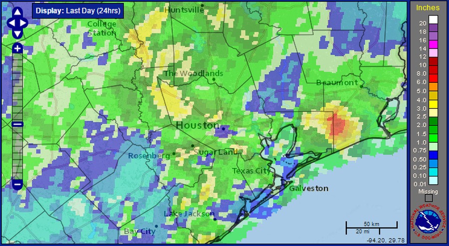
A solid mass of showers and embedded thunderstorms moved through the Houston area on Sunday evening and during the overnight hours, dropping 1 to 3 inches. Although the storms produced some brief street flooding, our dry soils mostly welcomed the rain. Here’s a graphic showing accumulations across the region:
As these storms have pushed off to the east they have left a broad area of sinking air in their wake, which should limit the formation of additional rain showers at least this morning.
Today
The primary question today is whether an additional round of storms will move through Houston. While there is an area of disturbed weather over northern Mexico that will drift north today, I’m not convinced will see another bout of showers due to this sinking air left behind from the Sunday night system. In any case, if it does rain, we probably won’t see additional showers until later this afternoon or evening. Highs should be in the upper 70s under cloudy skies.
Tuesday and Wednesday
Houston won’t experience a classic cold front this week, but fairly persistent winds from the northeast at the surface should eventually bring some drier and cooler weather into the region. Highs on Tuesday and Wednesday should settle into the mid-70s, and overnight lows should fall back into the low 60s for most areas except the immediate coast. With more moist air above the surface we can’t rule out a few showers and thunderstorms developing, but I’m not expecting any well organized storm systems.
Thursday and Friday
Our weather is only going to get better. Under partly sunny skies we should see continued highs in the 70s to end the work week and mark Veterans Day on Friday, with only a very slight chance of rain. Lows should fall into the upper 50s for inland areas, and lower 60s for the coast.
The weekend
Our weather this weekend should more or less be a continuation of this cooler pattern, with highs in the low 70s, partly sunny skies and lows in the upper 50s and lower 60s. The rain forecast is a little uncertain for the weekend, but I’m not seeing any big drivers of widespread precipitation.
Posted at 6:30am CT on Monday by Eric
2.35″ of rain the past 24 hours in beautiful downtown Ellington. My lawn and trees thank you, Eric!
Sad, sad and too bad….only at most .5″ of rain though the estimated rainfall map says over an inch. We missed out on it all. Just drizzles and splats here by hwy 59 and SAN Jacinto river near Kingwood. ?
Every year, the date when we first turn on the heat seems to occur later and later. At this rate, it feels like we’ll be well into December before it’s fired up.